Boston’s “park & pedals” are park and rides for bikes
How do you get more commuters to bicycle into the city? Boston is trying “park & pedals,” dedicated parking lots where suburban commuters can drive to the edge of the city, then bicycle the last couple of miles.
Photo by Park & Pedal.
Bicycling is often the fastest way to travel through dense cities. But most commuters from far-flung suburbs aren’t willing to bike that far every day. Park & pedals split the difference, allowing suburban commuters to drive where it’s easier to drive, then bike through the part of the city where it’s easier to bike.
It’s a fascinating idea, and an unusual twist on the last-mile problem of urban transportation.
The last mile
The hardest part about providing transportation from low-density suburban areas is the so-called “last mile.” That’s the gap between commuters’ homes and a major highway or transit line, where there’s not enough people going to the same place at the same time to provide convenient shuttles.
Park and ride lots around transit stations solve that problem by putting the onus on drivers to get to the station. That’s not as efficient as having people live within walking or biking distance of the transit station, but it’s better than making them drive the full distance into the city.
Transit agencies should never design their entire systems around park and ride users, but a few park and rides at strategic locations can be a good thing.
Why shouldn’t the same idea work for bikes? A few parking lots near major bikeways like the Custis Trail and the Metropolitan Branch Trail might indeed prove useful. Particularly if they’re located far from Metro stations, where it’s not so crucial to reserve land for transit-oriented development.
Official vs unofficial
Boston has an official park & pedal network, with designated lots specifically for drive-to-bike commuters. It opened in 2015 and has been expanding this year.
Boston’s park & pedal network map. Image from Park & Pedal and Google.
Naturally, an official network isn’t strictly necessary for commuters to combine driving and biking. In the Washington region, people hoping to bike the last mile into the city can park at Metro stations, private lots, or even neighborhood streets.
But official parking lots do have some big advantages over doing it ad-hoc. They’re easier to advertise, and they provide natural places for hubs of bike amenities. With park & pedals, planners could add wayfinding signs, maintenance kiosks, secure bike parking, lockers, even bikeshare stations and bus connections. Each one could become a Union Station-like bike station.
Worth the money?
Car parking is expensive and already abundant. With so many demands on transportation budgets and so little money generally available for bike improvements, spending money to subsidize car parking may be a questionable idea. Better to spend it on bike lanes, bikeshare stations, sidewalks, or transit.
But transportation budgets aren’t all-or-nothing. There could be opportunities to partner with parks, churches, developers, and other property owners to designate park & pedals on the cheap, without the need for expensive construction.
Some of Boston’s park & pedals are simply designated sections of on-street parking on public streets, and therefore a matter of policy more than construction. Nothing says DC could not do the same.
As Washington area planners do more to make bicycling easy, park & pedals may well be one more tool to add to the toolbox.
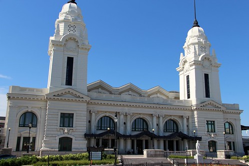
Twenty-five gorgeous but non-famous US train stations
America has abundant famous train stations, from New York’s iconic Grand Central, to Cincinnati’s glistening art deco Union Station, to Denver’s fabulously remodeled Union Station. DC is blessed with a particularly lovely one. But if you only know the famous stations, you’re missing out.
Here are 25 gorgeous train stations from around the US that you may not have seen before.
1. Worcester Union Station
Worcester Union Station. Photo by C Hanchey on Flickr.
Budapest’s gigantic streetcar network is getting some equally gigantic new trams. At about 184 feet long, they’re 4.6 times longer than a standard 40′ bus, and three times the length of a 60′ articulated bus.
The 66 foot long streetcars in DC and Portland are comparatively puny. But extra-long streetcars are common worldwide. Paris, Dublin, and dozens of other cities in Europe use trams around 150 feet long. Toronto runs the longest in North America, a moderate 99 foot long model.
These extra-long streetcars show more clearly how streetcars can be a middle ground between buses and heavy Metro trains. WMATA railcars are 75 feet long each—bigger than a DC streetcar, but less than half a Budapest tram.
DC Circulator may add a line to NoMa, but its circuitous routes aren’t ideal
You might someday ride a Circulator bus from NoMa to Starburst. Or maybe from NoMa to U Street, Columbia Heights, or Logan Circle. DDOT is doing a study to decide.
NoMa Circulator options. Image by DDOT.
NoMa as transit hub
NoMa is one of DC’s fastest-growing neighborhoods. With 40,000 workers, 18,000 residents, and huge new developments coming soon, it’s fast becoming an extension of downtown, and a natural hub of activity.
But aside from its crucial Red Line Metrorail station, NoMa is a transit afterthought. While most Metro stations double as bus hubs, no public bus lines have stops directly at NoMa Metro.
WMATA’s important 90s series Metrobuses pass nearby on Florida Avenue, and the X3, 80, P6, and D4 all skirt the edges.
But that’s nothing like the bus service in downtown, or other downtown-adjacent neighborhoods. It’s too paltry to do much to help residents of nearby neighborhoods like Trinidad or Truxton Circle reach NoMa.
If NoMa is to become the great nerve center of Northeast DC, it’s simply going to need better transit connections to the rest of Northeast.
Enter DC Circulator
With bus service every 10 minutes all day, DC Circulator certainly qualifies as a good bus. Making NoMa the focus of a new Circulator line will absolutely be a great addition.
As always, the devil is in the details.
DDOT planners are considering 5 potential routes, going in wildly different directions.
Some options eschew Northeast and connect only to Northwest destinations like Columbia Heights, U Street, or Logan Circle. Other options have a leg extending east on Florida Avenue as far as Starburst and Benning Road.
Further connections to Northeast, like extending the line up Bladensburg Road, aren’t on the table.
Theoretically DDOT need not select only one option. They could pick and choose the best aspects from multiple options, and stitch them together for a final hybrid.
Proposed routes are too complex
One serious concern with all five routes is that they’re too complex.
The most successful bus lines are usually simple, direct, and consistent. Straight lines are easier for riders to understand and remember, and reach destinations faster than squiggly circuitous routes like these NoMa proposals.
This graphic comparing the most and least successful bus lines in Vancouver nicely illustrates the issue:
Image from Vancouver TransLink.
Buses in DC absolutely follow the same pattern. The highest-ridership lines in the city are virtually all straight and direct, like on 16th Street and Georgia Avenue. Meanwhile, complex, circuitous routes like the W2 don’t get many riders, despite connecting multiple destinations with a lot of potential riders.
The problem is M Street
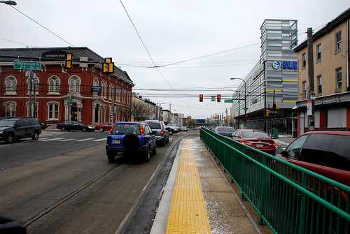
Theoretically M Street NE is the natural spot for an east-west bus through NoMa. It offers a straight shot through the underpass below the railroad tracks. The southern entrance to NoMa Metro spills out onto it, and M’s corner with First Street NE is the center of the neighborhood.
M Street NE. Photo by Ted Eytan on Flickr.
Unfortunately, running a bus on M Street is difficult. Although it’s two-way through the heart of NoMa, it switches to one-way on both the east and west sides. Unless DDOT reconfigures M Street to be two-way (a prospect that might wipe out the nice protected bike lane), there is simply no east-west line through NoMa that’s both straight and provides a direct Metrorail connection.
Complexity is, unfortunately, probably mandatory.
But still, some of DDOT’s alternatives minimize complexity, while others are needlessly circuitous. That New Jersey Avenue option is bonkers. Four blocks is too far to separate one-way pairs.
Tell DDOT what you think
DDOT will be hosting a series of public meetings this month to discuss this proposal. You can weigh in at sessions on November 10, 12, 15, 17, or 19.
High-rise mobile homes could revolutionize apartment living
Mass-produced mobile homes are one of rural America’s most important forms of housing. One company wants to try the same concept with urban apartments. It’s a batty idea that may not work, but if it does, it could help to solve America’s urban affordability crisis.
The idea works like this: Rather than custom-designing every individual building, what if apartment buildings were mere frames, and apartments were mobile boxes that simply slipped into docks, the way cars park in a parking garage?
When people who live in mobile apartments move from one city to another, they could take their entire apartment with them. Slide out of your frame in Denver and slide into one in San Francisco, and keep on living without the disruption of emptying your home to a shell.
Perhaps most importantly, the company pushing this idea says they’d be drastically cheaper than a studio apartment.
The company, Kasita, is building a prototype in Austin next year, where they say they’ll rent units for around $600 a month. That’s half the cost of a downtown Austin studio.
Trade-offs abound
Obviously, there are trade-offs to this idea. At 200 square feet, these would be small apartments. Suitable for a single person, crowded for a couple, and hard to work with for a family.
Kasita’s version comes comes with high-tech bells and whistles like customizable wall panels, including speakers, shelves, a bike rack, even a fish tank and fireplace. But surely, if this concept takes off, competing companies would begin to offer more bare-bones versions.
Bells and whistles. Rendering from Kasita.
Kasita’s claim of $600 per month remains theoretical, and who knows how much it would actually cost to move one.
And aesthetically, a lot of people will think they’re ugly. Like shipping container apartments, mobile apartments will necessarily have an industrial look. A city full of these might quickly begin to feel oppressive.
The Japanese example
This is actually not a new idea. Japan has been home to some experiments in capsule architecture, most notably the 1972 Nakagin Capsule Tower. But Nakagin proved impractical and unpopular, and has slipped into disrepair. Fair from proving the concept works, it actually shows how failure is more likely than success.
These are real trade-offs, impossible to ignore. But given America’s growing affordability crisis, maybe they’re trade-offs that are worth experimenting with, sometimes, in some places, for some people.
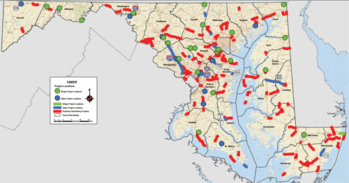
On the map, blue lines and dots illustrate major highway projects. Red lines are smaller road projects, and green dots are bridge projects.
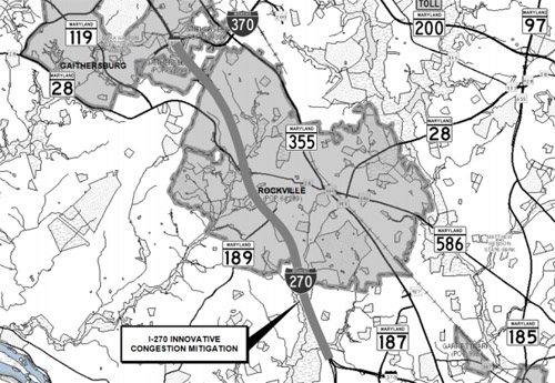
There are three major highway projects in the Washington region, on I-270, the Beltway, and Route 1. Most of the money is going to projects in other parts of the state.
Officials haven’t determined the exact location or mix of projects yet, but all three of those strategies have helped Virginia squeeze more capacity out of I-66.
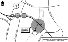
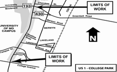
Greenbelt interchange (left) and US-1 in College Park (right). Images from Maryland.
The Greenbelt project will add new highway ramps, so drivers coming from northbound I-495 will be able to get to the Metro station, and so drivers leaving Metro will be able to reach southbound I-495. Those movements aren’t possible today.
The College Park project will make US-1 a four-lane highway with a raised median, and add better bicycle and pedestrian accommodations. This is the same project GGW has advocated for over the past year, although it’s not clear from Hogan’s announcement what the final design will look like.
Most of the money goes elsewhere
Those three projects will most directly affect Washington-area drivers. Here are the biggest new projects elsewhere in the state:
$160 million to widen MD-404 in Queen Anne’s, Talbot, and Caroline Counties
Here’s the complete list of major road projects statewide. In addition to new projects, the list also includes $645 million in “preserved” funding for projects for which MDOT had already budgeted.
The Cairo is DC’s oldest and tallest residential skyscraper. When it opened in 1894, policymakers were so troubled over its height that they soon enacted the District’s famous height limit. 121 years later, The Cairo still towers over Dupont so much that it offers one of the city’s best views.
Scroll right to view panorama. Click for larger version. All photos by Dan Malouff.
The first panorama begins looking north. The patch of trees at the extreme left edge of the image are in Meridian Hill Park. Scrolling right the view shifts to look east, then turns to straight south and downtown DC. The panorama’s right edge looks southwest, with the peaks of Rosslyn in the background.
This second panorama continues to pan west. Beginning with downtown on the left edge, scrolling right yields views of Rosslyn, Q Street rowhouses, and eventually the National Cathedral.
Scroll right to view panorama. Click for larger version.
Here’s the view directly north:
Zoomed in on Meridian Hill:
Straight south, with the White House peeking around a corner, and the Potomac River in the distance:
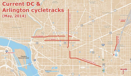
With DC’s M Street and 1st Street cycletracks on the ground, the central city network of protected bike lanes is starting to actually look like a network.
Base map from Google.
This map shows every cycletrack in town. In addition to M Street and 1st Street, there’s L Street, Pennsylvania Avenue, good old reliable 15th Street, and the diminutive R Street lane near the Metropolitan Branch Trail.
For the sake of completion the map also shows Rosslyn’s super tiny cycletrack, which exists mainly to access a popular Capital Bikeshare station.
Philadelphia’s streetcar infrastructure: Old but interesting
Philadelphia’s streetcar network is the largest and busiest in the mid-Atlantic. It has several interesting features, some of which can help inform the planning for DC’s growing system.
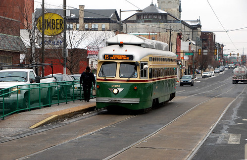
Philadelphia’s Girard Avenue trolley, with island platform.
Philadelphia calls its system trolleys instead of streetcars, because it’s vintage from the original trolley era. While Philadelphia did discontinue many of its original trolley routes, unlike DC they also kept many.
The Girard Avenue trolley line even uses vintage trolley vehicles, originally built in 1947. It also runs in a unique on-street arrangement, with tracks down the center of wide Girard Avenue, and stations in narrow floating medians.
The Girard Avenue trolley’s floating platforms.
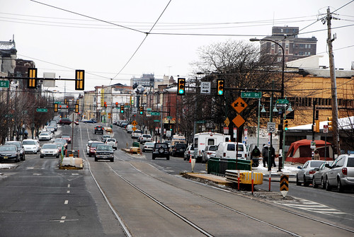
The Girard Avenue arrangement is totally different than DC’s H Street layout, which uses a mixture of curbside and full median tracks.
Philadelphia’s center-running tracks result in fewer conflicts with parked or turning cars, which speeds the trolleys down their route. It’s almost-but-not-quite like a dedicated transitway.
Unfortunately, the platforms are too narrow to meet modern disability-accessible design guidelines. If DC were to use a similar arrangement, we’d need wider platforms and thus more street width.
Narrow platform on the Girard Avenue trolley line.
On narrower streets in West Philadelphia, trolleys still run in the center, with bike lanes between the tracks and a row of parked cars.
West Philadelphia trolley line.
The trolley subway
Five trolley routes that run on-street in West Philadelphia combine and then move into a dedicated trolley subway to speed through Center City. It’s a great way to maximize the efficiency of the system through its most dense and congested section, while still taking advantage of the flexibility of on-street operations further out.
13th Street trolley subway station.
DC once had a short trolley subway too, under Dupont Circle. Today, DC’s reborn streetcar plan doesn’t call for any. They’re hugely expensive, after all. But with the specter of Metrorail capacity constraints looming, and new DC subway lines under consideration, perhaps someday a streetcar subway could again be appropriate in DC.
What else is there?
I’ve never personally lived in Philadelphia, so my experience with its trolley network is fairly limited. I’m sure there are other interesting features. What did I miss?
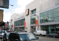
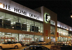
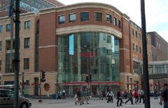
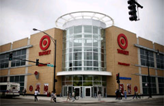
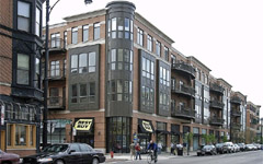
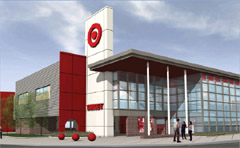
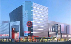
A few years ago the idea of a pedestrian friendly big box store was almost unthinkable, but the idea is catching on, with several examples locally and around the country.
Locally the Columbia Heights Target is an obvious example, but not the only one. We also have the Tenleytown Best Buy, and of course, the proposed downtown Wal-Mart. In the suburbs, Gaithersburg’s new urbanist “Washingtonian Center” was an urban big box trail-blazer. Designed and built in the late 1990s, it features what may have been the country’s first pedestrian oriented Target, Dick’s Sporting Goods, and Kohl’s.
Below there are pictures of several other examples from around the country, including a Home Depot in Chicago that puts DC’s to shame.
Home Depot, Halsted Street, Chicago. Photo by dmitrybarsky.
Home Depot, Halsted Street, Chicago. Photo by Payton Chung.
Target, Nicollet Street, Minneapolis. Photo by DesertDevil.
Target, Broadway, Chicago. Photo by Chicago Tribune.
Best Buy, Lockwood Place, Baltimore. Photo by Joe Architect.
Best Buy, Clark Street, Chicago. Photo by VivaLFuego.
Proposed Target, East Liberty, Pittsburgh. Photo by City of Pittsburgh.
Proposed Target, 4th and Mission Streets, San Francisco. Photo by SF Redevelopment Agency.


 Comment on this at the version cross-posted to Greater Greater Washington.


