|
Special Features


Image Libraries


|
|
Blog
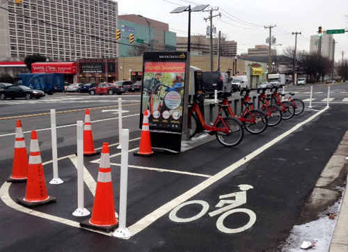
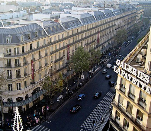
DC like Amsterdam? We can only hopeAccording to yesterday’s Express, DC is starting to look a lot like Amsterdam, and not just because of marijuana. That’s fantastic if true.
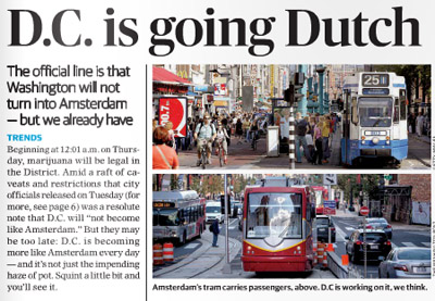
The top of yesterday’s Express story.
Among the reasons the Express cites for DC’s Amsterdamization are increasing bicycle use, the appearance of streetcars, and Georgetown’s improving C&O Canal.
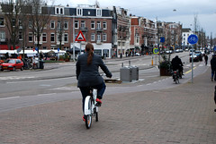
Amsterdam is one of the world’s great bicycling and streetcar cities. It’s a joy to travel along its extensive bikeways, and even lanes where cars are allowed are amazingly bike friendly. And Amsterdam’s huge streetcar network (with streetcars in both dedicated lanes and mixed traffic) is a case study in successful urban transit.
DC’s nascent bikeway and streetcar networks pale in comparison, but Amsterdam is a superb model for us to aspire towards.
And if it’s true that we can never hope to have as many canals (short of a disastrous global warming-induced flood), we can at least ponder what might have been had the history of Constitution Avenue turned out differently.
Even more similarities
Transportation and canals aside, Amsterdam’s overall urban design is actually incredibly similar to DC’s. We’re both predominantly rowhouse cities, with plenty of brick. Even our street grids are similar: Amsterdam has a relatively small core with twisty medieval streets, but for the most part it’s a city of straight streets and radial avenues just like DC.
These scenes from Amsterdam wouldn’t look all that out of place in Dupont Circle, U Street, or Adams Morgan, apart from how little street space goes to cars..
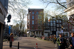 
Amsterdam, but could be DC.
Admittedly, Amsterdam beats DC in a lot of ways. But it’s not Paris or Hong Kong, not so thoroughly alien. And DC is not Las Vegas. Amsterdam and DC aren’t identical, but we’re the same species of city, which means Amsterdam is better in ways that DC can practically emulate.
Plus, we’ve got Amsterdam Falafelshop.
 Cross-posted at Greater Greater Washington. Cross-posted at Greater Greater Washington.
February 26th, 2015 | Permalink
Tags: architecture, bike, streetcar, transportation, urbandesign

Best way to protect a bikeway? How about a bikeshare stationHow’s this for a natural idea: Locate bikeshare stations between a street’s protected bikeway and car lanes.
That’s exactly the arrangement in Crystal City, where the Capital Bikeshare station at 23rd and Eads helps to form part of the bikeway’s protective barrier.
23rd and Eads. Photo by Euan Fisk on Flickr.
DC has at least one example, on 6th Street NE next to Union Market. You can also find this arrangement in New York, Paris, and a ton of other cities.
It’s just a nifty, straightforward idea that’s too sensible not to use.
Cross-posted at Greater Greater Washington.
January 28th, 2015 | Permalink
Tags: bike, transportation, urbandesign
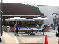
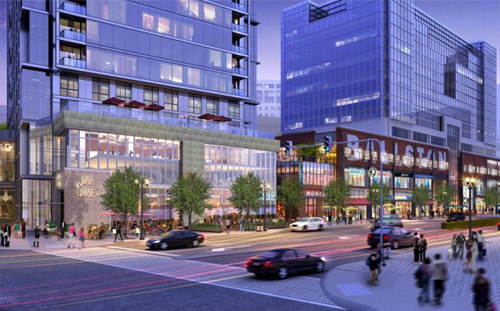
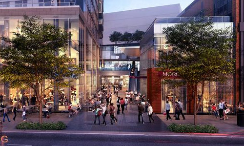
With its new plaza, Tysons begins to feel urbanMetro’s Silver Line isn’t the only indication the transformation of Tysons Corner is clearly underway. Further undeniable evidence: The Plaza, a popular new urban-style open space at the front door to Tysons Corner Center mall.
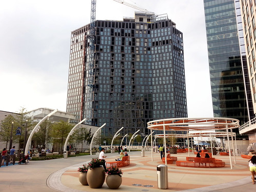
The Plaza (that’s its official name) is on the north side of the mall, near the pedestrian bridge from the Tysons Corner Metro station. Three new high-rises are under construction around the plaza, tightly enclosing the space like a genuine city square.
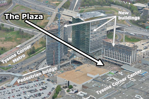
The Plaza and its surroundings. Original photo from Macerich.
The pedestrian bridge to the Metro station isn’t open yet, because the high-rise it connects is still under construction. But when all is said and done, The Plaza will become the main entry point to the mall from the Metro. In a very real sense it will become the center of this emerging urban neighborhood.
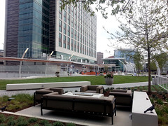
Befitting Tysons, The Plaza is a thoroughly contemporary update on the classic city square. There’s no marble statue in the middle, no grand fountain like in Dupont Circle. Instead, there are padded couches, small-scale artistic flourishes, and outdoor games.
 |
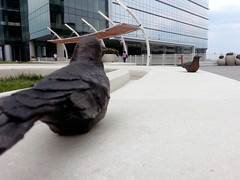 |
| Couches (left), and sculpted birds (right). |
 |
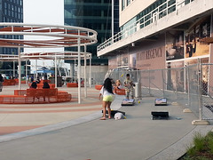 |
| Ping pong (left) and corn hole (right). |
The first plaza-fronting retail, a Shake Shack, opened earlier this week. More is coming soon.
One crucial difference between The Plaza and a traditional city square is who owns it. This may masquerade as civic space, but it’s clearly private property. Security guards patrol the square, and you can bet homeless people aren’t welcome to sleep on benches.
But still, The Plaza is a big step forward for Tysons. It’s a genuine gathering place, and people are using it. Even without the Metro connection, plenty of other people were hanging out nearby when I visited last weekend. It’s not the kind of place that a mere 20th Century office park would support.
Cross-posted at Greater Greater Washington.
August 14th, 2014 | Permalink
Tags: development, fun, parks, urbandesign
If the FBI moves to Greenbelt, here’s what it will look likeThe FBI is considering moving its headquarters from downtown Washington to either Greenbelt, Landover, or Springfield. If they pick Greenbelt, here’s what the development will look like:
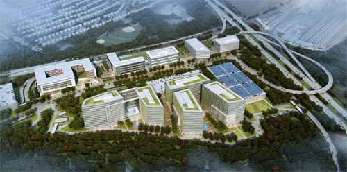
Greenbelt development rendering. Image from Renard Development/Gensler.
Under this plan, a new mixed-use transit-oriented development would replace the parking lot at the Greenbelt Metro station. The FBI would occupy the five buildings on the bottom of the rendering, with other offices, apartments, retail, and a hotel taking up the rest.
Greenbelt Metro station is located in the upper left side the rendering, immediately behind the building that looks like a “6” digit tipped on its side. To the right of that building, a central plaza would be the area’s main public space, and one of Prince George’s most urban spots.
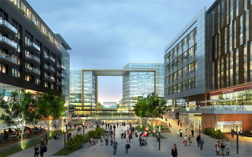
Proposed view from the Greenbelt Metro station. Image from Renard Development/Gensler.
The Metro’s existing entrance is immediately behind the “6” building. It would be nice if a new Metro entrance would line up directly with the plaza, though it looks more like a short walkway behind the building will connect the station to the plaza.
Since Greenbelt is an end-of-line station, the development replaces all the Metro commuter parking. But instead of surface parking lots, it would go in a new parking garage shown on the far left of the overview rendering, connected to the station with a wide, suburban-style street.
Clustering mixed-use development next to the Metro station and putting the FBI buildings and park-and-rides across the street makes a lot of sense. That layout provides a parking lot for commuters and gives the FBI the space it wants for a buffer without sacrificing the walkability of the entire neighborhood.
Meanwhile, FBI workers who don’t commute via Metro would use the parking garage on the far right, next to the Beltway.
Overall, this looks like a decent plan. There are a lot of less than ideal trade-offs, but given the demands of an end-line station and the FBI, it’s not terrible.
Cross-posted at Greater Greater Washington.
July 31st, 2014 | Permalink
Tags: development, urbandesign
How do you fix Ballston mall? Make it less like a mallProblem: The Ballston Common Mall isn’t working very well. Solution: Open the mall up to the surrounding streets, so it becomes the center of a lively community rather than a walled-off separate place.
Concept for Ballston mall renovation. Images from Forest City.
Ballston is one of the smallest malls in the region. It can’t compete well against bigger centers with more stores, like Pentagon City or Tysons Corner. Instead, the mall generally only draws customers from a small area nearby, and thus makes less money than other, bigger malls.
Meanwhile, being an enclosed mall that serves mostly local traffic, it saps sidewalk retail away from Ballston’s neighborhood streets. Stores that would otherwise be on the sidewalk are instead bottled up in the mall.
To fix this, developer Forest City plans to face more stores to the sidewalk, and give them more inviting storefronts. It will replace nondescript mall doors with open-air plazas that naturally extend the street into the mall. Capping the building will be a new 29-story residential tower.
Concept for open-air plaza.
Forest City still needs to work with Arlington County to finalize and approve plans. For now, these are just concepts. But if all goes well, the 1980s-style Ballston Common Mall will transition to become the contemporary Ballston Center in 2017 and 2018.
Cross-posted at Greater Greater Washington.
July 1st, 2014 | Permalink
Tags: development, urbandesign
How to make cycletracks public artAs more cities build more protected bike lanes, some are beginning to use them as opportunities for public art. In Seattle, the new Broadway cycletrack includes a section with “art bollards.”
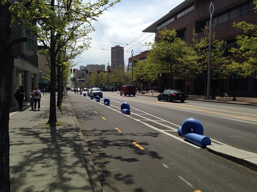
Seattle cycletrack. Photo by Gordon Werner on flickr.
Most cycletracks around the US use flexposts or concrete curbs to separate the bike lane from car traffic. A few use other methods like parking stops or zebras, but there are better-looking options available.
In addition to Seattle’s art bollards, a growing number of cities use landscaped barriers.
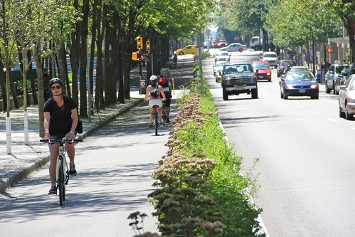
Vancouver cycletrack. Photo by Paul Kreuger on flickr.
These are great ideas. As cycletrack networks continue to expand, cities around the country can look for opportunities to make their bike lanes more beautiful.
But that being said, beautification adds time and expense to construction, and most cyclists would likely rank having more usable cycletracks sooner as a higher priority than art or landscaping.
So art is great, but there’s definitely a place for easy, cheap flexposts.
Cross-posted at Greater Greater Washington.
June 16th, 2014 | Permalink
Tags: bike, transportation, urbandesign
DC’s most useless park is a parking lot in disguiseCapping an underground parking garage with a public park is such a nice idea. It’s a shame DC’s most prominent example is such a terrible park.
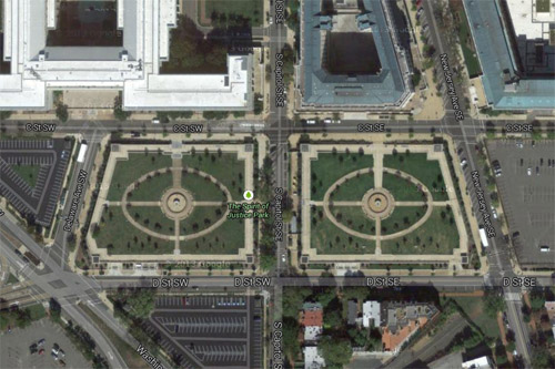
Spirit of Justice Park. Image from Google.
The South Capitol parking crater is undeniably one of DC’s most inappropriately underused plots of land. It’s 6 complete blocks of parking lots, all in a cluster mere steps from the US Capitol.
By all rights these blocks should be active and vital parts of downtown DC. Instead, they’re under the jurisdiction of the Architect of the Capitol, and thus off-limits to the normal rules of city building. In the vacuum of capitol complex land management, vast parking lots for Congresspeople and their staffs are a higher priority than housing, amenities, or attractive streetscapes.
So it’s nice that federal planners at least tried to spruce up this neighborhood-sized sea of asphalt with Spirit of Justice Park, a cap atop a two-block section of parking that’s covered with green space.
Unfortunately, it’s a lousy park.
The biggest problem is that rather than sink the parking below grade, the park is raised a level above the sidewalk. As a result, many people only see an imposing wall, and have no idea the park behind it even exists.

The sidewalk in front of the park. Image from Google.
People who actually want to enter and use the park must find one of only four entrances over the entire two-block area. Of the four entrances, two face the congressional office buildings and one faces the street between the two park blocks (though you can’t walk between them directly), leaving only a single entrance on the south side facing away from the capitol complex towards the public city.
Meanwhile, there are no visible entrances facing east nor west.
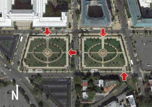
Entrances to Spirit of Justice Park. Image originally from Google.
That’s not the only problem. With a parking garage directly beneath the grass, the park’s soil is too shallow to support trees large enough to provide shade or protection against wind. The park is uncomfortably hot in the summer, and cold in winter.
Finally, management apparently only cares about capitol complex workers, because the fountains at the center of each block are switched off over the weekend.
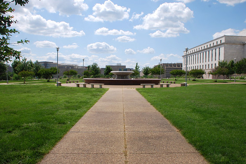
Small trees and a dry fountain hidden behind a wall. No people.
The overall message is that the public is barely tolerated in this park, not really welcome, and certainly not a priority. As a result, the public mostly stays away.
A park that’s not used is a useless park. We can do better.
Cross-posted at Greater Greater Washington.
May 27th, 2014 | Permalink
Tags: government, parks, urbandesign
Lipstick can help the Tysons pig, a littleFairfax County is considering dressing up the Silver Line’s mammoth concrete pylons with murals. The idea could help animate the otherwise bleak, gray structures.
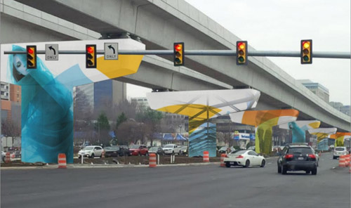
Mock up of a possible Silver Line mural. Image from the Tysons Partnership.
Ideally the Silver Line would’ve been underground through Tysons Corner. But federal rules that have since changed prevented that, forcing the Metro line above ground, onto a huge elevated structure.
That wasn’t the end of the world, but it did condemn Tysons to some unnecessary ugly.
So why not dress it up? Murals can unquestionably make big gray structures more colorful and interesting. They’re easy to implement, don’t cost very much, and help a little. There’s not much down side.
Murals are, however, still just lipstick on a pig. They don’t solve the underlying deadening effect of bare walls. For example the Discovery building mural on Colesville Road in Silver Spring is surely better than bare concrete, but shops & cafes would’ve been better still.
And Tysons’ murals won’t be as effective as the one in Silver Spring. Colesville Road is basically urban, basically walkable. The block with the mural is the weakest link on an otherwise lively urban street.
But in Tysons, the Silver Line runs down the middle of Leesburg Pike, one of the most pedestrian-hostile highways in the region. If murals are added to the Silver Line, they may become the best and most interesting part of the streetscape, as opposed to the worst.
So by all means, Fairfax County should absolutely do this. Murals are a great tool to cover any large blank structure. But what Tysons really needs is walkable streets with lively sidewalks.
Cross-posted at Greater Greater Washington.
April 11th, 2014 | Permalink
Tags: architecture, metrorail, transportation, urbandesign
Notes from Europe: 19th Century urban renewalI’m on vacation in Europe until the 24th. Each weekday until my return there will be a brief post about some feature of the city I’m visiting that day.
Without a doubt, Paris is home to the world’s most successful urban renewal scheme. The Haussmann Plan was carried out primarily between 1853 and 1870, and significantly contributed to the creation of Paris’ most famous boulevards and its iconic architectural style.
Under the guidance of city planner Baron Georges-Eugène Haussmann, large sections of Paris were demolished and rebuilt along wider, grander, straighter boulevards. And new building regulations were adopted that delineated the height and form of buildings.
Boulevard Haussmann, with its strictly regulated buildings.
Photo by Thierry Bézecourt via Wikepedia.
March 19th, 2014 | Permalink
Tags: architecture, history, History of cities, urbandesign
Notes from Europe: Versailles was DC’s prototypeI’m on vacation in Europe until the 24th. Each weekday until my return there will be a brief post about some feature of the city I’m visiting that day.
Versailles was the seat of the French monarchy for over 100 years, through the bulk of the 18th Century. Its baroque design had a major influence on Pierre L’Enfant’s design for Washington, DC.
This photo shows the palace and the Place d’Armes, but doesn’t it look an awful lot like the westward view from the US Capitol?
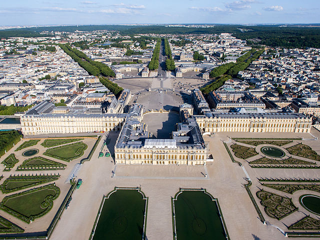
Versailles. Photo by Lionel Allorge via Wikipedia.
March 17th, 2014 | Permalink
Tags: history, urbandesign
|
Media


Site
About BeyondDC
Archive 2003-06
Contact
Category Tags:
Partners
|


