|
Special Features


Image Libraries


|
|
Blog
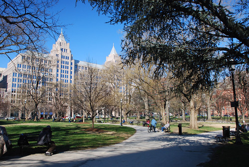
Notes from Seattle: A very complete streetEach day this week while I’m in Seattle for Railvolution there will be a brief post about some cool transportation-related thing in that city.
Seattle is currently rebuilding its Broadway corridor to add a new streetcar line. When complete, Broadway will have both a streetcar and a cycletrack, making it one of America’s most multimodal streets.
It’s going to be quite a sight.
Seattle’s Broadway corridor. Video from SeattleStreetcar.org.
Tomorrow: Ferries.
 Cross-posted at Greater Greater Washington. Cross-posted at Greater Greater Washington.
October 24th, 2013 | Permalink
Tags: bike, streetcar, transportation, urbandesign

The future of San Francisco transit, according to Star TrekTake a look at this street scene from the recent Star Trek movie. It shows San Francisco in the year 2259.
Apparently in the universe of Star Trek, city streets will look pretty much the same 246 years in the future as they do today. Cars, a cable car, and a fancy articulated bus, all on a road with basically 20th Century lane markings. The pedestrian crossing and traffic signals are different, but it’s a wholly recognizable scene.
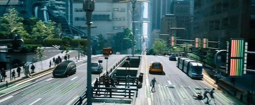
From Star Trek Into Darkness.
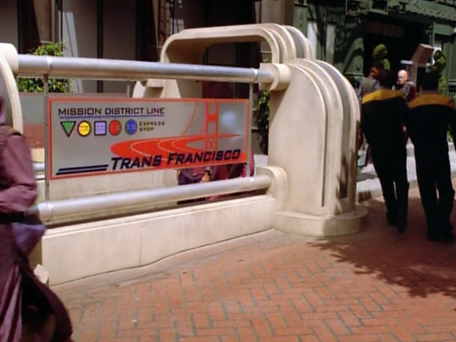
On the other hand, by the year 2372 things change quite a bit. These next 2 images are from the Star Trek: Voyager episode Non Sequitur, and show a street in San Francisco’s Mission District.
It’s a fully pedestrianized space, complete with a subway entrance to the fancy future Trans Francisco subway system. Very progressive overall.

From Star Trek Voyager.
From Star Trek Voyager.
October 11th, 2013 | Permalink
Tags: bus, fun, metrorail, transportation, urbandesign
DC planners want height limit that’s targeted, not bluntThe DC Office of Planning (OP) suggests replacing the blunt citywide height limit with more targeted rules that would slightly increase heights downtown, and give DC the option to allow taller buildings elsewhere.
Under the proposal, the existing federal height limit would only apply to the L’Enfant City, and would change to allow modestly taller buildings. Elsewhere, DC would set its own limits using the local zoning process, which already requires federal and public input.
DC’s skyline today. Photo by the DC Office of Planning.
In many parts of DC, the zoning code already restricts height more than federal law, so this would result in no change for those areas. But for other peripheral neighborhoods, especially near Metro stations, it could potentially allow taller buildings.
Even so, it would take long public processes to rezone any land for taller buildings. To do so, the change would first have to be part of the District’s Comprehensive Plan. After that, the Zoning Commission has to approve specific new zoning. At each stage there are opportunities for public feedback, and 2 of 5 members on the Zoning Commission are federal appointees.
Within the L’Enfant city, the report recommends modifying the height limit to allow slightly taller buildings. The current height limit restricts buildings to the width of the street plus 20 feet. OP recommends changing that to be simply 125% the width of the street.
In practice that’s a very modest increase. Pennsylvania Avenue is 160 feet wide, so its height limit is currently 180 feet. Under OP’s 125% proposal, it would rise to 200 feet.
OP’s report follows a National Capital Area Planning Commission (NCPC) study of the issue. NCPC’s own recommendations earlier this month called for similar but more modest changes.
For downtown DC, NCPC recommended allowing humans to use mechanical penthouses, which would effectively raise the height limit by one floor, as long as there are setbacks. Outside downtown, NCPC suggested further study but not yet any action.
OP argues that ensuring the economic stability and vitality of the capital city is a compelling federal interest, and reason to modify the height limit.
The ultimate decision will rest with Congress, which passed the original height limit law and is the only body which can change it.
Cross-posted at Greater Greater Washington.
September 25th, 2013 | Permalink
Tags: urbandesign
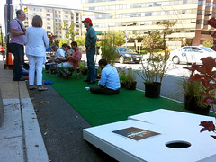
Turn parking into parks for Park(ing) DayToday is Park(ing) Day, and all across the US city-dwellers are claiming car parking spaces and temporarily converting them to parks for people.
Instead of using all our street space to store cars, why not use some of it to make our cities nicer places to live? On Park(ing) Day, groups find an on-street parking space, pay the meter to claim it legally, and instead of parking a car, they park seats, tables, plants, or whatever.
Groups are sponsoring parklets all over the DC region today. I visited two near my Arlington office alone.
 |
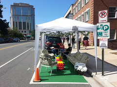 |
| Parklets on Clarendon Boulevard (left) and 14th Street North (right). |
Cross-posted at Greater Greater Washington.
September 20th, 2013 | Permalink
Tags: parks, roads/cars, transportation, urbandesign
NCPC will likely recommend tweaking DC height limit
|
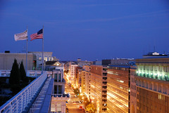
Downtown DC. |
The National Capital Planning Commission (NCPC) study considering whether or not to raise DC’s height limit is unlikely to recommend major skyline-altering changes. But it will suggest tweaking the rules to add more flexibility, and leaves open the possibility of taller buildings outside downtown.
In his report to NCPC, executive director Marcel Acosta will recommend against raising the height limit significantly downtown, but will suggest changing the rules regarding rooftop penthouses.
The rules currently allow unoccupied mechanical-only penthouses to breach the height limit by a few feet in certain situations. Acosta will propose allowing active human use of those spaces.
Acosta will also recommend that NCPC further consider raising the height limit for areas outside downtown, where the impact on the monumental core would be negligible. That might allow places like Anacostia or Tenleytown to develop along more similar lines to Arlington and Bethesda.
The NCPC will vote on an official recommendation in November, after hearing Acosta’s report and gathering public feedback. Following that, Congress will have the power to either pass a bill making changes, or retain the status quo.
Cross-posted at Greater Greater Washington.
September 11th, 2013 | Permalink
Tags: master planning, urbandesign
Montgomery rethinks Bethesda Purple Line stationThe Bethesda Purple Line station is currently planned to squeeze into an existing tunnel below Bethesda’s Apex Building. But planners are now considering an alternate plan to tear down the Apex Building and redevelop the entire site.
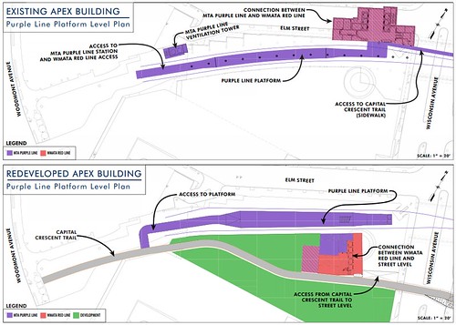
Existing plan (top) and alternate proposal (bottom). Images by Maryland MTA.
Between Silver Spring and Bethesda the Purple Line will run on land from a former railroad line. Years ago the railroad sold the development rights above the tracks in downtown Bethesda. Now there are two buildings atop the rail corridor, the Apex Building and the Air Rights Building.
The Purple Line will pass easily under the Air Rights Building, but the Apex Building needs to accommodate a station. And while the tunnel there was designed to carry tracks, it wasn’t originally built to hold a station. The structural columns supporting the building come down into the rail tunnel, severely constraining the space.
Planners can squeeze a station in the existing space, but the result is a narrow platform crowded with building columns.
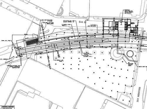
Apex Building column layout. Image by Maryland MTA.
Meanwhile, there are other problems with the existing arrangement. There’s not enough room in the tunnel for both a light rail station and a bike trail, so the trail is planned to be moved to the surface.
Also, building a subway station under the Apex Building would complicate any potential future redevelopment prospects. Since the Apex Building is only 5 stories tall, it’s already shorter than most other buildings nearby, and it will become a prime redevelopment candidate after Bethesda becomes a key Purple Line / Red Line transfer point.
Redeveloping now could solve the problem
The new proposal suggests tearing down the Apex Building, building the Purple Line station in a new custom-built trench, adding a 2nd tunnel for the trail, and then allowing the owners of the Apex Building to replace it with a bigger building.
Montgomery County is currently in talks with the owner of the building, and is working through a minor master plan amendment to determine the density and height.
If the new plan is approved, all the pieces will work together better. The Purple Line station will be simpler and more spacious, bike riders will have an uninterrupted dedicated trail, and one of the most transit-accessible properties in Montgomery County can be redeveloped at a more appropriate density.
It would be win/win/win.
As long as this doesn’t delay the rest of the Purple Line, I say let’s do it.
Cross-posted at Greater Greater Washington.
September 10th, 2013 | Permalink
Tags: development, lightrail, master planning, transportation, urbandesign
Four suggestions for a new Franklin SquareDC and the National Park Service are partnering to redesign Franklin Square, the largest of the parks lining K Street in downtown DC. As they draw up plans, here are 4 ideas that will help transform Franklin from one of DC’s most underused parks into one of America’s best public spaces.
Franklin Square today.
Work with the city’s edges
Most of downtown DC’s existing squares pay little attention to what’s around them. They’re laid out symmetrically, with paths emanating outward from a central statue through grass and trees to the street. Each side is close to identical, regardless of what’s across the street. That works well for small spaces like Dupont Circle or McPherson Square, but not for larger ones like Franklin Square.
Larger squares need multiple sub-areas, each with distinct attributes that reflect what’s around them. Franklin Square is big enough that it shouldn’t be symmetrical. The more active 14th Street side should be more welcoming to large numbers of people, and should have more hardscaping and mixed-use. Conversely, the less active 13th Street side should be quieter and more park like.
Embrace transit
One big reason the 14th Street side is more active is the entrance to McPherson Square Metro station at 14th and I Streets. That’s a big opportunity. Rather than treating that as just another corner, no different from the other 3, the new design for Franklin Square should focus acutely on the Metro station. That corner should be the most intense part of the park, and should function as its unofficial center.
New York’s Union Square is a great example of what that might look like, with its hardscaped plaza surrounding a subway entrance, and quieter park area behind.
But the Metro station isn’t the only big transit component to Franklin Square. It’s also a major transfer point for several of DC’s busiest bus routes. The southern edge of Franklin Square, along I Street, is essentially one long transit station, serving hundreds if not thousands of passengers per day.
But Franklin Square’s current layout treats I Street the same as all the others. Landscaping curves away from the sidewalk, and benches face inwards towards the center of the park. As a result, every day tons of bus passengers stand in the grass facing I Street, while most of the benches sit empty, facing the wrong way. Except the grass is actually dirt, because too many people stand in it for grass to grow.
By ignoring bus passengers, Franklin Square’s current layout makes it a worse park, and a worse transit stop. Embracing I Street with better transit amenities would make the whole park better for everyone.
And don’t forget that the northern edge, along K Street, will eventually have streetcar service.
More stuff is better, but make it visible
Franklin Square’s existing layout should teach us one thing, at least: That it’s not always enough to simply plop some green space in the center of the city and hope for the best. If designers phone it in and just build a big grass lawn, the result won’t be any better than what’s there now.
The best parks are surrounded by extremely busy sidewalks, from which pedestrians naturally spill over and hang out. Except for the corner with the Metro station, Franklin Square is surrounded by moderately busy sidewalks, but not extremely busy ones. That means the park needs amenities to draw people.
Interactive features like movable seating, splash fountains, and vendor kiosks are all great ways to add vitality to parks, and should be considered in Franklin Square.
The existing fountain at Franklin Square fails to draw many users because it’s nothing but a squat ledge set in a sunken plaza. It’s impossible to see until you’re right on top of it. If designers want people along the park’s edges to enter and move towards the middle, there need to be highly-visible, interesting-looking things in the middle. That means they need to be taller than 2 feet.
Finally, the park does need a large central landmark. It may make sense to put such a thing at the southwest corner near McPherson Metro rather than the center, but regardless of its location within Franklin Square, there should be some single defining icon, to act as gathering place and landmark. A more grand fountain, or an archway, or a clock tower, or something.
Consider what’s missing from downtown
Since Franklin Square is so much larger than McPherson or Farragut, it can fit things the others can’t. It’s worth asking what amenities are missing from downtown DC that
Franklin Square might accommodate. Downtown doesn’t have any ponds, like Boston’s Public Garden. Nor does downtown DC have a concert shell. Surely there are others.
Franklin Square won’t be able to fit every possible idea, and some that it can fit may not be the best uses for Franklin’s particular needs anyway. But redesigning such an important square isn’t an opportunity that comes along every day, so while we have this chance it’s worth exploring all the options.
The National Park Service will hold a public meeting to discuss the redesign on the evening of October 2, at the Sheraton at 1201 K Street, NW. Come with ideas!
Cross-posted at Greater Greater Washington.
September 5th, 2013 | Permalink
Tags: parks, urbandesign
Eisenhower Memorial will be a nice park. Is that enough?If you like the FDR and MLK Memorials then you’ll probably like the Eisenhower Memorial. The latest designs follow the now-familiar model for new federal memorials, with an informal stone centerpiece amid a pleasant park.
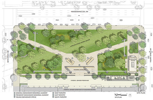
Eisenhower Memorial site plan. All images from NCPC.
Earlier this month, the National Capital Planning Commission (NCPC) released the latest Eisenhower plans, in preparation for a September 12 review meeting.
The proposed design will re-conceive the mess of turn lanes and parking lots where Maryland Avenue SW meets Independence Avenue as a lovely city square. From that perspective, the design is a great victory for DC.
Since the buildings around the memorial are generally uninteresting and devoid of activity, architect Frank Gehry has included several elements that will make the square function as a better and more interesting urban room.
 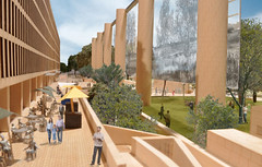
Tapestries form the border of an urban room (left), while an amenity-filled promenade helps draw people to the site (right).
Tall tapestries, covered with graphics, will surround and help frame the square, and will hide the eyesore buildings behind. Along the back edge, an activity-filled promenade will add an element of mixed-use, helping to draw more people. The promenade will include a sidewalk cafe, an art exhibition area, and a visitor center.
The memorial itself, at the center of the new square, will consist of stone blocks and metal statues arranged in a casual, informal plan. Like the FDR Memorial, it will be more introspective than monumental.

Central memorial.
The informal stone concept used at FDR and MLK has become popular because it works. Just about everyone likes it, and it doesn’t offend anybody. The same will likely be true for Eisenhower.
But I do wonder how many more similar memorials we can build before the idea becomes a cliche. Ironically, a classical alternative would be more daring.
Cross-posted at Greater Greater Washington.
August 29th, 2013 | Permalink
Tags: architecture, parks, urbandesign
National Harbor’s colossal never-built skyscraperNational Harbor was originally going to be called Port America, and it almost included a skyscraper that might have been taller than the Washington Monument.
By 2008 when the first part of National Harbor opened, the concept of suburban town centers was tried and true. But developers have been trying to build a town center there since the mid 1980s. When they started, it was the most progressive of ideas.
The original plan for Port America dates from 1987. It would have included a neo-classical mixed-use town center in the same place as National Harbor’s waterfront, plus a large office park on the adjacent property that is now under-construction to become an outlet mall.
The office park would have included a 52-story trophy office tower. It would very likely have risen above the 555-foot Washington Monument, and definitely would have dwarfed the DC region’s current tallest office building, Rosslyn’s 384-foot 1812 North Moore.
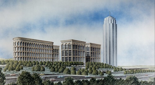 |
 |
 |
 |
| Port America. All images from Burgee-Jonhson. |
Cross-posted at Greater Greater Washington.
August 9th, 2013 | Permalink
Tags: development, history, urbandesign
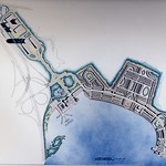
Fairfax still wants a real center at Vienna MetroWestDevelopers floated a plan last month to drastically downscale the town center at Vienna MetroWest, but Lynda Smyth, the county supervisor for the area, said she never approved such a change, nor would the Board of Supervisors likely ever do so. Developers say they’re still committed to the full town center, but can’t do it right away.
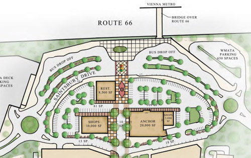
The downscaled proposal, with single-story buildings fronting onto parking lots. Image from Paraclete Realty.
Developers spoke with county supervisors and residents about the plans at a public meeting on June 18. According to resident Eric Bleeker, the room was packed, and many attendees came because they’d heard about the plan on Greater Greater Washington. Supervisor Smyth said she hadn’t seen the new proposal until it was posted to Greater Greater Washington, and would almost surely not approve it.
According to Tim Alexander of development firm Clark Realty, the downscaled proposal is supposed to be temporary. Clark still wants to build the full town center, but can’t find tenants for the originally proposed office buildings in the current economy. In the mean time, his company doesn’t want to leave that land empty for what could be years.
“The negativity to the plan was immense,” said Bleeker, who lives at MetroWest. “After a good verbal lashing from Supervisor Smyth, the Clark representative spoke of wanting to work with the county on alternative ideas, and threw out pop-up retail.”
What now?
Unfortunately, Clark is between a rock and a hard place. Plan A, the full town center, is impossible in the short term due to the economy. Plan B, the downscaled version, is rightly unpopular. What could work for Plan C?
It would be short-sighted to simply build residential towers in the town center instead of offices. MetroWest would lose its planned mixed-use character. It would be harder to keep retail spaces full over the long term with neither daytime workers in walking distance nor a lot of car traffic passing by.
So temporary single-story buildings may be the only viable near-term option, even if “temporary” means years. But if that’s the case, Clark should strive to build a bona fide main street, rather than a couple of retail pad sites, with half of them fronting onto parking lots.
Even if parking lots are necessary, the main strip of activity should be the pedestrian-oriented walkway down the middle of the site, leading to the Metro station. All stores should front directly onto the main street, and there shouldn’t be any gaps in the street wall where a parking lot comes right up to the front.
If the full town center is years away then a temporary single-story retail town center may be an unfortunate reality, but even if so, Clark can do better.
Cross-posted at Greater Greater Washington.
July 3rd, 2013 | Permalink
Tags: development, urbandesign
|
Media


Site
About BeyondDC
Archive 2003-06
Contact
Category Tags:
Partners
|


