|
Special Features


Image Libraries


|
|
Blog
This momentous weekend launched a new reality. The city, and our battles, are different now
Here we are. Donald Trump is America's president. The largest protest in American history greeted his first day. Welcome to Washington and the USA in 2017.
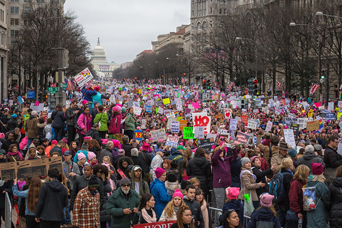
Saturday’s Women’s March. Image from Mobilus In Mobili on Flickr.
Our weekend was momentous
Two days, two gigantic events.
As inaugurations go, Friday's was noticably small. But even a small inauguration is big enough to change the tone of city life.
Security fences partitioned blocks of downtown, and an army of police forces dominated the streets. Many locals stayed away to avoid the logistical and emotional headaches. Parts of the city became eerily dead, while others burst with unusual life, as Trump supporters descended to hotels and tourist areas around the White House.
Washington became a foreign city, its own residents outsiders to a security and tourist project to which we didn't belong, nor feel healthy within.
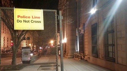
Security barriers in an empty downtown.
During the inauguration itself, Metro ran smoothly. Trump presented a bleak picture of America. Protests raged, mostly peacefully, sometimes not. GGWash's own David Whitehead proved that deescalation works.
The new administration erased climate change from presidential priorities, and disciplined the National Park Service for reporting meager crowds. Joe Biden took Acela home to Delaware.
We went to bed, unsure the country we would wake to find.
And then, on Saturday, three times more people attended the Women's March than Friday's inauguration. Nationwide, at least three million took to the streets.
There was grief and humor and defiance. Mayor Bowser chanted "Leave us alone!," DC police donned pink hats, and Metro had its second busiest day ever.
In contrast to Friday, Saturday's Washington felt more ours than ever. The city became strangely joyous, as march-goers spread over downtown and the National Mall to reclaim our public spaces, replacing the inauguration's fenced-off security apparatus with revelry lasting well into the evening.
We went to bed with renewed determination.
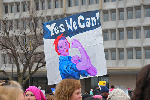
Image from Andrew Aliferis on Flickr.
Meanwhile, Donald Trump's press secretary brazenly lied, and his counselor hoped to replace the truth with "alternative facts" intended to sow uncertainty and estrange the media.
The policy fights are just beginning
Trump may be the most urban president in history, but his party and his base are vehemently anti-urban. Administration policy seems to be largely under the purview of Vice President Pence, whose small town Indiana roots are decidedly not urban.
They plan dramatic cuts to many federal departments, including the Department of Transportation, where multimodal infrastructure spending will likely decline in favor of tax breaks for construction firms. The Environmental Protection Agency is likely to be gutted, enabling a new round of urban pollution and ending the fight against climate change. HUD raised prices for first-time homebuyers within an hour of Trump's swearing-in. The Department of Justice will no longer pressure police departments over civil rights.
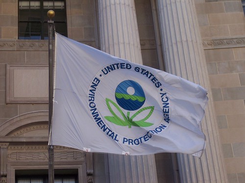
What will the EPA look like in four years? Image from Paul Fagan on Flickr.
Locally, such massive cuts and a proposal to strip benefits from government employees could throw Washington's economy into recession, as jobs bleed out of the city. Or security and military spending could lead to a new boom. Either way, Congress' small government Republicans will override local decision-making in DC.
Nationally, the right is emboldened, while the left is beginning to act like a true opposition.
So, here we are. Donald Trump is America's president. The future of our city and our country is uncertain. We face colossal challenges. But GGWash's mission and values are still worthwhile, and our community is as strong as ever. We'll be here.
 Comment on this at the version cross-posted to Greater Greater Washington. Comment on this at the version cross-posted to Greater Greater Washington.
January 23rd, 2017 | Permalink
Tags: economy, environment, events, government, in general, metrorail, The New America, transportation

How snow exacerbates the weaknesses of suburban road designA lot of people had awful commutes last night, thanks to snow. And a lot of people had fine ones. One explanation for the difference: Suburban roads are far more susceptible to catastrophic breakdown than urban street grids.
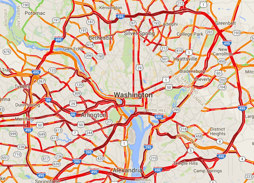
Traffic congestion on snow night. Image from Google.
Snow storms like last night’s highlight how easy it is to completely shut down suburban-style transportation systems. And conversely, how comparatively resilient are more urban systems.
Cities beat suburban areas on snow resiliency in two big ways: Multimodalism and network connectivity.
First and foremost, with transit, walking, and biking more convenient options, cities are simply much less reliant on having clear roads. Metrorail worked like a dream yesterday, and pedestrians had a lovely commute.
It simply didn’t matter how bad the roads got for a significant percentage of DC’s travelers, because they simply weren’t on the roads while they traveled.
Don’t put all your eggs in one basket
But that’s not all. Even for car drivers, urban street grids are more resilient than road systems focused around large highways, because of how they’re laid out.
The great thing about interconnected grids is that if one street becomes blocked, there’s another perfectly good street one block over. And another one block down.
If a wrecked car or fallen tree or whatever blocks the street you’re on, you just take a different street. There might be some additional turns involved; it might not be quite as direct. But for the most part 28th Street isn’t all the different from 29th Street.
Contrast that with suburban-style systems where all traffic in a particular area funnels onto one big highway. If that one highway becomes impassible, everyone in the area is stuck. Or, at best, they have to drive miles out of their way to find the next big highway.
This illustration shows how that works. If the “Collector Road” gets jammed, people in the top half of the image can still move around. People on the bottom half can’t.
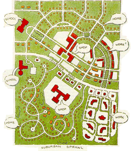
Suburban-style roads vs urban street grid. Image from USDOT.
That’s part of what happened last night. There were a lot of crashes. If they happened on arterial highways with no parallel roads, which a lot of them did, that road would succumb to gridlock.
Urban places aren’t immune, but they’re better off
To be sure, this storm was bad for roads all over the region.
Streets in Northwest DC were just as dangerous as those elsewhere, and DC’s plowing response was bad. And buses were every bit as stuck in it as cars.
But there’s no doubt that people who could travel via Metro or foot had a much better time, and there’s no doubt that drivers who could use parallel streets were able to bypass some of the congestion on arterials.
Comment on this at the version cross-posted to Greater Greater Washington.
January 21st, 2016 | Permalink
Tags: environment, master planning, roads/cars, transportation
Not building enough housing is morally equivalent to tearing down people’s homesAccording to the California housing champion who’s suing communities that don’t allow enough new development, not building needed density is morally equivalent to tearing down people’s houses.
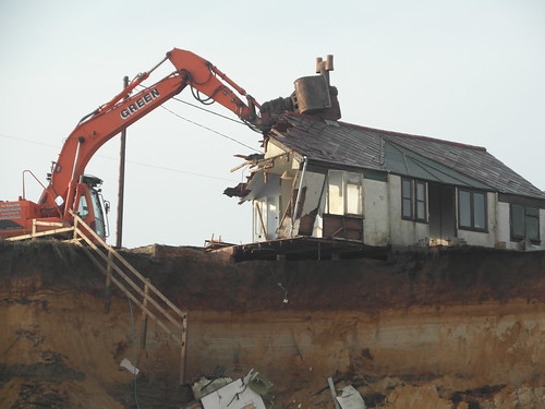
Photo by .Martin. on Flickr.
Sonja Trauss, founder of the SF Bay Area Renters’ Federation sums up the housing problem affecting nearly every growing American city today:
“Most people would be very uncomfortable tearing down 315 houses. But they don’t have a similar objection to never building them in the first place, even though I feel they’re morally equivalent. Those people show up anyway. They get born anyway. They get a job in the area anyway. What do they do? They live in an overcrowded situation, they pay too much rent, they have a commute that’s too long. Or maybe they outbid someone else, and someone else is displaced.”
Trauss hits the key points: The population is growing, and people have to live somewhere. If we refuse to allow them a place to live, that’s just like tearing down someone’s home.
Someone else is displaced
Trauss’ last sentence is particularly important. It explains how the victims of inadequate housing often are not even part of the discussion. She says “Or maybe [home buyers] outbid someone else, and someone else is displaced.”
Here’s how that works: One common argument among anti-development activists is that new development only benefits the wealthy people who can afford new homes. That’s wrong. It’s never the wealthy who are squeezed out by a lack of housing. Affluent people have options; they simply spend their money on the next best thing. Whenever there’s not enough of anything to meet demand, it’s the bottom of the market that ultimately loses out.
Stopping or reducing the density of any individual development doesn’t stop displacement or gentrification. It merely moves it, forcing some other person to live with its consequences.
Every time anti-development activists in Dupont or Georgetown or Capitol Hill reduce the density of a construction project, they take away a less-affluent person’s home East of the River, or in Maryland, or somewhere else. The wealthy person who would have lived in Capitol Hill instead moves to Kingman Park, the middle class person who would have lived in that Kingman Park home instead moves to Carver Langston, and the long-time renter in Carver Langston gets screwed.
As long as the population is growing, the only ultimate region-wide solution is to enact laws that allow enough development to accommodate demand.
Comment on this at the version cross-posted to Greater Greater Washington.
January 5th, 2016 | Permalink
Tags: development, economy, environment, law, preservation
Seven spectacular photos of last night’s stormy skyLast night’s heavy storm produced a truly breathtaking evening sky. Here are seven spectacular photos from around the region.
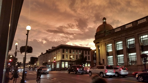
M street, Georgetown.
According to Capital Weather Gang, the storm washed pollutants from the air at exactly the right moment. The clear air combined with dramatic clouds and red light from the sunset to produce the memorable view.
> Read more
The rest of this post uses photos from the GGW Flickr pool. Therefore the full post only appears on Greater Greater Washington.
June 24th, 2015 | Permalink
Tags: environment, fun, galleries
Gas is suddenly cheap(er), and the reason is bigger than you think
|
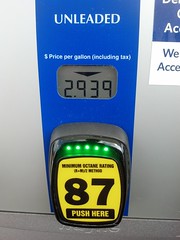
Photo by Wil C. Fry on Flickr. |
Gas prices have fallen below $3 per gallon in much of the US, and the explanation isn’t the simple seasonal differences that always make gas cheaper in autumn. The bigger reason: US oil shale deposits are turning the global oil market on its head.
How did cheap gas happen?
In the simplest terms, supply is up and demand is down.
Travel drops between the summer travel season and the holidays, and cooler fall temperatures actually make gas cheaper to produce. That’s why gas prices always fall in autumn.
But that’s not enough to explain this autumn’s decline, since gas hasn’t dropped this low in years. China is also using less gas than expected, but that’s also only part of the explanation.
The bigger explanation seems to be that supply is also up, in a huge way. North American oil shale is hitting the market like never before, and it’s totally unbalancing the global oil market. Oil shale has become so cheap, and North American shale producers are making such a dent in traditional crude, that some prognosticators are proclaiming that “OPEC is over.”
It’s that serious a shift in the market.
Will this last?
Yes and no.
The annual fall price drop will end by Thanksgiving, just like it always does. Next summer, prices will rise just like they always do. Those dynamics haven’t changed at all.
Likewise, gasoline demand in China and the rest of the developing world will certainly continue to grow. Whether it outpaces or under-performs predictions matters less in the long term than the fact that it will keep rising. That hasn’t changed either.
But the supply issue has definitely changed. Oil shale is here to stay, at least for a while. Oil shale production might keep rising or it might stabilize, but either way OPEC crude is no longer the only game in town.
Of course, oil shale herf=”http://www.businessweek.com/articles/2013-10-10/u-dot-s-dot-shale-oil-boom-may-not-last-as-fracking-wells-lack-staying-power”>isn’t limitless. Eventually shale will hit peak production just like crude did. When that happens it will inevitably become more expensive as we use up the easy to refine reserves and have to fall back on more expensive sources. That’s a mathematical certainty. But it’s not going to happen tomorrow. In the meantime, oil shale isn’t very scarce.
So the bottom line is that demand will go back up in a matter of weeks, and the supply will probably stabilize, but at higher levels than before.
What does this mean?
Here’s what it doesn’t mean: There’s never going to be another 1990s bonanza of $1/gallon fill-ups. Gas will be cheaper than it was in 2013, but the 20th Century gravy train of truly cheap oil is over.
Oil shale costs more to extract and refine than crude oil. Prices have to be high simply to make refining oil shale worth the cost, which is why we’ve only recently started refining it at large scales. Shale wouldn’t be profitable if prices dropped to 1990s levels. In that sense, oil shale is sort of like HOT lanes on a congested highway, which only provide benefits if the main road remains congested.
So shale can only take gas prices down to a little below current levels. And eventually increased demand will inevitably overwhelm the new supply. How long that will take is anybody’s guess.
In the ultimate long term, oil shale doesn’t change most of the big questions surrounding sustainable energy. Prices are still going to rise, except for occasional blips. We still need better sustainable alternatives. Fossil fuels are still wreaking environmental catastrophe, and the fracking process that’s necessary to produce oil shale is particularly bad. It would be foolish in the extreme for our civilization to abandon the progress we’ve made on those fronts, and go back to the SUV culture of the 20th Century.
There will probably be lasting effects on OPEC economies. The geopolitical situation could become more interesting.
In the meantime, enjoy the windfall.
Cross-posted at Greater Greater Washington.
October 28th, 2014 | Permalink
Tags: economy, energy, environment, roads/cars, transportation
Sneckdowns take over the streetsThe recent snow made for the best sneckdown spotting weather in DC since the term first entered our lexicon. Last week we put out a call for photos of sneckdowns in the wild, and plenty of you responded. Here are some of the best.

17th and Potomac Ave, SE. Photo by Justin Antos.
In the wonky world of urbanism advocacy, sneckdowns have gone viral. The term, referring to places where snow formations show street spaces cars don’t use, first popped up in New York. Since then it’s made headlines in Philadelphia, Chicago, Vancouver, and more.
It’s true that actual engineers shouldn’t design streets solely around piled snow, but certainly sneckdowns are a handy illustration of how we give too much pavement to cars.
Here are more local examples, sent in by readers.

14th St and Independence Ave, SW. Photo by @gregbilling.

M St and Jefferson St, NW. Photo by @gregbilling.

Rhode Island Ave and R St, NW. Photo by @MaryLauran.

Rhode Island Ave and Q St, NW. Photo by @MaryLauran.

4th St, NE. Photo by @TonyTGoodman.

Fairfax Dr and 10th St N, in Arlington. Photo by @guusbosman.

Greenbelt. Photo by msickle.
Thanks to everyone who sent in photos! Keep watching #dcsneckdown on Twitter for more.
Cross-posted at Greater Greater Washington.
February 18th, 2014 | Permalink
Tags: environment, roads/cars, transportation, urbandesign
Send us your sneckdown picturesNow that’s we’ve had a big snow in DC, send us pictures of sneckdowns you spot in the wild. You can tweet them with hashtag #dcsneckdown, or email them to us at
sneckdown@beyonddc.com. On Monday, Greater Greater Washington and BeyondDC will publish the best ones.

Sneckdown today in Southeast DC. Photo by Ralph Garboushian.
Sneckdowns are where snow formations show the street spaces cars don’t use.
GGW reader Ralph Garboushian sent us this one already. He describes it:
“Shoveling and plowing patterns in front of my house show how the intersection of Potomac Avenue, E Street & 18th Street SE could be made safer for both pedestrians and motorists. The current design is a disaster – I have seen several accidents at this intersection, including one that sent a car nearly into my front yard and another that took out a historic call box and nearly knocked down a utility pole. In addition, this intersection is right in front of Congressional Cemetery and on the way to the Metro and sees heavy pedestrian traffic.
The intersection’s poor design combined with motorists speeding down Potomac create a hostile and dangerous atmosphere for pedestrians. This intersection desperately needs traffic calming and these plow/shovel patterns illustrate how it could be done.”
We look forward to seeing more!
Cross-posted at Greater Greater Washington.
February 13th, 2014 | Permalink
Tags: environment, roads/cars, transportation, urbandesign
Map: How much snow does it take to cancel school?This map shows approximately how much snow it takes to cancel school in various parts of the United States.

Map from Reddit user atrubetskoy.
On Reddit, the map’s author explains the methodology:
[It’s from a] combination of a /r/SampleSize survey, City-data.com threads, NOAA maps and some other local news sources.
So while it may not be the most precise or reliable data, it’s still an interesting general look at snow closure patterns around the country.
Cross-posted at Greater Greater Washington.
January 30th, 2014 | Permalink
Tags: environment, maps
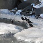
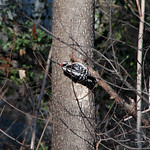
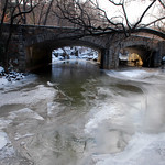
To see urban wildlife in the snow, find flowing waterDespite cities’ reputation as concrete jungles, most have a healthy collection of wildlife. Birds, rodents, deer, anything that can live on the margins of human activity. But what happens to that wildlife when the city is hit with winter weather?
With temperatures consistently below freezing, and even the mighty Potomac River frozen all the way across at points, wildlife is going to be looking for drinkable water. On Saturday, I dropped by fast-flowing Rock Creek to try and spot some. I wasn’t disappointed.
 |
 |
 |
 |
| A Northern Flicker (top), Starlings (bottom left), a Downy Woodpecker (bottom center), and my viewing spot near P Street Beach (bottom right). |
Cross-posted at Greater Greater Washington.
January 27th, 2014 | Permalink
Tags: environment, galleries
“Sneckdowns” reveal street space cars don’t useEvery time it snows, vast sections of city streets remain covered by snow long after plows and moving cars have cleared the travel lanes. These leftover spaces are called “sneckdowns,” and they show where sidewalks or medians could replace roads without any loss to car drivers.
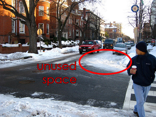
A DC sneckdown from the 2009 snow storm. Original photo by Rudi Riet on flickr.
The term sneckdown is a portmanteau of “snow” and “neckdown,” the latter being another term for sidewalk curb extensions. So it literally means a sidewalk extension created by snow.
Following the recent snow storm in New York, Streetsblog put out a call for photos of sneckdowns in the wild. They received plenty of responses.
Next time it snows here, be on the lookout.
Cross-posted at Greater Greater Washington.
January 8th, 2014 | Permalink
Tags: environment, roads/cars, transportation, urbandesign
|
Media


Site
About BeyondDC
Archive 2003-06
Contact
Category Tags:
Partners
|


