|
Special Features


Image Libraries


|
|
Blog
Fairfax’s answer to neighbors’ transit plans: Light rail, streetcars, and BRTNot to be outdone by its neighbors’ aggressive plans for rail and BRT networks, Fairfax County has an impressive transit plan of its own.
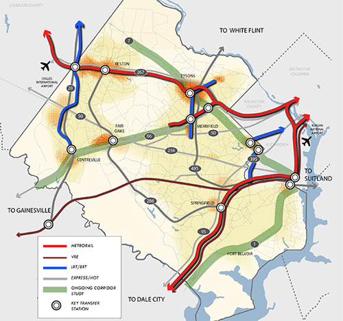
Fairfax County’s proposed high quality transit network. Image from Fairfax.
DC has its streetcar and moveDC plans, Arlington and Alexandria have streetcars and BRT, and Montgomery has its expansive BRT network, plus of course the Purple Line.
Now Fairfax has a major countrywide transit plan too, called the High Quality Transit Network.
Fairfax’s top priorities are to finish the Silver Line and the Bailey’s Crossroads portion of the Columbia Pike streetcar, but that’s not the end of their plans.
County planners are also looking at several other corridors, including Route 1, Route 7 (both east and west of Tysons), I-66, Route 28, and Gallows Road/Dolly Madison Boulevard.
Both rail and BRT are possibilities for all those corridors. Some may end up light rail or streetcar, others bus. Route 1 and I-66 could even include Metrorail extensions.
In addition to all that, Fairfax County Parkway is slated for HOT lanes, which could make express buses a more practical option there.
As the DC region continues to grow, and demand for walkable, transit-accessible communities continues to increase, these types of plans are crucial. If our major arterial highways are going to become the mixed-use main streets of tomorrow, transit on them must significantly improve.
Fairfax is undeniably still spending a lot on bigger highways. Planners’ inability to calm traffic on Routes 7 and 123 through Tysons, for example, indicates roads are still priority number one. But it takes a plan to change, and this is a strong step forward. So good on Fairfax for joining the club.
 Cross-posted at Greater Greater Washington. Cross-posted at Greater Greater Washington.
April 22nd, 2014 | Permalink
Tags: BRT, land use, lightrail, master planning, metrorail, roads/cars, streetcar, transportation

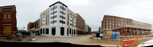
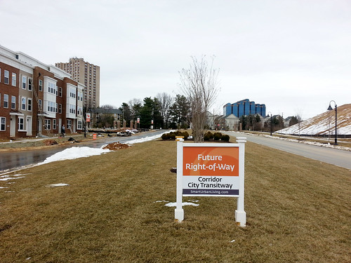
Construction progress at Gaithersburg’s two new town centersGaithersburg’s collection of walkable new urbanist neighborhoods is growing, with impressive construction progress at both the Crown development and Watkins Mill Town Center.

Ellington Boulevard in Downtown Crown, seen from the north.
Both neighborhoods are planned around future stations of the Corridor Cities Transitway, which will someday connect a whole string of walkable neighborhoods in upper Montgomery County to Shady Grove Metro station. But with rapid transit service still years away, construction is working from the outside in, focusing first on sections farther from planned transit stations.
Crown
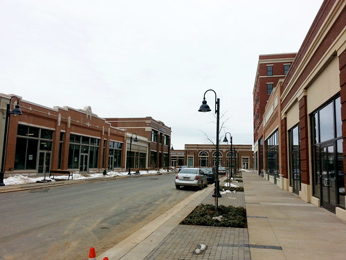
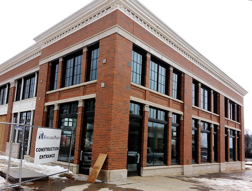
At the Crown development, construction progress is focused on Phase 1, the western half. A mixed-use town center surrounds the corner of Ellington Boulevard and Crown Park Avenue, with blocks of rowhouse neighborhoods to the side.
Ellington Boulevard, seen from the south.
Crown Park Avenue, perpendicular to Ellington Boulevard.
It’s clear that serious work and expense went into the architectural details.

Downtown Crown.
Downtown Crown.
To the east, the rowhouse neighborhoods are taking shape as well.

Rowhouses on Hendrix Avenue.
Decoverly Drive marks the boundary of Phase 1, as well as the future route of the transitway. Crown’s original plans show an even larger town center surrounding the BRT station along Decoverly. But following actual construction, it appears density has been reduced around the station, and rowhouses line the Phase 1 edge instead.
One wonders if Phase 2 will make Crown a truly transit-oriented place, or if transit will merely run through it.
Decoverly Drive.
Watkins Mill Town Center
A few miles to the northwest, adjacent to the Metropolitan Grove MARC station, Watkins Mill Town Center is taking shape.

Watkins Mill Town Center.
At Watkins Mill, the rowhouses and lower density portions are nearing completion, but the downtown section has yet to begin construction. As a result, a huge field separates the MARC station (and future BRT stop) from the constructed portions of the development.
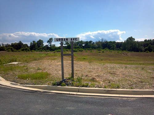
Urban Avenue, not quite urban yet.
Someday, the Corridor Cities Transitway could make Gaithersburg a second Arlington, a string of walkable communities knit together by transit. Whether that actually happens or not will depend the State of Maryland getting the transitway built, and the City of Gaithersburg insisting on truly transit-oriented places.
Cross-posted at Greater Greater Washington.
February 24th, 2014 | Permalink
Tags: architecture, BRT, development, master planning, transportation
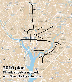
MoveDC calls for more transit, dedicated lanesIn the latest draft of DDOT’s MoveDC plan, the 37-mile streetcar network originally planned in 2010 becomes a 69-mile “high capacity transit” network.
The new 69-mile network would include DC’s initial 22-mile streetcar system, plus 47 more miles of either streetcar or BRT.
 |
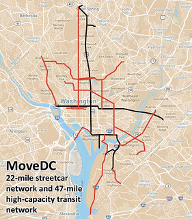 |
| 37-mile network from 2010, and latest MoveDC 69-mile proposal. Base maps from Google. |
The 47-mile network, shown in red on the map, would include 25-miles of dedicated transit lanes, regardless of whether those lines are eventually built as bus or rail. The dedicated lanes would be on 16th Street, North Capitol Street, I-295, M Street SE & SW, and I and H Streets downtown.
Curiously, the proposed streetcar line on Rhode Island Avenue from the 2010 plan isn’t carried forward into MoveDC.
The new plan shows the 14th Street streetcar shifting over to 7th Street, although the details of that line are still in flux. It could still end up on 14th.
Finally, MoveDC also notes several potential extensions to Maryland and Virginia, anywhere a proposed DDOT line approaches the District boundary. Perhaps most notably, there are potential connections across Long Bridge into Arlington, down I-295 to National Harbor, and to Silver Spring.
For Metrorail, MoveDC includes WMATA’s proposal for a new loop subway line through DC, connecting Rosslyn on one end and the Yellow Line bridge on the other.

Map from BeyondDC, using base map from Google.
Overall this is a progressive and ambitious proposal, although the removal of Rhode Island Avenue raises questions. It’s still a draft, so you can comment via the WeMoveDC website.
Cross-posted at Greater Greater Washington.
November 22nd, 2013 | Permalink
Tags: BRT, master planning, streetcar, transportation
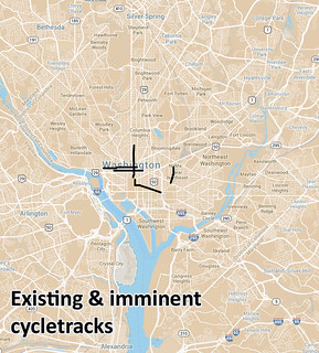
MoveDC plan proposes 70 miles of cycletracksDC could one day have 70 miles of protected bike lanes, if the latest proposal from DDOT becomes reality.
The proposal comes as part of the latest draft of MoveDC, DDOT’s master plan. It’s still only a proposal, and has not been approved by the DC Council. But what an exciting proposal it is!
 |
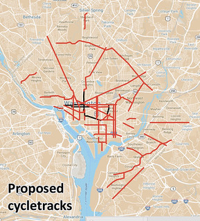 |
| Existing & proposed DC cycletracks. Base map from Google. |
And that’s not all, just for bikes. The proposal also includes over 60 miles of new off-street trails, and another 70 miles of new regular bike lanes.
Of course, it’s easy to adopt great plans and harder to accomplish them. DDOT is still struggling to implement the M Street cycletrack, after all. But one must start with a plan, and this appears to be an extremely progressive plan.
Tomorrow I’ll share the latest recommendations for transit.
Cross-posted at Greater Greater Washington.
November 21st, 2013 | Permalink
Tags: bike, master planning, transportation
NCPC will likely recommend tweaking DC height limit
|
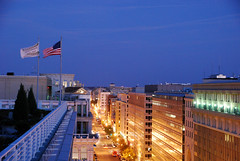
Downtown DC. |
The National Capital Planning Commission (NCPC) study considering whether or not to raise DC’s height limit is unlikely to recommend major skyline-altering changes. But it will suggest tweaking the rules to add more flexibility, and leaves open the possibility of taller buildings outside downtown.
In his report to NCPC, executive director Marcel Acosta will recommend against raising the height limit significantly downtown, but will suggest changing the rules regarding rooftop penthouses.
The rules currently allow unoccupied mechanical-only penthouses to breach the height limit by a few feet in certain situations. Acosta will propose allowing active human use of those spaces.
Acosta will also recommend that NCPC further consider raising the height limit for areas outside downtown, where the impact on the monumental core would be negligible. That might allow places like Anacostia or Tenleytown to develop along more similar lines to Arlington and Bethesda.
The NCPC will vote on an official recommendation in November, after hearing Acosta’s report and gathering public feedback. Following that, Congress will have the power to either pass a bill making changes, or retain the status quo.
Cross-posted at Greater Greater Washington.
September 11th, 2013 | Permalink
Tags: master planning, urbandesign
Montgomery rethinks Bethesda Purple Line stationThe Bethesda Purple Line station is currently planned to squeeze into an existing tunnel below Bethesda’s Apex Building. But planners are now considering an alternate plan to tear down the Apex Building and redevelop the entire site.
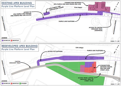
Existing plan (top) and alternate proposal (bottom). Images by Maryland MTA.
Between Silver Spring and Bethesda the Purple Line will run on land from a former railroad line. Years ago the railroad sold the development rights above the tracks in downtown Bethesda. Now there are two buildings atop the rail corridor, the Apex Building and the Air Rights Building.
The Purple Line will pass easily under the Air Rights Building, but the Apex Building needs to accommodate a station. And while the tunnel there was designed to carry tracks, it wasn’t originally built to hold a station. The structural columns supporting the building come down into the rail tunnel, severely constraining the space.
Planners can squeeze a station in the existing space, but the result is a narrow platform crowded with building columns.
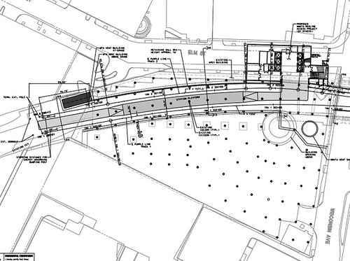
Apex Building column layout. Image by Maryland MTA.
Meanwhile, there are other problems with the existing arrangement. There’s not enough room in the tunnel for both a light rail station and a bike trail, so the trail is planned to be moved to the surface.
Also, building a subway station under the Apex Building would complicate any potential future redevelopment prospects. Since the Apex Building is only 5 stories tall, it’s already shorter than most other buildings nearby, and it will become a prime redevelopment candidate after Bethesda becomes a key Purple Line / Red Line transfer point.
Redeveloping now could solve the problem
The new proposal suggests tearing down the Apex Building, building the Purple Line station in a new custom-built trench, adding a 2nd tunnel for the trail, and then allowing the owners of the Apex Building to replace it with a bigger building.
Montgomery County is currently in talks with the owner of the building, and is working through a minor master plan amendment to determine the density and height.
If the new plan is approved, all the pieces will work together better. The Purple Line station will be simpler and more spacious, bike riders will have an uninterrupted dedicated trail, and one of the most transit-accessible properties in Montgomery County can be redeveloped at a more appropriate density.
It would be win/win/win.
As long as this doesn’t delay the rest of the Purple Line, I say let’s do it.
Cross-posted at Greater Greater Washington.
September 10th, 2013 | Permalink
Tags: development, lightrail, master planning, transportation, urbandesign
Baltimore’s suburban downtowns emerge as more urban
|
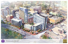
Towson Row. Image from Baltimore County. |
Bethesda, Silver Spring, and Arlington are some of the best suburban downtowns in America. Baltimore’s suburbs, by comparison, have lagged behind. But with large infill projects coming to Towson and Columbia, Baltimore’s most walkable suburbs may soon catch up with DC’s.
In Towson, 1500 new residential units have opened in the past 4 years, with the largest redevelopment, Towson Row, announced just last week. The change has been enough that the Maryland Transportation Administration is now considering a Towson circulator bus network.
Columbia has further to go. Towson at least has a traditional grid of streets around which to build. Columbia, by comparison, was planned in the mid-20th Century around a mall. All Towson really needs is more buildings; Columbia must be reworked from the ground up.
|
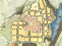 Downtown Columbia master plan. Image from Howard County. Downtown Columbia master plan. Image from Howard County. |
But they are getting there, slowly. In 2010 Howard County adopted a master plan to make downtown Columbia more urban. And now, actual projects are in the works.
Developers are moving forward with a 9-story infill project after plans for a 22-story one on the same property fell through. The shorter project is actually denser. It will have 160 apartments, 12,000 square feet of retail, and 130,000 square feet of office space, compared to 160 apartments, 11,000 square feet of retail, and no office space in the 22-story version. The 22-story tower was proposed nearly 10 years ago, and was a more suburban design.
Unfortunately, for the foreseeable future both Towson and Columbia will continue to lack an important piece of the urban puzzle: regional transit. DC’s suburban downtowns have the advantage of Metro, but Baltimore’s Metro is smaller, and serves neither Towson nor Columbia. Long range plans call for an eventual light rail connection to both places, but that’s decades away.
Cross-posted at Greater Greater Washington.
June 25th, 2013 | Permalink
Tags: bus, development, lightrail, master planning, transportation
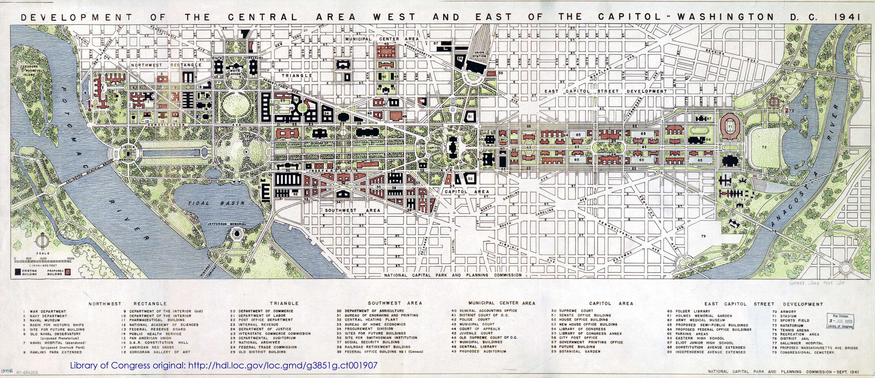
1941 DC plan shows east Mall, no I-395DC’s 1941 master plan is available through the Library of Congress. Published just months before Pearl Harbor, the plan is a fascinating look at the future pre-war planners envisioned.
The National Mall extends eastward to the bank of the Anacostia and dominates the plan. “Semi-public buildings,” parking garages, and much more highway-like Constitution and Independence Avenues line the new Mall. On the other hand, Southwest retains its historic street grid, and isn’t cut off by I-395.
What else jumps out?
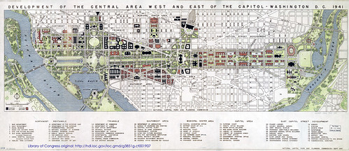
Image by National Capital Park and Planning Commission.
Cross-posted at Greater Greater Washington.
May 9th, 2013 | Permalink
Tags: history, master planning, parks, roads/cars, transportation
Richmond maps out a better transit networkRichmond has the bones of a good city. It’s small, with only a million people in its whole metro area, but it has a relatively large downtown and some very high quality urban neighborhoods. What it lacks is a transit system to match. The city’s new transportation plan aims to fix that.
Richmond’s bus system currently carries about 35,000 riders per day, total, for the whole region. That’s about the same as the Fairfax County Connector, and less than half of the 90,000 or so that Montgomery County’s Ride-On carries each day. Richmond could get so much more out of transit.
And now, it looks like they’re moving in that direction. The City of Richmond is drafting a new multimodal transportation plan. It builds on existing plans for a BRT line on Broad Street to propose a whole network of priority transit corridors. These would essentially be high quality surface bus routes, like WMATA’s 16th Street line. Not rapid, but not bad.
In addition to Broad Street BRT, the plan calls for 4 other priority bus lines, including one on the important Main Street / Cary Street corridor.
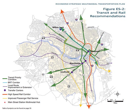
Richmond transit plan.
The draft plan also identifies bike improvements. Richmond is a natural biking city. It’s dense and walkable, and the urban areas are small enough that it’s easy to get to them all with a bike. Among proposed improvements, the plan calls for a bikesharing network, and identifies locations for cycle tracks.
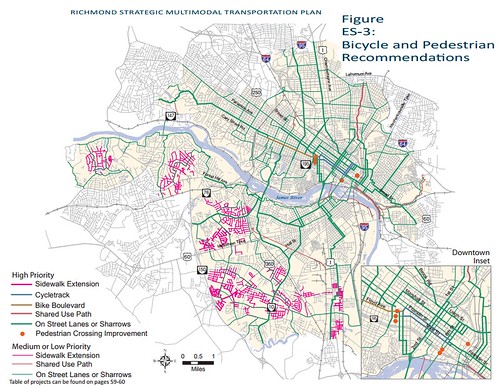
Richmond bike/ped plan.
Right now Richmond doesn’t have enough non-car transportation options. Even though the land use is already there to support multimodalism, most people rely on cars for most trips. Hopefully these proposals become reality, and transportation choice becomes more practical.
Cross-posted at Greater Greater Washington.
April 10th, 2013 | Permalink
Tags: BRT, bus, master planning, transportation
Growing Baltimore might get more TOD and a fancy train shedBaltimore’s decades-long population decline has officially reversed. The city grew by about 1,100 people last year. Congrats to Baltimore!
In more specific but also exciting news, Amtrak has adopted a new master plan for Baltimore’s Penn Station. It includes significant new development around the station, and a new canopy over the tracks that would dramatically improve the rider experience.
The plans are conceptual, and will have to go into greater detail before development can begin.
Concept plan for Penn Station. Image by Beatty Development.
March 15th, 2013 | Permalink
Tags: architecture, commuterrail, demographics, intercity, master planning, transportation
|
Media


Site
About BeyondDC
Archive 2003-06
Contact
Category Tags:
Partners
|


