|
Special Features


Image Libraries


|
|
Blog
The Post’s ironic ‘Drive Bye’ article
|

This guy doesn’t understand today’s youth. Surprise! |
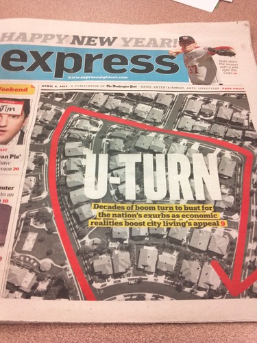
The fact that young people today are giving up cars in record numbers has become a fairly common meme lately. It’s a good story, being such a tremendous shift in the American Dream.
So I was not surprised to see today’s Express cover story on the issue, which also appeared in the full Washington Post. But I did laugh when I got to the end of the story. It’s a perfectly good piece, but it closes with some nay-saying from a professor Michael Marsden, of Saint Norbet College. He says:
“If you look at Main Street America on weekends, they’re still driving up and down Main Street… Are we really ever going to get over the love affair? I doubt it. Automotive culture, that love affair is a deep one. And we may have to compromise, we may have to shift, we may have to redefine it, but it’s a pull. It’s a deep, deep pull.”
I’d never heard of professor Marsden or Saint Norbet College, so I looked them up. I won’t speculate on his precise age, but it’s clear from the picture that he’s firmly a member of one of the generations that viewed cars as a symbol of freedom rather than a burden. Meanwhile, Saint Norbet is located in a suburb of Green Bay, Wisconsin, which can hardly be described as a major participant in America’s urban renaissance.
So let me get this straight: An old person in a suburb of a small, remote city isn’t impressed by the trends of today’s urban youth.
Surprise!
I don’t mean to pick on professor Marsden. I’m sure he’s a lovely man. And of course, it’s extremely unlikely that cars will ever disappear entirely. They’re wonderfully useful tools, after all. But I wonder if Marsden knows that his statements aren’t really a defense of car culture so much as they are further illustration of the generation gap. What better proof could the Post have shown than to end a story filled with quotes from young people with one from an old guy about how he thinks they’re all wrong?
May 22nd, 2012 | Permalink
Tags: The New America

Who would have guessedWho would have guessed, as recently as the late 1990s, that this could be the cover of a relatively major newspaper? And who would have guessed that the story would be so familiar that you don’t even have to read it in order to know what it says – gas prices, recession, never-ending congestion…
Clearly things have changed.
April 6th, 2012 | Permalink
Tags: The New America
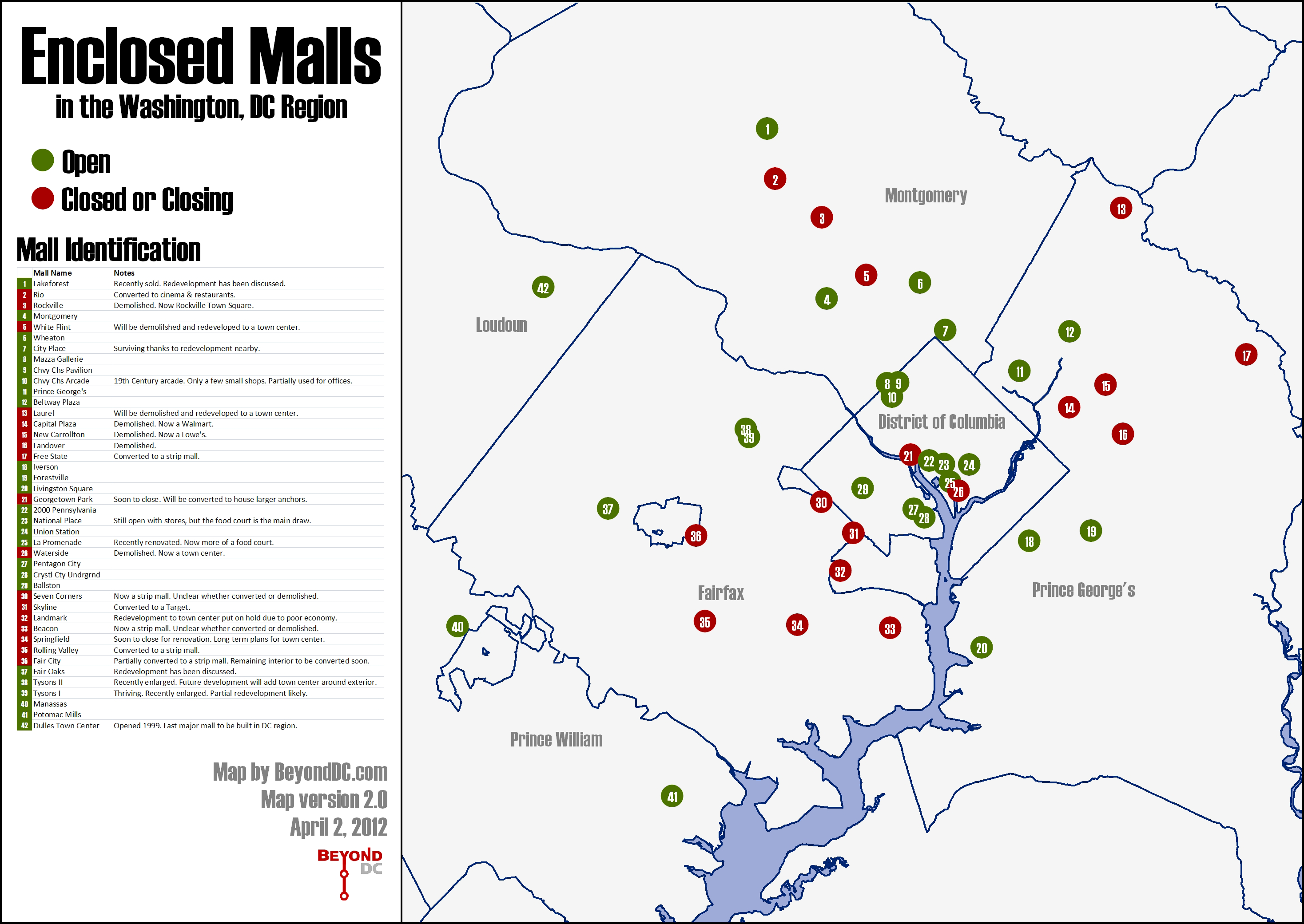
Updated closed malls mapI got a lot of useful comments on the closed mall map posted last week, both here and in the GGW thread. I’ve incorporated them into a second, improved draft.
The new & improved map.
The comments generally fell into two categories: questions about the definitions, and malls that should be added to the map.
Definitions:
For the purposes of this map, an “enclosed mall” is defined as a shopping center in which there is a row of small retail shops that are primarily accessed by pedestrians via an interior walkway. The two key components are small shops and an interior walkway. Buildings with interior spaces that consist primarily of large format retailers (such as the Pentagon Centre or DCUSA) are not malls for my purposes. Neither are spaces that are primarily food courts. Basically, to qualify as a mall for this map, a shopping center should have a space that looks generally like this.
Additions and subtractions:
This second draft includes the following malls that were left out of the first: La Promenade (DC), Waterside (DC), Free State (Bowie), Livingston (Ft Washington), Chevy Chase Pavilion (DC), National Place (DC), Beacon Mall (Mount Vernon), 2000 Pennsylvania Ave (DC), New Carrollton Mall (New Carrollton), Centre at Forestville (Forestville), Rolling Valley Mall (Burke).
The only mall subtracted from the original map was Virginia Square, which had a department store but apparently never an enclosed row of smaller shops.
I removed references to “thriving” and “surviving” from the table in the legend, since that was subjective and unclear.
Notable omissions:
Shopping centers that could be considered malls but that don’t meet the definition I used for this map include DCUSA, Old Post Office Pavilion, Gallery Place, Pentagon Centre, and the terminals at National and Dulles airports. The airports might technically meet the definition, but they’re obviously a different animal.
April 2nd, 2012 | Permalink
Tags: featured post, The New America
Enclosed malls fade from Washington regionOnce the economic juggernaut of suburbia, enclosed malls are slowly dying all across America. The Washington region is no exception.
This map shows 31 enclosed malls in the DC area, color-coded by status: green for malls that are still open, and red for malls that are closed or in the process of closing.
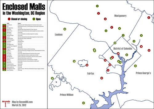
The 31 malls on the map range from small local ones like Fair City in Fairfax, to gargantuan super-regional ones like Tysons Corner. The only requirement to be on the map is that malls contain a common interior hallway lined with several shops.
Some, like Pentagon City, are chugging along as healthily as ever. Others, like Seven Corners Center, have been gone for years. Overall, more than 40% of the dots are red.
The reasons malls have closed vary as much as the malls themselves. Some closed because they were housed in cheap buildings that simply reached the end of their intended lifespans, while others couldn’t compete with the mixed-use town center developments that have become common in recent years.
Geography seems to be unimportant in whether a mall lives or dies. Red dots permeate all corners of the map, regardless of the wealth of the jurisdiction.
One thing that does seem to make a difference is size. Larger malls that draw from a wider area generally seem more likely to thrive than smaller ones. As the years go by and even more green dots turn to red, it’s likely the last hold outs will be the biggest and most famous.
Is this map comprehensive? Did I miss any malls? Let me know in the comments.
 Cross-posted at Greater Greater Washington. Cross-posted at Greater Greater Washington.
March 27th, 2012 | Permalink
Tags: featured post, The New America
Transit starts show we’re making progressIt wasn’t too many years ago that transit was an afterthought in the United States. For years at a time in the latter half of the 20th Century only a handful of US cities were actively building new transit lines at any given time.
But as this map from national transit blog The Transport Politic shows, the times, they’re a-changin’.
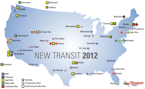
Major transit openings and construction starts planned for 2012.
Image by Yonah Freemark on The Transport Politic.
The map was published as part of an extensive post that lists every major transit line in the US that will either open or be under construction in 2012.
The list is impressive. Nearly every major metropolitan area in the country is represented, and even more would be if the list included projects in the planning stages but not yet slated to begin construction.
The listed projects range from the gargantuan to the mundane. From New York’s Second Avenue subway, to a BRT line in Fort Collins, Colorado.
The three map icons next to Washington indicate DC’s streetcar projects and the two phases of the Silver Line. Other local projects, such as the Purple Line, the Columbia Pike streetcar, and the Corridor Cities Transitway, aren’t shown because they are still in planning.
Our country still has a long way to go before the decades of automobile-focused planning are fully repaired. Even this list, impressive as it may be, is short compared to the highway construction list from most individual states. But still, we’re making progress as a country. We’re doing things now that we weren’t doing a few decades ago. Transit is reaching more people, in more places.
So let’s congratulate ourselves for a solid step forward. But let’s not be too happy; there’s still much work to be done.
Cross-posted at Greater Greater Washington.
January 4th, 2012 | Permalink
Tags: BRT, commuterrail, lightrail, metrorail, streetcar, The New America, transportation
The Millennial generation says no to suburbs88% of the Millennial generation wants to live in an urban setting, according to a survey reported on by the Wall Street Journal.
That’s a staggering statistic, with equally staggering implications. There are 80 million Millennials in the United States, which means that even ignoring all other demographics there is an existing market of 70 million people who want to live the urban lifestyle in this country. 70 million! That’s more than the total population of France. It’s five times the combined population of the cities of New York, Chicago, San Francisco, Philadelphia, Boston, and Washington (generally considered to be the six most urban in the US).
It means there’s an absolutely tremendous unmet demand for urban living in this country, and that there’s an equally tremendous oversupply of suburban homes. It means that it is time to rethink how we define the American Dream.
Some naysayers may suggest this is a blip, that young people have always liked cities, but once they start having children they’ll abandon them for the ‘burbs just like their parents. I dispute that. I don’t intend on leaving my future children trapped in a house that’s only accessible by car, with nowhere to go and nothing to do except play video games and get high. But that’s beside the point. Even if the naysayers are right, there will still be a revolving door of scores of millions of Americans who want to live the urban life.
This is a big deal, no ifs ands or buts about it.
January 14th, 2011 | Permalink
Tags: The New America
The generation divide, put simplyMuch has already been penned about the competing interests of Washington’s urbanist groups. Specifically, about the Committee of 100 with its preservationist bent versus the blogosphere and its smart growth bent, led by Greater Greater Washington.
I’ve thought about the divide as well, and I agree with those who say that it’s the result of a massive divergence in how the older generation and younger generation think about cities.
The Committee of 100 and its preservationist brethren think about cities in terms of the mid-to-late 20th Century, when proposals for massive highway and urban renewal projects threatened to essentially bulldoze most of the city and turn it into a giant suburb. Fighting those proposals was the necessary urbanist agenda of the day, and current residents owe preservationists a great thanks for saving our city from the wrecking ball decades ago.
But the experience of fighting a never-ending rear-guard action against bad ideas left that generation neurotic about new development. The city spent so long building crap that the preservationist contingent simply can’t wrap its mind around the possibility that change might be good. 50 years of mostly horrible, anti-urban development has convinced an entire generation that all new development must be bad.
Then there’s the new order. The younger generation of which I am part. Unlike the older generations that watched livably urban cities empty out, my generation started with empty cities and has watched them fill back in. The crap of the late 20th Century is what we were born in to. It’s our starting point. Since then, almost every change to the city has been for the better. Neighborhoods have revitalized, ghettos have disappeared, transit options have expanded. The city is a far better place now than it was when my generation first started paying attention in the early 1990s, so we’re comfortable with change. We think of it as a positive force. We want more of it.
Thus the great divide. One generation’s experience tells it that change must be negative, and another generation’s experience tells it the opposite.
Only time will tell if we’ll be able to find common ground.
November 19th, 2010 | Permalink
Tags: preservation, social, The New America
The idea of ‘mainstream’ has changedA recent survey finds that 60% of east coast residential developers are shifting away from the suburban detached house model and towards the mixed-use urban model. Essentially, they are building less auto-oriented sprawl and more walkable infill.
This is great, and in some ways shocking news. It wasn’t very long ago that nobody was interested in building anything but 20th Century suburbia, and those few who were interested couldn’t get zoning approval or bank financing to do it. The fact that a majority of developers are both interested in and capable of building urban products really speaks to how far we have come in the field of city building since the early experiments in New Urbanism during the 1980s.
Good work, America. Maybe there’s hope for us yet.
October 6th, 2010 | Permalink
Tags: economy, The New America
Interesting things from TPB
|
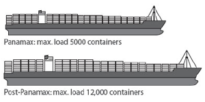
Much larger ships will soon be able to sail through Panama, increasing traffic at east coast ports. |
I live-tweet the monthly meeting of the Transportation Planning Board. This month there were a number of items that I think folks might like to see in more-than-140-character detail:
- The Board reviewed and accepted the first-ever National Capital Region Freight Plan (pdf), which discusses rail and trucking issues in the region. When the Panama Canal expansion project is completed in 2015, it will dramatically expand the tonnage of material shipped to east coast ports from Asia, which in turn means the amount of freight carried inland from ports like Norfolk and Baltimore will dramatically expand as well. To deal with this expected increase and still accommodate passenger rail, regional rail providers are working to expand their capacity any way they can. These strategies are discussed in the report.
- Each year the TPB provides a series of planning grants to local jurisdictions aimed at improving the connection between transportation and land use. This year the Board approved 8 projects (pdf), listed below:
- Van Ness Metro access and commercial corridor enhancement
- Best practices in providing concurrent bicycle and streetcar facilities in the same corridor
- Pedestrian facility standards for mixed-use developments in Prince William County
- Integrating freight rail with other land uses in Frederick
- Potential TOD scenarios for the US 29 / Cherry Hill area of Montgomery County
- Prince George’s County Central Avenue TOD scenarios
- Naylor Road Metro accessibility
- Safe walkways to transit in Rockville
- The Board received a briefing about the state of the commute survey (pdf), a study of commuting trends in the DC area. The survey presentation includes a lot of interesting information and is worth skimming. I’ve republished one page from it below. The implication that transit mode share is rising regionally is certainly a very significant piece of information.
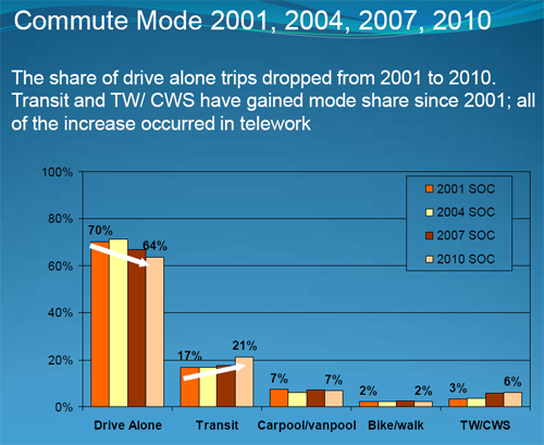
Regional commuter mode share over time.
Click the image to download the presentation.
July 21st, 2010 | Permalink
Tags: environment, master planning, The New America, transportation
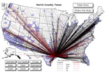
Where people moved in 2008The latest Cool Thing sweeping the net is this mapping website that shows domestic county-to-county migration patterns during 2008. That is, it shows you where people in the US moved to and from that year.
Click on any county in the United States and the map will display lines indicating where residents of that county moved to or from. Black lines indicate net inward movement (people moving into the county), red lines net outward movement (people moving out of it).
Some interesting results are below.
The District of Columbia:
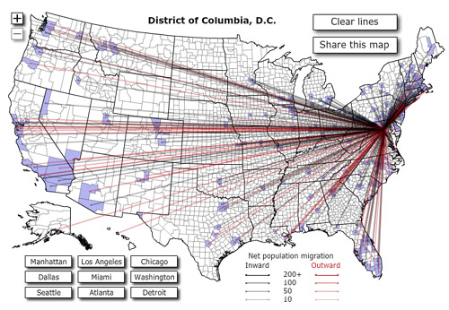
A lot more black than red is good news; it means more people are moving in than out. Geographically the ins and outs are fairly evenly distributed, although it’s clear enough that more people are coming from the north and leaving for the south and west.
DC area suburbs:
From left to right, Montgomery County, Prince William County, Arlington County.
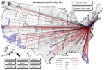 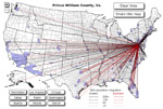 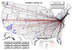
Interesting that from the perspective of black-to-red ratio, inner suburb Arlington is doing a whole lot better than outer suburb Prince William, with relatively comparable numbers of movements. Montgomery’s map is denser with both red and black, it being such a larger jurisdiction, but it is clear that even wealthy MoCo isn’t doing as well as the District.
Other cities:
From left to right, Los Angeles, Houston, and Cumberland, MD.
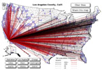  
Except for a solid influx from the northeast, LA is bleeding just about everywhere; is it time to start calling what’s going on the California diaspora? The map for Houston on the other hand is a mirror-image, covered in oily black. Smaller cities and rural areas obviously have less movement of both sorts, but isn’t it interesting that long-suffering Cumberland has as much black as red, and that its population gains are coming from the very suburban areas that were responsible for draining it in past decades?
This is yet more proof that the 20th Century model of municipal winners and losers is becoming increasingly obsolete. The south still grows at the north’s expense, but California isn’t paradise any longer. Meanwhile, central cities and an increasing number of small towns are more than holding their own against sprawl.
There are no two ways about it: The 21st Century is going to be different than the 20th.
Cross-posted at Greater Greater Washington.

A modified version of this post appeared on the Washington Post Local Blogging Network.
June 16th, 2010 | Permalink
Tags: The New America
|
Media


Site
About BeyondDC
Archive 2003-06
Contact
Category Tags:
Partners
|