|
Special Features


Image Libraries


|
|
Blog
Virginia’s answer to DC streetcar plan
|
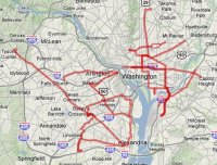
Consolidated inside-the-Beltway streetcar / BRT plan.
Click for Google Maps version. |
Plans for streetcars in DC and along Arlington’s Columbia Pike are well-known around the region, but they’re not the only exciting plans for new surface transit inside the Beltway. Arlington, Alexandria and Fairfax have quietly identified a number of corridors for significantly enhanced transit service.
Arlington:
The Transit Element of Arlington’s Master Transportation Plan identifies a “Primary Transit Network” of corridors in which the County wants to “encourage a low auto-usage lifestyle” by providing streetcar or BRT service with high frequency at all times of day. In addition to Columbia Pike, the PTN includes the Crystal City / Potomac Yard transitway, which Arlington wants to be a streetcar, as well as Lee Highway (US-29), Clarendon Boulevard, and Glebe Road. Presumably Arlington will focus on the latter three corridors once its plans for Columbia Pike and Crystal City are complete.
Alexandria:
The most prominent feature of Alexandria’s Transportation Master Plan is that the City identifies three “Priority Transit Corridors” on which they specifically propose to implement fully dedicated, no-cars-allowed, transitways. These transitways could be light rail or BRT, and are along US Route 1 (extending the CC/PY transitway), Duke Street, and Beauregard / Van Dorn.
Fairfax:
The recently released Fairfax County Transit Development Plan calls for three “streetcar or BRT” corridors: Columbia Pike, Route 7 and Route 28. Columbia Pike is simply the western segment of Arlington’s streetcar project. Route 7 is gaining momentum as a light rail corridor thanks to Congressman Moran. Route 28 (which is well outside the Beltway) appears to be a more distant goal.
Unfortunately, localities in Northern Virginia don’t control their transportation budgets to the same extent that DC (which is a state equivalent) does. While DDOT can fund and build streetcars directly, Northern Virginia localities currently lack the constitutional authority to adequately fund their own projects, and therefore have to work with Virginia’s state-level agencies to do so. This means Virginia won’t be able to move as fast as DC, and can’t be as up-front about determining streetcar versus BRT. Ultimately, these plans for Virginia are less secure than DC’s. Nonetheless, taken as a whole the plans that have come together for increased priority transit in Northern Virginia are extremely impressive, and would rival DC’s streetcar system if built.
Cross-posted at Greater Greater Washington.
December 17th, 2009 | Permalink
Tags: featured post, transportation

The Silver Line Express (no new track required)Greater Greater Washington has recently been hosting a debate about the need for a more direct rail connection to Dulles Airport. Spencer Lepler has argued that Virginia should convert the W&OD trail to an interurban rail line providing express non-stop service to downtown Washington. In rebuttal, Matt Johnson has argued that the Silver Line is enough of an investment in the Dulles corridor, and that converting the W&OD trail would be impractical.
What if they’re both right?
There is a solution out there that would provide faster service to Dulles without requiring much new infrastructure: A skip-stop express. It would be possible for Metro to run express trains along the (soon to be) existing Silver Line route by simply not stopping at every station, as potentially illustrated here:

A potential skip-stop express to Dulles Airport. East of Rosslyn all trains would serve all stops, but west of Rosslyn the express would only stop at the highest-ridership stations.
True, there will be no express tracks on the Silver Line, but while that makes a skip-stop service more operationally difficult, it doesn’t necessarily preclude the option entirely. If cross-over tracks are provided at every station, local trains can pull onto the opposite track at any station in order to let express trains pass by. Doing so requires careful coordination and alert train operators, but it’s completely possible. The downside is that trains going in the non-peak direction may have to stop and wait between stations if a local has crossed over onto the opposite track, but it could be that the added peak-direction efficiency is worth the trade-off.
If such operational difficulties can be overcome, a skip-stop express would be a true win-win for both Spencer and Matt. It would provide a quick connection to the airport and a faster ride downtown for outer suburbanites (freeing up seats on local trains for closer-in passengers in the process), but wouldn’t require the kind of massive new investment that a whole second rail line would need. In fact, such a train would in all likelihood be even faster than a W&OD route, since it wouldn’t have to travel all the way south to Alexandria before crossing the Potomac.
If Metro can do this the region would get all the benefits of an express line without any of the headaches associated with the W&OD route. It would be a cheaper, faster, better alternative. There would be little downside.
Cross-posted to Greater Greater Washington.
October 13th, 2009 | Permalink
Tags: featured post, proposal, transportation
Predictions for 2040
|

Despite what the producers of Minority Report predicted, there will probably not be vertical highways in Rosslyn. Also, Georgetown will not be located in Petworth. |
Someone recently asked me what I think the DC region will be like in 2040. This was my answer:
Population:
DC’s regional Council Of Governments, which has historically been very accurate, predicts that the COG area will grow from 5.4 million in 2010 to 6.6 million in 2030. If trends continue, that would extrapolate to 7.2 million in 2040.
For the geographically larger Washington/Baltimore Combined Statistical Area that is estimated at 8.2 million in 2007, a 2040 population of between 10-11 million seems reasonable based on current trends (almost all of the growth happening in/around DC). If there is a substantial nation-wide migration away from the sunbelt and back to the older cities, which if not exactly likely is at least not entirely out of the question, Baltimore will grow much faster for an expected CSA population of perhaps 12-13 million.
Transportation:
Transit:
The Metrorail Silver line to Dulles Airport will be complete, and there will probably be one additional subway tunnel in the central city, most likely a separated new Blue line running through Georgetown and the northern part of downtown Washington. There will be a regional network of streetcars and BRT on most of the large arterial corridors. MARC and VRE will have merged and will operate more like Chicago’s Metra or NY’s LIRR, rather than as simple commuter operations. The Purple Line won’t yet be a complete ring, but it will cross the Potomac and reach Tysons Corner. Baltimore will not have any additional third rail lines, but will have a number of new light rail and BRT lines, some of which will be in subways. Streetcars will once again roll in smaller satellite cities such as Frederick, Hagerstown and Annapolis.
Roads:
All current HOV facilities and many other highways will be tolled. Most of the central city highways in DC will be either removed or decked over with air rights development. The ICC will be finished and the Fairfax County Parkway and US Route 301 will be upgraded to almost Interstate standards, resulting in a partial outer beltway that does not connect between the ICC and Virginia.
Ferries:
Water taxies will operate on the Potomac, mostly for short trips across the river inside the Beltway. There may be a few longer distance ferries for commuters from the south, but not very many.
Intercity Travel:
Union Station will be past capacity and we will need a second depot, possibly in Arlington. There will be multiple trains per day running several short-distance intercity rail trips to all other population centers in the mid-Atlantic region. Camden Station will become more important in Baltimore. Dulles and BWI airports will continue to expand. National Airport may be sold and the land redeveloped, or it may continue to operate, depending on how much intercity travel continues to be done by plane.
Land Use:
Sprawl:
There will be more sprawl up the I-270 corridor, in eastern Montgomery County, and in eastern Loudoun County, but the total amount of new land given over to sprawl will not be very much. Baltimore and DC will not feel particularly more connected by sprawl than they do already.
Infill:
Most of the Potomac and Anacostia River waterfront areas will be redeveloped, resulting in a much more river-oriented city than has ever existed in the past. The downtown height limit will remain, but it may be lifted outside the L’Enfant City. All major suburban arterial commercial corridors will experience significant urban redevelopment, resulting in a large number of narrow high-density urban corridors surrounded by low density single family homes from the 20th century. Tysons Corner will be a string-of-pearls TOD in the same way that Ornjington is today, as will be large parts of Gaithersburg, Rockville, and Fairfax.
July 13th, 2009 | Permalink
Tags: featured post, in general
Why moving jobs to the burbs doesn’t workThere is a thought process in land use planning that says moving jobs to the suburbs is a good idea, because a lot of people live in the suburbs and if they work there as well then they don’t have to drive as far to get to work. It’s a fairly intuitive idea, and one that many planners and community activists subscribe to.
Except it doesn’t work that way at all.
Not even close.
In actuality, people tend to live 15-45 minutes away from their job, regardless of where their job happens to be. The result is that people who work downtown tend to look for housing close to the core, while those who work far out in the suburbs look for housing far out in the suburbs. Of course there are some outliers. There will always be people who want to live in the city no matter what, or who commute in from Pennsylvania, but for the vast majority of people, this is how it works.
Take a look at these two maps, produced by MWCOG and initially published in the blogosphere at Greater Greater Washington:
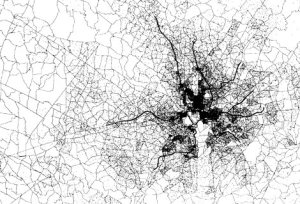
Origin of commuting trips to downtown Washington (federal jobs only, but the private-sector map looks the same).
The vast majority of commuters live inside the Beltway, and very few come from beyond Fairfax County. |
|
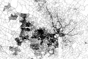
Origin of commuting trips to Tysons Corner.
Thousands come from Reston, Herndon and points west. |
Think those downtown workers are the ones clogging I-66 and I-95? Not likely. The situation could not be more clear: If you want to foster Smart Growth and multi-modalism, put your jobs in the city. If you want to foster sprawl and congestion, put them far away. End of story.
PS: GGW has more maps for other job centers. The map for commuters to Ornjington (yeah, I’m sticking with it) is somewhere in-between, while the map for Reston/Herndon trends even more to the far-away western suburbs than does the Tysons map.
July 7th, 2009 | Permalink
Tags: featured post, urbandesign
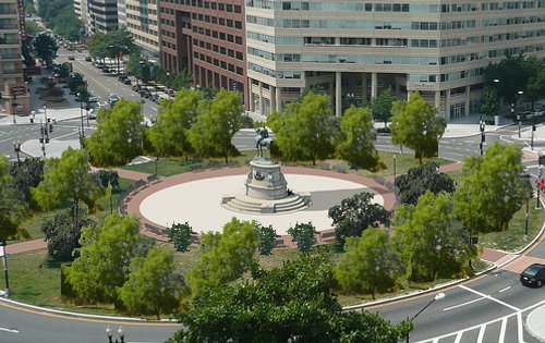
Orangington: A proposalPronunciation confusion: Pronounce it with only three syllables, so orn-jing-ton rather than the orangutan-like four syllable or-anj-ing-ton.
By now most readers have probably already seen Arlington: The Rap, the hilarious spoof that lovingly pokes fun at Washington’s even-more yuppie-filled western extension. The rap isn’t really about Arlington, though; it’s about that specific portion of Arlington lying along Metro’s Orange line that over the past generation has morphed from sleepy suburb to central city destination. The rap got me thinking: That part of Arlington needs a unique name. People talk about it all the time. Why not give it a single identifier?
“Arlington”, after all, refers to the whole 26 square mile county, from Chain Bridge on the north to Four Mile Run on the south, and west almost to Leesburg Pike. “North Arlington” also won’t do, since it refers as much to the rolling suburbs north of Route 29 as it does to the Orange Line Corridor. “Orange Line Corridor” itself is too much of a mouthful, as are the other frequent substitutes, “Wilson Boulevard Corridor” and “Rosslyn-Ballston Corridor”. Even shortening to “R-B” or “R-B Corridor” leaves much to be desired.
But how about “Orangington”? It spells a little awkward, but it sounds verbally clean, fits the blankington scheme used by Washington, Arlington and Shirlington, and the connection between the neighborhoods in question and Metro’s Orange Line is so strong that it’s immediately obvious what the name refers to. Normally I’d be hesitant to try and force a contrived name on unwanting locals (Penn Quarter and NoMa, anyone?), but in this case there does seem to be a need and the name does seem to be pretty organic. Indeed, I’ve been dropping it in casual conversation lately and although I get some “I’ve never heard that” comments, everyone I’ve spoken to has understood the reference immediately. It seems a natural moniker for an area that increasingly needs one.
So how about it, folks? Orangington from now on?
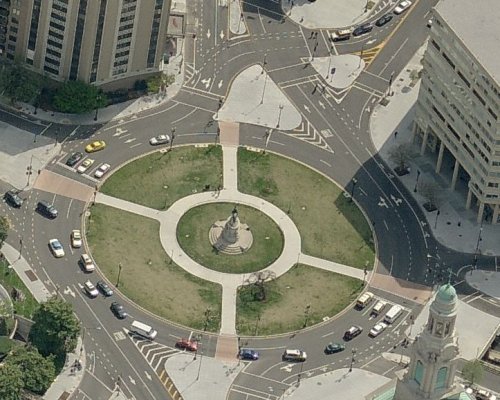
View Orangington in a larger map
Approximate boundaries of Orangington (in orange).
Cross-posted to Greater Greater Washington.
June 22nd, 2009 | Permalink
Tags: featured post, in general
Is downtown architecture losing ground?
While attending yesterday’s Urbanexus lecture by Harriet Tregoning, I listened to an exchange between Tregoning and an audience member about “design excellence” in Washington’s downtown architecture. The audience member questioned why downtown architecture isn’t better. The implication in the discussion was that Washington is a stodgy, conservative city that would be oh so much better if only it embraced contemporary here and now architecture, and if only our height limit weren’t around to constrain creativity.
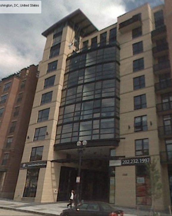
But if Washington has an architecturally stodgy downtown, is it really the fault of the architectural conservatives? When I compare office buildings constructed over the last couple of decades, it seems to me we did a lot better in the 1990s, under influences that would be considered more conservative, than we’re doing now. In the 90s it didn’t matter that we had a height limit, architects found ways to make buildings interesting using crowns, distinct corners, spires, and a whole host of other traditional tricks that relied on details and ornament. If the buildings they produced weren’t exactly going to be major international landmarks, they were at least interesting and generally attractive.
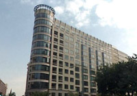
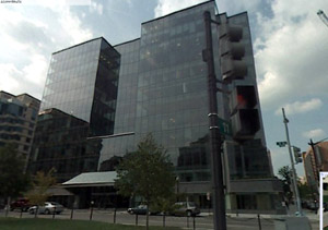
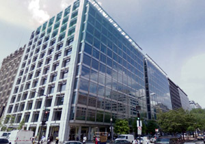
But since the 90s, the world of so-called “cutting edge” architecture has more or less abandoned such ornament and adopted a more retro Meisian modernist aesthetic, resulting in the re-emergence of blank glass boxes as the high end of design. Instead of buildings like the two at top right, lately we’ve been getting more buildings like the two at bottom. Seems worse to me, not better.
Of course there are exceptions; not all the 90s buildings were as interesting as those pictured, nor are all the contemporary ones as plain (or “sleek” in the parlance of their supporters), but the question remains: How can we trust an architectural establishment to produce excellent contemporary buildings when “more contemporary” seems to be code for “more boxy”? If downtown’s architecture is stodgy, why in the world should we put our trust for recovery in with designers who want more glass curtain walls? If “faux classical” is such an awful thing, why is “faux Meisian” OK?
I’m all for a more interesting downtown, but don’t trust the modernist crowd to get us there. Not one bit.
May 21st, 2009 | Permalink
Tags: architecture, featured post
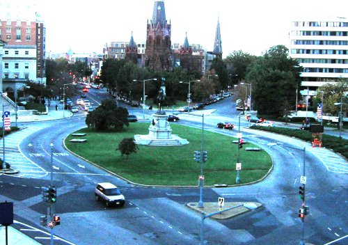
Thomas Circle the way it should beDC Metrocentric has an interesting post up in regards to Thomas Circle. They say:
“In 2006, DDOT carried out a $6 million renovation (of Thomas Circle). New lighting, crosswalks, bike lanes, and sidewalk were added. These days the Circle is looking pretty good, but is still missing one thing– life… The thing is, a few small additions could be made to make Thomas Circle a neighborhood destination in its own right. Benches would be a good start, giving pedestrians a place to sit and people watch from. New trees could provide shade on hot days. Removing the fence in the middle might also be a good idea, as it would allow pedestrians to utilize the statue steps as additional seating. While we’re at it, we might consider paving over the circular patch of grass at the center of the circle, which currently serves no purpose. This would create a larger pedestrian plaza area like in Dupont and Logan Circles.”
Additionally, commenters in the Metrocentric thread suggested adding food vendors and planting some border shrubbery around the edges of the park.
I agree with all those suggestions. In fact, I’ve had most of the same thoughts myself, as probably has just about anyone who has walked through the circle since its 2006 renovation. They’re pretty obvious ideas; it doesn’t take much imagination to see what amenities exist at Dupont and Logan that are missing at Thomas, after all. DDOT got a lot of things right in 2006, but they didn’t quite go far enough.
Metrocentric has a good photosimulation showing some of the suggested improvements. I took the sim a little farther with the third image below. Looks like a pretty nice lunch spot.
Thomas Circle before 2006. Photo from coryindc.
Thomas Circle now. Photo from Live Maps.
Thomas Circle as it could be. Photo manipulation by Chris Loos for DC Metrocentric, with some modifications by BeyondDC.
April 29th, 2009 | Permalink
Tags: featured post, urbandesign
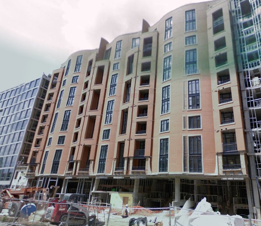
Are architectural hybrids any good?For years the world of architecture has been split between two opposing camps, one camp favoring traditional buildings and the other favoring modernist ones. While traditionalists prefer ornamented buildings with human-scale details, facade diversity, and proportionate bases and caps, the modernist crowd favors more sculptural buildings and claims that we should look forward rather than back, build “of our time”, and that the historicism favored by traditionalists is inappropriate in a 21st Century world. This battle between supporters of traditionalism and modernism has provoked fronts all across the blogosphere, from Jim Kunstler’s famous Eyesore of the Month to repeated threads on BeyondDC and Greater Greater Washington.
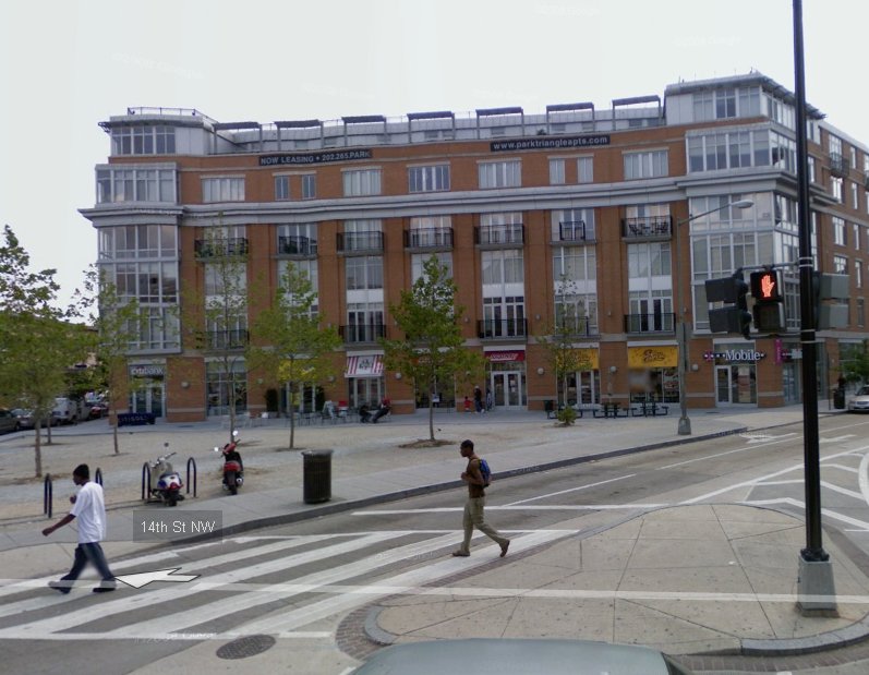
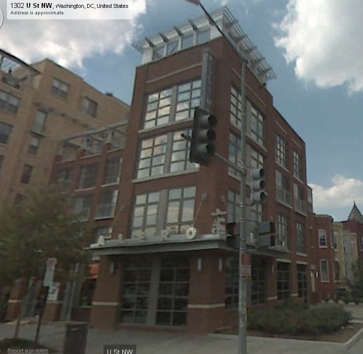
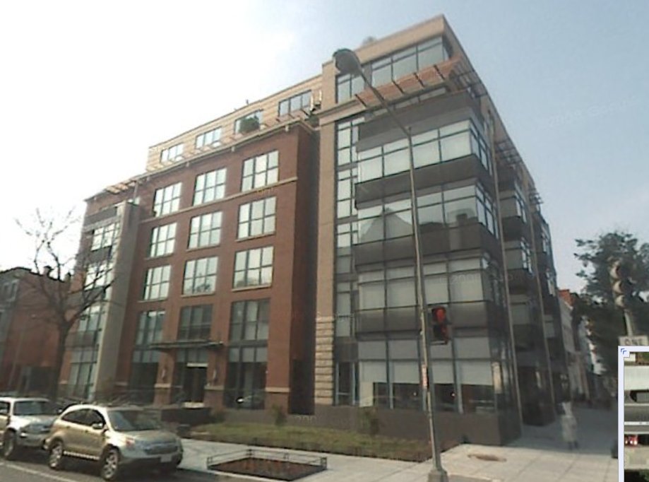
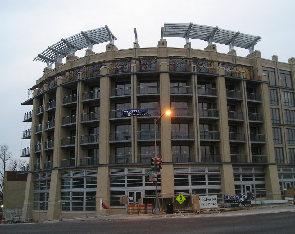
But I wonder, do the two positions have to conflict? The recent condo boom produced some interesting buildings that used clearly contemporary materials and styles, but followed essentially traditional principles. I’m curious what people think of such buildings. Pictured below are six buildings from the recent boom. All have facade detailing (if not exactly beaux arts level ornament) and a base-middle-top layout, but none of them are straight revivals of old styles; except for including brick as a material (often in a decidedly contemporary color), none of them appears historicist. These hybrid buildings are both “of our time” and traditionally-inspired.
What do people think of them? Thumbs up or thumbs down? Is this a middle ground we can all support, or a worst-case concession that satisfies nobody? Putting aside any lingering feelings about gentrification or the housing bubble and focusing just on the architecture, are these good buildings?
Click each picture to enlarge. Unless otherwise noted all photos come from Google Street View.
Cross-posted at Greater Greater Washington.
April 10th, 2009 | Permalink
Tags: architecture, featured post
Will the new S9 be faster than Metrorail?Next week the 16th Street bus line will become the latest to get the MetroExtra treatment. I’m not sure if any of the buses will actually use the MetroExtra paint scheme, but the service will be reworked to provide both local and express buses. The schedule and map for the express S9 route are available here (H/T Dr. Gridlock).
Will this be a faster way to get from McPherson to Columbia Heights? I picked a random start time (4:00 pm) and plugged it into WMATA’s trip planner to compare the travel time of Metrorail to S9 bus. Trip planner says it takes 26 minutes to make the trip via Metro (with a 9 minute layover at L’Enfant), while the S9’s schedule says it will take only 15 on the new express bus. 26-9=17, so even discounting wait time and going strictly by travel time, the bus should be faster. Of course you have to wait for the bus too, but the S9 will have Metro-like 10 minute headways, so wait time should be about a wash.
The S9 will have limited hours, but it seems that if you’re moving between Mid-City and downtown during those hours it could very well be a faster option than the train. I’ll definitely be trying it out.
PS: Don’t take this post as an endorsement of BRT as superior to rail in an overall sense. I’m talking speed here, but there are numerous other ways Metro is vastly superior to any bus. At the very, very least it is worth mentioning that the S9 will have a harder time sticking to its schedule, since it will be operating in mixed-traffic. Being better than a typical bus isn’t the same as being better than rail.
March 26th, 2009 | Permalink
Tags: featured post, transportation
Safety in numbers, not in armor
|
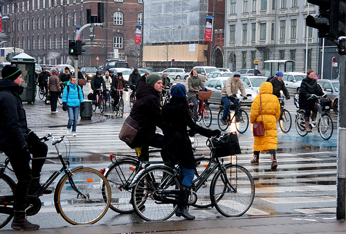
Cyclists in Copenhagen are safe even without helmets, thanks to all the other cyclists around them. Photo courtesy Copenhagen Cycle Chic |
CityPaper recently published an article sensationalizing the topic of bike helmets. Anybody who doesn’t wear one, claims CityPaper, is a fool.
That just isn’t the case. While it’s true that mountain bikers and racers should always wear helmets, the situation is quite a bit more complicated for urban cyclists riding on mixed streets for transportation.
1) A helmet won’t save you from the big danger of urban cycling – getting hit by a larger vehicle.
2) The very safest thing for cyclists in the city is for there to be lots of other cyclists in the city around them, and if everybody thinks they need special equipment any time they want to ride a bike, that reduces the number of cyclists on the street.
When it comes to biking, there is big time safety in numbers. Drivers who see a lot of cyclists around know they have to share the road and drive carefully. On the other hand, if there are few cyclists, then drivers don’t expect them to be there, don’t watch for them, and drive in a manner that increases the danger to cyclists. After all, if you’re not looking out for something, how can you avoid it? Studies have shown that adult helmet laws dramatically reduce cycling use. If there’s safety in numbers, that’s counter-productive; helmet laws actually make cycling more dangerous, rather than safer.
So as a cyclist, the safest things you can do are to bike more and encourage other people to bike more. Not owning a helmet, or not having one handy all the time, shouldn’t dissuade anyone from riding because every time there is one less cyclist on the road that makes the road more dangerous. Of course wearing a helmet doesn’t hurt and is generally a good idea, but don’t let the absense of a helmet ever prevent you going somewhere by bike.
The Examiner has more.
March 20th, 2009 | Permalink
Tags: featured post, transportation
|
Media


Site
About BeyondDC
Archive 2003-06
Contact
Category Tags:
Partners
|


