|
Special Features


Image Libraries


|
|
Blog
Adventure! Romance! Highway rest stops?Am I crazy to actually like big highway rest stops?
Maryland’s newest one is scheduled to open along I-95 next week, following a complete reconstruction. And somehow, despite the fact that it’s merely a collection of fast food, dirty restrooms, and convenience marts, I think there will be just a touch of romance to the place.

The newly rebuilt Maryland House rest stop. Photo by MDTA.
Something about all waystations appeals to me. I know they’re mundane and often uncomfortable places, but all of them, from airports to train depots to I-95 travel plazas, somehow tickle my sense of fantasy.
I think it’s because waystations are the gathering places of travel, where humanity comes together and rests before setting off on adventure. Rest stops may not be exotic themselves, but they’re where exotic stories begin. Somehow, with hundreds of traveling partners bustling around me, being in a waystation makes travel feel like a quest.
Or maybe I’ve just got an overactive imagination. Does anyone else feel this way?
 Cross-posted at Greater Greater Washington. Cross-posted at Greater Greater Washington.
January 16th, 2014 | Permalink
Tags: in general, question, roads/cars, transportation

Want the urban lifestyle? DC’s best corner is…Imagine a generic urbanist. Someone who loves walkable, transit-friendly, mixed-use cities. Without knowing where this hypothetical person works, where their friends live, or how much money they might have, what single DC street corner would be the most ideal place for him or her to live?
Put simply, what’s DC’s most livable urban address?
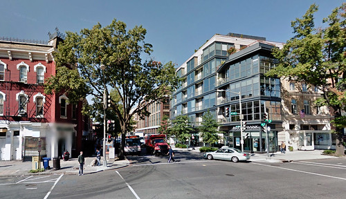
14th and P is the epicenter of everything. Image from Google.
The answer is 14th and P, NW.
There are thousands of great places to live all over the DC region, but to find the singular best corner, one has to apply some pretty strict criteria.
The ideal corner will be within easy walking distance of all 5 Metrorail lines. It will be on a major commercial main street, within one block of a supermarket. It will have bikeshare access, and it will be near a wide variety of shopping and dining amenities. There will be a park nearby, but it need not be quite as close as the supermarket.
The Metrorail requirement eliminates everything but Downtown and the southern end of Dupont & Logan. The Capitol Hills and Columbia Heights of the world are wonderful, but comparatively less well-connected.
The major grocers in that area include the Safeway at 5th and L, the new Giant at O Street Market, the Safeway at 17th and Corcoran, and the Whole Foods at 14th and P.
5th Street and O Street have fewer other amenities nearby. Chinatown is close, but not right there. They’re less desirable than the other two.
Corcoran Street has all the amenities, but it’s on the very outer edge of walkable from the Orange & Blue Lines.
That leaves P Street. It’s at the middle of all 5 Metro lines, on 3 major bus routes, has a bikeshare station, and is within a block of the best cycletrack in the city. It has a grocery store, a CVS, a hardware store, and tons of restaurants right there. Logan Circle park is a block away. All the riches of the 14th Street corridor are in easy reach. It’s perfect.
And that’s why 14th and P is the city’s most livable urban corner. Others are nice, others may be better for you given your circumstances, but 14th and P is the prime address.
But what do you think?
Cross-posted at Greater Greater Washington.
December 12th, 2013 | Permalink
Tags: land use, question
Where is DC’s train to the beach?
|
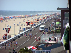
Ocean City’s boardwalk, with its tram. |
If you live in New York, Philadelphia, or Boston, you can hop onto a commuter rail train any summer weekend and travel to the beach. But not if you live in DC. Here we have no train, and the buses are impractical and expensive.
Let’s compare:
Boston’s Massachusetts Bay Transit Authority recently launched its Cape Flyer service, from Boston South Station to Cape Cod. A round trip ticket to Hyannis is $35.
New Jersey Transit runs trains from Philadelphia 30th Street Station to Atlantic City for $20 round trip, and from New York Penn Station to the Jersey Shore for $25 round trip. New Yorkers can also take Long Island Rail Road from Penn Station to Montauk for about $40 round trip.
For DC, there is no train, much less an affordable one. There are no tracks directly between DC and Maryland’s Eastern Shore. The only track connection is at the very top of Chesapeake Bay, near Wilmington, DE. Amtrak does offer service to Ocean City, but you have to connect to an Amtrak bus at BWI, and it’s $120 for a round trip.
Greyhound also runs buses from DC to Ocean City, but it’s $50-$100 per round trip, depending on how far in advance you buy tickets online.
Building a new rail bridge across Chesapeake Bay is probably not practical. Even if it were, that’s surely not the top priority for limited transit funding. But why not better bus service? Ocean City is a natural transit destination; it’s compact and urban, at least near the boardwalk.
As summer rolls by and Washingtonians head out for weekend jaunts to the beach, how many of us wish we didn’t have to rent a car to get there?
July 8th, 2013 | Permalink
Tags: bus, commuterrail, intercity, proposal, question, transportation
Height limit questions, answers, and more questions
|
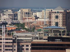
Arlington’s Orange Line corridor. Home to tall buildings, and good for the region. |
The question over whether or not to raise DC’s height limit has come up periodically for several years, but gained new traction earlier this month when some members of Congress asked for a study about modifying the height limit legislation. With the possibility of actual change looming, more and more people are weighing in.
Most height limit opponents have so far based their position on the argument that taller buildings downtown would be more economically efficient, and that allowing some offices to be located outside downtown is costing DC a lot of money.
The latest to do so is David Schleicher at The Atlantic Cities, who opposes the height limit and poses a series of questions to supporters.
Having long advocated for raising the limit strategically, both downtown and in surrounding areas, I cannot be characterized as a height limit supporter. But I also think that the economic arguments put forth by the loudest height limit opponents, including Schleicher, are too narrow and miss important considerations.
> Continue reading
November 28th, 2012 | Permalink
Tags: question, urbandesign
Map of Metrobus routes with articulated buses (draft)Articulated buses have been getting a lot of attention lately. WMATA has expanded their use, and prior to selecting a streetcar Arlington considered using them on Columbia Pike. But where do the long buses actually run?
Curious to answer that question, I set out to identify the routes where I’ve seen articulated buses. This map shows the effort so far, but it’s probably incomplete. I don’t have any actual data on this, only what I’ve noticed anecdotally, and what a few other people have told me.
Take a look, and use the comments to let me know what I’ve missed or gotten wrong.
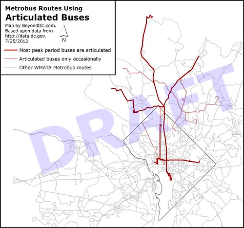
List of routes shown as “most articulated”:
- 70 – Georgia Ave in DC
- Y series – Georgia Ave in MD
- S1 – 16th St
- X2 – H St
- J2 – East West Hwy / Old Georgetown Rd
- Z series – Colesville Rd (shown truncated on the map)
Routes shown as “occasionally articulated”:
- L2 – Connecticut Ave
- S2 – 16th St (S4 also shown on map, will be removed with next draft)
- C2 and C4 – University Blvd
- K6 – New Hampshire Ave
July 25th, 2012 | Permalink
Tags: bus, question, transportation
Q&A: Why most cities build light rail instead of metro
|
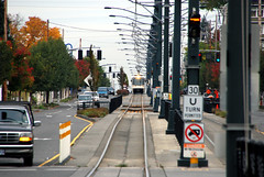
A: Light rail doesn’t need as much separation as metrorail, and can fit in narrower spaces. |
Question: Why do most cities that are building new rapid transit systems use light rail, instead of heavy metrorail?
Someone asked me that question over the weekend. Here is my answer:
It basically comes down to cost and flexibility. Light rail is cheaper and more flexible, so cities use it unless they absolutely need the higher capacity of metrorail.
Heavy metrorail is built to be 100% grade separated all the time. That means nothing ever crosses the tracks. If you want to cross the tracks (as a pedestrian or in a car), you need a bridge or tunnel on a different level so that you can do it while trains are using the tracks simultaneously. This makes metrorail very expensive, and limits where you can put rail lines. In very highly urbanized areas such as downtowns, your only options are basically in a subway or elevated above ground.
Light rail on the other hand works at-grade, which is to say you can allow streets, sidewalks, and pedestrians to cross the tracks. That makes it much cheaper, and much easier to locate/build. You can run light rail along any street you want, basically. This is especially beneficial in downtown areas, where instead of a massively expensive subway or el, you can simply run light rail on the surface. You might opt to give it a dedicated lane or you might opt to run it in a lane mixed with cars, but either way it’s easier and cheaper than a subway/el.
And of course, light rail can run fully grade-separated in a subway or an el if you want it to, it just isn’t required. So if you find that you need a metrorail-level of capacity for part of your line, but not for all of it, you can still use light rail. Metrorail doesn’t offer that kind of flexibility. It has to be grade-separated all the time.
So light rail is generally slower and has lower capacity, but is much easier to fit into cities and is much more affordable. So you would only go to the expense/trouble of building metrorail when you need that very highest level of capacity.
Think of metrorail as being like the transit equivalent of an interstate highway, where there are no traffic lights and there’s not supposed to be anything that impedes traffic. On the other hand, think of light rail as being more like the transit equivalent of a big arterial road, or like Fairfax County Parkway.
July 16th, 2012 | Permalink
Tags: lightrail, metrorail, question, transportation, urbandesign
What’s the real Ward 9, and other thoughts on demographics
Census results say the District is rapidly losing its black majority, which has Marion Barry rather upset. He says:
“We’re going to stop this trend — gentrification… I believe in integration, but I don’t believe in the apartheid we have in Ward 8.”
Barry went on to refer to Prince George’s County as “Ward 9″ because so many of the District’s former residents have moved there in recent years.
As a white person I feel stuck between a rock and a hard place when it comes to gentrification, because it seems like no matter what I do, I’m the bad guy. First white people were bad guys for abandoning the city, now white people are bad guys for coming back, except in Ward 8 where white people are bad guys for not coming back. ‘We’ve got to stop gentrification, but we’ve got to do something about the lack of integration in Ward 8′. Uhhhh…
Anyway, I thought Barry’s Ward 9 comment was interesting, but also potentially applicable to more places than just Prince George’s County. Arlington is an obvious contender, since it’s dense and urban and, y’know, it used to be part of DC. Maybe arguments could also be made for Silver Spring, or Baltimore, or – who knows – Denver.
So I put together the little survey attached. What do you think?
March 25th, 2011 | Permalink
Tags: question, social
Why cycle on 16th Street?
Every morning rush hour while waiting for the 16th Street bus I watch a steady stream of cyclists fight through the motor traffic to bike south towards downtown.
One block to the west, 17th Street is one-way going south and is much lighter with cars. One block to the east, 15th Street has the city’s best on-street bike facility, the south-bound cycle track. Both are excellent streets on which to cycle, while 16th Street is a high-speed and dangerous maze of cars, buses and trucks.
Why in the world would anybody want to bike on 16th when such excellent alternatives are so easily accessible? While it’s true that neither 15th nor 17th go as far north as 16th, surely the ease of cycling on either of those streets makes it worth the trouble of cutting over a block once possible, doesn’t it?
I don’t begrudge any cyclist their fair place on the street, but as someone who treats his bike as a tool for transport, I always prefer the easiest route possible. When I bike to work instead of ride the bus, which I do occasionally, I use 17th.
So help me out here. I’m befuddled. Why would any cyclist choose to ride south on 16th Street at the height of morning rush hour?
Update: According to comments here and via twitter, 16th Street is much faster. If you’re comfortable with the mixed traffic, you get there quicker via 16th.
August 5th, 2010 | Permalink
Tags: bike, question, transportation
|
Media


Site
About BeyondDC
Archive 2003-06
Contact
Category Tags:
Partners
|


