|
Special Features


Image Libraries


|
|
Blog
Get a look at 23rd century public transit in the latest Star Trek movieIn the Star Trek universe, transporter technology can instantaneously whiz characters from starships to planets and back again. The latest Trek movie, Star Trek Beyond, shows us transporters in service as public transit.

Public transporter booth. Screencap from Star Trek Beyond. Click for video.
Although transit has never been a key element of Star Trek, which is rarely set in big cities, the franchise’s long history does include a few scenes with futuristic transportation.
A few seconds later in that same scene, a high-speed train zips by.
In the previous movie, 2013’s Star Trek Into Darkness, we saw a brief glimpse of a futuristic articulated bus.
And finally, in a 1995 TV episode of Star Trek Voyager, one character emerged from a 24th Century San Francisco subway system called Trans Francisco.
But all those futuristic trains aside, the transporter has got to be the coolest of Trek’s multimodal options.
 Comment on this at the version cross-posted to Greater Greater Washington. Comment on this at the version cross-posted to Greater Greater Washington.
November 7th, 2016 | Permalink
Tags: fun, transportation

Why is this MARC train parked in Denver?If you were in Denver this weekend, you might’ve seen an unusual sight: A MARC commuter rail train parked behind Denver Union Station.

MARC in Denver. Photo by Ryan Dravitz.
What gives?
Turns out the train was in Colorado as part of the testing for MARC’s new locomotives. Officials wanted to test the new locomotives with actual MARC rolling stock, to evaluate how the locomotives performed in real-life conditions.
The Federal Railroad Administration has a test track in Pueblo, CO, so off this train went.
The train was in Denver because Amtrak carries the equipment on a regularly scheduled train from Denver to Chicago (#5, the California Zephyr) and then from Chicago to DC (#29, the Capitol Limited).
Thanks to Matt Johnson and Twitter user @kencon06 for helping to solve this mystery.
Comment on this at the version cross-posted to Greater Greater Washington.
October 5th, 2016 | Permalink
Tags: commuterrail, transportation
Why we don’t have world class BRT in the US, explained with one pictureBus rapid transit lines in the United States badly lag the world’s most high-quality systems. This photo from Buenos Aires shows why: No US city is willing to dedicate so much street space to buses.

Buenos Aires BRT. Photo by exploreadorurbano on Instagram.
Count the lanes dedicated to the busway in that picture. Including the stations, medians, and bus lanes, it totals about eight lanes worth of traffic.
It takes that kind of dedication to fulfill BRT’s promise of subway-like service and capacity. You need all the components: Multiple bus lanes including passing lanes, big stations physically separated from the sidewalk, unmistakable barriers between the busway and general traffic.
Can you imagine any US city dedicating eight lanes to buses on a single street? On most streets we couldn’t do it even if we wanted to. K Street is 10 lanes wide including its medians, but Georgia Avenue and H Street are generally only six. 16th Street is five lanes at the max. Even if we completely banned cars from those streets, we’d lack the width to build Buenos Aires-style BRT.
Admittedly, Buenos Aires is an extreme example. This photo is from Avenida 9 de Julio, possibly the world’s widest city street. Planners there had an incredible amount of space to work with. Bogota’s famous TransMilenio BRT is probably a more instructive example; it takes more than five lanes.
Five lanes is physically possible on many US city streets, including in DC. But physically possible and politically practical are vastly different standards.
We wouldn’t want to anyway
Even if cities in the United States had both the physical space and political will to dedicate five-to-eight lanes to buses, there would be big trade-offs in doing so.
Streets that are too wide or have too-fast-moving traffic are hard for pedestrians to cross, and thus create barriers that can destroy a city’s walkability.
Bogota’s awesome five lane busways are practically highways, accounting for the several lanes of car traffic on either side. And like highways, they’re very good at moving vehicles and very hostile to pedestrians.
About the only way to make such a wide busway work on a city street without creating a highway would be to dedicate the entire street to transit, and not have car lanes on either side at all. Some US cities do have transit-only streets, so that may well be possible. But it would be different than South America’s model.

Arlington’s narrower Crystal City busway.
Smaller busways make sense for the US
None of this is to say that BRT in the United States is hopeless. It’s absolutely possible to build a solid and useful BRT line without quite that much street width. They just won’t be comparable to a subway in speed or capacity without passing lanes and gargantuan stations.
But who says they need to be?
Narrower busways like in Arlington and Ontario still offer tremendous advantages over running buses in mixed traffic. They speed up buses a lot, and are vastly more practical when retrofitting existing streets.
And while it’s true that North American-style busways can never have such high capacity as South American ones, well, that’s what rail is for.
It would be silly to insist one mode, any mode, must on its own accomplish all a city’s needs. Smart planning matches the need to the corridor, and is flexible enough to use the right mode, and the right street design, on every corridor, given the specific issues of that location.
Comment on this at the version cross-posted to Greater Greater Washington.
October 3rd, 2016 | Permalink
Tags: BRT, transportation, urbandesign
Public reaction to Metro’s proposed cuts proves the need to be vastly more transparent about rebuildingMetro has a trust problem that’s impeding the agency’s ability to fix its decaying rail system. Riders and city officials don’t believe the agency’s proposed permanent cuts are necessary. To solve this one way or another, Metro must regain rider trust by precisely reporting exactly what its rebuilding needs are, and whether efforts thus far have been successful.
This series of seven tweets explains why this problem persists, and how being legitimately transparent can only help WMATA achieve its goals.
WMATA has tried to explain its maintenance plans, and has occasionally reported on progress, but there’s no single resource available to riders all the time that compiles all Metro’s needs, both SafeTrack and non-SafeTrack, and reports on progress in detail.
For example, how many feet of track must be rebuilt before Metro reaches a state of good repair? Out of that, how many feet has WMATA successfully rebuilt to date? How many feet were fixed in July?
That’s the kind of information that will help decision makers and the public understand what WMATA needs, and thus support informed decision-making.
If possible, still more detail would be even better. How many rail ties have been fixed, out of how many that need to be? How many insulators? How many escalators and elevators? That level of detail may not always be possible to report (WMATA may not know the full needs until they start doing work), but after so many years of frustration, this is the kind of information the public requires to feel comfortable with Metro’s progress. The data should be specific and be listed for each station or between stations, if possible, so passengers can know exactly where work still needs to be done
In Chicago, ‘L’ riders can see a detailed map of slow zones in the system, and New York’s MTA runs video explainers about system problems. These are good examples worth emulating, but WMATA must go further.
If Metro officials hope to get buy-in for extreme measures like permanently cutting late night service, it’s reasonable for the public to demand extreme explanations, and reassurance that sacrifice will result in improvements. Without more frequent and more candid communication about progress, trust in WMATA will continue to erode, political support for sacrifices will be hard to obtain, and the spiral of decaying service will likely deepen.
Comment on this at the version cross-posted to Greater Greater Washington.
September 18th, 2016 | Permalink
Tags: government, metrorail, proposal, transportation
VRE’s map keeps getting more diagrammaticLast year, when Virginia’s VRE commuter rail system opened a new extension to Spotyslvania, the agency completely redesigned its map. The new version follows a trend for VRE: Every iteration gets more and more like a subway diagram, and less like a true geographic map.

VRE’s system map over time. Original images by VRE, compilation by the author.
The new map is at least the third completely different version VRE has tried since its launch in the 1990s. The original map was purely geographic, and oh-so ’90s. The second map was a hybrid with simplified geography. The newest is a pure diagram, with equally-spaced station symbols and only the barest nods to geographic context.
It generally makes a lot of sense for transit agencies, and particularly rail providers, to use diagrams instead of geographic maps. Features like the Potomac River’s many inlets, or minor curves on the rail lines, aren’t information that riders need to know, but they clutter the original map, making it hard to discern the information that does matter. On the other hand, it’s useful to know that the Fredericksburg line roughly parallels I-95 and that the Manassas line roughly parallels I-66.
Cameron Booth, the internet’s foremost expert on transit maps and author of TransitMap.net, reviewed VRE’s new map in December, calling it a “solid” but “unremarkable” effort.
Across the river in Maryland, the MARC commuter rail map remains completely geographic.
Comment on this at the version cross-posted to Greater Greater Washington.
August 26th, 2016 | Permalink
Tags: commuterrail, maps, transportation
College Park recreated Paris’s “bus stop of the future” on the cheapFour years ago, Paris made headlines for its bus stop of the future, a bigger and better bus stop with amenities like bikesharing and a book-sharing library attached. Now College Park has a bus stop with some of the same amenities, but using inexpensive, off-the-shelf pieces.

College Park’s bus stop of the future.
Paris’ bus stop of the future
In 2012, Paris’s transit agency tried out a luxurious new bus stop design. In addition to the normal sign, bench, and shelter, the stop had electric bikes, bookshelves, wifi, and stylish architecture. It looked great and it made waiting for the bus more enjoyable, but it was expensive and took up a lot of space.
Paris’s concept was a neat idea, but wasn’t ultimately practical for mass production.
 Paris’s bus stop of the future. Image from RATP. But some of the ideas from Paris’s attempt make sense. Locating a bikeshare station next to a bus stop makes it convenient for more people to use both. And book-sharing can be a nice amenity, if it’s easy and inexpensive to manage.
College Park’s version
Enter College Park, where rather than design a custom building, the city simply added some of those components to an existing bus stop using their standard off-the-shelf pieces.
They started with a normal bus stop sign and shelter, then added a standard mBike bikeshare station. To help with maintenance, the city chained a bike tire pump to the station sign.
For the library, they staked to the ground a Little Free Library, a pre-fab wood box for people to take and give away free books. There’s no librarian and no library cards; it runs on the honor system, and relies on people donating as many books as they take.

A similar Little Free Library in California. Photo by Michael R Perry on Flickr.
The stop is at the corner of Rhode Island Avenue and Muskogee Street, in front of the Hollywood shopping center, just one block south of College Park’s first protected bikeway. The stop serves Metrobus lines 81 and 83, which are among the busier lines in Prince George’s County.
It’s no grand Parisian bus station, but that would be overkill. For a bus stop in a relatively low-density suburban area, it’s pretty darn nice.
Comment on this at the version cross-posted to Greater Greater Washington.
August 18th, 2016 | Permalink
Tags: BRT, bus, transportation, urbandesign
College Park has a protected bikewaySay hello to the Rhode Island Avenue protected bikeway. It’s only 250 feet long and it only covers 1/3 of a block, but it exists.

College Park’s short protected bikeway. Photo by Matt’ Johnson.
The protected lane is part of the larger College Park Trolley Trail. For most of its length the Trolley Trail runs either off-street or as normal on-street bike lanes. But for this short segment in front of Hollywood Shopping Center, a concrete barrier makes it a legit, if short, protected bikeway.
As far as I know, it’s the first protected bikeway in Prince George’s County.
Welcome to the club, Prince George’s!
Comment on this at the version cross-posted to Greater Greater Washington.
August 4th, 2016 | Permalink
Tags: bike, transportation
Using tape, paper, and potted plants, Arlington built a temporary bikewayOn June 11, Arlington closed a block of bustling Wilson Boulevard for what organizers called the Active Streets Festival. There were bike-oriented games and activities, plus a collection of temporary bikeways “built” with tape, paper, and potted plants.

Pop-up protected bikeway. Photo by BikeArlington.
The festival took place during the Air Force Association cycling race, when many Arlington streets were closed anyway. The Active Streets Festival gave Arlingtonians who weren’t racing something bike-related to take part in.
Planners “built” a series of temporary bike lanes, all on the block of Wilson Boulevard between Washington Boulevard and 10th Street North.
On one section, a row of potted plants formed the barrier for a protected bike lane. On another, a row of parked cars did the same. Elsewhere, washable homemade green “paint” and a thick roll of tape formed a green bike lane, a buffered bike lane, and sharrows.

Pop-up green lane and buffered bike lane. Photo by BikeArlington.
By using easy-to-set-up and easy-to-take-down temporary materials, Arlington planners tangibly showed residents what Wilson Boulevard might look like if its street space were allocated differently. There’s no proposal to change Wilson permanently, but the example can be instructive for future projects on other streets.

A BikeArlington worker lays down strips of tape to create the buffered bike lane. Photo by BikeArlington.
Tangible benefits aside, the whole thing was a heck of a lot of fun.

Wilson Boulevard with its pop-up bike lanes in place. Photo by BikeArlington.
Comment on this at the version cross-posted to Greater Greater Washington.
June 23rd, 2016 | Permalink
Tags: bike, events, transportation
❤ Georgia Avenue’s new red-surface bus lanesDC’s first bright red bus lanes now adorn four blocks of Georgia Avenue, near Howard University. DDOT crews added the red surface earlier this month.

Georgia Avenue’s new red carpet for buses.
The bus lanes run along both curbs, from Florida Avenue north to Barry Place. They speed Metrobus’ busy 70-series line through what was the slowest section of Georgia Avenue north of downtown.

The bright red color is a strong visual clue to car drivers to stay out of the lane. It’s a stark contrast to the Gallery Place bus lane a dozen blocks south, which is so poorly marked that many car drivers legitimately don’t know it’s there. For these four blocks, drivers will have no excuse.
Anecdotally, the red surface seems to be working pretty well. Most car drivers seem to stay out. To find out for sure, DDOT is in the process of collecting actual data, comparing the car violation rate now to the rate from before the red surface was added.
Nitty gritty
Cyclists and taxicabs are allowed the use the lanes in addition to buses. Signs along the street spell out the exact rules.

Since the lanes are along the curb, cars can enter them to turn right. Dashed white lane markings show where cars can enter.

To avoid wear-and-tear and to make the bus lanes safer for cyclists, the “red paint” is actually a gritty surface coating. If you walk along Georgia Avenue now, you can still see some of the leftover grit along the curb.

❤ the transit red carpet
By adding these lanes and marking them clearly, DC is taking an real step towards prioritizing street space for transit. At only four blocks long they’re are a humble start, but a start nonetheless.
The “red carpet” is an increasingly common part of the street design toolbox in New York, Chicago, San Francisco, and Seattle. It’s great that DC is getting on board too.
With more transit lanes in the works for K Street, H Street, and 16th Street, this humble start will hopefully soon become a trend. A red surface would probably help them all.

Yay!
Comment on this at the version cross-posted to Greater Greater Washington.
June 21st, 2016 | Permalink
Tags: BRT, bus, transportation, urbandesign
Big rundown of lessons & news for DC Streetcar effortsTuesday, May 17 was all-streetcar-all-the-time day on GGWash. We reviewed the H Street streetcar’s operations, and reported on expansion issues both east across the Anacostia and west into downtown.
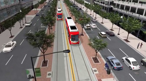
DC Streetcar on K Street Transitway. Image from DDOT.
Here’s a rundown of all the posts:
May 20th, 2016 | Permalink
Tags: streetcar, transportation
|
Media


Site
About BeyondDC
Archive 2003-06
Contact
Category Tags:
Partners
|


