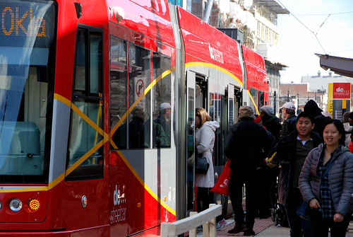
The DC Streetcar is drawing a decent number of riders, so far. Compared to other US light rail and streetcar systems, it ranks near the middle in terms of riders per mile of track. It’s slightly above average, neither horrible nor spectacular.
According to DDOT’s latest streetcar ridership report, the H Street line carried an average of 2,285 passengers each weekday in April. It carries more on Saturdays, but weekday ridership is the standard measuring stick nationwide.
In raw terms, 2,285 riders per day is pretty low. But for a line that only carries passengers for 1.9 miles, it’s actually not bad.
Middle of the light rail pack
Obviously, the 1.9 mile DC Streetcar isn’t going to carry nearly as many passengers as, say, the 90-mile-long Dallas light rail system. And if you rank all US light rail and streetcar systems by total ridership, DC’s 2,285 passengers per day is indeed near the bottom, at 31st out of 37. Dallas is 7th with about 105,000.
But to get a sense of how successful these lines are at attracting riders, we need to compare them on an apples-to-apples basis. To do that, divide the total daily ridership by the number of miles, to get ridership per mile.
And in those terms, DC Streetcar’s 1,203 riders per mile is a respectable 18th out of 37. It’s just barely in the upper half nationally. And it doesn’t even go downtown yet.
Dallas is actually lower at 1,164 riders per mile. Other regional light rail systems that are lower than DC Streetcar include Baltimore (691 riders/mile), Norfolk (784), Sacramento (1,056), Saint Louis (1,035), Pittsburgh (850), and Cleveland (467).
On the other hand, DC is far below the number one system on the list: Boston’s Green line light rail, which carries a whopping 7,126 riders per mile. Other systems near the top include San Francisco’s Muni Metro (4,370 riders/mile), Minneapolis (3,275), New Jersey’s Hudson-Bergen light rail (2,852), and the Portland streetcar (2,723, which is interestingly higher than Portland’s MAX light rail at 2,048).
Compared to H Street’s X2 bus
What about buses?
In terms of raw riders, the X2 bus on H Street is the 3rd busiest bus line in the WMATA system, with 17,400 riders per day as of 2015. The X2 is almost exactly 5 miles long, pegging it at 3,480 riders/mile.
So the streetcar is attracting about one third as many riders as the X2 was before the streetcar started, mile for mile.
But the X2 is a tall order to match. If it were light rail or a streetcar, the X2’s 3,480 riders/mile would make it the third best system in America, after only Boston and San Francisco. That’s one of the reasons a bigger and nicer vehicle makes sense there in the first place.
Plenty of room for improvement, but riders are there
Clearly the streetcar isn’t perfect. Getting it open was a saga, and its lack of dedicated lanes or traffic signal priority continue to hurt. Futurelines absolutely need to be better, and can be better.
And who knows what will happen if DDOT ever starts charging a fare. Atlanta streetcar ridership plummeted when it went from free to $1, but Portland’s streetcar ridership remains high despite adding fares after 11 years of free rides, so that’s hard to predict.
But in terms of attracting riders, DC Streetcar isn’t doing particularly badly.
You can help make sure the next extensions are indeed better by attending upcoming planning meetings, May 17 for the Georgetown extension, and May 19 for Benning Road.
8 lessons about great transit I learned riding the Paris Métro
Paris has one of the world’s great subway systems. Beyond its truly impressive coverage and service quality, here are eight wonderful details about how it operates that US systems would do well to mimic.
Door knobs on a Paris metro train.
1. Door knobs speed trains
In DC and in many US subway systems, when trains pull into stations passengers wait for the train operator to open the doors. That adds a few seconds to every stop while the train idles on the platform, doors shut. Waiting passengers tap their feet and cross their arms.
All those seconds, at every station, every trip, all day, add up. The result is not only less happy riders, but also slower trains that come less frequently and carry fewer people than the system’s theoretical maximum.
In Paris, those delays don’t happen. Each door has a manual knob or button that passengers can push to enter or exit at their own pace. For safety, the doors are all locked while the train is moving quickly. But as it comes to a halt the doors unlock, and passengers can immediately open the doors to exit trains.
Here’s a video, showing how the whole operation makes exiting a train noticeably faster than on WMATA:
WMATA did have automatic doors up until 2008, which were faster than the operator-controlled doors of today. But that was eight years ago, and there’s no indication they’ll be fixed any time soon.
Although the issues for a streetcar are different than a subway, this is one detail DC’s streetcars share.
2. Full platform seating works
Why do WMATA station platforms have so few seats? Especially at side platform stations, why not just line the entire platform with one long bench?
Check out Paris’ Chatelet station, where that’s exactly the layout:
Most Paris stations aren’t like Chatelet. Frankly, with sub-five-minute headways most of the time, a lot of seating isn’t as crucial there as it is in DC. But there’s been many a day I’ve stood for 15 minutes in a WMATA station wishing it had this feature.
3. Flip-up seats add capacity
The first row of seats inside Paris’ train doors flip up. On sparsely-populated trains, riders can sit in the seats comfortably. On especially crowded ones, riders can stand, creating more space on the train.
Yes, riders in Paris sitting on these seats do seem to usually get up and create more space when the train gets crowded. It seems to be part of Paris transit etiquette, like standing on the left on DC escalators. Not everyone does it, but enough do to make a difference.
This arrangement also makes it easier for people in wheelchairs to ride without blocking the aisle.
4. Open gangways really do work
US transit systems are slowly beginning to catch on to the benefits of longer open-gangway trains. If passengers can move from front to back of trains without getting off, that makes trains less crowded and boosts capacity.
All new or recently refurbished lines in Paris have open gangways. And they’re wonderful.
5. Great late night service is possible with only two tracks
Paris’ metro lacks express tracks just like DC’s, and it runs basically comparable hours to WMATA. It’s also decades older than Metrorail. It must have at least similar maintenance needs, and no more time in the day to accomplish them.
Yet somehow Paris manages to run frequent trains late into the night.
A train every 4 minutes at 10:21 pm.
I have no idea how they do it. When do maintenance workers do their work? How do they keep up tracks with trains coming every four minutes?
I wish I knew. If you know, send Mr. Wiedefeld an explanatory note.
And though a bridge over the Seine is a special place, Paris’ els have nice aesthetic touches elsewhere too.
7. Wayfinding can be beautiful
“If you can make something pretty, why not make it pretty?” My wife and I kept coming back to that thought as we explored Paris. These signs, telling riders which direction their metro train is headed are one example of why.
8. Location-specific maps help riders navigate
Going to the airport? Rather than only a tiny icon on the main system map, how about helping riders with a dedicated airport transit map?
In DC we already put location-specific bus maps and neighborhood maps inside every Metro station. Why not unique maps for destinations to which infrequent riders often travel, like airports and stadiums?
What details like these have you noticed on other countries’ transit systems, that you’d like to see imported to the US?
Why widening highways doesn’t work, in one simple gif
Decade after decade, American metropolitan areas continue to widen their highways in order to reduce congestion. And decade after decade, congestion just keeps getting worse. That may be counterintuitive, but it’s because of a phenomenon called induced demand. This simple gif illustrates how it works:
Surely one more lane will finally solve our congestion problem, right? (Slightly better GIFF. Feel free to copy) pic.twitter.com/uDJwqVT3WI
Of course, it’s a little more complicated than this gif. Congestion keeps increasing not only because more people drive, but also because more people drive farther. And because the more highways we build, the less walkable and transit-accessible our cities usually become. And because the more desperate our congestion situation becomes, the more some groups attack using money for anything other than more highway widenings.
Highway congestion is a negative feedback loop. The only way to really solve it, besides economic calamity, is to break out of the loop by attacking its root causes. Rather than applying highway-widening band-aids that only work for a few years, build urban communities with multimodal infrastructure, in which it’s just as convenient (or more so!) for most residents to get around without a car than with one.
That doesn’t mean no new roads are ever needed. New communities and densifying ones need streets, after all. But it does mean we should be skeptical of plans to make highways bigger. In the long term, that money is usually better spent elsewhere.
Metroway runs between Pentagon City and Braddock Road Metro stations. For much of its route, between Crystal City and Potomac Yard, it runs in dedicated bus lanes, making it the Washington region’s first real foray into BRT.
The Alexandria portion of the transitway opened in 2014. Arlington’s portion through Crystal City opened yesterday, Sunday, April 17.
Through Potomac Yard, the transitway runs in a totally exclusive busway—a completely separate road from the regular lanes.
27th & Crystal station.
Stations in the busway have substantial arched roofs and attractive wall panels.
South Glebe station.
Through Crystal City, bus lanes and bus stations hug the curb.
18th & Crystal station.
Since northbound buses run a block away from southbound buses, bus stations are smaller through this section. More like large bus stops.
23rd & Clark station.
Crystal City is pretty quiet on Sundays, so there weren’t many opening day riders and buses only came every 20 minutes. During the week there’ll be a lot more riders, and buses will run every 6-12 minutes depending on the time of day.
Head over to Crystal City and check it out! Or see more pictures of both the Arlington and Alexandria transitway sections via Flickr.
The Purple Line will have America’s longest railcars
According to the latest plans for Maryland’s Purple Line, it will have the longest transit railcars in America. Each train will have a single 136-foot-long five-segment railcar. They’ll practically be open-gangway trains.
A Purple Line railcar compared to Metro and DC Streetcar. Image by the author.
Purple Line trains will be Urbos model trams, built by Spanish company CAF. Urbos trams are modular; you can make them as long or as short as you want. These will be unusually long ones.
At 136 feet long, they’ll be 2 feet longer than the closest US competitor: Austin Metrorail’s 134 foot cars. But Austin’s cars are DMUs, a sort of commuter rail / light rail hybrid, built for longer distance and fewer stops compared to the Purple Line.
The next biggest US light rail cars are Dallas’ 124 foot cars.
Dallas light rail car. 12 feet shorter than the Purple Line’s cars. Photo by Matt’ Johnson on Flickr.
Longer is better
Having one long railcar rather than multiple short ones has a lot of advantages. There’s less wasted space between cars, less expense per rider, and passengers can move back and forth inside the train to find the least crowded spot. Overall, having one long open interior increases the capacity of a train by about 10%, and it costs less.
The downside is you can’t pull individual cars out of service if something goes wrong. It’s all or nothing. But as long as everything works, long railcars are great.
Since the Purple Line will be operated by a private company that faces penalties if it doesn’t meet service requirements, the onus is on them to keep trains in service.
An open interior train on the Paris Metro. Photo by BeyondDC on Flickr.
In transit jargon, these open interior trains are called “open gangway,” and almost everyone else in the world uses them, except the United States. For the Purple Line to move in that direction makes it a national model.
Using these long trains was one of the changes project officials made in response to Maryland Governor Hogan’s demands to reduce the Purple Line’s costs. One long railcar rather than two short ones coupled into a train saves money and keeps train capacity high enough to work.
Hogan’s other changes made the Purple Line a lot worse. They reduced train frequency, eliminated the direct transfer to Metro at Silver Spring, and reduced the electrical power of the line, limiting its capacity. But the move to longer railcars with open interiors may be a silver lining.
April is going to be a huge month for bus lanes. On Monday, April 11, DC will open a four block stretch on Georgia Avenue. Then on Sunday, April 17, Arlington will open the Crystal City transitway.
Crystal City transitway station. Photo by Arlington.
Georgia Avenue
Georgia Avenue’s bus lanes will run just four blocks, from Florida Avenue to Barry Place. They’ll be curbside lanes, with normal bus stops on the sidewalk.
Location of Georgia Avenue bus lanes. Image from DC and Google.
Four blocks is short, but this location is specifically one of the slowest stretches WMATA’s busy 70-series bus line passes through. Bus lanes here will speed the entire line.
Just as importantly, this will be a test project for DDOT to study, and to learn about bus lane implementation. In May, crews will add red paint to the roadway to make the bus lanes more visually obvious. By adding the red surface later, DDOT will gather data on whether the red really does dissuade car drivers from using the lanes illegally.
Red-painted curbside bus lane in New York. Photo by NACTO.
If Georgia Avenue’s four block bus lanes prove successful, they could provide a model for the citywide transit lane network envisioned in moveDC. They could also one day form the backbone of a future Georgia Avenue streetcar.
They’re short, but they’re important.
Crystal City
Get ready for bona fide BRT.
On Sunday the 17th, Arlington will open the second half of the Crystal City Potomac Yard Transitway, better known as Metroway. The first half opened in 2014 in Alexandria, and was the Washington region’s first foray into BRT.
The new Crystal City transitway section will run from Crystal City Metro south to Alexandria, where it will join the existing busway. It’ll be a mix of curbside bus lanes and fully exclusive bi-directional busway.
Crystal City transitway. Image by Arlington.
The DC region once had 60 miles of bus-only lanes. With these projects finally happening, and others like 16th Street on the horizon, it’s exciting to see a reborn network begin to take shape.
Closing Metro lines for months could work, but only if the region provides transit alternatives
WMATA may shut down entire rail lines for months in order to catch up on maintenance more quickly (though, officials noted, no decisions have been made yet). If a shutdown does happen, Metro must thoroughly prepare, communicate, and provide riders who rely on Metro with reasonable alternatives.
Special event bus shuttles. Photo by DDOT DC on Flickr.
A months-long shutdown may make sense
For years, WMATA has been struggling to perform maintenance at nights and on weekends. There’s so much work to do that they can’t complete it all.
A months-long shutdown would theoretically put an end to that, or at least significantly reduce the need for weekend track work. It would let WMATA catch up on all its maintenance needs for a line in one fell swoop. We’d be trading a few months of pain for years of happiness.
WMATA GM Paul Wiedefeld says he is indeed considering the idea. He adds, “In the last few years, we’ve been trying to do this [maintenance] in a sort of piecemeal way, and basically we’ve alienated everyone.”
He’s right. Working at night and on weekends is fine when you’re just doing preventative maintenance. But after years of increasingly terrible weekend service, it’s become clear that model won’t work with WMATA’s need for major rebuilding. With no end to the rebuilding in sight, it’s time to try something new.
This is getting old. Photo by the author.
Closing an entire line end to end may not prove necessary. You can rebuild the Virginia section of a line without closing the Maryland section, for example. And closing the core is much harder than closing outer sections. But closing long segments of a line, say four or five stations long, may well make a lot of sense. On the other hand, if a whole line needs work, maybe shutting it down completely is the way to go.
Whether or not WMATA has the equipment and work crew capacity to do such a big job is an open question. But if so, or if it can expand as needed to do so, it may not be a terrible idea.
Leaving riders without options wouldn’t be acceptable
So yes, it’s very possible that closing major segments of Metro lines for months would be the best way to get this painful decade of rebuilding behind us.
But we absolutely cannot simply shut down Metro and hope for the best. Metrorail is not an optional service for the Washington region. Hundreds of thousands of people rely on it every day, including many who don’t have access to cars. Telecommuting saved us for one day, but can’t work for months on end.
Simply closing Metro without providing alternatives isn’t an option. Too many people wouldn’t be able to reach their jobs. It would be a calamity, economically and for thousands, personally:
@mstharrington@EricFidler if Red ever went down I think I'd have to quit my job. Particularly ironic considering what I do.
If this is really going to happen, WMATA and the affected jurisdictions would have to work together to provide transit alternatives. We’d need special bus shuttles to replace the shuttered Metro line, temporary bus lanes to make longer-distance bus travel fast enough to be practical, greatly expanded transportation demand management, and more. We’d need a comprehensive transportation management plan.
Such a plan might look something like what Matt Johnson suggested in 2013, when WMATA considered closing part of the Red Line for six weeks. That shutdown hasn’t happened, but many of the same ideas would be necessary anywhere.
It wouldn’t be easy, and it would require sacrifice from everyone, including drivers who don’t use Metro. It’s impossible to stop running a transit line that carries a hundred thousand passengers without making life hard. Substitute buses absolutely would not be as good as Metrorail, not for transit riders and not for car drivers who have to share road space.
But the current situation is hard too.
WMATA will need to study this concept in detail. Then they’ll need to share their detailed findings with the public. What are the real options, what are the trade-offs, how much time and money would this save, and what will the Metro system look like when it’s over? If Metro expects the public to buy this idea, they’ll need to be forthright.
But it’s possible. WMATA could do this and it might be successful, if and only if they take the time and money to plan, prepare, and do it correctly.
WMATA’s PlanItMetro blog has released a trove of data on Metro station use. Here’s one snippet: All 91 stations, ranked by the average number of riders who entered the faregates each weekday in February, 2016.
Rockville misses the forest for the trees with its plan for an 18-lane mega main street
Rockville Pike could one day become a 252-foot-wide mega boulevard with 12 car lanes, 4 bike lanes, 2 bus lanes, and over 50 feet of landscaping. But in designing a street with more than ample room for cars, bikes, and buses, planners abandon any hope the street will be walkable.
The plan for Rockville Pike. Image from Rockville.
Everybody gets a lane!
Rockville Pike is one the most important retail strip highways in the Washington region. Like most 20th Century retail roads, it’s designed for cars, and it carries a lot of them.
Rockville wants to make it a more urban main street, so planners there are drawing up a redevelopment plan. It’s a laudable goal, and it’s not easy on a high-traffic state highway like Rockville Pike.
At first glance, this plan has all the components of a good complete street design: Tree-lined sidwalks, protected bikeways, a center-running dedicated busway. Every mode gets all the street width it could possibly want.
And why not? Why go through the political headache of forcing the community to make the difficult choice between fewer car lanes versus bikes or BRT if you can fit everything in? With a mega boulevard like this, everybody gets what they want, and nobody loses. Right?
Wrong.
Walkability loses, and it’s the most important factor
At 252 feet wide, the new Rockville Pike will be practically impossible for pedestrians to cross. It will take multiple traffic light cycles and multiple minutes for anyone to cross.
Instead of a main street, Rockville will have a barrier. And that is a big problem for the rest of the plan.
Transit oriented development doesn’t work unless it’s walkable. If Rockville Pike is too wide, development on one side of the street will be effectively cut-off from development on the other side. Riders won’t be able to easily access the BRT stations. People will drive for even short trips. The concept of a community where people don’t need to drive everywhere will break down.
If you can’t walk, other multimodal options don’t work. Pedestrians are the linchpin to the whole thing.
To be sure, some level of compromise is always needed. If walkability were the only factor that mattered, all streets would be pedestrian-only. We add in car lanes, bike lanes, and transit because we have to make longer trips possible, and that’s a good thing.
But there’s a balance, and 252 feet veers so far to accommodate long distance travel that it seriously sacrifices short distance walking. In so doing, Rockville undermines the very foundation on which its redevelopment plans rest.
Make pedestrians a priority
The Pike needs to be narrower. Assuming the sidewalks, busway, and three general car lanes each direction are sacrosanct, that still leaves a lot of potential fat to trim.
Are the service roads really necessary if the plan also includes new parallel local streets? Do we really need redundant bi-direction bikeways next to both sidewalks? Could we possibly reduce the 74 feet of various landscaping, buffer, and turn lanes?
These would be difficult trade-offs, to be sure. But there are massive negative consequences to an uncrossable mega boulevard.
If Rockville wants the new Pike to work as multimodal urban place, pedestrians need to become a priority.
Telecommuting saved us on Wednesday, but that won’t work every day
Traffic wasn’t nearly as bad as it could have been during Wednesday’s Metro shutdown. Telecommuters were a big reason why. That’s fine for a one-time event, but it won’t work every day.
Photo by Elvert Barnes on Flickr.
We don’t know exactly how many people telecommuted during the Metro shutdown, but the number was surely gigantic. Anecdotal evidence suggests there could have been hundreds of thousands of normal commuters who simply didn’t travel into their offices.
Obviously when you remove tens or hundreds of thousands of commuters from the daily rush, that helps a lot with traffic.
But it’s one thing for so many people to telecommute all at once because of a freak one-time event. It would be quite another to see those levels of telecommuting over and over, work day after work day.
When it’s just one day, you can reschedule your meetings, live without your physical files, and put off working with specialized equipment. For just one day it’s easy to focus on email and other things you can do from home.
But at some point, office workers have to go in to their offices. As technology improves, the day-to-day telecommuting rate may well increase, but at least for now it’s not going to be possible for so many people to make telecommuting an everyday option.
Workers can avoid rush hour travel in large numbers for a freak event, but not everyday. If our city didn’t have Metro, the daily commute would rapidly become much worse than what happened on Wednesday.


 Comment on this at the version cross-posted to Greater Greater Washington.


