Special Features

Image Libraries

Blog
33 things DDOT must fix to open the DC Streetcar

The long-delayed H Street Streetcar has been shrouded in secrecy for months. But now DDOT has released a report detailing the exact causes of the delays, and what they must do to fix them.


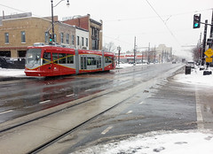
Red stripes next to streetcar tracks indicate where it’s unsafe to pass stopped cars. They’re installed wherever the tracks cross traffic lanes. Photo by Sean Emerson.

The complete list of 33 fixes is detailed below.

The list comes via an independent report from the American Public Transportation Association (APTA). The recommendations are a mix of back-end organizational issues and physical problems with the line’s construction.

The final report confirms the APTA’s preliminary finding from this spring, that none of the problems are fatal flaws. All 33 items on the list are fixable.

DDOT has been working on fixes for months

DDOT has yet to comment on the status of fixes, but it’s clear the agency has been working on them.

For example, one item on the list notes that streetcar doors scrape against some station platforms when they open. Last month, DDOT began modifying platforms to correct this problem.

Another example is the thick lines of red paint that DDOT added at key locations along H Street this spring. The paint is a visual warning for when the streetcar tracks swerve across travel lanes (like when they shift from the left lane to the right lane at Benning Road and Maryland Ave). If a car is inside the painted area at the track crossing, the streetcar doesn’t have room to pass safely.

The complete list

The full 33-item list comes in two parts: The first 18 items are from the preliminary findings that came out in March. Following that, there are 15 new items.

Here they all are:

18-item preliminary list

  1. In conducting safety certification, the DC State Safety Oversight office should allow flexibility in resolving problem issues. Workarounds that adequately resolve safety issues may be considered acceptable as temporary fixes, provided DDOT identify a plan for permanent solutions.

  2. Hire a qualified chief safety officer.
  3. Hire additional technical staff with more experience in light rail / streetcar construction and operating.
  4. Repair breaks in the streetcar rails at three locations.
  5. Ensure the six railcars are all in a state of good repair, including railcar #202 which caught fire in February, 2015.
  6. Investigate why streetcar doors scrape at stations, and fix the problem.
  7. Add more prominent pavement graphics indicating where streetcars stop at stations, and add pavement graphics at switch points and passing locations to indicate to streetcar operators when it’s safe to pass another streetcar.
  8. Ensure all on-board radios are working.
  9. Add additional lighting at streetcar stations.
  10. Complete a new safety assessment.
  11. Hire an independent expert to ensure compliance with the Americans with Disabilities Act (ADA). Specifically, have this expert review and if necessary correct the design of the rumble strips at station platforms.
  12. Train maintenance staff more thoroughly, so they’ll catch problems such as rail cracks sooner.
  13. Develop a pre-revenue operations plan, and do additional streetcar testing after all right-of-way and vehicle issues are resolved.
  14. Add heaters to rail switches, so they can melt snow pack.
  15. Resolve items from the previous safety & security reports.
  16. Develop a centralized tracking system for managing and resolving problems. DDOT’s current system is decentralized and results in oversights.
  17. Review documents describing operating & maintenance procedures, and correct inconsistencies and incomplete sections.
  18. Develop an opening day operating schedule.

15-item followup list

Items 19-26 all deal with recommendations for back-end reorganization of DDOT’s streetcar office. Most notably, APTA recommends DDOT appoint a single dedicated project manager with authority to make decisions, and delegate additional specific decision-making authorities to other designated staff. Currently all decisions are being elevated to the DDOT director, causing delays and leading to a lack of clarity regarding who is responsible for fixing problems.

  1. Conduct team building exercises to help streetcar staff work together better.

  2. Replace streetcar side mirrors with rear-facing cameras, reducing the width of the streetcars and thus reducing the risk of scraping parked cars.
  3. Ensure pedestrians on the south side of the Hopscotch Bridge have a safe and clearly-marked path. At the time of the APTA review, construction of Station House DC was blocking the sidewalk and stranding pedestrians.
  4. Add additional protection for pedestrians at the foot of the stairway at the Benning Road entrance to the streetcar carbarn, where a stairway terminates directly into the streetcar tracks.


    Photo from DDOT.

  5. Install a fence or landscaping along the street to prevent jaywalking.
  6. Add larger signs and additional on-street stencils warning car drivers to park inside the white line.
  7. Add bigger streetcar speed and signal signs. Current signs are too small for streetcar operators to see.

 Comment on this at the version cross-posted to Greater Greater Washington.


July 9th, 2015 | Permalink
Tags: streetcar, transportation


Breaking: Review says H Street Streetcar will be able to open

An outside review of the H Street Streetcar found no fatal flaws in the project that would prevent it from opening.

The American Public Transportation Association’s (APTA) peer review of the streetcar on “whether there’s a pathway to passenger service” is in, and the answer is yes, the streetcar can open.

In its letter to DDOT, APTA recommends a list of additional training and new procedures for the streetcar, but none appear to be major problems. The list includes more training for maintenance staff, reviewing operations and maintenance procedures, and augmenting DDOT staff with more experienced personnel.

DDOT is now analyzing the results and establishing a schedule to complete the recommendations.

There is still no opening date for streetcar passenger service, but it appears likely that question is now one of “when” rather than “if.”

 Cross-posted at Greater Greater Washington.


March 20th, 2015 | Permalink
Tags: streetcar, transportation


The Dutch government is trolling DC over marijuana, bike lanes, and streetcars

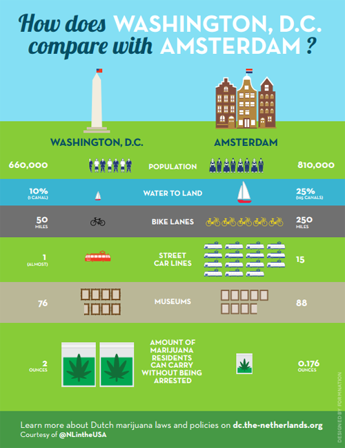
As marijuana legalization took effect in the District of Columbia, Mayor Muriel Bowser said DC would “not become like Amsterdam.” We talked about the differences yesterday, including on bicycling and transit, but the Embassy of the Netherlands has playfully responded with this infographic comparing our two capital cities.


Image from the Dutch government. Really.

The embassy also created a Q&A comparing marijuana laws in the two cities. But bicycling and transit supporters might focus more on the bike lane and streetcar disparities.

That “(almost)” hurts. Low blow, Netherlands.

 Cross-posted at Greater Greater Washington.


February 27th, 2015 | Permalink
Tags: bike, fun, streetcar, transportation


DC like Amsterdam? We can only hope

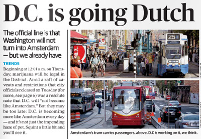
According to yesterday’s Express, DC is starting to look a lot like Amsterdam, and not just because of marijuana. That’s fantastic if true.


The top of yesterday’s Express story.

Among the reasons the Express cites for DC’s Amsterdamization are increasing bicycle use, the appearance of streetcars, and Georgetown’s improving C&O Canal.

Amsterdam is one of the world’s great bicycling and streetcar cities. It’s a joy to travel along its extensive bikeways, and even lanes where cars are allowed are amazingly bike friendly. And Amsterdam’s huge streetcar network (with streetcars in both dedicated lanes and mixed traffic) is a case study in successful urban transit.

DC’s nascent bikeway and streetcar networks pale in comparison, but Amsterdam is a superb model for us to aspire towards.

And if it’s true that we can never hope to have as many canals (short of a disastrous global warming-induced flood), we can at least ponder what might have been had the history of Constitution Avenue turned out differently.

Even more similarities

Transportation and canals aside, Amsterdam’s overall urban design is actually incredibly similar to DC’s. We’re both predominantly rowhouse cities, with plenty of brick. Even our street grids are similar: Amsterdam has a relatively small core with twisty medieval streets, but for the most part it’s a city of straight streets and radial avenues just like DC.

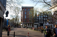
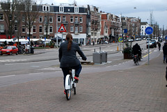
These scenes from Amsterdam wouldn’t look all that out of place in Dupont Circle, U Street, or Adams Morgan, apart from how little street space goes to cars..

 
Amsterdam, but could be DC.

Admittedly, Amsterdam beats DC in a lot of ways. But it’s not Paris or Hong Kong, not so thoroughly alien. And DC is not Las Vegas. Amsterdam and DC aren’t identical, but we’re the same species of city, which means Amsterdam is better in ways that DC can practically emulate.

Plus, we’ve got Amsterdam Falafelshop.

 Cross-posted at Greater Greater Washington.


February 26th, 2015 | Permalink
Tags: architecture, bike, streetcar, transportation, urbandesign


Where to go wireless: The next big streetcar question

Now that DC’s oft-delayed H Street streetcar is hopefully near opening, DDOT officials are planning the next wave of lines. One of the biggest emerging questions (besides the role of dedicated lanes) is where the streetcars should run without wires.


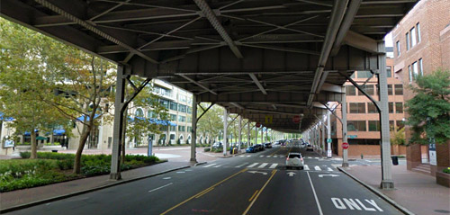
Current law prohibits wires under the Whitehurst Freeway. Should that change? Image from Google.

DC has important monumental views that wires could impact. Therefore, DDOT has been promising hybrid streetcars that can run off-wire for part of their route since 2009. It could mean wires along some roads but not at major intersections, crossing state avenues, or across the National Mall, for example.

DC Councilmember Mary Cheh is convening a public hearing today to discuss the question with District Department of Transportation (DDOT) officials including new director Leif Dormsjo.

Where wires are legal

Current DC law prohibits overhead wires in the central L’Enfant city (basically everything between Florida Avenue and the Anacostia River) and Georgetown, except on H Street. In 2010, the council exempted H Street from the law, specifically to permit streetcars there.

But only exempting H Street was never a permanent solution. It was a stopgap to let H Street move forward while giving DDOT time to study wire-free planning in more detail. Now it’s time for a broader plan.


Wires on H Street.

Is wireless technology ready?

The 2010 law also required DDOT to study wireless streetcar technology before building any other lines, so leaders could make an informed decision about other exemptions.

DDOT completed that study in mid-2014, and in it concluded that off-wire technology is still only practical for short distances. Batteries, ground-based power supplies, and various other wire-free systems do exist, but they’re vastly more expensive and vastly less reliable than traditional overhead wires. Hybrid streetcars that operate on-wire part of the time, and off-wire at other times, remain by far the best option.

Moving forward, the DC Council could opt to change the wire law in one of four ways: 1) Keep the existing law allowing wires only outside the core; 2) Prohibit wires everywhere; 3) Allow wires everywhere; or 4) Allow wires in certain additional locations, but not others.

DDOT’s report proposes an approach in line with option 4:

In the near term, proven overhead contact system (OCS)-based technologies will form the basis of the system, with limited application of off-wire technologies in the most sensitive areas to the extent possible. As technologies advance, the amount of off-wire operations will be gradually increased.

This option makes sense. Most people agree that the north-south streetcar line should be wireless when it crosses the National Mall, but it would be absurd to demand the K Street line be wire-free when it runs under the Whitehurst Freeway.

Others worry that DDOT will not actually “gradually increase the amount of off-wire operations” once wires are in the ground. If DC buys streetcars that can handle only limited off-wire operation, it would cost money to upgrade, and that might not happen for a long time.

But wire-free technology still only works for short distances, so a hybrid is still the way to go. Modern streetcar wires can be relatively unobtrusive and won’t mar the streetscape. Allowing overhead wires in some other areas while prohibiting them in the most sensitive spots is the rational solution.

 Cross-posted at Greater Greater Washington.


February 4th, 2015 | Permalink
Tags: events, preservation, streetcar, transportation


Dormsjo says no more arbitrary deadlines for DC Streetcar

DDOT Director Leif Dormsjo says he’s hitting the reset button on the often-delayed H Street streetcar.

What that really means: Safety certification will continue, but DDOT won’t announce any more opening dates until they’re sure. And Dormsjo will reorganize DDOT’s streetcar management team.

Several times under former Mayor Grey, DDOT announced potential opening dates for the streetcar. But in all cases those dates were goals, and at least some of them were clearly based on political wishful thinking. But the public perceived them as solid deadlines, and missing them has contributed to souring public support for the project.

Now, Dormsjo says that’s over. DDOT will no longer make public predictions about the coming opening date. That’s probably good news.

On the other hand, there’s a lack of trust between DDOT and the public right now, and clamping up entirely will not repair it. It’s well and good for DDOT to cease making poor predictions, but “trust us, we’re working on it” won’t be a satisfactory answer for long.

What sort of reorganization Dormsjo has in mind is not yet public info.

WAMU reporter Martin DiCaro is live-tweeting streetcar news today, and will likely have the full story later.

 Cross-posted at Greater Greater Washington.


January 16th, 2015 | Permalink
Tags: streetcar, transportation


How to tell the difference between streetcars and light rail

There is much confusion over what separates streetcars from light rail. That’s because there’s no single easy way to tell, and many systems are hybrids. To tell the difference, one has to simultaneously look at the tracks, train vehicles, and stations.
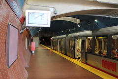
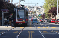
San Francisco’s Muni Metro runs both in a dedicated subway and on the street in mixed traffic.
Is it a streetcar or light rail system?
Photos by Matt Johnson and SFbay on Flickr.

It’s hard to tell the difference because streetcars and light rail are really the same technology, but with different operating characteristics that serve different types of trips.

The difference, in a nutshell

Theoretically light rail is a streetcar that, like a subway or el, goes faster in order to serve trips over a longer distance. But what does that mean in practice?

There are several features of tracks, vehicles, and stations that both streetcars and light rail sometimes have, but which are generally more common on light rail. Thus, although there’s no single separating test that can tell the two apart with 100% accuracy, it’s usually possible to tell the difference by looking at several factors simultaneously.

Let’s look at each of those factors, one by one.

Lanes and tracks

It’s a common misconception that streetcars always run in mixed traffic with cars, while light rail has its own dedicated track space. That’s often true, and it’s such a convenient and easy-to-understand definition that I’ve been guilty of using it myself. But it’s wrong.

There are too many exceptions to that rule to rely on it completely. Sometimes (though rarely) light rail lines run in mixed-traffic, and there are plenty of streetcars with their own right-of-way. Some streetcars even have subways.

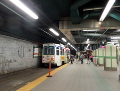
Compare Sacramento’s mixed-traffic light rail with Philadelphia’s streetcar subway, for instance:
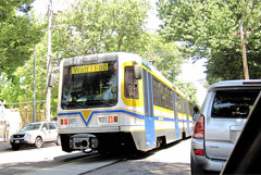
Left: Sacramento light rail in mixed traffic. Photo by Flastic on Wikipedia.
Right: Philadelphia streetcar in a subway. Photo by John Smatlak via Flickr.

In fact, practically every mixed-traffic streetcar has at least a short section of dedicated track. That’s true in Atlanta, Seattle, Tucson, even DC. Those streetcar lines don’t suddenly become “light rail” for one block just because they have a dedicated lane somewhere. It’s just not that simple.

And some streetcars have long stretches with dedicated lanes. Toronto’s massive streetcar network has several dedicated transitways, and DC is planning one on K Street.
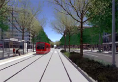
Left: K Street transitway. Image from DC Streetcar.
Right: Toronto’s Saint Clair transitway. Photo by Sean Marshall via Flickr.

There are too many streetcars with dedicated lanes for that to be a reliable indicator on its own. Too many lines that mix dedicated and non-dedicated sections. Certainly it’s an important data point; certainly it’s one factor that can help tell the difference. But it’s not enough.

An even simpler definition might be to call anything with tracks in the street a streetcar, and anything with tracks elsewhere light rail.

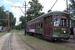
But that’s not reliable either, as Portland and New Orleans illustrate:
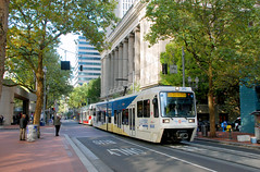
Left: Portland light rail. Photo by BeyondDC.
Right: New Orleans streetcar. Photo by karmacamilleeon via Flickr.

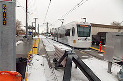
Salt Lake City muddies the water still further. Its “light rail” mostly runs in the street, while its “streetcar” runs in an old freight train right of way, almost completely off-street.
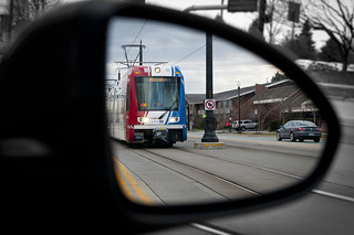
Left: Salt Lake City light rail. Photo by VXLA on Flickr.
Right: Salt Lake City streetcar. Photo by Paul Kimo McGregor on Flickr.

Vehicles and trains

If tracks on their own aren’t enough to tell the difference, what about vehicles?

It’s tempting to think of streetcars as “lighter” light rail, which implies smaller vehicles. Sometimes that’s true; a single DC streetcar is 66 feet long, compared to a single Norfolk light rail car, which is over 90 feet long.

But not all streetcars are short. Toronto’s newest streetcars are 99 feet long.
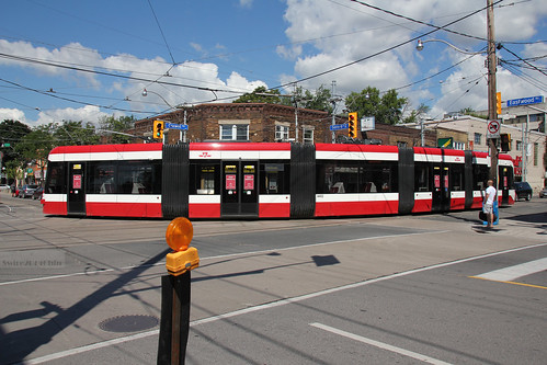

Toronto streetcar. Photo by Swire on Flickr.

In fact, many light rail and streetcar lines use the exact same vehicles. For example, Tacoma calls its Link line light rail, and uses the same train model as streetcars in Portland, DC, and Seattle, while Atlanta’s streetcar uses the same train model as light rail in San Diego, Norfolk, and Charlotte. And Salt Lake City uses the same train model for both its streetcar and light rail services.
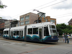
Left: Tacoma light rail. Photo by Marcel Marchon via Flickr.
Right: Portland streetcar. Photo by Matt Johnson on Flickr.

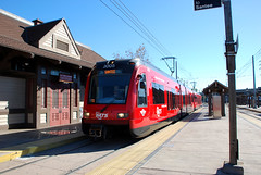
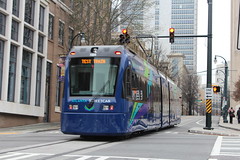
Left: San Diego light rail. Photo by BeyondDC.
Right: Atlanta streetcar. Photo by Matt Johnson via Flickr.

And although streetcars often run as single railcars while light rail often runs with trains made up of multiple railcars, there are exceptions to that too.

San Francisco’s Muni Metro and Boston’s Green Line definitely blur the line between streetcar & light rail, perhaps more than any other systems in North America. Some might hesitate to call them streetcars. But they both run trains in mixed-traffic with cars, and some of those trains have multiple railcars.

Meanwhile, many light rail systems frequently run single-car trains, especially during off-peak hours.
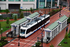
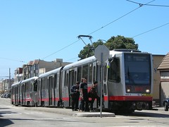
Left: Norfolk light rail with a single car. Photo by BeyondDC.
Right: San Francisco streetcar with two cars. Photo by Stephen Rees via Flickr.

Stations offer some help, but no guarantee

Light rail typically has bigger stations, while streetcars typically have smaller ones. A big station can sometimes be a good clue that you’re likely dealing with light rail.

For example, look at Charlotte and Portland:
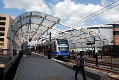
Left: Charlotte light rail. Photo by BeyondDC.
Right: Portland streetcar. Photo by BeyondDC.

But that’s only a general guideline, not a hard rule. Just like tracks and vehicles, there are many exceptions. Light rail often has small stops, and streetcar stations can sometimes get pretty big (especially when they’re in a subway).

This light rail stop in Norfolk is smaller than this streetcar stop in Philadelphia, for example:
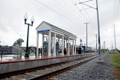
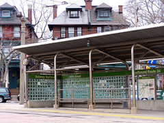
Left: Norfolk light rail. Photo by BeyondDC.
Right: Philadelphia streetcar. Photo by BeyondDC.

Stop spacing and route length

Probably the most reliable way to tell streetcars apart from light rail is to look at where the stations are located. Light rail lines typically have stops further apart from each other, on lines covering a longer distance.

This chart explains the difference:
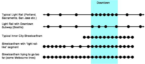

Image from Jarrett Walker.

This is the definition transit expert Jarrett Walker favors, and if you have to pick just one or two factors to consider, stop spacing and route length are the best.

But even this is no sure way to categorize all lines as either streetcars or light rail. It might be easy to tell the difference between something with stops one block apart (theoretically streetcar) versus stops two miles apart (theoretically light rail), but what if the stops are 1/4 mile apart? Or what if the gaps aren’t consistent? There’s no clear place to draw the line.

Furthermore, Walker’s graphic itself illustrates exceptions to the rule. The top line shows a light rail route with stops close together downtown, the third line shows a streetcar with some sections that have far-apart stations, and the fourth line shows a very long streetcar.

There are certainly plenty of real-life examples of those exceptions. Before Arlington, VA cancelled its Columbia Pike streetcar, DC and Arlington were considering linking their streetcars with a bridge over the Potomac River. Had that happened, there might have been a mile-and-a-half between stops.

Certainly station spacing and route length provide a convenient general rule, but only that. There’s no hard boundary where everything to one side is streetcar, and everything to the other is light rail.

To really know the difference, look at everything

There are seven factors that light rail usually has, but that streetcars only sometimes share: Dedicated lanes, off-street tracks, bigger vehicles, multi-car trains, longer routes, bigger stations, and long distances between stations.

No single one of them provides a foolproof litmus test, because sometimes streetcars have each of them, and sometimes light rail doesn’t. But if you look at all seven together and determine which direction the majority of a line’s characteristics point, over the majority of its route, then you can usually sort most lines into one category or the other.

For example, DC’s H Street line fits neatly into the streetcar category, because it runs in the street almost totally in mixed traffic, with small vehicles on single-car trains, along a short route that has frequent, small stations. Even if DDOT builds the K Street transitway and a dedicated-lane streetcar on Georgia Avenue, the majority of the seven factors will still point to streetcar.

On the other end of the spectrum, Seattle’s Central route is squarely light rail. It has a dedicated right-of-way that’s often off-street, uses large 95 foot-long vehicles that are usually coupled into multi-car trains, along a long route with infrequent stations.
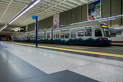
Left: Seattle light rail. Photo by Atomic Taco on Flickr.
Right: DC streetcar. Photo by BeyondDC.

But even then not every system is crystal clear. San Francisco’s Muni Metro, Philadelphia and Boston’s Green Lines, and Pittsburgh’s T, for example, all have some segments that look like classic streetcars, but also some segments that look like classic light rail. These networks defy any characterization, except as hybrids.

It’s a feature, not a bug

The fact that it’s hard to tell the difference is precisely why so many cities are building light rail / streetcar lines. The technology is flexible to whatever service characteristics a city might need.

You can use it to build a regional subway like Seattle, or you can use it for a short neighborhood circulator like DC’s H Street, or anything in-between. And perhaps even more importantly, you can use it to mix and match multiple characteristics on the same line, without forcing riders to transfer.

That’s why many of the most successful light rail / streetcar systems are the hardest ones to categorize as either / or. They match the infrastructure investment to the needs of the corridor, on a case-by-case basis, and thus have some sections that look like light rail, and others that look like streetcar.

That’s not muddied. That’s smart. That’s matching the investment to the need, which is after all more important than a line’s name.

 Cross-posted at Greater Greater Washington.


January 13th, 2015 | Permalink
Tags: lightrail, streetcar, transportation


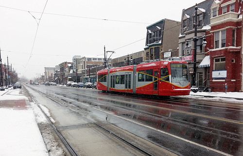
Well, the streetcar works in the snow

Today’s snow made for at least one happy side effect: The H Street streetcar got an opportunity to test operations in challenging weather. So far, it seems to be working smoothly.

This is no surprise. Toronto has the largest streetcar network in North America, and streetcars there handle snow just fine.

Of course, the real test will come when the streetcars begin to carry passengers, hopefully around January 19.

 Cross-posted at Greater Greater Washington.


January 6th, 2015 | Permalink
Tags: streetcar, transportation


Amsterdam plays spot the Christmas streetcar

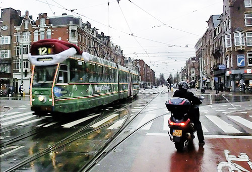
Remember #bikeinbloom, when Capital Bikeshare dressed one of its bikes up in cherry blossom regalia? Every Christmas, Amsterdam does the same thing with one of its famous streetcars.

Amsterdamers call it the “kersttram”, or “Christmas tram.”


Photo from Alexander Meijer on Flickr.

Amsterdam isn’t alone. Other cities around the world partake in the same fun with their own trams. Among them: Budapest, Zurich, and San Francisco.

How about it, DDOT? Maybe next year, when H Street is finally up and running?

 Cross-posted at Greater Greater Washington.


December 18th, 2014 | Permalink
Tags: fun, streetcar, transportation


Visible progress on the Crystal City transitway

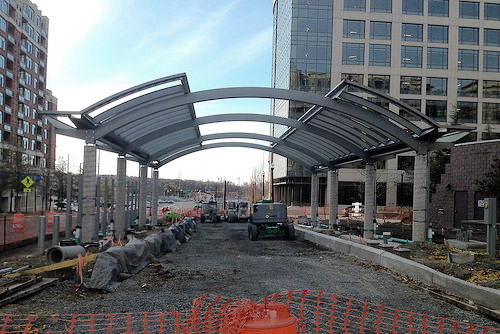
Arlington’s Crystal City streetcar may have been canceled, but work is continuing on the dedicated transitway that would have carried it. Only buses will use this now, but the infrastructure is rising from the ground.

This is the Glebe Road station, in Potomac Yard.


Glebe Road station. Photo by Arlington.

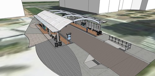
When complete, it will look like this:


Station rendering. Image by Arlington.

 Cross-posted at Greater Greater Washington.


November 28th, 2014 | Permalink
Tags: BRT, streetcar, transportation


Media


Site
About BeyondDC
Archive 2003-06
Contact

Search:

GoogleBeyondDC
Category Tags:

Partners
 
  Greater Greater Washington
 
  Washington Post All Opinions Are Local Blog
 
  Denver Urbanism
 
  Streetsblog Network


BeyondDC v. 2013d | Email | Archive of posts from 2003-2006