|
Special Features


Image Libraries


|
|
Blog
Video proof neon clothes don’t stop careless drivers from driving into peopleHave you ever seen a traffic safety campaign that reprimands you for not wearing bright colors every time you cross the street? Of course you have. Here’s video proof that’s a load of bollocks.
In this viral video, a careless SUV driver rolls into a neon-clad police officer. There’s no ambiguity as to who’s at fault. The officer was stopped still, in broad daylight, and wearing the holy grail of bright clothes: a reflective vest. The SUV driver simply didn’t stop when he or she should have. Thankfully it all happens at slow speed, so it doesn’t appear the officer was hurt.
But this is a clear illustration of why it’s wrong to lecture pedestrians about wearing bright colors. It’s not reasonable to demand that everyone wear bright yellow every time they’re outside a car. But it is absolutely reasonable to demand that drivers not carelessly drive into people, no matter what anyone is wearing.
 Comment on this at the version cross-posted to Greater Greater Washington. Comment on this at the version cross-posted to Greater Greater Washington.
October 15th, 2015 | Permalink
Tags: bike, pedestrians, roads/cars, transportation

Fairfax City will install its first bike laneThere will soon be a bona fide bike lane between downtown Fairfax and George Mason University, the first in Fairfax City.

Fairfax City’s first bike lane, location map and proposed design. Images from the City of Fairfax.
On September 29, the Fairfax City Council approved a one year pilot program to test a three block bike lane on University Drive, the street that connects downtown Fairfax to the largest university in Virginia.
The bike lane will begin just south of downtown Fairfax, and will run south as far as Armstrong Street. There, it will meet George Mason Boulevard, where Fairfax installed its first sharrows a few years ago.
Crews will restripe University Drive this autumn, to change its configuration from having two car lanes in each direction, to having one car lane each way, a central turn lane, and bike lanes next to each curb.
A baby step
This bike lane, and its associated road diet, is a nice baby step for a community that’s never given bikes much thought.
But a baby step it is. Not only did officials promise to reevaluate and possibly remove the bike lane after one year, but they significantly shortened it from the original proposal.
At one point, planners had hoped to stripe the bike lane north through downtown Fairfax, as far as Layton Hall Drive. Unfortunately, that was a no-go.

Map of the approved bike lane, canceled portion, and existing sharrows. Map by the author, using base map from Google.
A natural location
Fairfax City isn’t a big community. It’s located roughly between I-66 and George Mason University, and its historic downtown is one of the more walkable places in Northern Virginia outside the Beltway.
With a walkable downtown and a big university, it’s a natural for better bike infrastructure.
Unfortunately, decades of suburban road design have left most of Fairfax City just as car-dependent as surrounding Fairfax County. Now, that’s beginning to change. But ever so slowly.
Comment on this at the version cross-posted to Greater Greater Washington.
October 13th, 2015 | Permalink
Tags: bike, transportation
Copenhagen proves bikes can work in the suburbsOne common criticism of bicycling is that it’s all well and good for dense core cities, but isn’t a serious transportation option in suburban areas. Suburbs in other countries prove that’s wrong.
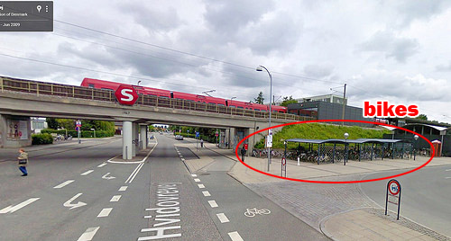
Bike parking at Friheden Street transit stop in suburban Copenhagen. Photo from Google.
The photo above is from Friheden Street station, in suburban Copenhagen. And look at all those beautiful bike racks. How did they get there?
One of the most important uses for bicycles is as a last mile tool, to get from one’s home to a transit station, or from a transit station to one’s final destination.
Anywhere you have a transit station with a lot of other buildings a mile or two away, bikes can help connect one to the other. That includes suburbs.
If you provide the necessary infrastructure, and treat bicycling like a serious option, people will use it.
Yes, that’s a suburb
Unlike central Copenhagen, which is dense and difficult to drive a car through, the area around Friheden Street is suburban and relatively low density. Actually it looks a lot communities around the Washington Beltway.
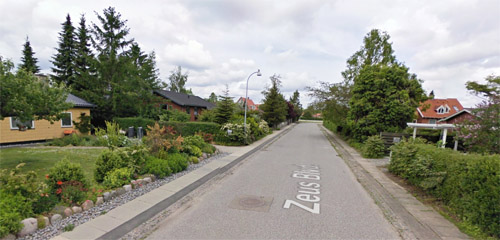
Residential Friheden. Photo from Google.
Compare these two aerial photos, taken at about the same scale. The first image shows the area around Friheden Street station. The second shows Kensington, in suburban Washington.
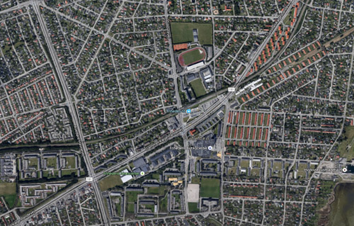
Suburban Copenhagen. Photo from Google.
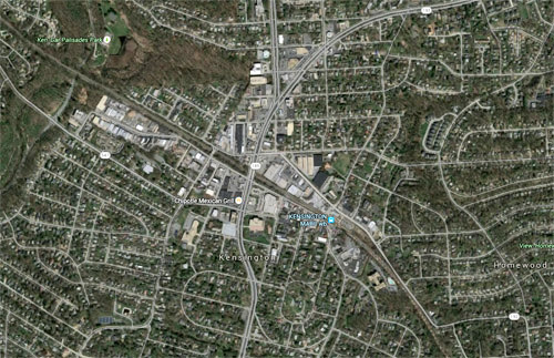
Suburban Washington. Photo from Google.
They look pretty analogous. Not exactly the same, to be sure; Friheden has a few apartment buildings sprinkled in, and its S-train station offers better service than Kensington’s MARC station. But they’re not so dissimilar as to be completely alien. They’re siblings, if not quite twins.
I admit I’ve never been to Friheden Street. I’ve never even been to Denmark. Frankly I have no idea if it’s a pleasant community, or what the less desirable things about it may be. I’m sure there are trade-offs to it, compared to an American suburb.
But I happened to be on Google Earth looking at Copenhagen, which is famously a bike paradise, and wondered what its suburbs look like. I turned on Google’s transit layer and started looking at the areas around suburban stations. Friheden Street just happens to be one I zoomed in on.
And look at all those beautiful bike racks.
Comment on this at the version cross-posted to Greater Greater Washington.
August 31st, 2015 | Permalink
Tags: bike, transportation
Crowdsource safety problems on DC streets with this interactive Vision Zero mapDo you know of a safety problem on a DC street? If so, tell DDOT about it using the interactive Vision Zero map. It allows residents to click a location and type in notes to describe problems.

Image from DDOT.
This new map is part of DC’s Vision Zero Initiative, which aims to eliminate all fatalities and serious injuries in the transportation system.
The map lets you add notations for a wide variety of safety problems. There are separate categories for driver, pedestrian, and cyclist problems, with several options available for each. You can also scroll around DC to see what your neighbors have submitted.
It’s a neat tool. I’ve already submitted a handful of problems.
Comment on this at the version cross-posted to Greater Greater Washington.
July 1st, 2015 | Permalink
Tags: bike, pedestrians, roads/cars, transportation
CaBi cures downtown dockblocking with new bike corralsOne of the biggest problems limiting growth of Capital Bikeshare in DC has been that downtown docks fill up early in the morning rush hour. That won’t be a problem after Thursday, when two new bikeshare corrals open, offering unlimited bikeshare parking.
Bike corral at the 2013 Obama inauguration. Photo by jantos on Flickr.
The two parking corrals will be at 13th and New York Avenue near Metro Center, and at 21st and I near Foggy Bottom. Once the regular bike docks fill up, a Capital Bikeshare staffer will be on hand to accept bikes and log out riders.
The bike corrals will be open every weekday morning this summer, beginning Thursday, May 14, and ending in September. If the service proves popular, CaBi may extend it into autumn.
Corrals will only be open during the morning rush hour, and only at those two locations.
Bigger redistribution truck
The corrals aren’t the only Capital Bikeshare improvement coming this week. The agency has also acquired a larger redistribution van, allowing them to move bikes from full stations to empty ones more quickly.
There’s no word yet on just how big the new bigger redistribution van is, but check out what Montreal uses:
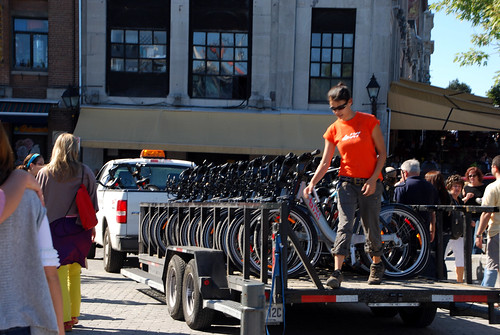
Montreal redistribution truck.
Hooray for more reliable bikeshare!
Cross-posted at Greater Greater Washington.
May 12th, 2015 | Permalink
Tags: bike, transportation
A bikeable suburban highway? One Ohio town pulled it offWide suburban highways lined with big boxes and strip malls aren’t usually places one finds protected bikeways. But Stringtown Road in Grove City, Ohio is such a place. Check it out:
Stringtown Road.
Since a curb protects the bikeway from the road, it’s technically a sidepath, a sidewalk that’s for bikes instead of pedestrians.
And as you can see in photos from Google Street View, it’s nicer than riding in the street with fast-moving cars, but it’s still not exactly pleasant.
Huge curb cuts interrupt the bikeway, so cars don’t need to slow down much before pulling into the giant parking lots lining the road. There’s certainly a risk that careless drivers will turn without watching, and hit people on bikes.
But that’s a risk that will exist for any car-oriented highway. At least this one puts the bike lane front and center, just about as visible as it can be.
There are some sidepaths along large roads in the DC area, like Route 50 in Arlington or along Benning Road near RFK, but those aren’t commercial highways lined with shops, and their sidepaths aren’t right against the curb like Stringtown’s. This particular layout is pretty unusual.
As more and more suburban communities evolve to become more multimodal, experiments like this will help everyone around the country understand what works and what doesn’t. Grove City is near Columbus, where it’s not the only suburb experimenting with urban retrofits.
What do you think? Will this design work? Comment at Greater Greater Washington to talk about it.
Cross-posted at Greater Greater Washington.
March 27th, 2015 | Permalink
Tags: bike, transportation, urbandesign
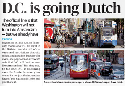
The Dutch government is trolling DC over marijuana, bike lanes, and streetcarsAs marijuana legalization took effect in the District of Columbia, Mayor Muriel Bowser said DC would “not become like Amsterdam.” We talked about the differences yesterday, including on bicycling and transit, but the Embassy of the Netherlands has playfully responded with this infographic comparing our two capital cities.
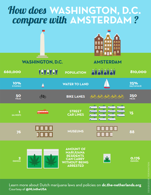
Image from the Dutch government. Really.
The embassy also created a Q&A comparing marijuana laws in the two cities. But bicycling and transit supporters might focus more on the bike lane and streetcar disparities.
That “(almost)” hurts. Low blow, Netherlands.
Cross-posted at Greater Greater Washington.
February 27th, 2015 | Permalink
Tags: bike, fun, streetcar, transportation
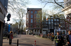
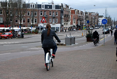
DC like Amsterdam? We can only hopeAccording to yesterday’s Express, DC is starting to look a lot like Amsterdam, and not just because of marijuana. That’s fantastic if true.
The top of yesterday’s Express story.
Among the reasons the Express cites for DC’s Amsterdamization are increasing bicycle use, the appearance of streetcars, and Georgetown’s improving C&O Canal.
Amsterdam is one of the world’s great bicycling and streetcar cities. It’s a joy to travel along its extensive bikeways, and even lanes where cars are allowed are amazingly bike friendly. And Amsterdam’s huge streetcar network (with streetcars in both dedicated lanes and mixed traffic) is a case study in successful urban transit.
DC’s nascent bikeway and streetcar networks pale in comparison, but Amsterdam is a superb model for us to aspire towards.
And if it’s true that we can never hope to have as many canals (short of a disastrous global warming-induced flood), we can at least ponder what might have been had the history of Constitution Avenue turned out differently.
Even more similarities
Transportation and canals aside, Amsterdam’s overall urban design is actually incredibly similar to DC’s. We’re both predominantly rowhouse cities, with plenty of brick. Even our street grids are similar: Amsterdam has a relatively small core with twisty medieval streets, but for the most part it’s a city of straight streets and radial avenues just like DC.
These scenes from Amsterdam wouldn’t look all that out of place in Dupont Circle, U Street, or Adams Morgan, apart from how little street space goes to cars..
Amsterdam, but could be DC.
Admittedly, Amsterdam beats DC in a lot of ways. But it’s not Paris or Hong Kong, not so thoroughly alien. And DC is not Las Vegas. Amsterdam and DC aren’t identical, but we’re the same species of city, which means Amsterdam is better in ways that DC can practically emulate.
Plus, we’ve got Amsterdam Falafelshop.
Cross-posted at Greater Greater Washington.
February 26th, 2015 | Permalink
Tags: architecture, bike, streetcar, transportation, urbandesign
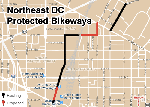
DC streets will get seven new miles of bikeways in 2015DDOT has released a list of new bikeways it will add in 2015. Although most of the additions this year will be short, they’re important. This year’s work will specifically focus on closing gaps in the network, in order to make existing bike lanes more useful.
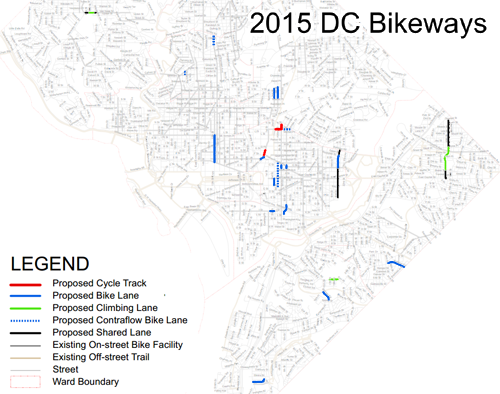
Planned bike lanes in 2015. Image from DDOT.
In total there are about seven miles of new bikeways on the list, including three short protected bikeways, about four miles of striped bike lanes, and two miles of sharrows.
According to DDOT’s Darren Buck, “We’re hoping to address several short but valuable network connection links that are easy to overlook on a map, but people have been requesting for years.”
The new protected bikeways are all in Northeast, on M Street, 4th Street, and 1st Street. Collectively they’ll begin to stitch together Northeast’s existing patchwork of disconnected cycletracks into a more useful and cohesive network. An unprotected contraflow lane continuing along M Street will help that effort too.
Basemap from Google.
Besides the Northeast protected bikeways, other notable additions include a normal bike lane on 12th Street NW downtown, along with several east of the Anacostia and in Capitol Hill, and short but important connections on 11th Street NW, Ontario Road NW, 2nd and 3rd Streets NE, and crossing I-695.
This project list is separate from the list of ten car lane to bike lane conversions that came out in January. The bike lanes in January’s list are still in planning, and will likely happen in future years.
Here’s the complete street by street list of DDOT bike lane additions for 2015.
Cross-posted at Greater Greater Washington.
February 20th, 2015 | Permalink
Tags: bike, transportation
America’s largest bikesharing systems, ranked following 2014As US bikesharing continues to boom, it’s fun to look back each year and see how systems have grown. Now that we’re into the grind of 2015, let’s look back on 2014 and see what changed.
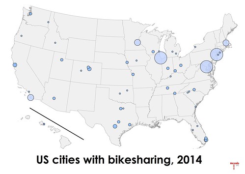
2014 was a modest year for US bikesharing expansion, compared to the incredible boom of 2013. Overall, the number of bikeshare stations nationwide increased about 20%, from 1,925 in 2013 to 2,345 in 2014. San Diego launched the largest new system, with 117 stations.
Washington’s Capital Bikeshare regained its crown as largest overall network, growing from 305 stations to 347 stations. Last year’s champ, New York’s Citibike, actually lost two stations and dropped from 330 to 328. Chicago rounds out the top tier, with the same number of stations it had last year: 300 exactly. No other system tops 200 stations.
14 new bikesharing systems opened nationwide, and four small existing ones closed, bringing the US total up to 50 active systems.
The west coast began to catch up to the rest of the country. In addition to San Diego, Seattle opened the next largest new system of 2014, with 49 stations.
Here’s the complete list of all US systems. New ones are marked in bold. Previous years are available for comparison.
| Rank |
City |
2013 Stations |
2014 Stations |
| 1 |
Washington (regional) |
305 |
347 |
| 2 |
New York |
330 |
328 |
| 3 |
Chicago |
300 |
300 |
| 4 |
Minneapolis (regional) |
170 |
169 |
| 5 |
Boston (regional) |
132 |
140 |
| 6 |
San Diego |
0 |
117 |
| 7 |
Miami Beach |
97 |
94 |
| 8 |
Denver |
81 |
83 |
| 9 |
San Francisco (regional) |
67 |
70 |
| 10 |
San Antonio |
51 |
53 |
| 11 |
Seattle |
0 |
49 |
| 12 |
Austin |
11 |
45 |
| 13 |
Boulder |
22 |
38 |
| 14(t) |
Fort Worth |
34 |
34 |
| 14(t) |
Miami |
0 |
34 |
| 16 |
Chattanooga |
33 |
33 |
| 17 |
Columbus |
30 |
30 |
| 18(t) |
Madison |
32 |
29 |
| 18(t) |
Cincinnati |
0 |
29 |
| 20 |
Houston |
29 |
28 |
| 21 |
Indianapolis |
0 |
26 |
| 22 |
Omaha |
8 |
25 |
| 23(t) |
Nashville |
22 |
24 |
| 23(t) |
Charlotte |
21 |
24 |
| 23(t) |
Phoenix |
0 |
~24 |
| 26 |
Ft Lauderdale (regional) |
25 |
21 |
| 27(t) |
Kansas City |
12 |
20 |
| 27(t) |
Salt Lake City |
12 |
20 |
| 29 |
Aspen |
12 |
15 |
| 30 |
Long Beach, NY |
13 |
14 |
| 31 |
Washington State Univ (Pullman, WA) |
9 |
11 |
| 32 |
Milwaukee |
0 |
10 |
| 33 |
Greenville, SC |
6 |
8 |
| 34(t) |
Oklahoma City |
7 |
7 |
| 34(t) |
Tampa |
0 |
~7 |
| 36(t) |
Des Moines |
6 |
6 |
| 36(t) |
Ann Arbor |
0 |
6 |
| 38 |
Univ of Buffalo (Buffalo, NY) |
4 |
5 |
| 39(t) |
California Univ – Irvine (Irvine, CA) |
4 |
4 |
| 39(t) |
Spartanburg, SC |
4 |
4 |
| 41(t) |
Tulsa |
4 |
3 |
| 41(t) |
Louisville |
3 |
3 |
| 41(t) |
Stony Brook Univ (Stony Brook, NY) |
3 |
3 |
| 44(t) |
Kailua, HI |
2 |
2 |
| 44(t) |
Roseburg VA Hospital (Roseburg, OR) |
2 |
2 |
| 44(t) |
Hailey, ID |
2 |
~2 |
| 44(t) |
Rapid City |
0 |
2 |
| 44(t) |
Savannah |
0 |
2 |
| 44(t) |
Dallas |
0 |
2 |
| 44(t) |
Orlando |
0 |
~2 |
|
Fullerton, CA (closed) |
10 |
0 |
|
Georgia Tech (Atlanta, Ga) (closed) |
9 |
0 |
|
George Mason Univ (Fairfax, VA) (closed) |
7 |
0 |
|
Lansing (closed) |
4 |
0 |
Systems marked with a ~ are stationless bikeshare networks, in which each bike contains a lock and can be docked anywhere. The number of “stations” reported for three of these four systems (Phoenix, Tampa, and Orlando) is approximate and is was calculated by dividing the overall number of bicycles by 8. The fourth system, Hailey, has only six bikes but they’re located in two distinct clusters, so it seems most appropriate to report two stations.
Counting the number of bikes rather than stations would be a more accurate way to rank systems, but that information is more difficult and time-consuming to obtain.
Cross-posted at Greater Greater Washington.
February 12th, 2015 | Permalink
Tags: bike, transportation
|
Media


Site
About BeyondDC
Archive 2003-06
Contact
Category Tags:
Partners
|


