|
Special Features


Image Libraries


|
|
Blog
See every Metro train and bus on one live mapThis map shows the real-time location for every WMATA bus and train in the Washington region. It’s a cool way to see how much transit is out there, and where it’s running right this second.

Every WMATA bus and train. Image from TRAVIC.
The map is called TRAVIC and was produced by the University of Freiburg. The Washington map was made using using open data from WMATA.
Although the Washington map shows only WMATA transit, the same website includes maps for dozens of cities all over the world. You can compare what transit is like in diverse places, from Albuquerque to Paris.
 |
 |
| Left: Albuquerque. Right: Paris. Images from TRAVIC. |
I’ll be staring at this a long time.
 Comment on this at the version cross-posted to Greater Greater Washington. Comment on this at the version cross-posted to Greater Greater Washington.
October 21st, 2015 | Permalink
Tags: bus, maps, metrorail, transportation

Metro’s inefficient info displays worsen train crowdingBy prioritizing elevator information rather than train arrivals on its platform displays, WMATA forces riders to make bad decisions. The result: inefficient use of sparse train capacity.
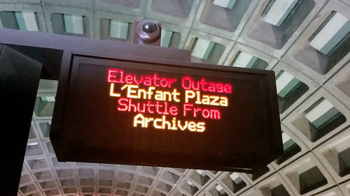
Not the best use of this technology.
Picture yourself in this scenario
Imagine you’re descending into a Red Line station. You hear a train approaching and rush to the platform. The train pulls up and you see that it’s full.
You glance over at the real-time train arrival display, hoping there will be another train a minute or two behind. If so, you’ll wait for it rather than crowd on now. Maybe you’ll have just enough time to move down the platform to a less crowded spot.
Alas, the display is cycling through elevator outages on the Orange Line in Virginia. Who knows how long until the next train arrives. You’d better crowd on now.
Prioritizing less important info results in badly informed riders
Scenarios like that play out thousands of times every day all over the Metrorail system. It happens because Metro’s PIDs, the Passenger Information Displays that show how long until the next train arrives, are programmed to also cycle through each elevator outage in the entire system.
Cycling through elevator outages often takes a long time, making it difficult for riders to get the real-time train arrival information that the displays were invented to show.
In turn, badly-informed riders can’t use the system efficiently, and exacerbate overcrowding. Without good information, riders push onto full trains when an empty one is a minute behind, and rush into the nearest door rather than move down the platform to a less crowded one.
Those are increasingly important problems given Metro’s capacity limitations.
Wheelchair users need elevator info
WMATA displays elevator outages on the PIDs because it’s crucial information for a small minority of riders: the wheelchair bound, and others who can’t use escalators or stairs.
For those groups, having plenty of advanced notice about which elevators are out is absolutely necessary. Removing that information from stations would therefore be an unacceptable trade-off.
But that information doesn’t have to be on the same screens as train arrival information. In fact, trying to display multiple elevator outages on the PIDs, where there’s only enough room to scroll through them one by one, is a remarkably bad way to provide that information.
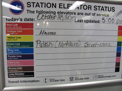
A better way, in Chicago. Photo by Matt’ Johnson on Flickr.
Displaying elevator outages on the PIDs requires riders who need that information to wait and watch an entire cycle, even if a train they could take is on the platform now.
It would be far more efficient to display that info on a separate screen that can show several outages at once, like the larger more advanced screens at station manager kiosks.
Or even a low-tech dry erase board, the preferred solution for Chicago’s CTA.
By trying to satisfy two entirely different sets of needs with one limited screen that runs on decades-old technology, WMATA isn’t getting as much out of the PIDs as it could.
Comment on this at the version cross-posted to Greater Greater Washington.
July 24th, 2015 | Permalink
Tags: metrorail, transportation
By 2019 it will have taken 34 years to build the Silver LineGiven how much Metrorail can transform a community, it’s little wonder communities want it to reach them. But planning and building new Metro lines is so politically and technically complex that it takes decades. Consider the Silver Line:

Slide from WMATA.
This slide showing a timeline of Silver Line planning and construction comes from a presentation WMATA planners Allison Davis and Kristen Haldeman gave at StreetsCamp this past Saturday.
The timeline begins in 1985, when the idea of a Metro line to Dulles Airport went from vague concept to serious planning initiative following a study that determined it would be feasible.
Planning (yellow on the timeline) and environmental work (green) took the next 21 years, until 2006. It took another 3 years for officials to finalize funding (blue) before construction (purple) could begin in 2009.
By the time the last segments open in 2019, it will have been 34 years.
Worth the wait, no doubt. But there’s bad news for other communities:
Plopping a rail line down the middle of a gargantuan suburban highway with a capacious median is easy compared to putting one virtually anywhere else. Almost any other potential Metrorail expansion imaginable will be harder to plan, fund, and build.
That doesn’t mean it’s not worth doing. But it’s definitely going to be hard.
Cross-posted at Greater Greater Washington.
June 26th, 2015 | Permalink
Tags: metrorail, transportation
When Metro’s busiest pinch point shut down today, what did you do?
|

Metro riders at Rosslyn this morning. Photo by @ABouknight on Flickr. |
Thousands of commuters faced gridlock at the peak of rush hour today when smoke at Foggy Bottom station forced Metro to close the crucial Rosslyn tunnel. With trains shut down and many alternatives overwhelmed by the flood of Metro riders, how did you cope?
What happened
Around 8:00 this morning, an insulator along the third rail between Foggy Bottom and Rosslyn Metro stations began giving off heavy smoke. From around 8:15 until about 11:15, WMATA suspended all Orange and Silver Line service between Virginia and DC. Blue Line trains diverted to the Yellow Line bridge.
The good news is nobody was hurt. The bad news was a hellish morning commute.
The Rosslyn tunnel is one of DC’s most crucial transportation pinch points. It’s one of the worst places for Metro to have to shut down service. And this morning’s event happened at the worst possible time, at the peak of rush hour, too late for WMATA to plan adequate backups, or for many commuters to seek alternate routes.
With no trains, and with buses, bikeshare, taxis, and roads overwhelmed by cast-off Metro riders, it was a particularly bad day.
How did you get to work?
My office is in Court House and I live in DC. Bikeshare wasn’t an option for me this morning, so my first thought was to take Metrobus 38B, aka the “Orange Line with a view”. But when I heard reports of how long lines were for buses, I figured the 38B would be uncomfortable at best.
Instead, I Metro-ed down the Yellow Line to the Pentagon and took ART 42 from there to my office. Happily, it was running on time and there were plenty of seats.
By the time I arrived at work, I’d been traveling an hour and a half. Bad, but not nearly as bad as many others.
How did you get in? Head over to the GGW version of this post and leave a comment.
Cross-posted at Greater Greater Washington.
May 11th, 2015 | Permalink
Tags: metrorail, transportation
In 1968, this brochure is how people learned about MetroWMATA adopted its initial plan for the Metrorail system in 1968. Between then and the beginning of construction in 1969, the agency published this brochure, to teach people about the coming system.

WMATA 1968 brochure. All photos from Reddit user Globalwrath.
Reddit user Globalwrath discovered the brochure, and it’s a fascinating trove of historic thinking.

The last benefit on this page sounds suspiciously like sprawl.

Note future options for suburban extensions in virtually every direction, and a subway under Columbia Pike in Arlington.

“The Metro will be among the best in the world.” And it was, when it was new.

What stands out to you?
Cross-posted at Greater Greater Washington.
May 4th, 2015 | Permalink
Tags: history, metrorail, transportation
San Francisco street lights will animate subway trains belowA public art installation on San Francisco’s Market Street will add animated lights following the movement of subway trains running directly below.
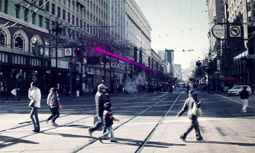
Image from Illuminate The Arts.
The project is called “LightRail,” and according to its sponsors it will be the world’s first “subway-responsive light sculpture.”
Two LED strings will stretch above Market Street for two miles through downtown San Francisco. Using real-time arrival data, the strings will visualize movement of BART and Muni trains directly underneath the street.
Sponsors hope LightRail will open in 2015, and will remain in place until at least 2018. If it proves popular, officials may decide to keep it up longer.
Without a doubt, this is one of the coolest public art projects I’ve ever seen.
Cross-posted at Greater Greater Washington.
December 17th, 2014 | Permalink
Tags: fun, lightrail, metrorail, transportation
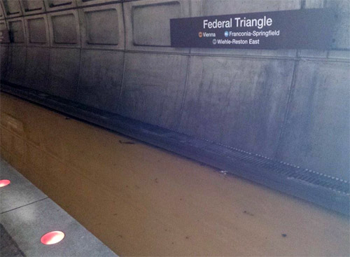
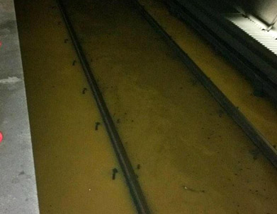
Metro’s flooded stations, in picturesThe water main break that temporarily flooded parts of Metrorail this morning was painful for commuters. These photos from Metro’s Twitter account show just how serious the flood became.
All photos from WMATA.
Metro’s third rail is eight inches high. It was fully covered by water.
The flood drained after DC Water shut off water flow. As the water receded, the tracks slowly became visible once more.
Hopefully that’s not an experience we’ll have to go through again any time soon.
Cross-posted at Greater Greater Washington.
December 16th, 2014 | Permalink
Tags: metrorail, transportation
For one day, Metro has a Pink LineFor Veteran’s Day festivities today, Metro is running an unusual service pattern, with no Blue Line. It’ll be rough for commuters, but neat for transit nerds. Why? Say hello to the Pink Line, for one day only.
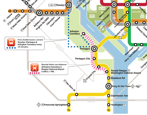
“Special trains” between Arlington Cemetery and National Airport, illustrated with pink. Original image from WMATA.
Without regular Blue Line trains, Metro is running this special Pink Line to provide service to Arlington Cemetery, which otherwise wouldn’t have any trains.
The map doesn’t actually include the words “Pink Line” anywhere, and trains running this route will probably simply be labelled “Special,” without any color.
But the map shows pink, so I think we can claim it.
Cross-posted at Greater Greater Washington.
November 11th, 2014 | Permalink
Tags: fun, metrorail, transportation
Keep it simple: Name Loudoun’s Metro stations “Sterling” and “Ashburn”Loudoun County is trying to come up with names for the two Metro stations west of Dulles that will open as part of the Silver Line Phase 2. Many of the options are terrible, but there’s an easy solution, and it looks like this:
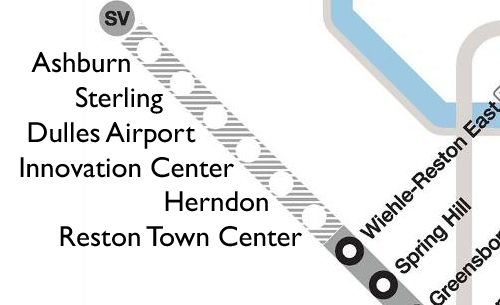
The “Route 606″ station is inside the Sterling zip code. The “Route 772″ station is inside the Ashburn zip code. Done. No more thought needed. Those names are perfect.
Names like “Loudoun Dulles North” and “Loudoun Gateway West” are not descriptive and they won’t engender any sense of place. Metro station names need to be as short and obvious as possible. “Sterling” and “Ashburn” meet that test, while the other options don’t. The KISS principle absolutely applies.
The only real criticism of Sterling or Ashburn seems to be that the center of Sterling is a little further north than this station. So what? Reston Town Center is a little further north of what will become Reston Town Center station. Vienna station isn’t actually in the Town of Vienna. And Branch Avenue station is actually on Old Soper Road. It doesn’t matter because these names are supposed to be general. They’re supposed to roll off the tongue and be easy for riders to remember.
This doesn’t need to be so hard.
October 23rd, 2014 | Permalink
Tags: metrorail, transportation
To rehab part of the Red Line, Metro will close it for 14 weekends
|
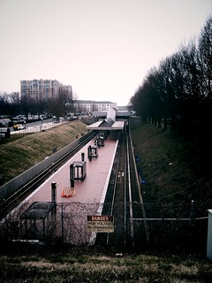
Grosvenor Metro station. Photo by Isaac Wedin on Flickr. |
Get ready for major construction along the Metrorail Red Line. Starting in the summer of 2016, WMATA will close portions of the Red Line between Friendship Heights and Grosvenor for 14 weekends, including one stretch of at least 7 consecutive weekends.
The good news is that in exchange for all those closures, Metro will complete a whole cadre of major rehabilitation projects up and down the line, and begin construction on the Purple Line. Instead of the piecemeal reconstruction that’s characterized Metro rebuilding elsewhere, this will be a comprehensive program that will solve several problems at once.
Metro will fix water leaks in the subway tunnel, repair the piers that hold up the elevated tracks near Grosvenor, rebuild the platform at Grosvenor, and begin construction on a new mezzanine at Bethesda station, for transfers to the Purple Line.
The most significant construction will happen just outside Medical Center station, where Metro workers will install a large arch between the tracks and ceiling, to help waterproof the tunnel.

Medical Center arch. Image from WMATA.
The work is necessary because water leaks in the subway tunnels have been causing electrical failures. In addition to waterproofing the area around Medical Center station, workers will power wash the tunnel, fix leaks in the tunnel, install better drain pipes, and replace tunnel lights and electrical cables.
Since the water leaks are an immediate problem that will take several weekends to fix, WMATA will take advantage of the station closures to do other work as well.
Workers will rehabilitate the elevated tracks near Grosvenor, where the metal bolts holding up the aerial structure have begun to degrade. Although the structure is not in any immediate danger of falling down, it could become a threat if Metro doesn’t fix the situation now.
At Grosvenor station itself, workers will replace the crumbling original platform tiles with the newer Takoma-style tiles the agency has been using in recent years.
Finally, Metro will begin construction on its portion of the Purple Line, at the Metro stations that will double as Purple Line transfer points. At Bethesda, workers will begin to install a second entrance and mezzanine. At Silver Spring, workers will begin to plan a similar connection, although construction won’t begin yet during this period.

Bethesda second mezzanine. Image from WMATA.
There’s no doubt all this construction will be painful for riders, but it’s better than the alternate. At one point, Metro management was considering completely closing this part of the Red Line 24×7 for at least five weeks. By closing only the weekends, at least the line will remain useful for commuters.
Correction: The initial version of this post implied that a new arch would go inside Medical Center station. It is actually in the tunnel just outside the station.
Cross-posted at Greater Greater Washington.
October 6th, 2014 | Permalink
Tags: events, metrorail, transportation
|
Media


Site
About BeyondDC
Archive 2003-06
Contact
Category Tags:
Partners
|


