|
Special Features


Image Libraries


|
|
Blog
MoveDC plan proposes more cycletracks, transit, and tolls. Will it actually happen?The latest draft of DDOT’s citywide transportation plan, moveDC, calls for a massive expansion of transit and cycling facilities throughout the District, plus new tolls on car commuters. If the District adopts it, the plan will become one of America’s most progressive.

The moveDC plan summary map. All images from DDOT.
DDOT released the latest version of moveDC last Friday, launching a month long public comment period in anticipation of a DC Council hearing on June 27. Following that, the mayor will determine any changes based on the comment period, with final adoption anticipated this summer.
What’s in the plan
Amid the hundreds of specific recommendations in the plan, three major proposed initiatives stand out:
- A vastly improved transit network, with 69 miles of streetcars, transit lanes, and improved buses, plus a new Metrorail subway downtown.
- A massive increase in new cycling infrastructure, including the densest network of cycletracks this side of Europe.
- Congestion pricing for cars entering downtown, and traveling on some of DC’s biggest highways.
Transit

Proposed high-capacity transit network (both streetcars and bus). Blue is mixed-traffic, red is dedicated transit lanes.
The plan proposes to finish DC’s 22-mile streetcar system, then implement a further 47-mile high-capacity transit network that could use a combination of streetcars or buses. That includes 25 miles of dedicated transit lanes, including the much requested 16th Street bus lane.
Although the proposed high capacity transit corridors closely mirror the 37-mile streetcar network originally charted in 2010, there are several new corridors. In addition to 16th Street, moveDC shows routes on Wisconsin Avenue, both North and South Capitol Streets, H and I Streets downtown, and several tweaks and extensions to other corridors.
The plan endorses WMATA’s idea for a new loop subway through downtown DC, but explicitly denies that DC can fund that project alone.
MoveDC also shows a network of new high-frequency local bus routes, including Connecticut Avenue, Military Road, Alabama Avenue, and MacArthur Boulevard.
Bicycles
MoveDC also includes a huge expansion of trails and bike lanes, especially cycletracks.

Proposed bike network. The pink lines are cycletracks.
Under the plan, DC would have a whopping 72 miles of cycletracks crisscrossing all over the city. From South Dakota Avenue to Arizona Avenue to Mississippi Avenue, everybody gets a cycletrack.
Meanwhile, moveDC shows major new off-street trails along Massachusetts Avenue, New York Avenue, and the Anacostia Freeway, among others.
Tolls for cars
Congestion pricing is clearly on DDOT’s mind, with multiple proposals for new variable tolls in the plan.

Proposed downtown cordon charge zone.
The most aggressive proposal is to a declare a cordon charge to enter downtown in a car. This idea has worked in London and has been discussed in New York and San Francisco, but so far no American city has tried it.
Meanwhile, some of the major car routes into DC would also be converted to managed lanes. Like Maryland’s ICC or Virginia’s Beltway HOT lanes, managed lanes have variable tolls that rise or fall based on how busy a road is.
MoveDC proposes managed lanes on I-395, I-295, New York Avenue, and Canal Road.
What will the council think?
DDOT has produced a very strong plan, but is it going anywhere? The DC Council will discuss moveDC on June 27, at which time we’ll find out if the same people who pulled the rug out from under streetcar funding are interested in progressive policy-making, at least.
Even if DC does adopt this plan, whether the council will actually provide the funds necessary to build it is anybody’s guess.
Correction: An earlier version of this story reported the DC Council will approve or deny this plan. Authority to approve it actually rests solely with the mayor.
 Cross-posted at Greater Greater Washington. Cross-posted at Greater Greater Washington.
June 2nd, 2014 | Permalink
Tags: bike, BRT, bus, government, lightrail, master planning, metrorail, roads/cars, streetcar, transportation

The DC region has over 250 miles of planned light rail, streetcar, & BRTWhat do you get when you plot onto a single map every known light rail, streetcar, and BRT plan in the DC region? One heck of a huge transit network, is what.
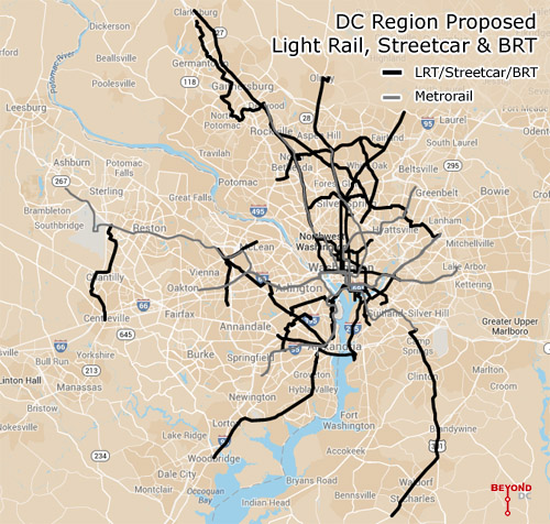
Every planned light rail, streetcar, and BRT line in the DC region. Click the map to open a zoom-able interactive version. Basemap from Google.
This map combines the DC streetcar and MoveDC bus lane plan with the Arlington streetcar plan, the Alexandria transitway plan, Montgomery’s BRT plan, and Fairfax’s transit network plan, plus the Purple Line, the Corridor Cities Transitway, the Long Bridge study, the Wilson Bridge transit corridor, and finally the Southern Maryland transit corridor.
Add the route mileage from all of them up and you get 267 miles of proposed awesomeness, not including the Silver Line or other possible Metrorail expansions.
To be sure, it will be decades before all of this is open to passengers, if ever.
The H Street Streetcar will be the first to open this year, god willing, with others like the Purple Line and Columbia Pike Streetcar hopefully coming before the end of the decade. But many of these are barely glimpses in planners’ eyes, vague lines on maps, years or decades away from even serious engineering, much less actual operation.
For example, Maryland planners have been talking about light rail extending south into Charles County since at least the late 1990s, but it’s no higher than 4th down on the state’s priority list for new transit, after the Purple Line, Corridor Cities Transitway, and Baltimore Red Line. Never mind how Montgomery’s expansive BRT network fits in.
Meanwhile in Virginia, the Gallows Road route seems to be a brand new idea. There’s yet to be even a feasibility study for it.
Even if governments in the DC region spend the next few decades building this network, there are sure to be changes between now and the day it’s all in place. Metro’s original planners didn’t know Tysons would become the behemoth it is, and contemporary planners can’t predict the future with 100% accuracy either.
Last year the Coalition for Smarter Growth published a report documenting every known route at that time, and already a lot has changed. More is sure to change over time.
Holes in the network
With a handful of exceptions these plans mostly come from individual jurisdictions. DC plans its streetcars, Montgomery County plans its BRT, and so on.
That kind of bottom-up planning is a great way to make sure land use and transit work together, but the downside is insular plans that leave gaps in the overall network.
Ideally there ought to be at least one connection between Fairfax and Montgomery, and Prince George’s ought to be as dense with lines as its neighbors.
But still, 267 miles is an awfully impressive network. Now let’s build it.
Cross-posted at Greater Greater Washington.
May 6th, 2014 | Permalink
Tags: BRT, lightrail, maps, master planning, streetcar, transportation
Fairfax’s answer to neighbors’ transit plans: Light rail, streetcars, and BRTNot to be outdone by its neighbors’ aggressive plans for rail and BRT networks, Fairfax County has an impressive transit plan of its own.
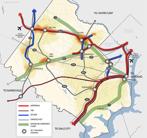
Fairfax County’s proposed high quality transit network. Image from Fairfax.
DC has its streetcar and moveDC plans, Arlington and Alexandria have streetcars and BRT, and Montgomery has its expansive BRT network, plus of course the Purple Line.
Now Fairfax has a major countrywide transit plan too, called the High Quality Transit Network.
Fairfax’s top priorities are to finish the Silver Line and the Bailey’s Crossroads portion of the Columbia Pike streetcar, but that’s not the end of their plans.
County planners are also looking at several other corridors, including Route 1, Route 7 (both east and west of Tysons), I-66, Route 28, and Gallows Road/Dolly Madison Boulevard.
Both rail and BRT are possibilities for all those corridors. Some may end up light rail or streetcar, others bus. Route 1 and I-66 could even include Metrorail extensions.
In addition to all that, Fairfax County Parkway is slated for HOT lanes, which could make express buses a more practical option there.
As the DC region continues to grow, and demand for walkable, transit-accessible communities continues to increase, these types of plans are crucial. If our major arterial highways are going to become the mixed-use main streets of tomorrow, transit on them must significantly improve.
Fairfax is undeniably still spending a lot on bigger highways. Planners’ inability to calm traffic on Routes 7 and 123 through Tysons, for example, indicates roads are still priority number one. But it takes a plan to change, and this is a strong step forward. So good on Fairfax for joining the club.
Cross-posted at Greater Greater Washington.
April 22nd, 2014 | Permalink
Tags: BRT, land use, lightrail, master planning, metrorail, roads/cars, streetcar, transportation
Elevated supertrain for 1/3 the cost of light rail? Yeah rightA startup maglev manufacturer that’s never built a functioning transit system is stirring up controversy in Virginia Beach, claiming they can build a levitating, elevated high speed maglev from Norfolk to Virginia Beach for 1/3 the cost of surface light rail.
Yeah right. And if you believe that, they can probably sell Hampton Roads a couple of bridges, too.
Unfinished maglev at Old Dominion University. Photo by withvengeance86 on flickr.
Elevated rail is more expensive than surface rail. New technologies are more expensive than proven ones, and maglev in particular (on which trains levitate above a magnetic field rather than glide on tracks) has been super expensive wherever built. And since Norfolk already has light rail, you’d be forcing a transfer unnecessarily.
Oh, and this same company tried to build a maglev at Old Dominion University in Norfolk years ago, and never finished.
This is all reminiscent of the California hyperloop proposal. They’re both completely unrealistic, almost certainly built on either faulty assumptions or outright lies, and serve no purpose but to strip support away from actually practical transit options.
I hate to be a closed minded curmudgeon. Maglev trains are cool and can work. Absent the claim that this could be done for 1/3 the cost of light rail, it might be worth exploring. But we have enough experience with other maglev proposals to know this one smells fishy.
March 4th, 2014 | Permalink
Tags: lightrail, transportation
Europe’s real streetcar lesson: Context mattersIn the ongoing debate about where and when to build streetcars, the topic of whether they should run in mixed-traffic or dedicated lanes is a major point of contention. But outside the ivory tower of the blogosphere, it’s not an ideological question so much as a contextual one.

Like many cities, Portland builds both.
Virtually all transit advocates agree that both rail and buses run better when you give them a dedicated right of way. But since real life isn’t SimCity, cities only dedicate space to transit where the geographic and political context allows.
For most cities, that means dedicated transitways sometimes, and mixed-traffic others.
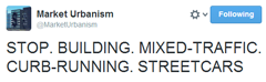
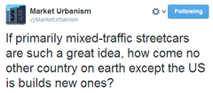
But Stephen Smith, who blogs at Next City and Market Urbanism, has made it a point to categorically attack mixed-traffic streetcars:
Smith admits that Europe does build mixed-traffic streetcars, but argues theirs usually have fewer and shorter mixed-traffic segments.
While the lines Malouff mentioned do at times travel in lanes with cars, these segments are, with one exception, very short.
That’s true. It’s because European cities are starting from a stronger transit context than most US cities. Many of them still run their original mixed-traffic trolley networks, so they don’t need to build those now. Meanwhile, with such convenient transit networks already in place, taking lanes from cars is more politically palatable.
Yet still, Stephen admits that European cities use mixed-traffic when the context is appropriate.
Of course that’s what they do. That’s what US cities do too. That’s what everyone does.
That’s why DC’s east-west streetcar runs in mixed-traffic on H Street but will have a dedicated transitway downtown, why Arlington’s streetcar runs in mixed-traffic on Columbia Pike but in a transitway in Potomac Yard, and why Seattle’s South Lake Union streetcar runs in mixed-traffic on Westlake Avenue but in a transitway on Valley Street.
Context is why Tacoma and Houston have transitway streetcars, while Tucson and Atlanta will have the exact same vehicle models running in mixed-traffic. It’s why Salt Lake City’s “light rail” sometimes runs in the street, while its “streetcar” runs in an old freight corridor. And it’s why Portland runs a mixed-traffic streetcar line and a dedicated-lane light rail one on perpendicular streets through the same intersection.
And it’s why half the cities in Europe run a combination of mixed and dedicated trams.
That isn’t an argument for or against mixed-traffic streetcars, nor for or against BRT, nor for or against anything. It’s an admission that everyone builds the best thing they can based on the circumstances of where they are, who they are, and what they’re trying to accomplish.
It’s an admission that context matters, and we all make decisions based on real world constraints and opportunities rather than black and white dogma.
Don’t use hypothetical perfects to ruin real life goods
Smith is right that every streetcar line in America that’s planned to run in mixed-traffic would be better if it had a transitway. Every one. In the places where dedicated lanes aren’t proposed, it’s totally appropriate to ask why not, and advocate for their inclusion. Transit advocates should absolutely be doing that.
But if we don’t get everything we want, we need not take our ball and go home. There are plenty of benefits to streetcars besides where they run, plenty of room for meaningful transit improvements even without a lane.
Sometimes there’s a good reason for running in mixed-traffic. Probably not as often as it actually happens, but sometimes. For example on Columbia Pike, where Arlington is prohibited from taking lanes.
Even if the only reason is political, as it seems to be in Cincinnati, some places face such a monumental uphill battle to get anything transit-related done, even a single mixed-traffic streetcar can raise regional transit ridership by almost 10%. That’s a huge victory in a place where holding out for something perfect would likely kill the project completely.
What transit advocates shouldn’t be doing is falsely claiming that nobody except misguided Americans builds streetcars. It’s not true and it’s not helpful. Broad brush attacks lead others to pen bogus anti-rail screeds with misleading information.
So by all means, let’s do more to fight for transitways. But in our attempts to do so, let’s not tear down the places that for whatever reason are merely capable of making good investments instead of perfect ones.
For the record, the same argument is true for BRT. Sometimes it’s the right answer, even though BRT creep, where costly transit features are stripped away to save money, is often a problem.
Cross-posted at Greater Greater Washington.
January 29th, 2014 | Permalink
Tags: lightrail, streetcar, transportation
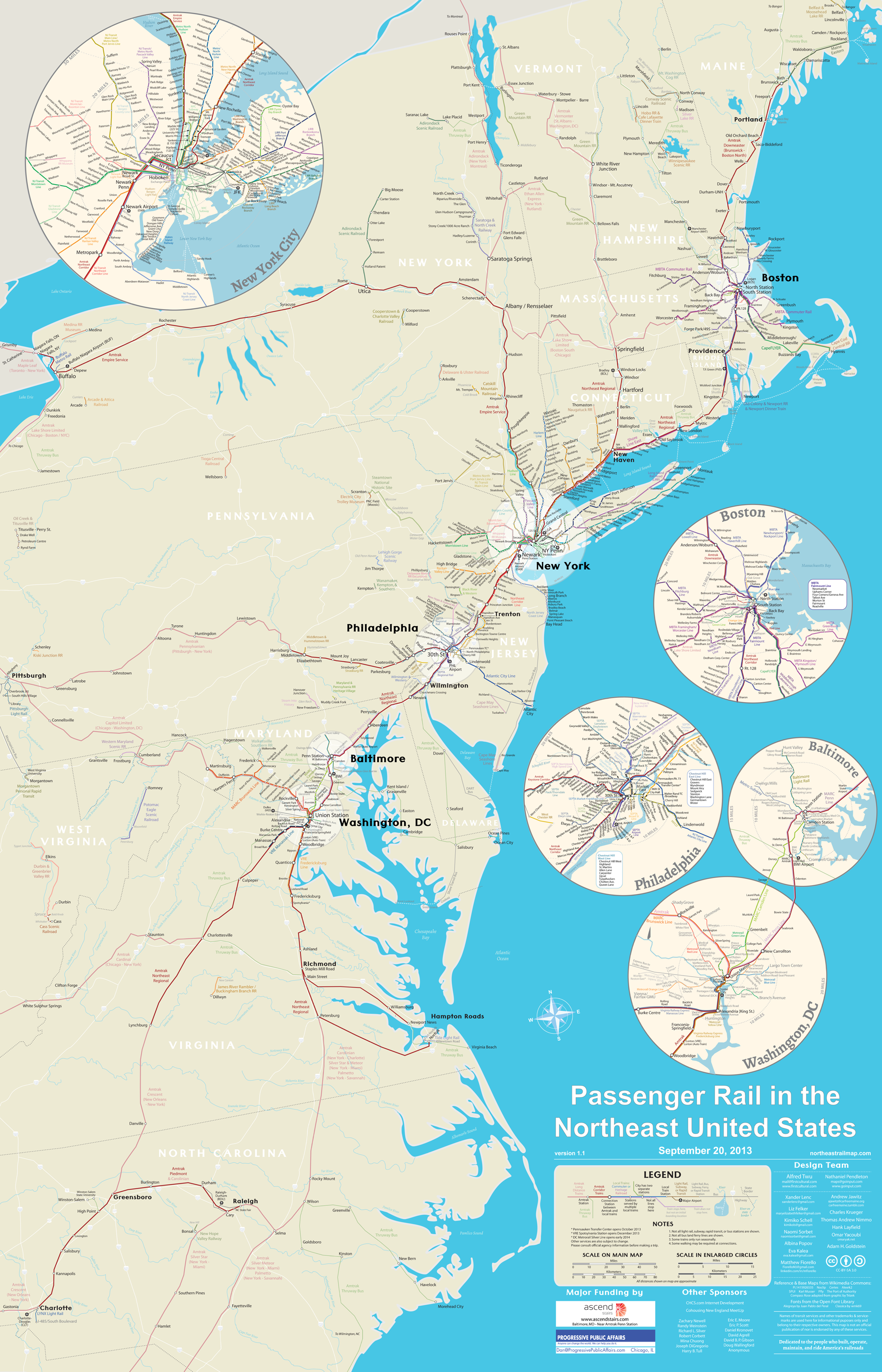
All northeast US passenger rail on one awesome mapThis map shows every Amtrak, commuter rail, metro, light rail, and tourist rail line from Maine to North Carolina, to scale.
It comes from NortheastRailMap.com, and you can even download it in a fully-editable Adobe Illustrator format.
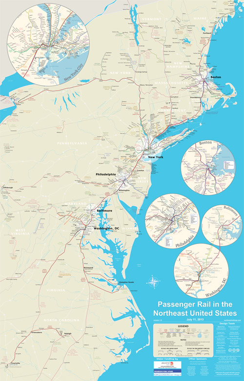
Image from NortheastRailMap.com.
Update: The map’s author has requested that you “like” their page on Facebook. Please help them out and do that!
Cross-posted at Greater Greater Washington.
November 5th, 2013 | Permalink
Tags: commuterrail, intercity, lightrail, maps, metrorail, streetcar, transportation
Notes from Seattle: The subwayI’m in Seattle this week for the Railvolution conference, along with about half of GGW’s editorial team. Since I’ll be too busy geeking out at transit nerd nirvana to blog, each day this week there will be a brief post about some cool transportation-related thing here in Seattle. Today: Their unique bus/rail subway.
The Seattle Transit Tunnel is a 5-station subway that forms the core of Seattle’s transit network. It started off as a bus-only subway, but became a joint bus/rail tunnel when Seattle’s Central Link light rail line opened in 2009.
Each station is different, but one, Pioneer Square, would look particularly at home in DC:
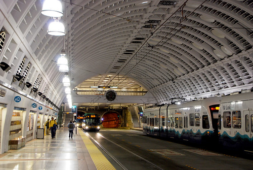
Pioneer Square subway station.
Tomorrow: The famous Monorail.
Cross-posted at Greater Greater Washington.
October 21st, 2013 | Permalink
Tags: BRT, bus, lightrail, transportation
Montgomery rethinks Bethesda Purple Line stationThe Bethesda Purple Line station is currently planned to squeeze into an existing tunnel below Bethesda’s Apex Building. But planners are now considering an alternate plan to tear down the Apex Building and redevelop the entire site.
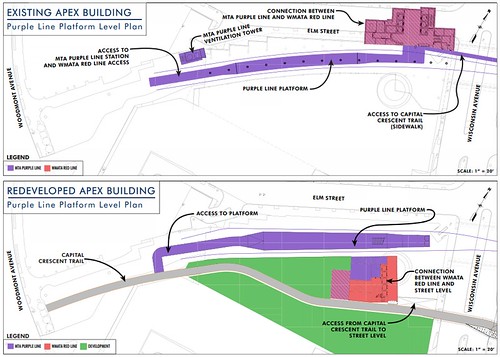
Existing plan (top) and alternate proposal (bottom). Images by Maryland MTA.
Between Silver Spring and Bethesda the Purple Line will run on land from a former railroad line. Years ago the railroad sold the development rights above the tracks in downtown Bethesda. Now there are two buildings atop the rail corridor, the Apex Building and the Air Rights Building.
The Purple Line will pass easily under the Air Rights Building, but the Apex Building needs to accommodate a station. And while the tunnel there was designed to carry tracks, it wasn’t originally built to hold a station. The structural columns supporting the building come down into the rail tunnel, severely constraining the space.
Planners can squeeze a station in the existing space, but the result is a narrow platform crowded with building columns.
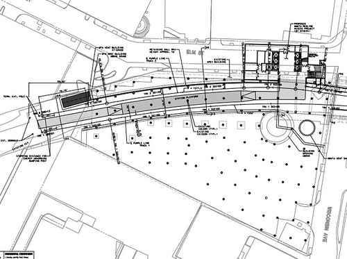
Apex Building column layout. Image by Maryland MTA.
Meanwhile, there are other problems with the existing arrangement. There’s not enough room in the tunnel for both a light rail station and a bike trail, so the trail is planned to be moved to the surface.
Also, building a subway station under the Apex Building would complicate any potential future redevelopment prospects. Since the Apex Building is only 5 stories tall, it’s already shorter than most other buildings nearby, and it will become a prime redevelopment candidate after Bethesda becomes a key Purple Line / Red Line transfer point.
Redeveloping now could solve the problem
The new proposal suggests tearing down the Apex Building, building the Purple Line station in a new custom-built trench, adding a 2nd tunnel for the trail, and then allowing the owners of the Apex Building to replace it with a bigger building.
Montgomery County is currently in talks with the owner of the building, and is working through a minor master plan amendment to determine the density and height.
If the new plan is approved, all the pieces will work together better. The Purple Line station will be simpler and more spacious, bike riders will have an uninterrupted dedicated trail, and one of the most transit-accessible properties in Montgomery County can be redeveloped at a more appropriate density.
It would be win/win/win.
As long as this doesn’t delay the rest of the Purple Line, I say let’s do it.
Cross-posted at Greater Greater Washington.
September 10th, 2013 | Permalink
Tags: development, lightrail, master planning, transportation, urbandesign
Denver proves Purple Line private funding can work
|
Denver is expanding its light rail system using private partners. |
Maryland Governor O’Malley is expected to announce today that the federal government has approved the Purple Line’s planning, and that Maryland will seek a private company to help pay for construction.
The idea is that a private company would pool its money together with state and federal funding to construct the Purple Line. The same company would then operate the line. In exchange, they would keep the fares, and Maryland would pay an annual contract fee.
With limited federal funds available, this type of public-private partnership is becoming common nationwide. DC is considering it for streetcars, but Denver offers a more instructive example.
In 2004, voters in Colorado passed a referendum for 122 miles of new rail transit in the Denver area. But the funding approved as part of that vote wasn’t adequate to build everything, so the transit agency had to find an alternate strategy. They’ve since approved two public-private partnerships, and are in the process of contracting a third.
Denver’s first partnership was for the Eagle P3 project, which is building 40 miles of electric commuter rail to the Denver suburbs and airport, at a cost of about $2 billion. The partnership is proceeding smoothly, with construction well underway and completion expected in 2016.
The second partnership is for a 10-mile-long suburban light rail extension. It began construction last year and is also expected to open in 2016.
The third will be for the 18-mile North commuter line. The transit agency put out a Request For Proposals in June, and is expected to select a partner company this fall.
All in all, Denver has or will soon have private partnerships to build almost 70 miles of new rail.
These deals do come with a cost. Typically the annual fee the state has to pay the partner is higher than the typical operating subsidy would be. So in essence, the operating cost is higher. But in exchange, the partner builds the line more quickly and sometimes more cheaply than the government could on its own.
Update: As expected, O’Malley announced the plan to use a partnership this afternoon. He also announced $680 million in state funds for the Purple Line, plus millions more for the Corridor Cities Transitway, Montgomery County Ride-On, and road projects.
August 5th, 2013 | Permalink
Tags: commuterrail, funding, government, lightrail, transportation
Northern Virginia picks transportation projects to fund
|
Almost $20 million will go to new VRE railcars. |
For years, leaders in Northern Virginia have been asking Richmond to let Northern Virginia raise its own money to spend on its own transportation priorities. They are finally getting the chance.
When the Virginia General Assembly passed a broad new transportation funding bill earlier this year, it included a section for Northern Virginia to raise and allocate hundreds of millions of dollars per year. Those new taxes began rolling in on July 1, with the beginning of Virginia fiscal year 2014.
On Wednesday night, the Northern Virginia Transportation Authority (NVTA) officially approved its first set of projects. The authority allocated about $210 million, split roughly evenly between transit and roads.
The largest projects include the Silver Line’s Innovation Center Metro station, new VRE railcars, and widenings along Route 28.
NVTA also approved a bond validation lawsuit that will preemptively ask Virginia courts to rule on NVTA’s legality. That process should take 6-9 months, and NVTA will have to wait until it’s over to actually start spending money. Taking the suit to court now means NVTA won’t have to spend years fending off other legal challenges.
The project list is shown below. For more details, see the project description sheets on NVTA’s website.
| Project |
Funding
in millions |
Location |
| Transit and multimodal projects |
| Innovation Center Metro station |
$41 |
Fairfax Co. |
| VRE railcars |
$19.8 |
Regional |
| VRE Lorton station 2nd platform |
$7.9 |
Fairfax Co. |
| WMATA buses |
$7 |
Regional |
| WMATA Orange Line traction power upgrades for 8-car trains |
$5 |
Regional |
| DASH buses |
$3.3 |
Alexandria |
| Potomac Yard Metro station environmental study |
$2 |
Alexandria |
| Crystal City multimodal center bus bays |
$1.5 |
Arlington |
| VRE Gainesville extension planning |
$1.5 |
Regional |
| VRE Alexandria station pedestrian tunnel & platform improvements |
$1.3 |
Alexandria |
| Herndon Metro station access improvements (road, bus, bike/ped) |
$1.1 |
Fairfax Co. |
| ART buses |
$1 |
Arlington |
| Leesburg park and ride |
$1 |
Loudoun |
| Loudoun County Transit buses |
$0.9 |
Loudoun |
| Route 7 Tysons-to-Alexandria transit alternatives analysis (phase 2) |
$0.8 |
Regional |
| Falls Church pedestrian access to transit |
$0.7 |
Falls Church |
| Duke Street transit signal priority |
$0.7 |
Alexandria |
| PRTC bus |
$0.6 |
Prince William |
| Alexandria bus shelters & real-time information |
$0.5 |
Alexandria |
| Van Buren pedestrian bridge |
$0.3 |
Falls Church |
| Falls Church bus shelters |
$0.2 |
Falls Church |
| Road projects |
| Rt 28 – Linton Hall to Fitzwater Dr |
$28 |
Prince William |
| Rt 28 – Dulles to Rt 50 |
$20 |
Fairfax Co. |
| Belmont Ridge Road north of Dulles Greenway |
$20 |
Loudoun |
| Columbia Pike multimodal improvements (roadway, sidewalk, utilities) |
$12 |
Arlington |
| Rt 28 – McLearen to Dulles |
$11.1 |
Fairfax Co. |
| Rt 28 – Loudoun “hot spots” |
$6.4 |
Loudoun |
| Chain Bridge Road widening |
$5 |
Fairfax City |
| Boundary Channel Dr interchange |
$4.3 |
Arlington |
| Rt 1 – Featherstone Rd to Mary’s Way |
$3 |
Prince William |
| Edwards Ferry Rd interchange |
$1 |
Loudoun |
| Herndon Parkway intersection with Van Buren St |
$0.5 |
Fairfax Co. |
| Herndon Parkway intersection with Sterling Rd |
$0.5 |
Fairfax Co. |
Cross-posted at Greater Greater Washington.
July 26th, 2013 | Permalink
Tags: BRT, bus, commuterrail, funding, government, lightrail, metrorail, roads/cars, transportation
|
Media


Site
About BeyondDC
Archive 2003-06
Contact
Category Tags:
Partners
|