|
Special Features


Image Libraries


|
|
Blog
90 new rowhouses at a Michigan Park seminary could help address the housing shortageThe St. Joseph’s Seminary in Northeast DCs’s Michigan Park neighborhood has a large eight-acre property, but the seminary only uses two acres. Rather than let the rest sit empty, they plan to add 90 new rowhouses on four acres, and turn the rest into a park.

The historic seminary building, as seen from 13th Street NE. Photo by Jonathan Neeley.
The Josephites, as the seminarians call themselves, have been working with developer EYA to build on the site. EYA’s proposal is called 12th and Allison. It focuses on the northern part of the site, preserving the southern part and its historic seminary building.

Location of St. Joseph’s Seminary. Image from EYA.
The Josephites would retain ownership of the southern part of the property, which includes both the building itself as well as a little over two acres of open space.
To the north, EYA would extend Webster Street through the block, connecting to 12th Street (Webster currently ends when it hits 13th, on the east side of the property). Surrounding the new Webster Street would be 90 rowhouses, most of them north of the new street.
Triplexes everywhere versus rowhouses and a park
Today the seminary grounds look sort of like a park. But they’re not. The seminary is private property, and if the Josephites sell part or all of it, that part can be developed according to however it’s zoned.
Almost all of Michigan Park is zoned R-2, which allows “semi-detached” housing like duplexes and triplexes. Many of the blocks surrounding the seminary are lined with the latter.
But developers rarely build triplexes these days. They require so many setbacks that it doesn’t pencil out to add in any communal open spaces like parks. But the setbacks are rarely large enough to be very good private yards. For new construction in the city, regular rowhouses are more popular with both sellers and buyers.
Thus, EYA hopes to rezone the property to R-5A, the same as Providence Hospital across the street. R-5A zoning would allow for normal rowhouses, which in turn could be clustered together, allowing for better community open spaces.
But rezoning requires city action, and that opens the door to controversy.
At a community meeting in October of last year, a number of residents made it clear that they were opposed to development of any kind. At least twice throughout the winter, opponents spread these flyers throughout the neighborhood, forewarning against the evils of building:

Opponent flyer. Photo by Jonathan Neeley.
Michigan Park is a cozy, moderate-density neighborhood. It’s fair for residents to wonder about the impact of a new development, and hope to influence it. But hyperbole like that isn’t helpful and isn’t true. Saying this project would “irrevocably damage our community” is a stretch.
90 new units on two big blocks won’t turn the place on its head. That’s only a little denser in total than the surrounding blocks of duplexes and triplexes.
By clustering the development mostly north of Webster Street and preserving more open space south of it, the northern block will be noticeably denser than triplexes, but in return the historic seminary building and much of the open space on the south will be permanently preserved, designated historic, and off-limits to future development.
That’s a good trade. Right now, if the Josephites wanted, they could sell their entire property and develop 100% of it as duplexes and triplexes by-right, whether anybody objected or not. Rather, in exchange for rezoning to allow rowhouses, the seminary and considerable open space will be saved.
Next steps
In April, EYA will present its latest plans at local ANC meetings. They’ve reduced the density of the proposal from 180 houses to 90, and promised to design the buildings in a high-quality, contextual way.
After that, they’ll submit for zoning approval, and apply to the District’s Historic Preservation Review Board to designate the seminary building as a landmark. Expect hearings on it this fall.
 Comment on this at the version cross-posted to Greater Greater Washington. Comment on this at the version cross-posted to Greater Greater Washington.
April 13th, 2016 | Permalink
Tags: development, land use, master planning, preservation

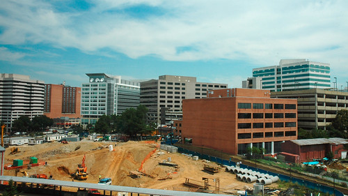
H Street’s sprawling Hechinger Mall is a sleeping giant, waiting to boomThe redevelopment boom on H Street NE hasn’t yet transformed Hechinger Mall, the big suburban-style strip mall where H Street meets Bladensburg Road and Benning Road. But someday, when it inevitably does, there’s enough land for an entire neighborhood.
By superimposing a map of the Hechinger Mall area on top of other parts of DC, one can see just how great a change is on the horizon.

Hechninger Mall and surrounds by Dan Malouff using Mapfrappe and Google.
In the above image, the blue line outlines Hechinger Mall plus several surrounding properties with similar car-oriented retail. The mall and its surrounds beat as the commercial heart of multiple Northeast neighborhoods, including Trinidad, Carver-Langston, and Kingman Park.
It’s not unused land; there are plenty of stores, and they do robust business. But it’s definitely underused. Vast acres of parking sit mostly empty. Single suburban-style stores take up entire blocks. Internal streets look like highways, despite low traffic.
Someday it is going to redevelop. When that happens, it’s going to be as much a big deal as redevelopment in Columbia Heights or Union Market.
Compare the land
Let’s compare the amount of land we’re talking about.
Using a neat tool from Mapfrappe, it’s possible to superimpose that blue Hechinger Mall outline on top of other parts of DC, at the same scale.
Here’s Columbia Heights:

Columbia Heights comparison by Dan Malouff using Mapfrappe and Google.
As you can see, the blue Hechinger Mall outline is almost exactly the same size and shape of the center of Columbia Heights. You could almost pick up 14th Street and plop it down at Hechinger, and it would fit.
Now Union Market:

Union Market comparison by Dan Malouff using Mapfrappe and Google.
Again, it’s almost exactly the same size as the entire Union Market neighborhood.
Let’s keep going. NoMa next:

NoMa comparison by Dan Malouff using Mapfrappe and Google.
And now, City Center DC:

City Center comparison by Dan Malouff using Mapfrappe and Google.
NoMa is bigger. But Hechinger Mall is about the same size as the others. That’s the scale of redevelopment that could—that probably will—come to H Street.
And that’s great. There’s nothing wrong with the stores at Hechinger; DC needs shops like Safeway, Ross, and Dollar Tree. But DC also needs places to put more housing, and football field-sized parking lots a mile-and-a-half from the Capitol are exactly the right place.
Comment on this at the version cross-posted to Greater Greater Washington.
December 1st, 2015 | Permalink
Tags: land use, master planning
Norfolk’s light rail decision: Embrace the city, or follow the highwayAs Norfolk plans the next expansion of its burgeoning light rail system, a classic transit dilemma faces the community: Will the northern extension to Naval Station Norfolk run through rider-rich urban neighborhoods, or take the path of least resistance along wide suburban highways?
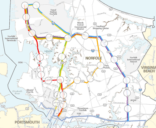
Potential light rail routes. Image from HRT.
Hampton Roads Transit is planning two light rail extensions. One, east to Virginia Beach, is relatively straightforward; it will follow an old rail right-of-way. The other, north to Naval Station Norfolk, is a challenge.
The northern extension will have to run on or adjacent to streets, and could follow any one of several alignments planners are currently considering.
If the light rail follows Granby Street, a tightly packed urban commercial street, or Hampton Boulevard, the main street through Old Dominion University, then it will probably capture a lot of local riders, since those are walkable transit-friendly destinations. On the other hand, adding transit lanes would be more disruptive for car drivers on narrow streets than on wider, more suburban highways, since there’s less space to go around.
Conversely, if the light rail follows the more easterly Military Highway, there will be plenty of space to accommodate trains without disrupting cars, and commuters to the navy base using park-and-rides near the end of the line will have a quick ride from their cars to the base.
But that alignment wouldn’t serve any strongly walkable neighborhoods; it would even miss downtown Norfolk. It would offer quick rides to one destination and easy construction, but the resulting line would be a glorified parking shuttle to the navy base, not the spine of a transit-oriented community.
Maybe after a few decades a Military Road alignment might induce enough transit oriented development that some of its stations could become walkable. Or maybe not. In the meantime, Norfolk’s genuinely urban neighborhoods will still need better transit.
Meanwhile, the Church Street alignment would split the difference by skirting the outer edge of downtown Norfolk, and the Chesapeake Boulevard alignment would snake along an indirect route that serves a few additional neighborhoods, but would be very slow from end to end. These options look like compromises unlikely to satisfy anybody.
Planners have already dropped the most urban alignment options, which would have gone through Norfolk’s dense Ghent neigborhood. Not only does that mean the most walkable part of Norfolk besides downtown will be without rail, but also that the western end of the existing light rail line will be a spur, forcing transfers.
Experience says pick the urban options
The fast and easy suburban options are tempting. Not only are they the path of least resistance, but computer models of traffic behavior probably predict that the more suburban routes capture the most navy base commuters.
But history shows light rail systems built like that don’t work very well. Computer models are good at predicting long distance car commutes, but bad at understanding travel in walkable areas. They naturally push planners towards park-and-ride oriented systems, when we know the most successful transit routes follow dense walkable corridors instead.
So Norfolk faces a choice: Embrace the city and build a transit line for the city, or follow a highway and build a park-and-ride shuttle.
Cross-posted at Greater Greater Washington.
October 21st, 2014 | Permalink
Tags: land use, lightrail, transportation
More households near transit mean more transit riders
Pop quiz: Can you name the 5 Metro stations that have the highest number of households within a half-mile walk? Here’s a hint: More riders walk to those 5 stations each morning than to just about any others in the system.
It’s not a coincidence. According to WMATA’s PlanItMetro blog, “the more people can walk to transit, the more people do walk to transit — and data across Metrorail stations prove it.”
But there’s at least one surprise: 3 of the 5 stations with the most households nearby are in Maryland or Virginia, not the District.
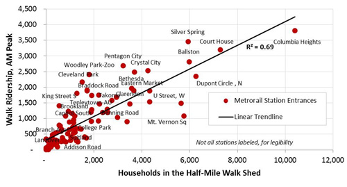
Households and walk ridership per Metro station. Image by WMATA.
Columbia Heights has by far the most households within walking distance. That makes sense. It’s one of DC’s densest neighborhoods, and the Metro station is right near its center.
But the number two most household-rich Metro station is Arlington’s Court House. Others in the top 5 are Ballston, Silver Spring, and Dupont Circle.
All 5 are among the 10 stations with the most riders who walk to the station each morning. The rest of the top 10 walking stations are Woodley Park, Cleveland Park, Pentagon City, Crystal City, and Bethesda.
More riders may be walking to jobs from the downtown stations, or from Rosslyn, but those are the destinations, where riders in the morning are getting off. The origin stations are the more residential ones.
All in all, Metro’s stations fit neatly along a trendline that shows a strong correlation between more households nearby and more riders arriving to stations by foot.
Even the outliers tell a story. U Street and Mount Vernon Square have the 6th and 7th highest number of households nearby, but they under perform on walking Metro ridership. One might speculate that Mount Vernon Square is so close to so many offices that more people simply walk. U Street is a little farther away, but it’s still close enough to downtown that buses and bicycles may be better options for a large portion of riders.
What else pops out as interesting?
Cross-posted at Greater Greater Washington.
August 13th, 2014 | Permalink
Tags: demographics, land use, metrorail, transportation
VRE infill station launches a new idea: transit-oriented sprawlVirginia Railway Express officials broke ground yesterday on the Potomac Shores station, an infill commuter rail station in Prince William County that will be the centerpiece of a new town center.
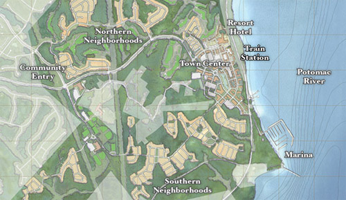
Potomac Shores site plan. Image from SunCal.
Potomac Shores is a gigantic development along Prince William’s Potomac riverfront, between Rippon and Quantico. It covers nearly 2,000 acres and will eventually have over 3,800 residential units.
The website boasts of “rugged beauty,” an on-site 18-hole golf course, and miles of recreational trails. There’s no doubt that Potomac Shores is sprawl.
But it’s a new kind of sprawl. At its center, a new urbanist town center complete with a new commuter rail station.
Developer SunCal is building the station. When it opens in 2017, and if the town center has enough amenities, Potomac Shores could legitimately be a lot less car-dependent than the typical outer suburban subdivision.
That’s great news, even if it’s still true that Potomac Shores won’t be as urban, diverse, or dense as DC.
New urbanism marries TOD
For decades now, new urbanist communities have used mixed-use and good design to make for better suburbs. Nobody would call Kentlands a true city, for example, but it’s a marked improvement over most of west Gaithersburg. And since we’ll never fit all the growth in the entire metropolitan region into DC, getting suburbs right is hugely important.
By building around a VRE station, Potomac Shores takes 20th Century new urbanism to the next level. It’s not just a traditional neighborhood development; it’s a transit-oriented development.
There are other transit-oriented new urbanist communities popping up around the region. But they’re mostly in closer-in places like Montgomery County or Fairfax, and nobody has ever built a new VRE station as the centerpiece of one.
Potomac Shores is an experiment. It’s obviously sprawl, but maybe it’ll prove to be a more sustainable and livable kind of sprawl. Time will tell.
Cross-posted at Greater Greater Washington.
August 5th, 2014 | Permalink
Tags: commuterrail, development, land use, master planning, transportation
Fairfax’s answer to neighbors’ transit plans: Light rail, streetcars, and BRTNot to be outdone by its neighbors’ aggressive plans for rail and BRT networks, Fairfax County has an impressive transit plan of its own.
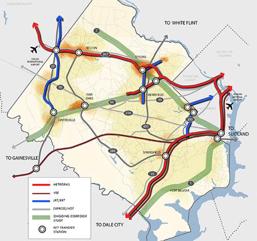
Fairfax County’s proposed high quality transit network. Image from Fairfax.
DC has its streetcar and moveDC plans, Arlington and Alexandria have streetcars and BRT, and Montgomery has its expansive BRT network, plus of course the Purple Line.
Now Fairfax has a major countrywide transit plan too, called the High Quality Transit Network.
Fairfax’s top priorities are to finish the Silver Line and the Bailey’s Crossroads portion of the Columbia Pike streetcar, but that’s not the end of their plans.
County planners are also looking at several other corridors, including Route 1, Route 7 (both east and west of Tysons), I-66, Route 28, and Gallows Road/Dolly Madison Boulevard.
Both rail and BRT are possibilities for all those corridors. Some may end up light rail or streetcar, others bus. Route 1 and I-66 could even include Metrorail extensions.
In addition to all that, Fairfax County Parkway is slated for HOT lanes, which could make express buses a more practical option there.
As the DC region continues to grow, and demand for walkable, transit-accessible communities continues to increase, these types of plans are crucial. If our major arterial highways are going to become the mixed-use main streets of tomorrow, transit on them must significantly improve.
Fairfax is undeniably still spending a lot on bigger highways. Planners’ inability to calm traffic on Routes 7 and 123 through Tysons, for example, indicates roads are still priority number one. But it takes a plan to change, and this is a strong step forward. So good on Fairfax for joining the club.
Cross-posted at Greater Greater Washington.
April 22nd, 2014 | Permalink
Tags: BRT, land use, lightrail, master planning, metrorail, roads/cars, streetcar, transportation
Another way to see the US: Map of where nobody livesThere are more than 300 million people living in the United States today, but America is such a huge country that we still have staggeringly vast areas that are completely devoid of humans. This map illustrates those places. Everything colored green is a census block with zero population.

Map by Nik Freeman of mapsbynik.com.
The eastern US is pretty well populated except for a few spots in mountains and swamps. But the west is a different story. It’s covered with enormous stretches of land that are simply empty.
And Alaska’s emptiness makes even the western contiguous states look densely populated. Those green areas near the Arctic Circle look bigger than most other states.

Map by Nik Freeman of mapsbynik.com.
Cross-posted at Greater Greater Washington.
April 16th, 2014 | Permalink
Tags: demographics, land use, maps
Why grids are better for walking, in 1 simple graphicThis graphic shows how much ground a pedestrian can cover walking along street sidewalks in a gridded Seattle neighborhood, versus a nearby suburb. Although both maps show a one-mile radius, there are far more destinations within that radius in the gridded neighborhood.
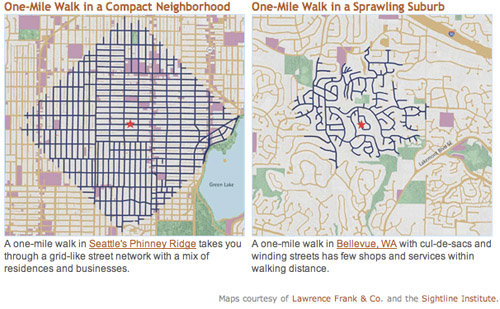
Seattle and Bellevue maps from sightline.org.
Both maps show neighborhoods that are primarily single-family detached houses: Greenwood, Seattle and Eastgate, Bellevue. But the similarities end there.
In Bellevue trips are indirect and circuitous. Not only are far more residential streets accessible in Seattle, but also more commercial streets (in purple on the map). Both neighborhoods have plenty of parks (shown in green).
Granted, the two maps appear to be at slightly different visual scales, population density is probably higher in Seattle, and pedestrians in Bellevue can probably cut through yards to get places a little faster. But the overall point remains true that far more destinations are within easy walking in Seattle, which – surprise – is why more people walk there.
For the record, the key isn’t a strict rectilinear grid; it’s interconnectivity. Boston’s medieval web of streets is just as good, and maybe even better. The real key variable is the density of intersections, not the straightness of streets.
February 28th, 2014 | Permalink
Tags: land use, maps, pedestrians, transportation, urbandesign
Silver Spring Transit Center is a terrible place for a park
|
Don’t build a park here. Photo by obz3rv3r on flickr. |
Dan Reed has a strong post up today on GGW reporting a proposal to build a park next to the Silver Spring Transit Center, and arguing why that’s a terrible idea.
Other Dan is completely right. Just to throw my support behind his sensible arguments:
- It’s not a pleasant place to be. Good urban parks need active streetscapes around them, with plenty of retail. The old Silver Spring turf worked well because it was at a location people wanted to hang out in. The transit center location on other other hand is surrounded by a parking garage, huge landscaped setbacks, blank walls, and loud, high-traffic highways next to which nobody wants to spend time. The edge conditions are awful. If you just built a park there the result would not be Dupont Circle. It would be this – dreary and dangerous.
- There are already parks directly across the street in two directions. One north at 2nd and Colesville, and the other east on the Wayne Avenue side of the Discovery Building. Granted the Discovery park is privately owned and is often fenced off, but getting Discovery to open it up more would be a vastly better and cheaper outcome than taking land next to the transit center. In any event, the other one is open all the time.
- Developing the site would actually produce a better park. Since parks should be in pleasant and active locations, good ones should be lined with pleasant buildings. The only way to line this site with pleasant buildings is to construct some pleasant buildings, and put a square in the middle. That’s a fine idea. Incidentally, that’s already the plan.
- A park would increase car traffic. Yes, it’s true. The best way to decrease car traffic is to put as much development as close to major transit stations as possible. Displacing the planned development adjacent to the transit center with a park would mean that development happens somewhere else, almost certainly somewhere less transit accessible and by extension more car-dependent.
Buying this valuable land and turning it into a park has absolutely no upside. It would be expensive and it would be a bad park and it would screw over the transportation network. Please, Montgomery County, waste no more time on this terrible, terrible idea.
PS: At Rebuilding Place in the Urban Space, Richard Layman has an extensive discussion of Silver Spring park issues.
February 19th, 2014 | Permalink
Tags: land use, parks, urbandesign
Know what you’re watching: Map of Sochi’s Olympic VillageSochi’s main Olympic Village is 20 miles southeast from downtown Sochi, near the city’s airport. It’s home to the athlete residences, stadiums for the indoor sports, a theme park, and a huge rail station. The venues for mountain sports are 35 miles inland, near Krasnaya Polyana.
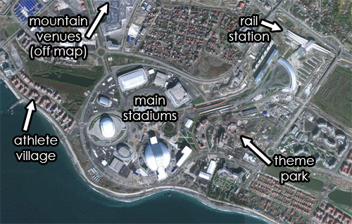
Satellite view of Sochi’s Olympic Village. Original image from Google.
February 10th, 2014 | Permalink
Tags: land use, maps, parks
|
Media


Site
About BeyondDC
Archive 2003-06
Contact
Category Tags:
Partners
|


