The secret park by the White House could be great, if people knew about it
Pershing Park is one of DC’s most unique and potentially pleasant public spaces. Unfortunately, few people have ever enjoyed it, because the park’s best elements are hidden from view behind an uninviting raised embankment.
Pershing Park as seen from Pennsylvania Avenue. Photo by Google.
It’s nice on the inside
I like Pershing Park, at Pennsylvania and 15th Street NW. I wish it worked better.
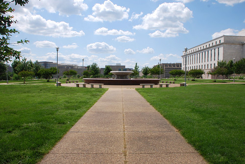
The inside of the park is a terraced wetland garden that, when it’s in good condition, is absolutely lovely.
The pleasant interior. Photo by pcouture on Flickr.
There are ample shady seats, a duck pond to dip your feet in, and climbable concrete terraces that make the park feel like an adult-size jungle gym.
It’s fun, and pretty, and unlike anything else in DC.
Or at least, it was fun and pretty a few years ago. The park has fallen into disrepair lately. The pond is dry. Orange cones litter the open plaza. It’s abandoned and depressing.
Part of Pershing Park’s problems are simply neglect. Better maintenance could fix the pond and the concrete.
But there’s one big problem, and it may well be unfixable.
People can’t see it
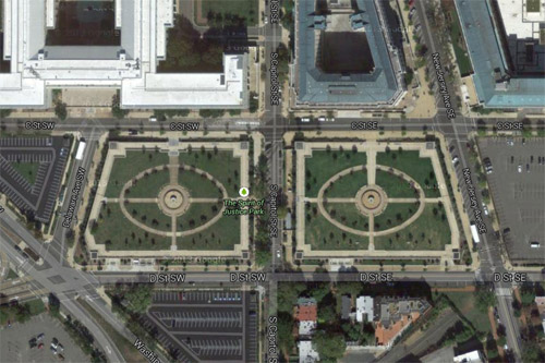
Most people don’t know the park is there. You can’t see it from the street. From three sides, the only thing visible is a grassy embankment straight out of a suburban McDonalds parking lot. The fourth side is literally a parking lot.
Pershing Park from above. Image from Google.
Good urban parks draw pedestrians in from the surrounding sidewalk. When you’re standing outside Dupont Circle, you can see and hear interesting things happening inside the park there. The activity and people inside Dupont make you want to enter it yourself.
Pershing Park is the absolute opposite. It’s plain and boring from the sidewalk. There are interesting things there, but you can’t see them so they don’t draw you in.
Most people just ignore it; the park blends into the background and they don’t give it a second thought.
Those who do look closely see a bunker, a hostile sloping hill with few entry points. From busy Pennsylvania Avenue, Pershing Park more closely resembles an 18th Century military stockade than an inviting civic space.
Until that problem is solved, Pershing will never be a good park, no matter how pleasant it is on the inside. Until that’s solved, Pershing will always be an afterthought.
Let’s fix it
What to do with Pershing Park is increasingly becoming a hot-button issue. One group wants to redevelop it as a national World War I memorial. Kriston Capps at CityLab takes a preservationist bent and says we should restore it.
Either way, the park is falling apart and needs work.
Would it be possible to save the pleasant interior and radically change the bunker exterior? Maybe, maybe not. The park occupies sloping terrain that any design will have to work around. Unfortunately, there’s no way to avoid a retaining wall somewhere. At least not if we want to keep the terraces.
But retaining walls don’t have to be so plain or uninviting. There are betterexamples elsewhere in the city.
It would be a shame to lose such a unique space. If designers can find a way to restore Pershing Park’s terraces and pond while altering the park’s exterior to be more inviting, that would be an ideal solution.
But if not, tear the sucker out. A downtown park that nobody uses isn’t a useful downtown park.
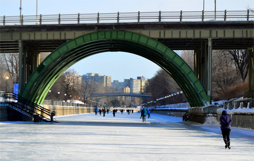
Ottawans probably don’t get a lot of snow days off work. Not with winter commuting options like the Rideau skateway, a four mile long highway for ice skaters
Rideau skateway. Photo by Ted Court on Flickr.
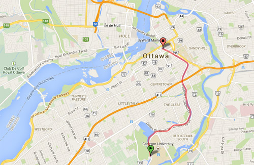
The skateway runs along the Rideau Canal, from downtown Ottawa to the south, cutting through some of Ottawa’s densest urban neighborhoods.
Rideau skateway. Basemap from Google.
During most of the year, Rideau Canal is liquid. It’s an actual, functioning canal. But in the winter it naturally freezes over, so Ottawans take advantage.
For the most part the skateway is recreational. Crowds of teenagers and happy couples play there, and advertisers bill it as the “world’s longest ice skating rink,” not as a commuter route.
But at least one person commutes on it, and that’s such a cool idea that there are surely many others.
It’s almost enough to make you wish DC winters got a bit colder.
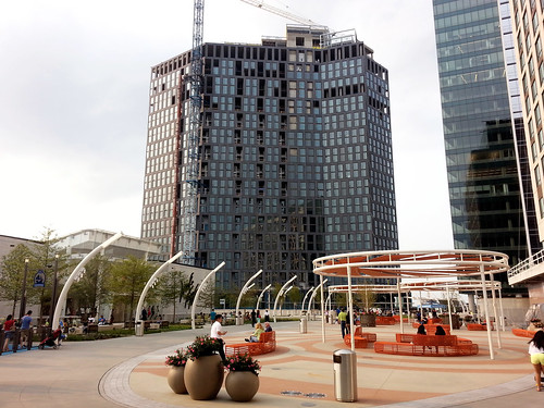
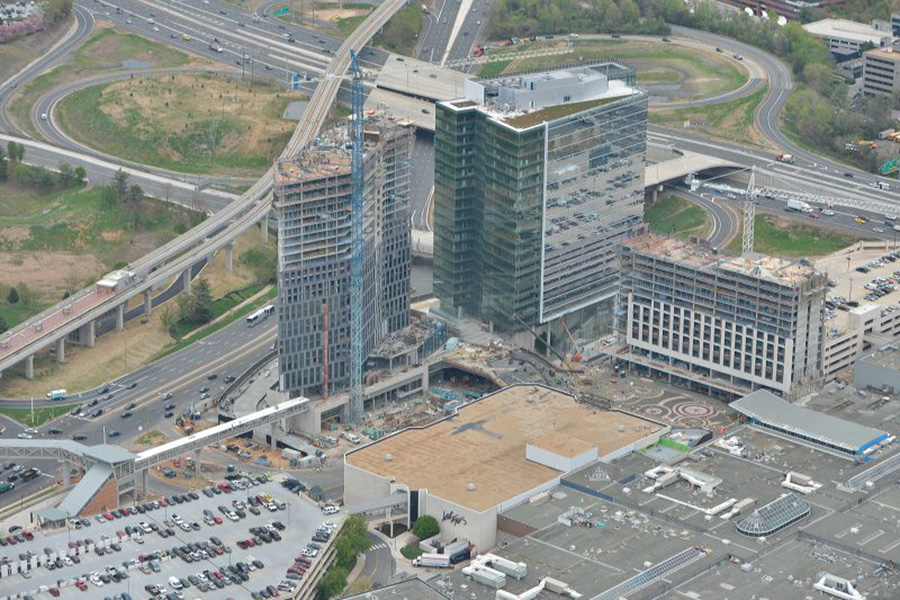
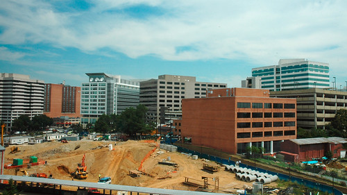
Metro’s Silver Line isn’t the only indication the transformation of Tysons Corner is clearly underway. Further undeniable evidence: The Plaza, a popular new urban-style open space at the front door to Tysons Corner Center mall.
The Plaza (that’s its official name) is on the north side of the mall, near the pedestrian bridge from the Tysons Corner Metro station. Three new high-rises are under construction around the plaza, tightly enclosing the space like a genuine city square.
The Plaza and its surroundings. Original photo from Macerich.
The pedestrian bridge to the Metro station isn’t open yet, because the high-rise it connects is still under construction. But when all is said and done, The Plaza will become the main entry point to the mall from the Metro. In a very real sense it will become the center of this emerging urban neighborhood.
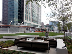
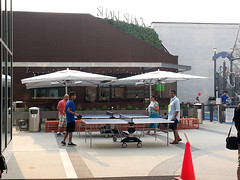
Befitting Tysons, The Plaza is a thoroughly contemporary update on the classic city square. There’s no marble statue in the middle, no grand fountain like in Dupont Circle. Instead, there are padded couches, small-scale artistic flourishes, and outdoor games.
One crucial difference between The Plaza and a traditional city square is who owns it. This may masquerade as civic space, but it’s clearly private property. Security guards patrol the square, and you can bet homeless people aren’t welcome to sleep on benches.
But still, The Plaza is a big step forward for Tysons. It’s a genuine gathering place, and people are using it. Even without the Metro connection, plenty of other people were hanging out nearby when I visited last weekend. It’s not the kind of place that a mere 20th Century office park would support.
DC’s most useless park is a parking lot in disguise
Capping an underground parking garage with a public park is such a nice idea. It’s a shame DC’s most prominent example is such a terrible park.
Spirit of Justice Park. Image from Google.
The South Capitol parking crater is undeniably one of DC’s most inappropriately underused plots of land. It’s 6 complete blocks of parking lots, all in a cluster mere steps from the US Capitol.
By all rights these blocks should be active and vital parts of downtown DC. Instead, they’re under the jurisdiction of the Architect of the Capitol, and thus off-limits to the normal rules of city building. In the vacuum of capitol complex land management, vast parking lots for Congresspeople and their staffs are a higher priority than housing, amenities, or attractive streetscapes.
So it’s nice that federal planners at least tried to spruce up this neighborhood-sized sea of asphalt with Spirit of Justice Park, a cap atop a two-block section of parking that’s covered with green space.
Unfortunately, it’s a lousy park.
The biggest problem is that rather than sink the parking below grade, the park is raised a level above the sidewalk. As a result, many people only see an imposing wall, and have no idea the park behind it even exists.
The sidewalk in front of the park. Image from Google.
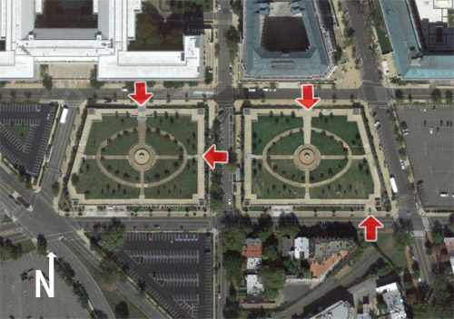
People who actually want to enter and use the park must find one of only four entrances over the entire two-block area. Of the four entrances, two face the congressional office buildings and one faces the street between the two park blocks (though you can’t walk between them directly), leaving only a single entrance on the south side facing away from the capitol complex towards the public city.
Meanwhile, there are no visible entrances facing east nor west.
Entrances to Spirit of Justice Park. Image originally from Google.
That’s not the only problem. With a parking garage directly beneath the grass, the park’s soil is too shallow to support trees large enough to provide shade or protection against wind. The park is uncomfortably hot in the summer, and cold in winter.
Finally, management apparently only cares about capitol complex workers, because the fountains at the center of each block are switched off over the weekend.
Small trees and a dry fountain hidden behind a wall. No people.
The overall message is that the public is barely tolerated in this park, not really welcome, and certainly not a priority. As a result, the public mostly stays away.
A park that’s not used is a useless park. We can do better.
Even if weather or careless use ruins them after one season, upright pianos aren’t particularly expensive. It would be completely practical for DC to buy one or two per year and put them in squares or circles around the central city. Roll them out in spring, and pack them back up around Thanksgiving.
The idea could work great in Farragut Square or along the Georgetown waterfront.
A potentially bigger holdup might be getting the National Park Service to allow it.
Other Dan is completely right. Just to throw my support behind his sensible arguments:
It’s not a pleasant place to be. Good urban parks need active streetscapes around them, with plenty of retail. The old Silver Spring turf worked well because it was at a location people wanted to hang out in. The transit center location on other other hand is surrounded by a parking garage, huge landscaped setbacks, blank walls, and loud, high-traffic highways next to which nobody wants to spend time. The edge conditions are awful. If you just built a park there the result would not be Dupont Circle. It would be this – dreary and dangerous.
There are already parks directly across the street in two directions. One north at 2nd and Colesville, and the other east on the Wayne Avenue side of the Discovery Building. Granted the Discovery park is privately owned and is often fenced off, but getting Discovery to open it up more would be a vastly better and cheaper outcome than taking land next to the transit center. In any event, the other one is open all the time.
Developing the site would actually produce a better park. Since parks should be in pleasant and active locations, good ones should be lined with pleasant buildings. The only way to line this site with pleasant buildings is to construct some pleasant buildings, and put a square in the middle. That’s a fine idea. Incidentally, that’s already the plan.
A park would increase car traffic. Yes, it’s true. The best way to decrease car traffic is to put as much development as close to major transit stations as possible. Displacing the planned development adjacent to the transit center with a park would mean that development happens somewhere else, almost certainly somewhere less transit accessible and by extension more car-dependent.
Buying this valuable land and turning it into a park has absolutely no upside. It would be expensive and it would be a bad park and it would screw over the transportation network. Please, Montgomery County, waste no more time on this terrible, terrible idea.
PS: At Rebuilding Place in the Urban Space, Richard Layman has an extensive discussion of Silver Spring park issues.
There was no mass snowball fight in Dupont Circle yesterday. Instead, Washingtonians celebrated the snow day by filling Dupont with dozens of snowmen and other snow sculptures.
There were two Washington Monuments, a US Capitol, snowman Barack Obama (aka Snowbama), a woman giving birth, a sphinx, and more. Enjoy these photos.
Support “The Diagonal” redesign option for Franklin Park
DC and the National Park Service (NPS) want feedback on their latest proposals to redesign Franklin Park. Of the 3 options on the table, the one titled “The Diagonal” is by far the best.
“The Diagonal” redesign option for Franklin Square. Image from National Park Service.
This proposal would introduce new paths leading diagonally from the corners of the park into its center. The center itself would feature a larger and better central fountain. Right now the center is poorly used, partly because access to it is circuitous, and the existing fountain is underwhelming (when people notice it at all).
Alone, these are big improvements. But this proposal also makes another strong change: It adds plaza space to the southwest corner of the park, along 14th and Eye Streets.
This proposal rightly accepts the reality of how that small part of Franklin Park is used, and modifies it accordingly.
The southwest corner is effectively a plaza already. With so many people using the bus stops on Eye Street, and entering the park from McPherson Metro station, the intended grass lawn there is more of a dirt patch than an actual lawn. Insisting it remain a lawn would be unrealistic, an eyesore, and would deprive the park’s users of what they really need. This proposal rightly accepts the reality of how that small part of Franklin Park is used, and modifies it accordingly.
Move the statue to 14th/Eye instead of K
Finally, The Diagonal plan moves the existing Commodore Barry statue from the 14th Street side to a more prominent location along K Street. This is a good change, but it would be even better to put the statue directly at the corner of 14th and Eye, to give the new southwest corner plaza a focal point.
I suggested these sort of changes in September. It’s encouraging to see them carried forward. They’re neither radical nor excessive. They retain the park’s existing strengths while tweaking its most important nodes.
The other options
Except for the welcome addition of a playground that’s common to all 3 redesign options, the other 2 alternatives are more conservative.
The option titled “The Center” would focus on cleaning up the existing park elements without making major changes. It would add a small plaza space along K Street, but nothing in the busy southwest portion of the square.
The other option, titled “The Edge”, adds a plaza and 2 small buildings along Eye Street, and makes some improvements to the central fountain. This would be better than the do-almost-nothing “Center” concept, but isn’t as strong as “The Diagonal.”
Send in comments
It’s not every day we get the chance to redesign one of downtown’s main public spaces. It’s important to get this right.
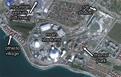
Know what you’re watching: Map of Sochi’s Olympic Village
Sochi’s main Olympic Village is 20 miles southeast from downtown Sochi, near the city’s airport. It’s home to the athlete residences, stadiums for the indoor sports, a theme park, and a huge rail station. The venues for mountain sports are 35 miles inland, near Krasnaya Polyana.
Satellite view of Sochi’s Olympic Village. Original image from Google.


 Comment on this at the version cross-posted to Greater Greater Washington.


