|
Special Features


Image Libraries


|
|
Blog
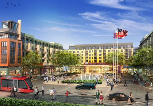
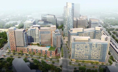
Shops begin to open at Brookland Metro developmentMonroe Street Market, the large multiblock development adjacent to Brookland Metro station, is making rapid progress. The first buildings are occupied, and shops are beginning to open.
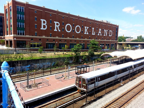
The landmark Brookland sign at Monroe Street Market.
The new town center will stitch together the residential neighborhood, Catholic University, and the Metro station like never before. Although it’s a smaller scale than what’s gone in at Columbia Heights, and will always be more of a local node than regional shopping mecca, it will be no less transformative to the livability of the neighborhood.
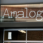
One of the first shops to open for business is Analog, a boutique and on-site crafting workshop selling, among other things, DC- and geography-themed paper goods. My wife is co-owner of Analog, and I couldn’t be more proud of her.
More small shops and artist studios will open through September, with the larger retailers coming in spring 2014. The largest will be a new Barnes and Noble bookstore, which will include a section for Catholic University textbooks.
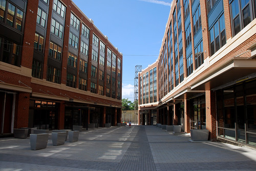
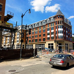
Here are a few more pictures of Monroe Street Market and Analog.
 |
 |
 |
 |
| Monroe Street Market’s Arts Walk (top), 2nd building (bottom left), and Analog (bottom center & right). |
 Cross-posted at Greater Greater Washington. Cross-posted at Greater Greater Washington.
September 6th, 2013 | Permalink
Tags: development

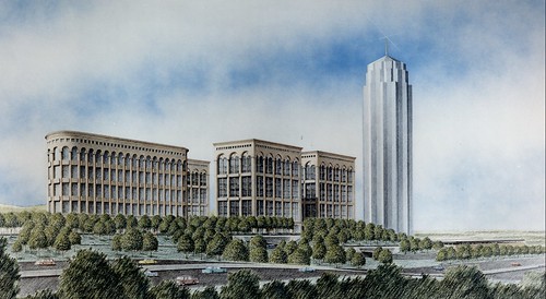
National Harbor’s colossal never-built skyscraperNational Harbor was originally going to be called Port America, and it almost included a skyscraper that might have been taller than the Washington Monument.
By 2008 when the first part of National Harbor opened, the concept of suburban town centers was tried and true. But developers have been trying to build a town center there since the mid 1980s. When they started, it was the most progressive of ideas.
The original plan for Port America dates from 1987. It would have included a neo-classical mixed-use town center in the same place as National Harbor’s waterfront, plus a large office park on the adjacent property that is now under-construction to become an outlet mall.
The office park would have included a 52-story trophy office tower. It would very likely have risen above the 555-foot Washington Monument, and definitely would have dwarfed the DC region’s current tallest office building, Rosslyn’s 384-foot 1812 North Moore.
 |
 |
 |
 |
| Port America. All images from Burgee-Jonhson. |
Cross-posted at Greater Greater Washington.
August 9th, 2013 | Permalink
Tags: development, history, urbandesign
Stadiums aren’t about the money
|
This doesn’t make money either.
Photo by \Ryan on flickr. |
Why do cities keep building stadiums, despite study after study showing they don’t make money? Simple: They’re cultural amenities that people want, and are willing to pay for.
When Mayor Gray announced the DC United stadium deal last month, he kicked off a public debate about stadium-building. Much of the debate has focused on whether or not the deal will make DC any money.
The fact that stadiums often lose money is largely irrelevant. So do museums, libraries, and opera houses. Stadiums fall into the same category.
Smart communities try to squeeze some economic development out of stadium deals, because they may as well, but that’s always a side benefit. At the end of the day it isn’t the main reason cities build stadiums.
It’s true that the privately-owned sports franchises that use stadiums reap a disproportionate benefit from public financing deals, but that’s also irrelevant to the stadium-building decision. Pro sports franchises are also cultural amenities that lots of people want and will pay for.
This is why decades of policy wonk hand-wringing over the money has rarely convinced anyone to stop building stadiums. That criticism, true as it is, simply does not invalidate the perceived benefit.
Cross-posted at Greater Greater Washington.
August 6th, 2013 | Permalink
Tags: development, economy, government
Walter Reed’s main street should be Georgia AvenueThe Walter Reed campus is one of the largest redevelopment sites in the District. It may one day become the biggest node of activity between Columbia Heights and Silver Spring. Three teams are competing for development rights, and it’s now up to DC to select which team will get the opportunity to build.
Hines’ proposal. All images from the Walter Reed Local Development Authority.
Much of the media coverage of the 3 options has so far focused on which of them might accommodate a Wegmans grocery store. But the physical form matters more than the individual tenants. To function as a neighborhood downtown, Walter Reed must be walkable, as transit-oriented as possible, and fully integrated with the surrounding neighborhood.
Specifically, Georgia Avenue must be the main street. Developers of large properties often try to mimic shopping malls and pull the center of activity inwards, towards the center of their own site, and away from the edges. That’s why Ellsworth Drive became the center of Silver Spring, and why CityCenterDC’s central plaza won’t face a public street.
But that arrangement makes a place feel artificial, and limits the spillover economic benefits to surrounding parcels. It also pushes more people to drive, when the main transit spine isn’t front and center to the densest cluster of development.
With no Metro station at Walter Reed, and Takoma station a long walk to the east, the major transit access will be from Georgia Avenue. First the 70-series bus line, and eventually streetcar. Since Georgia Avenue is both the transit spine and the community’s existing main street, it should be the heart of activity for Walter Reed.
Hines and Roadside proposals
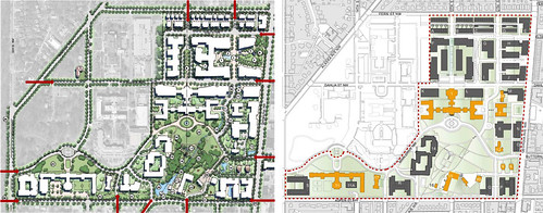
Hines (left), Roadside (right).
The Hines and Roadside concepts are similar. Both propose the southern half of the property be suburban in character, with a town center clustered in the northern half.
Hines shows a public park fronting on Georgia Avenue, which would be a nice amenity. But that park has the unfortunate effect of pushing the hub of its town center back nearly 2 blocks away. One rendering even shows the streetcar pulled off Georgia Avenue, rerouted to better serve Walter Reed and more poorly serve everywhere else.
It’s harder to tell from the plans whether the Roadside proposal treats Georgia Avenue, Dahlia Street, 12th Street, or 13th Street as the main street. It appears to be about the same density as Hines, but without the town center park.
Forest City proposal
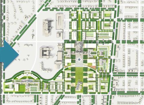
Forest City.
Seemingly the densest of the 3 proposals, Forest City is the only finalist team that attempts to urbanize the southern half of the property. It also maximizes building frontage along Georgia Avenue, while providing ample parks along 13th Street.
Forest City does propose to make Dahlia Street a retail spine, while they do not say what sort of land uses would front on Georgia Avenue. There may be enough added density in their proposal to support both Dahlia and Georgia as retail spines, or maybe they’d make Georgia all residential. The former would be fine, the latter wouldn’t.
At first glance, Forest City’s proposal appears to be the best of the 3, but all the development teams must release more details, especially their proposed ground-floor land uses for every street.
No matter which team is ultimately picked, a town center near Georgia and Dahlia is better for DC than what’s there today.
Cross-posted at Greater Greater Washington.
July 31st, 2013 | Permalink
Tags: development, streetcar, transportation
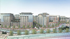
To build a soccer stadium, DC will swap the Reeves CenterDC has agreed to a preliminary deal to build a dedicated soccer stadium at Buzzard Point, and to redevelop the Reeves Center at 14th and U streets NW with a new mixed-use building.
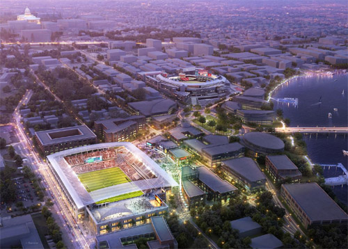
Rendering of a Buzzard Point soccer stadium. Image from DC United.
Under the deal, the stadium would be located at the southern base of Potomac Avenue SW, just 4 blocks from Nationals Park. It would seat 20,000-25,000 people, and cost around $150 million to build. DC United would pay for construction, but the District would donate the land.
Development firm Akridge currently owns the land for the stadium. Instead of buying the land outright, DC would swap it for the Reeves Center. Akridge would then tear down and redevelop the Reeves Center, while United would build a stadium at Buzzard Point.
The deal must still be approved by the DC Council.
Is this a good idea?
Is Buzzard Point the right place for a stadium? Usually it’s not a great idea to put two large stadiums so close to each other, because when so much land is given over to sports, there’s not enough left over to build a functioning mixed-use neighborhood. That’s a major problem with Baltimore’s Camden Yards area, with the South Philadelphia Sports Complex, and with most multiple-stadium complexes.
But Buzzard Point may be different. Nationals Park has helped induce strong redevelopment east of South Capitol Street, and along M Street SE/SW, but the west side of South Capitol Street has lagged behind. The west side clearly functions as a different place, and a stadium there could help.
On the other hand, maybe the west side of South Capitol Street hasn’t redeveloped as much precisely because Nationals Park superblock is a barrier.
From a transportation perspective, Buzzard Point makes sense. Although it’s further from a Metro station than Nationals Park or RFK, it’s still within walking distance. And actually, a little bit of distance is a good thing, since it means soccer fans will pass by retail areas between the stadium and Metro, and that the most valuable land nearest the station can still be used for mixed-use development.
On top of the Metro connection, DC is planning for both the Georgia Avenue and Anacostia streetcar lines to terminate at Buzzard Point, directly adjacent to the proposed stadium site.
As for the Reeves Center, it cannot be redeveloped soon enough. A large city office building was a useful and necessary investment along U Street in the 1980s, when central DC was declining. But now the neighborhood is booming, the land is in high demand, and the Reeves Center is obsolete.
In a perfect world, I still think Poplar Point would have been a better location for a soccer stadium. But in the real world, Buzzard Point works. Since DC taxpayers won’t be on the hook to pay for construction, let’s do it.
Cross-posted at Greater Greater Washington.
July 25th, 2013 | Permalink
Tags: development
Fairfax still wants a real center at Vienna MetroWestDevelopers floated a plan last month to drastically downscale the town center at Vienna MetroWest, but Lynda Smyth, the county supervisor for the area, said she never approved such a change, nor would the Board of Supervisors likely ever do so. Developers say they’re still committed to the full town center, but can’t do it right away.
The downscaled proposal, with single-story buildings fronting onto parking lots. Image from Paraclete Realty.
Developers spoke with county supervisors and residents about the plans at a public meeting on June 18. According to resident Eric Bleeker, the room was packed, and many attendees came because they’d heard about the plan on Greater Greater Washington. Supervisor Smyth said she hadn’t seen the new proposal until it was posted to Greater Greater Washington, and would almost surely not approve it.
According to Tim Alexander of development firm Clark Realty, the downscaled proposal is supposed to be temporary. Clark still wants to build the full town center, but can’t find tenants for the originally proposed office buildings in the current economy. In the mean time, his company doesn’t want to leave that land empty for what could be years.
“The negativity to the plan was immense,” said Bleeker, who lives at MetroWest. “After a good verbal lashing from Supervisor Smyth, the Clark representative spoke of wanting to work with the county on alternative ideas, and threw out pop-up retail.”
What now?
Unfortunately, Clark is between a rock and a hard place. Plan A, the full town center, is impossible in the short term due to the economy. Plan B, the downscaled version, is rightly unpopular. What could work for Plan C?
It would be short-sighted to simply build residential towers in the town center instead of offices. MetroWest would lose its planned mixed-use character. It would be harder to keep retail spaces full over the long term with neither daytime workers in walking distance nor a lot of car traffic passing by.
So temporary single-story buildings may be the only viable near-term option, even if “temporary” means years. But if that’s the case, Clark should strive to build a bona fide main street, rather than a couple of retail pad sites, with half of them fronting onto parking lots.
Even if parking lots are necessary, the main strip of activity should be the pedestrian-oriented walkway down the middle of the site, leading to the Metro station. All stores should front directly onto the main street, and there shouldn’t be any gaps in the street wall where a parking lot comes right up to the front.
If the full town center is years away then a temporary single-story retail town center may be an unfortunate reality, but even if so, Clark can do better.
Cross-posted at Greater Greater Washington.
July 3rd, 2013 | Permalink
Tags: development, urbandesign
Baltimore’s suburban downtowns emerge as more urban
|
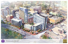
Towson Row. Image from Baltimore County. |
Bethesda, Silver Spring, and Arlington are some of the best suburban downtowns in America. Baltimore’s suburbs, by comparison, have lagged behind. But with large infill projects coming to Towson and Columbia, Baltimore’s most walkable suburbs may soon catch up with DC’s.
In Towson, 1500 new residential units have opened in the past 4 years, with the largest redevelopment, Towson Row, announced just last week. The change has been enough that the Maryland Transportation Administration is now considering a Towson circulator bus network.
Columbia has further to go. Towson at least has a traditional grid of streets around which to build. Columbia, by comparison, was planned in the mid-20th Century around a mall. All Towson really needs is more buildings; Columbia must be reworked from the ground up.
|
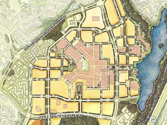 Downtown Columbia master plan. Image from Howard County. Downtown Columbia master plan. Image from Howard County. |
But they are getting there, slowly. In 2010 Howard County adopted a master plan to make downtown Columbia more urban. And now, actual projects are in the works.
Developers are moving forward with a 9-story infill project after plans for a 22-story one on the same property fell through. The shorter project is actually denser. It will have 160 apartments, 12,000 square feet of retail, and 130,000 square feet of office space, compared to 160 apartments, 11,000 square feet of retail, and no office space in the 22-story version. The 22-story tower was proposed nearly 10 years ago, and was a more suburban design.
Unfortunately, for the foreseeable future both Towson and Columbia will continue to lack an important piece of the urban puzzle: regional transit. DC’s suburban downtowns have the advantage of Metro, but Baltimore’s Metro is smaller, and serves neither Towson nor Columbia. Long range plans call for an eventual light rail connection to both places, but that’s decades away.
Cross-posted at Greater Greater Washington.
June 25th, 2013 | Permalink
Tags: bus, development, lightrail, master planning, transportation
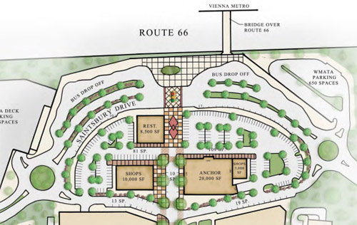
Vienna Metro town center won’t have a town centerOutside of Tysons Corner, Vienna MetroWest is Fairfax County’s greatest experiment yet in transit oriented development. But now it appears developers have scaled back, and may build car-oriented retail instead.
Original plan (left), and current plan (right). Images from Clark Realty and Paraclete Realty.
MetroWest was initially approved in 2006 after years of debate as a dense, walkable town center adjacent to Vienna Metro station. It was Fairfax County’s first big smart growth win.
With construction of the residential sections underway, the town center seemed close to finally, finally happening. But now that it’s time to actually start leasing spaces, the town center development plan looks a lot different.
Instead of dense, walkable midrises, the are single-story retail buildings surrounded by surface parking lots. Instead of an urban town center, it’s a glorified strip mall. What happened?
One can speculate. A recession hit, competing developments at nearby Dunn Loring Metro opened first, and the market changed.
Developers do often build single-story retail as a “temporary” placeholder until they’re ready for more intense uses. That was the idea behind the Kentlands town center in Gaithersburg, which is now redeveloping parcel by parcel. But “temporary” in this case can mean 20 years.
For people who bought homes at MetroWest based on the promise of a strong town center nearby, the potential of something better years in the future is little consolation.
Cross-posted at Greater Greater Washington.
June 14th, 2013 | Permalink
Tags: development, land use
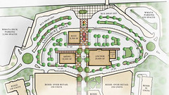
Langley Park transit center finally moving forwardMaryland has awarded a construction contract for the Langley Park transit center.
Langley Park is currently the busiest bus transfer location in the region that isn’t connected to a Metro station. But it’s a mess. Bus stops are spread all around the busy crossroads of New Hampshire Avenue and University Boulevard. Transit users hoping to transfer have to cross up to 14 lanes of traffic, and have to memorize which curbside bus stops their route uses. It’s a complicated and dangerous situation.
Solution: bus station.
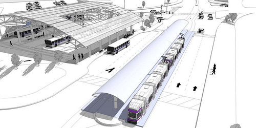
Langley Park transit center, including future Purple Line connection.
All images from Maryland MTA.
To solve this problem, Maryland has been planning for years to build a Langley Park bus station. The station would centralize all bus routes in the area under a single building, with vastly improved customer amenities.
Funding for the station was lined up in 2010 when MTA received a TIGER grant for it, but a land ownership issue delayed construction until now. Groundbreaking is expected this summer, with completion in fall of 2015.
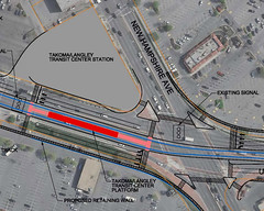
Location map. |
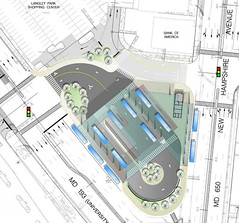
Transit center plan. |
May 31st, 2013 | Permalink
Tags: bus, development, lightrail, transportation
Tysons Corner skyscraper will be region’s tallestA proposed skyscraper in Tysons Corner will be 435 feet tall, making it the tallest in the DC region, and first to breach the 400 foot threshold. The building is proposed as part of the SAIC redevelopment, adjacent to the Silver Line’s Greensboro Metro station.
SAIC Westpark. Image by FXFOWLE, published online by The Tysons Corner.
Traditionally, the tallest skyscrapers in the region have been in Rosslyn. But Rosslyn is in the flight path to National Airport, so buildings there can’t rise higher than 400 feet. A bevy of development projects in Rosslyn, Alexandria, Tysons, and North Bethesda are in the 300-400 foot range, but this is the first serious proposal to crack 400 feet.
Outside the DC region, Maryland’s tallest building is 528 feet, and Virginia’s is 508 feet. Richmond’s is 449 feet.
Cross-posted at Greater Greater Washington.
May 7th, 2013 | Permalink
Tags: development
|
Media


Site
About BeyondDC
Archive 2003-06
Contact
Category Tags:
Partners
|


