Special Features

Image Libraries

Blog
Metro’s Richard Sarles announces retirement


Richard Sarles. Photo by thisisbossi on Flickr.

WMATA General Manager Richard Sarles announced at today’s Metro board meeting that he will retire, effective January, 2015.

The move comes as a surprise, since in 2013 Sarles agreed to a contract extension that would have kept him on the job until 2016. But not too much of a surprise: He’s 70 years old and has always said he didn’t intend to stay at WMATA long.

Sarles took charge of WMATA in 2010 and oversaw a significant rebuilding and safety-related overhaul of the transit system.

Metro board chairman Tom Downs says WMATA will conduct a nationwide search for Sarles’ replacement.

 Cross-posted at Greater Greater Washington.


September 24th, 2014 | Permalink
Tags: government, metrorail, people, transportation


Two maps that explain what DC might look like as a state

On Monday, Congress considered DC statehood. But what would DC actually look like if it became a state?


Maps by Geoffrey Hatchard for Neighbors United for Statehood.

The most likely path to statehood for the District would shrink the federal city to a tiny section surrounding the National Mall and other federal properties. That section would remain not part of any state. The rest of the city would then become the 51st state, possibly called New Columbia.

Here’s a zoom-in to what would become the remaining federal city.


 Cross-posted at Greater Greater Washington.


September 17th, 2014 | Permalink
Tags: government, maps


Will Cantor’s loss push congressional Republicans to balk on transportation compromise?

Last night, US House majority leader Eric Cantor lost the Republican primary to a tea party challenger who painted Cantor as too willing to compromise with Democrats. Cantor’s loss makes this summer’s looming congressional fight over transportation funding all the more unpredictable.


US Highway Trust Fund balance. If Congress doesn’t act soon, money will run out. Image from USDOT.

MAP-21, the federal transportation funding bill, expires in October. But USDOT will begin running out of money in August. Without a bipartisan bill to add new money, federal transportation funding will trickle to a halt.

Transportation wasn’t a major issue in Cantor’s election, but immigration reform was. Cantor mostly opposed immigration reform, but he briefly contemplated compromise, giving his more conservative opponent David Brat an opening to attack.

Some pundits fear that will push every other House Republican away from compromise in general, and grind whatever progress Congress was making on anything to a halt.

From an immigration perspective that probably makes little difference; House Republicans were not going to compromise anyway. But it could make a huge difference for transportation.

Transportation funding was a non-partisan issue in the 20th Century. Every 6 years Congress would pass a transportation bill with broad support from both parties. But in recent years, amid declining gas tax revenue and increasing need for supplemental funding, transportation has become a partisan spark.

Congress seemed primed to act, but now it’s an open question

Up until Cantor’s defeat, the general assumption in the transportation world has been that Congress would do something this summer. “Something” might mean a long term solution like a new bill and new taxes. Or it might mean a band-aid, like an extension of MAP-21 with an infusion of federal general fund dollars. Either way, Congress appeared to be making some progress.

But now? House Republicans might very well cease all legislative activity, and hope to ride out the rest of election season without upsetting their conservative base.

Polls show that raising money for transportation is popular, and voters rarely punish officials for doing so. But that may not matter to Republicans concerned about attacks from the extreme right.

While in Congress, Cantor fought against progressive transportation funding. But in this case his personal vote, and even his leadership on the specifics, might be less important than the simple fact that he was probably willing to advance a bill.

On the other hand, maybe the Republican establishment will take this as a call to arms, and moderate legislators will become more powerful. But that seems unlikely the day after the biggest tea party victory of the season.

 Cross-posted at Greater Greater Washington.


June 11th, 2014 | Permalink
Tags: funding, government, people, transportation


If stars align, the Silver Line might open as soon as July 28. But everything’s not perfect yet

WMATA still has not announced an official opening date for the Silver Line. But if crews can work out remaining construction problems quickly, the new Metro line could, potentially, maybe open for passengers as soon as Monday, July 28.


Greensboro Metro Station. Photo from Stephen Barna of the Dulles Corridor Metrorail Project.

That’s if workers complete all remaining construction as quickly as possible, and there are no hiccups during equipment testing or training, and the weather is good. So far, the last bits of construction aren’t quite on target to wrap up so soon.

The union is ready for a July opening

According to WMATA’s union president Jackie Jeter, Metro has instructed train operators to begin scheduling Silver Line shifts for “simulated service” starting on July 20.

Simulated service is the last step before opening for passengers. It’s a training and testing phase, during which Metro will operate the Silver Line as though it were open, but without carrying passengers.

Simulated service is supposed to take a week, so if it does begin on July 20, and there are no last minute problems, everything could be done and ready to go by the 28th.

This would be a month early, and it may still not happen

According to WMATA’s official schedule, final construction and testing could last through the end of August. To actually finish it all in July would be early, per that timeline.

Will they make it? During WMATA’s weekly conference call with reporters yesterday, Metro deputy general manager Rob Troup not only declined to confirm the July 20 date, but also cautioned that work crews are behind schedule on some of the last tasks.

Most of the remaining issues are minor. Tasks include painting hand rails and checking the public address systems, among others. The largest remaining task may be to correct water drainage problems on the station platforms.

So the July 28 date is by no means guaranteed, and it’s really not a delay if opening slips to August, or even September.

Thanks to good communication, we know what to expect

This timeline jives perfectly with what Troup said when Metro accepted control of the Silver Line on May 27. At the time, he said Metro budgeted 90 days for final testing and construction, but that they might not need the entire time.

WMATA gave the public a realistic range for how long this will take. Now that more detailed rumors are flying, we have the necessary knowledge to evaluate them. We know that July 28 is an achievable but optimistic timeline. We know that if it’s not met and opening comes a month or two later, that’s not a problem.

We know that dotting every “i” and crossing every “t” on a complex infrastructure project like the Silver Line is impossible to completely predict. But we know the Silver Line is getting really, really close.

So I’m tempering my expectations, but I’m still excited.

 Cross-posted at Greater Greater Washington.


June 10th, 2014 | Permalink
Tags: government, metrorail, transportation


The H Street streetcar will take even longer to open than many thought. It’s past time for DDOT to be more honest

There’s more bad news for DC streetcars: The latest estimates show the H Street line may not open until early 2015. This isn’t an additional delay, but rather seems to be simply a more genuine timeline of how long the remaining work will take. That’s a step forward. Unfortunately, DDOT is still not being fully forthright about what’s going on.


DC streetcars at the Anacostia testing & commissioning site.

> Continue reading at Greater Greater Washington

June 5th, 2014 | Permalink
Tags: government, streetcar, transportation


MoveDC plan proposes more cycletracks, transit, and tolls. Will it actually happen?

The latest draft of DDOT’s citywide transportation plan, moveDC, calls for a massive expansion of transit and cycling facilities throughout the District, plus new tolls on car commuters. If the District adopts it, the plan will become one of America’s most progressive.


The moveDC plan summary map. All images from DDOT.

DDOT released the latest version of moveDC last Friday, launching a month long public comment period in anticipation of a DC Council hearing on June 27. Following that, the mayor will determine any changes based on the comment period, with final adoption anticipated this summer.

What’s in the plan

Amid the hundreds of specific recommendations in the plan, three major proposed initiatives stand out:

  • A vastly improved transit network, with 69 miles of streetcars, transit lanes, and improved buses, plus a new Metrorail subway downtown.
  • A massive increase in new cycling infrastructure, including the densest network of cycletracks this side of Europe.
  • Congestion pricing for cars entering downtown, and traveling on some of DC’s biggest highways.

Transit


Proposed high-capacity transit network (both streetcars and bus). Blue is mixed-traffic, red is dedicated transit lanes.

The plan proposes to finish DC’s 22-mile streetcar system, then implement a further 47-mile high-capacity transit network that could use a combination of streetcars or buses. That includes 25 miles of dedicated transit lanes, including the much requested 16th Street bus lane.

Although the proposed high capacity transit corridors closely mirror the 37-mile streetcar network originally charted in 2010, there are several new corridors. In addition to 16th Street, moveDC shows routes on Wisconsin Avenue, both North and South Capitol Streets, H and I Streets downtown, and several tweaks and extensions to other corridors.

The plan endorses WMATA’s idea for a new loop subway through downtown DC, but explicitly denies that DC can fund that project alone.

MoveDC also shows a network of new high-frequency local bus routes, including Connecticut Avenue, Military Road, Alabama Avenue, and MacArthur Boulevard.

Bicycles

MoveDC also includes a huge expansion of trails and bike lanes, especially cycletracks.


Proposed bike network. The pink lines are cycletracks.

Under the plan, DC would have a whopping 72 miles of cycletracks crisscrossing all over the city. From South Dakota Avenue to Arizona Avenue to Mississippi Avenue, everybody gets a cycletrack.

Meanwhile, moveDC shows major new off-street trails along Massachusetts Avenue, New York Avenue, and the Anacostia Freeway, among others.

Tolls for cars

Congestion pricing is clearly on DDOT’s mind, with multiple proposals for new variable tolls in the plan.


Proposed downtown cordon charge zone.

The most aggressive proposal is to a declare a cordon charge to enter downtown in a car. This idea has worked in London and has been discussed in New York and San Francisco, but so far no American city has tried it.

Meanwhile, some of the major car routes into DC would also be converted to managed lanes. Like Maryland’s ICC or Virginia’s Beltway HOT lanes, managed lanes have variable tolls that rise or fall based on how busy a road is.

MoveDC proposes managed lanes on I-395, I-295, New York Avenue, and Canal Road.

What will the council think?

DDOT has produced a very strong plan, but is it going anywhere? The DC Council will discuss moveDC on June 27, at which time we’ll find out if the same people who pulled the rug out from under streetcar funding are interested in progressive policy-making, at least.

Even if DC does adopt this plan, whether the council will actually provide the funds necessary to build it is anybody’s guess.

Correction: An earlier version of this story reported the DC Council will approve or deny this plan. Authority to approve it actually rests solely with the mayor.

 Cross-posted at Greater Greater Washington.


June 2nd, 2014 | Permalink
Tags: bike, BRT, bus, government, lightrail, master planning, metrorail, roads/cars, streetcar, transportation


DC’s most useless park is a parking lot in disguise

Capping an underground parking garage with a public park is such a nice idea. It’s a shame DC’s most prominent example is such a terrible park.


Spirit of Justice Park. Image from Google.

The South Capitol parking crater is undeniably one of DC’s most inappropriately underused plots of land. It’s 6 complete blocks of parking lots, all in a cluster mere steps from the US Capitol.

By all rights these blocks should be active and vital parts of downtown DC. Instead, they’re under the jurisdiction of the Architect of the Capitol, and thus off-limits to the normal rules of city building. In the vacuum of capitol complex land management, vast parking lots for Congresspeople and their staffs are a higher priority than housing, amenities, or attractive streetscapes.

So it’s nice that federal planners at least tried to spruce up this neighborhood-sized sea of asphalt with Spirit of Justice Park, a cap atop a two-block section of parking that’s covered with green space.

Unfortunately, it’s a lousy park.

The biggest problem is that rather than sink the parking below grade, the park is raised a level above the sidewalk. As a result, many people only see an imposing wall, and have no idea the park behind it even exists.


The sidewalk in front of the park. Image from Google.

People who actually want to enter and use the park must find one of only four entrances over the entire two-block area. Of the four entrances, two face the congressional office buildings and one faces the street between the two park blocks (though you can’t walk between them directly), leaving only a single entrance on the south side facing away from the capitol complex towards the public city.

Meanwhile, there are no visible entrances facing east nor west.


Entrances to Spirit of Justice Park. Image originally from Google.

That’s not the only problem. With a parking garage directly beneath the grass, the park’s soil is too shallow to support trees large enough to provide shade or protection against wind. The park is uncomfortably hot in the summer, and cold in winter.

Finally, management apparently only cares about capitol complex workers, because the fountains at the center of each block are switched off over the weekend.


Small trees and a dry fountain hidden behind a wall. No people.

The overall message is that the public is barely tolerated in this park, not really welcome, and certainly not a priority. As a result, the public mostly stays away.

A park that’s not used is a useless park. We can do better.

 Cross-posted at Greater Greater Washington.


May 27th, 2014 | Permalink
Tags: government, parks, urbandesign


NFL stadiums belong in the suburbs

Should Washington’s football team relocate back to Washington? The DC Council is considering replacing RFK with a new stadium, hoping to lure the team back to DC, from Maryland.

It’s a terrible idea.


FedEx Field and its acres of parking. Photo by the US Navy.

Some people will no doubt oppose this idea simply because it’s expensive. But that’s not the problem. Stadiums are cultural amenities that people want, so it’s appropriate for cities to subsidize them sometimes.

This is a terrible idea because football stadiums specifically don’t fit well in cities. NFL stadiums are only used for 8 home games per year, and need large surface parking lots to accommodate the tailgating culture ingrained into football fandom.

The RFK site may not be in the middle of a walkable neighborhood, but surely there are better uses for it than a rarely-used stadium and vast parking lots.

I’m glad we have an NFL team in the region, but let’s leave their stadium in the suburbs.

 Cross-posted at Greater Greater Washington.


February 26th, 2014 | Permalink
Tags: development, government, urbandesign


Harriet Tregoning taking job at HUD

click to enlarge
Photo from thisisbossi on flickr.

Harriet Tregoning, Director of the DC Office of Planning, is resigning to take a job in the Obama administration as the Director of the HUD Office of Sustainable Housing and Communities.

The nation’s gain is DC’s loss. Tregoning has been one of the strongest regional voices for urbanism, transit, and smart growth.

With Arlington’s Chris Zimmerman also leaving local government this month, DC-area urbanists have big shoes to fill indeed.

February 4th, 2014 | Permalink
Tags: government, people


9 suggestions to change the height limit

Congress is considering whether or not to change DC’s height limit. Here are 9 suggestions that will help the city get the most benefit out of changing (but not eliminating) its height regulations.


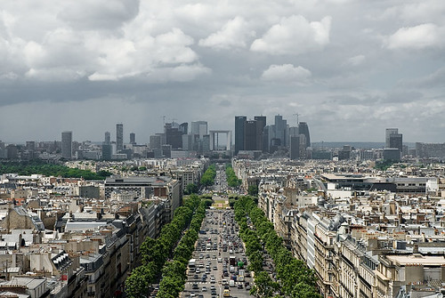
Paris’ La Defense skyline. Photo by KJ Vogelius on flickr.

Much of the debate about the height limit has settled into two opposing camps, those who want taller buildings, and those opposed to any change. But it doesn’t need to be so black and white.

Regulations can change in practical and beneficial ways, without destroying Washington’s unique layout. If Congress repeals or changes the DC Height Act, the District will be free to regulate height in much more flexible ways.

That in mind, here are some suggestions that Congress and the DC Council should consider as they move forward.

1. Don’t eliminate, calibrate

Even though eliminating all height limits completely isn’t anyone’s proposal and has never been seriously on the table, it’s worth saying up front just to be clear. There are good reasons to regulate height, but our existing laws are not necessarily the ideal set. We can make them more ideal with some fine tuning.

2. Target development where we want it

Many assume raising the height limit would result in taller buildings everywhere, or all over downtown, but that need not be the case. It would be smarter to pick specific areas where we want to encourage more development, and only increase the limit there.

The city can raise the limit only on blocks with a Metro station entrance, for example, or only within 1/8 mile of Metro stations with low existing ridership, or only near Farragut Square, or only in Anacostia. Whatever.

No doubt where to allow them would be a contentious question, but the city already has many regulations encouraging or discouraging development in certain areas. There’s no reason the height limit can’t be used in the same way. We can be selective.

3. Grant a residential bonus for downtown

Downtown DC has no trouble attracting development, but office is usually more profitable than residential, so downtown is often packed during work hours but pretty empty in the evenings. More residential would help downtown stay active on evenings and weekends, not to mention reduce the capacity stress on our transportation network by allowing more people to live close to their work.

But under current rules, developers often can’t justify using floor space under the height limit for residential when office is more lucrative. If they got a bonus for residential, allowing them to build taller only if some or all of the added height were used for apartments, that would benefit everyone.

4. More offices can go downtown, but also other places

We want a lot of office buildings downtown because that’s where our regional transportation system converges. But we also want office buildings outside downtown so residential areas don’t empty out during work hours, and to encourage a healthy economy throughout the city.

Uptown nodes like Bethesda and Clarendon are good for the region and would be good for the city, and would happen in DC if we allowed them to. So while it may be desirable to allow taller buildings in some parts of downtown sometimes, it’s also desirable to encourage office development elsewhere as an anchor for uptown commercial districts.

5. Be inclusive of affordable housing

Height limit opponents say taller buildings will make DC more affordable, because it will increase the supply of housing, thus helping to address rising demand. Supporters of keeping it say tall buildings will make DC more expensive, because new development is almost always expensive. They’re both right, but those points aren’t mutually exclusive.

New buildings are indeed almost always expensive, because it costs a lot to build a skyscraper, and developers need to turn a profit within a few years.

But new buildings eventually become old ones, and this isn’t a short-term decision. Buildings that are expensive at first often become the next generation’s affordable housing. Part of the reason DC has an affordable housing problem now is that we didn’t build enough new buildings a generation ago. If we don’t build enough new units now, the next generation will be out of luck too.

In the mean time, we can solve the short-term affordability problem with inclusive zoning; in exchange for allowing taller buildings, the city should require some of their units to be affordable. Win-win.

6. Require good architecture

Some who want to change the height limit say regulations hurt DC’s architecture, resulting in boring-looking buildings. Meanwhile, many others hate tall buildings because so many skyscrapers are ugly. Both arguments are equally bad, because the world is full of both great and ugly buildings of every height.

But there’s no denying that tall buildings stand out, and thus become landmarks whether beautiful or ugly. To ensure we get the former rather than the latter, DC (or even NCPC) could require aesthetic review & approval for the design of any building above a certain height.

That sounds cumbersome, but it’s standard practice in many cities, and DC already does it in some neighborhoods.

A city the size of DC wouldn’t want to insist on aesthetic review for every building, but there’s no good reason DC can’t do it for tall ones.

Of course the devil is in the details. To use this sort of oversight, DC would have to establish design guidelines that tell architects what the city will approve or deny. That could be contentious, and might not be the same everywhere in the city.

7. Preserve historic facades and encourage entrances

Frequent, unique-looking entrances are incredibly important for quality walkable urbanism. One problem with tall buildings is many are so wide that they’re boring to walk next to at the ground level. The minimalist facades of modern architecture compound the problem.

This is why the urbanism in Georgetown is better than Rosslyn. It’s not that Rosslyn has buildings that are too tall, it’s that Rosslyn’s buildings are too wide, and too bare at the ground level.

While it’s not practical for tall buildings to change completely every 25′ the way rowhouses in Georgetown do, their ground floors can be designed to look and function as smaller buildings, and historic buildings can be integrated into larger developments above.

This may not strictly be a height limit issue, but it’s a good way to ensure that taller buildings improve the streetscape. It can be accomplished using the design guidelines and architectural review process outlined above.

8. Outlaw surface parking lots

Surface parking lots are the bane of walkable urbanism, but they’re common in almost every skyscraper-heavy downtown in America, because one large building can sap up years worth of demand, leaving developers of other properties waiting in limbo for reason to build.

Many developers in downtowns around the US opt to leave land nearly empty rather than fill it with short buildings, on the chance that they may strike it big with the next big once-a-generation mega skyscraper. Surface parking lots provide a convenient way to use that land in the mean time.

This is a big problem, and DC is not immune. In 2008 the developer of what’s now the shiny office building on the northwest corner of Connecticut Avenue and K Street wanted to use that land as a parking lot.

Outlawing surface parking lots in areas where tall buildings are permitted would go a long way towards ensuring downtown DC never looks anything like this.

9. Protect the iconic monuments

Development economics are important, but they’re not the only thing. The most valuable land in DC is probably the White House Ellipse, but we’re not going to put skyscrapers there. DC’s skyline view of the Capitol and Washington Monument is one of the world’s most iconic, and should of course be preserved.

But taller buildings in Farragut Square or Brookland or Anacostia wouldn’t impede that view any more than they do in Rosslyn, and La Defense did not destroy Paris.

We can, and should, allow taller buildings where they’re most appropriate, while protecting the views that define our city.

 Cross-posted at Greater Greater Washington.


October 30th, 2013 | Permalink
Tags: architecture, government, land use, preservation, proposal, urbandesign


Media


Site
About BeyondDC
Archive 2003-06
Contact

Search:

GoogleBeyondDC
Category Tags:

Partners
 
  Greater Greater Washington
 
  Washington Post All Opinions Are Local Blog
 
  Denver Urbanism
 
  Streetsblog Network


BeyondDC v. 2013d | Email | Archive of posts from 2003-2006