Maps
 
  Unbuilt Highways
DC’s proposed but never built highways.
 
  Census Tract Density
Population density maps for census tracts within the 20 largest US urbanized areas.
 
  Other maps
View the full maps library.


Image Library
 
  Transportation
Transit, bikes, roads, and more. Sorted by mode and location.
 
  Urbanism
Cities and neighborhoods. Sorted by location.
 
  Flickr Flickr
View BeyondDC's full flickr photostream.


Other Features
 
  Frequent Transit Maps
Links to all known US and Canadian frequent transit maps, official and unofficial.
 
  Streetcars vs Buses
The differences between them, and why streetcars are often better.
 
  Archived features
Other features.

Blog
DC area 15-minute bus map

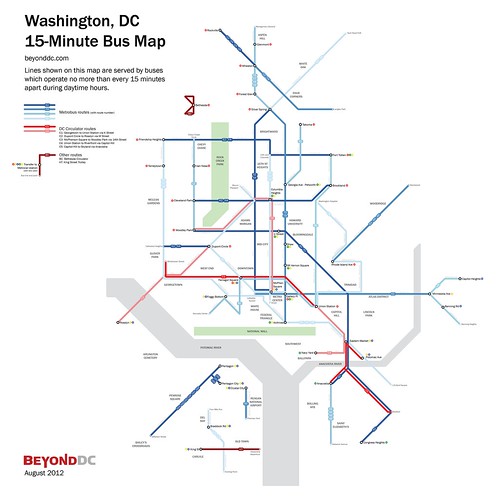
Back in 2010, WMATA produced a 15-minute bus map that showed bus routes with frequent service throughout the day. That map was just for planning purposes, but it’s such a useful idea that I took the next step, and turned it into a more user-friendly diagram.

In addition to Metrobus routes, this map also shows other frequent bus services in the region, including DC Circulator, Bethesda Circulator, and the King Street Trolley.

Cross-posted at Greater Greater Washington.


August 10th, 2012 | Permalink | {num}Comments
Tags: bus, featured post, maps, transportation


Twitter


Site
About BeyondDC
Archive 2003-06
Contact

BeyondDC via XML RSS

Search:

GoogleBeyondDC
Category Tags:

Partners
 
  Greater Greater Washington
 
  Washington Post All Opinions Are Local Blog
 
  Denver Urbanism


Blogs about urban issues in and around Washington, DC

Urbanist blogs nation-wide

PLANetizen Top 50 Website 2003


BeyondDC v. 2013a | All rights reserved | 2003-2006 archive | Contact |