Maps
 
  Unbuilt Highways
DC’s proposed but never built highways.
 
  Census Tract Density
Population density maps for census tracts within the 20 largest US urbanized areas.
 
  Other maps
View the full maps library.


Image Library
 
  Transportation
Transit, bikes, roads, and more. Sorted by mode and location.
 
  Urbanism
Cities and neighborhoods. Sorted by location.
 
  Flickr Flickr
View BeyondDC's full flickr photostream.


Other Features
 
  Frequent Transit Maps
Links to all known US and Canadian frequent transit maps, official and unofficial.
 
  Streetcars vs Buses
The differences between them, and why streetcars are often better.
 
  Archived features
Other features.

Blog
Aerial of Boston covered in snow

This picture of Boston was taken by an American Airlines pilot shortly after the blizzard last weekend.

DC, on the other hand, is in the midst of its least snowy 2 year period on record, which comes shortly after our own 2010 snowpocalypse. But that’s OK. Extreme weather all the time probably isn’t climate change, right? Gotta be a hoax.


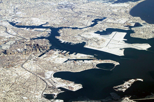
Boston in the snow. Image from reddit.

February 14th, 2013 | Permalink | {num}Comments
Tags: environment


Twitter


Site
About BeyondDC
Archive 2003-06
Contact

BeyondDC via XML RSS

Search:

GoogleBeyondDC
Category Tags:

Partners
 
  Greater Greater Washington
 
  Washington Post All Opinions Are Local Blog
 
  Denver Urbanism


Blogs about urban issues in and around Washington, DC

Urbanist blogs nation-wide

PLANetizen Top 50 Website 2003


BeyondDC v. 2013a | All rights reserved | 2003-2006 archive | Contact |