


A global cycling heat map from the fitness app Strava shows where people are exercising by bike. It’s a useful tool to chart the most popular bike trails, but the data skew heavily towards wealthier recreational cyclists and away from transportation and less affluent areas.
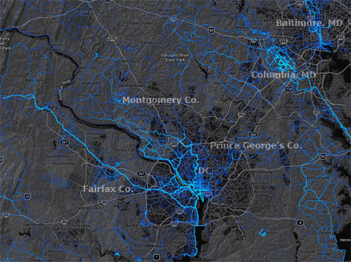
Stava cycling heat map for the DC region.
Strava is an exercise app for smartphones that uses GPS to track users’ cycling and jogging routes. Fitness enthusiasts use it to chart their running or cycling times, and measure performance over time. Since the company has billions of data points from users all over the world, it was easy to plot it all onto a map.
The resulting global heat map is a fascinating look at the most popular trails. For our region, it’s easy to see long-distance regional trails stand out, especially in Fairfax, Arlington, Montgomery, and Howard Counties.
But while this is interesting stuff, it’s unfortunately not very useful for urban transportation planning. Since 100% of Strava users care so much about speed that they’ve downloaded an app to measure it, and are wealthy enough to have a smartphone, the data skews seriously in favor of recreational cycling among affluent populations.
On the flip side, it seriously undercounts cyclists who bike as transportation simply to get from point A to point B. Likewise, it seriously undercounts lower income populations.
To prove the point, merely compare the trails on the west side of the DC region to those on the east side. Or compare the bright blue suburban trail network in Columbia, MD with the much more limited cycling apparent in central Baltimore. The places affluent people bike on the weekend stand out, while others sink to the background.
So this is neat info, beautifully presented, with practical applications to regional trail planning and parks planning. But for urban bike lanes, it’s no substitute for hard local data.
 Cross-posted at Greater Greater Washington.
May 12th, 2014 | Permalink
Tags: bike, maps, transportation


