


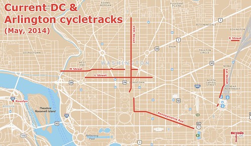
With DC’s M Street and 1st Street cycletracks on the ground, the central city network of protected bike lanes is starting to actually look like a network.
Base map from Google.
This map shows every cycletrack in town. In addition to M Street and 1st Street, there’s L Street, Pennsylvania Avenue, good old reliable 15th Street, and the diminutive R Street lane near the Metropolitan Branch Trail.
For the sake of completion the map also shows Rosslyn’s super tiny cycletrack, which exists mainly to access a popular Capital Bikeshare station.
Between DC’s proposed 70 mile cycltrack network and plans coming together in South Arlington, hopefully future iterations of this map will look even better.
Notice anything missing or wrong?
May 21st, 2014 | Permalink
Tags: bike, maps, transportation, Uncategorized


