


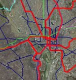
 Part of the Transit Vision as seen in Google Earth |
When we released the BeyondDC Transit Vision we included two maps showing our proposed transit system, an abstracted diagram and a true geographic map. Since then we’ve heard some readers have had trouble understanding where some of our proposed routes go, and that the geographic map is too hard to read at the scale provided and without labels.
In response, we’ve prepared a downloadable .kmz map. Download the file, open it in Google Earth, and then navigate in and out to your heart’s content.
A couple of notes:
September 29th, 2008 | Permalink
Tags: site, transportation


