


BeyondDC is in archive mode. Obviously.
You can continue to read my urbanist writing at ggwash.org/dan ❤️
Average Rating: 5 out of 5 based on 224 user reviews.
|
|
Blog
BeyondDC is in archive mode. Obviously. You can continue to read my urbanist writing at ggwash.org/dan ❤️ Average Rating: 5 out of 5 based on 224 user reviews.

Mayor Bowser's latest DC budget proposal includes $165 million to replace the Hopscotch Bridge. Once a new bridge is open, an eyesore will become a prime public space, and long-awaited expansions of Union Station and DC Streetcar can finally happen. Today, Hopscotch Bridge carries H Street over the railroad tracks behind Union Station. In order to make room for trains to pass below, the bridge rises high above H Street's normal elevation. With solid walls and the Union Station parking garage on either side, the bridge is a three block long stretch of desolation, amid an otherwise vibrant part of the city. Replacing the bridge will change that.
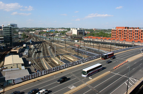 Existing Hopscotch Bridge. Image by Bossi licensed under Creative Commons. A new bridge, designed specifically to accommodate buildings on either side, will make it possible to develop the air rights above Union Station's railyard, and to replace the parking garage with a new train hall. What was desolate will become a major new public space, with landmark architecture, a mix of uses, and a more open, European-style train hall. That development is called Burnham Place. It's a very ambitious plan.
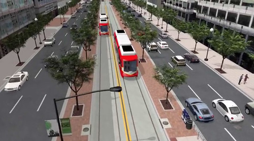
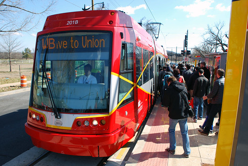
 Proposed H Street entrance to Union Station, as part of Burnham Place. Image by Akridge. Streetcar can go downtown Building a new Hopscotch Bridge also opens to door to finally extending the H Street Streetcar to downtown Washington and Georgetown. The streetcar doesn't specifically need a new bridge, but timing is an issue. DDOT doesn't want to extend the streetcar now only to rip up tracks and suspend service in a couple of years when the bridge is torn down and replaced anyway. As it is, tearing down and replacing the existing bridge will mean temporarily removing the streetcar stop atop the bridge. That's bad enough, but it would be a much worse situation with streetcars running downtown.
 When it runs downtown, DC Streetcar will have a dedicated transitway. Image by DDOT. Budget details Mayor Bowser's proposal would fund $165 million in 2019 and 2020. The DC Council will have to approve the budget before it becomes law. Even if it does, another $40 million would still be needed before construction could begin. That money would either come from other sources, or a future year's budget. Once funding is fully in place and DDOT completes the final design, construction should take about two years. Average Rating: 4.8 out of 5 based on 221 user reviews.
April 4th, 2017 | Permalink
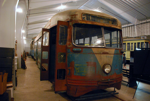
In the late 1950s and early '60s, as Washington's original streetcar system slowly converted its rail lines to buses, owners sold or gave away nearly 200 of DC's best railcars to any city that would take them. Those cars ran for decades all over the world. But time takes its toll, and today only one remains in anything like active service: Car #71 in Sarajevo, Bosnia and Herzegovina.
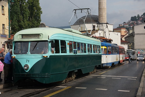 The last old DC Transit streetcar still in service, in Sarajevo. Image by Fototak on Flickr, used with permission. Sarajevo took a total of 71 PCC streetcars from DC between 1958 and 1962, running most of then until the late '70s. Fascinatingly Sarajevo's transit company combined some of the streetcars into longer articulated ones, and ran them as double units. They may have been the only PCC cars to ever become articulated. By the 1980s most of Sarajevo's DC railcars were retired. But one, car #71, has remained in service, sort of. It survived the brutal 1990s Siege of Sarajevo, and remains part of the tram fleet today, as a vintage model. It doesn't run every day, nor even most days. But it's still brought onto the streets to carry passengers during special events. It's the only remaining vintage DC streetcar that ever carries actual transit passengers. For the record, San Francisco's Market Street Railway has a car painted to look like an old DC streetcar, but beneath its paint the railcar itself ran in Minneapolis and New Jersey. What happened to the rest? Prior to the sell-off, DC Transit, the streetcar operator of the late '50s and early '60s, owned 450 railcars. Barcelona, Spain took 101 of them, and ran them until 1971. None of those remain in service, but four remain in museums or private collections. 15 of them went to America's only private subway system, the Tandy Center Subway in Fort Worth, Texas. Their new owners modernized the cars and ran them until the subway ended service in 2002. One of those 15 old streetcars went to the McKinney heritage streetcar line in Dallas where it ran until 2006, when mechanical and electrical problems forced it out of service. Three more of the Fort Worth railcars still exist. A group working to start a Texas transportation museum owns them, and hopes to use them as exhibits.
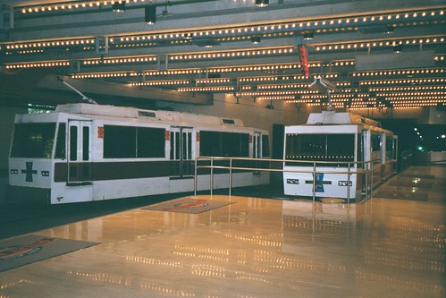 Former DC Transit streetcars running in the Tandy Center Subway in 2002. Image by Justin Smith on Flickr, licensed under Creative Commons. Thirteen other DC Transit streetcars remain in museums around the United States. The Smithsonian owns two, including one on public display at the American History museum. Seven remain at the National Capital Trolley Museum in Montgomery County. Three others there were lost in a fire in 2003.
 Former DC streetcar at the National Capital Trolley Museum. Four other railcars remain at museums in Virginia, Pennsylvania, Connecticut, and Maine. The other roughly 250 streetcars were scrapped and lost to history. Thanks to GGWash commenter Bob Shackleton, who tipped us off about Sarajevo. Average Rating: 5 out of 5 based on 265 user reviews.
March 9th, 2017 | Permalink
Happy birthday, DC Streetcar! Yesterday was the first anniversary of opening day. This year hasn't been perfect, but the streetcar steadily gained riders and has generally beaten expectations.
 According to monthly ridership reports, January 2017 was the streetcar's busiest month yet, in both total riders for the month and in average riders per weekday.
 January 21, the day of the Women's March, was the busiest single day since opening day itself, with 7, 347 riders. That was a Saturday, though, and obviously a unique event. The bigger story is how weekday ridership has grown over the year. For most of the streetcar's first six months open, more people rode on Saturdays than on any weekday. But as people have become familiar with the streetcar, it's evolved from curiousity to reliable fact of life. The number of people riding just to check it out has dropped, while those using it to commute has shot up. In January, for the first time, ridership passed above 3, 000 per weekday. At that level, the streetcar is performing at 236% of DDOT’s pre-opening estimate of 1, 300 daily riders. That's far below the roughly 14, 000 people who ride H Street buses every day, but it's not bad given the shortness of the line, and the trend is strongly positive.
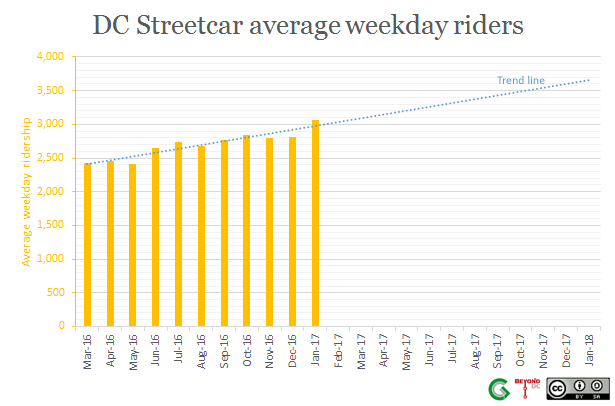 Far from perfect, but better than expectations The streetcar would still fare better with dedicated lanes, and the crossovers at 3rd Street and Starburst still slow most trips. Those problems absolutely exist. But they haven't derailed the entire operation. According to Martin DiCaro's WAMU story on the anniversary, the streetcar is marginally faster than the X2 thanks to fewer stops and faster loading, and is doing so well that DDOT is considering improving service to run every nine minutes. For a line that had the roughest of openings, it's been a surprisingly good year. Average Rating: 4.4 out of 5 based on 266 user reviews.
February 28th, 2017 | Permalink
DDOT's latest plan to redesign Florida Avenue shows a high quality protected bikeway between NoMa and West Virginia Avenue.
 Florida Avenue protected bikeway proposal. Image by DDOT. This new plan came as a surprise when DDOT presented it Tuesday night. Previous plans had only called for shorter unprotected bike lanes. But this stretch of Florida Avenue is the only practical connection for people riding bikes to NoMa Metro from the Trinidad neighborhood or much of DC's Near Northeast. Since collisions have been a problem here, and since the street is wider than the fast-moving car traffic on it warrants, a stronger bikeway makes sense. Details of the design The complete block-by-block plan is available online. It shows a two-way curb-protected bikeway on the south side of Florida Avenue, beginning at 3rd Street NE just east of the Red Line Metrorail tracks, and running east until 9th Street NE just shy of West Virginia Avenue. To reach West Virginia, the key connection into Trinidad and north into Ivy City, the bikeway jumps up onto the sidewalk for one block. DDOT will widen that sidewalk so it can accommodate people on both bikes and foot. From there, a two-stage bike box will help cyclists turn left onto West Virginia.
 Bikes will use the sidewalk and a two-stage bike box between 9th Street and West Virginia Avenue. Image by DDOT. East of West Virginia Avenue, Florida Avenue narrows significantly. DDOT isn't proposing to carry the bikeway into the narrower section. That stub ending has riled some community members, who've reached out to Ward 5 Councilmember Kenyan McDuffie to push for extending the bikeway all the way to Starburst intersection, where Florida Avenue ends. But extending the bike lanes east of West Virginia would likely mean either removing parking or making Florida Avenue one-way, both long-shot propositions. As of now, this plan is at the 30% design level, which means engineers have a basic design for the entire length of the project, but it's not yet precise enough to actually build. The full construction-level design will take another year to prepare; DDOT says to expect it in Spring of 2018. In the meantime, you can use the project website to learn more, and to leave comments. Average Rating: 4.8 out of 5 based on 202 user reviews.
February 23rd, 2017 | Permalink
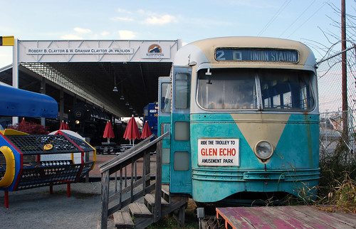
If you were an elementary school student the 1930s, this Dodge school bus might have been your ride. It carried students in Salem and Roanoke County, Virginia.
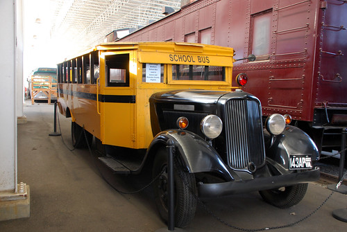 Check out the inside, with its child-sized benches and aisles. Who wouldn’t want to face the middle, or lean back against another kid?
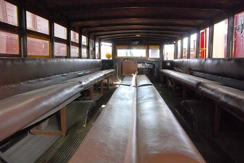 The bus is on display at the Virginia Museum of Transportation in Roanoke. The museum’s fascinating collection also includes this vintage 1945 streetcar from DC Transit. It ran on line 20, from Union Station to Glen Echo.
 Average Rating: 4.9 out of 5 based on 193 user reviews.
Almost every large city in the United States now has bikeshare. Any city without it should count itself way, way behind the curve. There are at least 119 systems nationwide, covering all but two of the 20 largest urban areas.
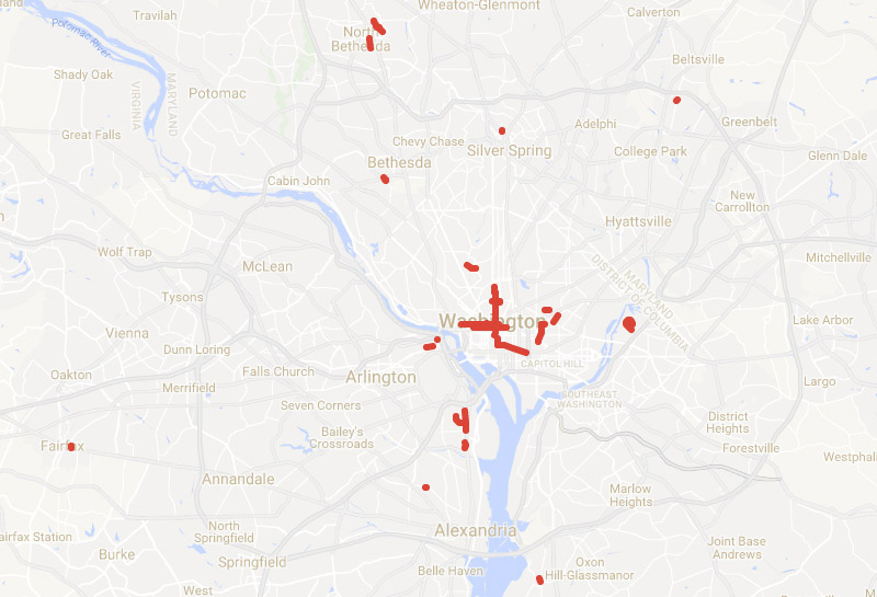
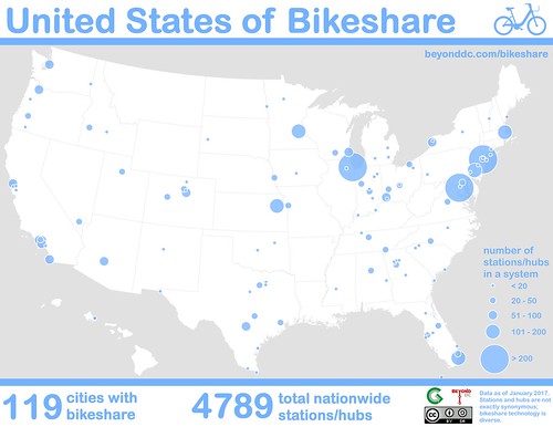 This map shows every bikeshare system in the country with at least two stations. The 119 nationwide systems together have about 4, 800 stations. The largest networks by far are in New York, Chicago, and Washington. A second tier is led by Minneapolis, Boston, and Miami. Of the 20 largest urban areas, only Saint Louis and Detroit still lack bikesharing. Unfortunately, Seattle’s Pronto will be the first major US bikeshare system to fail when it shuts down in March, adding a third. Here are the ten largest systems. Or see the complete list of all 119. Ten largest US bikeshare systems
There’s so much bikeshare, and its so diverse, that it’s hard to count It’s been less than 10 years since the first large-scale bikesharing systems debuted in the United States. In that time, bikes have spread like wildfire across the country. This list only includes networks with at least two stations, but bikesharing has become so ubiquitous that individual buildings now offer single-station systems. Even then, I’ve probably missed a few. It’s become virtually impossible to count them all. If you know of a missing system, mention it in the comments at GGWash. Furthermore, it’s hard to compare the systems on an apples-to-apples basis. The older and larger bikeshare systems rely solely on stations to dock bikes. But many newer systems don’t need docks, or have simple racks instead of docks that serve as hubs. Comparing “hubs” and “stations” can exaggerate the size of hub-based systems. That explains Topeka, which clocks in at number seven on the nationwide list with 138 hubs. But Topeka’s an unusual network; it actually has more hubs than bikes. With only about 100 actual bicycles, most of its hubs are usually empty. The network functions uniquely from any other in the country; even other hub-based systems don’t have that kind of ratio. Topeka’s urban area is about the same population as Frederick, Maryland, so its system is remarkable no matter what. But it’s not actually larger than Philadelphia’s. If Topeka were a station-based network, it would probably have around a dozen stations. The full 119-station list indicates hub-based systems with an asterisk, so you can spot them. Thanks to The Bike-sharing Blog for its excellent resources on worldwide bikeshare locations. Average Rating: 4.5 out of 5 based on 150 user reviews.
January 26th, 2017 | Permalink
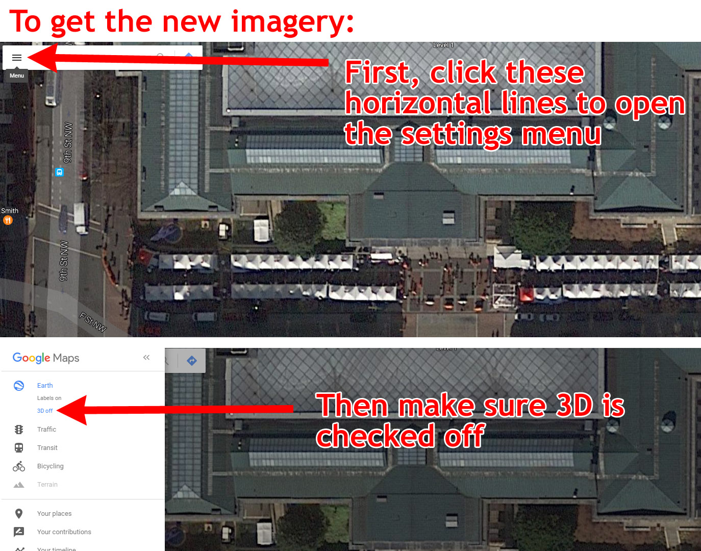
Google Maps now has brand new satellite images for the Washington region. The new photos, from December 19, 2016, show a cutting-edge view of our city.
 New images from December 19 show the Downtown Holiday Market in full swing. Image by Google. The new images only appear with certain settings. If you’re viewing in the default settings, you still get older photos. Here are instructions for how to change your browser settings to get the new imagery. Also, the new pictures only cover part of the region; imagery for the Dulles Airport Metro station, for example, is from April. Here are some highlights The Georgia Avenue bus lanes, in all their red glory:
 Image by Google. The National Museum of African American History and Culture:
 Image by Google. Construction at Capitol Crossing, atop I-395:
 Image by Google. Preparations for inauguration on Pennsylvania Avenue. And are those moving trucks on the White House driveway?
 Image by Google. MGM casino at National Harbor:
 Image by Google. Takoma-Langley Crossroads transit center:
 Image by Google. The Wharf, at the Southwest Waterfront:
 Image by Google. And finally, the hole where the Washington Post used to be:
 Image by Google. What else can you find that's new? Average Rating: 4.5 out of 5 based on 155 user reviews.
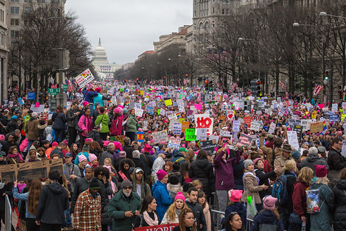
Here we are. Donald Trump is America's president. The largest protest in American history greeted his first day. Welcome to Washington and the USA in 2017. Our weekend was momentous Two days, two gigantic events. As inaugurations go, Friday's was noticably small. But even a small inauguration is big enough to change the tone of city life. Security fences partitioned blocks of downtown, and an army of police forces dominated the streets. Many locals stayed away to avoid the logistical and emotional headaches. Parts of the city became eerily dead, while others burst with unusual life, as Trump supporters descended to hotels and tourist areas around the White House. Washington became a foreign city, its own residents outsiders to a security and tourist project to which we didn't belong, nor feel healthy within.
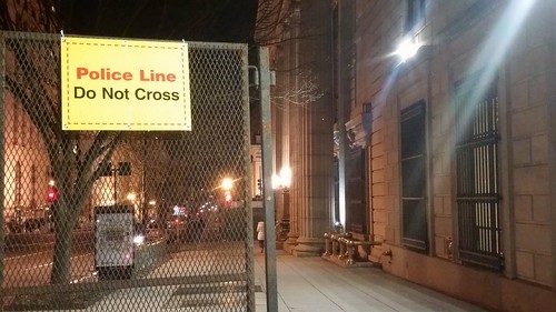 Security barriers in an empty downtown. During the inauguration itself, Metro ran smoothly. Trump presented a bleak picture of America. Protests raged, mostly peacefully, sometimes not. GGWash's own David Whitehead proved that deescalation works. The new administration erased climate change from presidential priorities, and disciplined the National Park Service for reporting meager crowds. Joe Biden took Acela home to Delaware. We went to bed, unsure the country we would wake to find. And then, on Saturday, three times more people attended the Women's March than Friday's inauguration. Nationwide, at least three million took to the streets. There was grief and humor and defiance. Mayor Bowser chanted "Leave us alone!, " DC police donned pink hats, and Metro had its second busiest day ever. In contrast to Friday, Saturday's Washington felt more ours than ever. The city became strangely joyous, as march-goers spread over downtown and the National Mall to reclaim our public spaces, replacing the inauguration's fenced-off security apparatus with revelry lasting well into the evening. We went to bed with renewed determination.
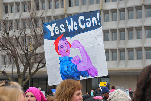 Image from Andrew Aliferis on Flickr. Meanwhile, Donald Trump's press secretary brazenly lied, and his counselor hoped to replace the truth with "alternative facts" intended to sow uncertainty and estrange the media. The policy fights are just beginning Trump may be the most urban president in history, but his party and his base are vehemently anti-urban. Administration policy seems to be largely under the purview of Vice President Pence, whose small town Indiana roots are decidedly not urban. They plan dramatic cuts to many federal departments, including the Department of Transportation, where multimodal infrastructure spending will likely decline in favor of tax breaks for construction firms. The Environmental Protection Agency is likely to be gutted, enabling a new round of urban pollution and ending the fight against climate change. HUD raised prices for first-time homebuyers within an hour of Trump's swearing-in. The Department of Justice will no longer pressure police departments over civil rights.
 What will the EPA look like in four years? Image from Paul Fagan on Flickr. Locally, such massive cuts and a proposal to strip benefits from government employees could throw Washington's economy into recession, as jobs bleed out of the city. Or security and military spending could lead to a new boom. Either way, Congress' small government Republicans will override local decision-making in DC. Nationally, the right is emboldened, while the left is beginning to act like a true opposition. So, here we are. Donald Trump is America's president. The future of our city and our country is uncertain. We face colossal challenges. But GGWash's mission and values are still worthwhile, and our community is as strong as ever. We'll be here. Average Rating: 4.6 out of 5 based on 228 user reviews.
January 23rd, 2017 | Permalink
As 2017 gets underway, there are at least 23 protected bikeways in the Washington region, totaling about 8.5 miles. This map shows them all.
 Protected bikeways in the Washington region. Or at least, all those I know about. There are so many now that it's becoming hard to keep track. The 23 bikeways range from lengthy to minuscule. DC's 15th Street cycletrack is both the oldest in the region and, at about 1.6 miles, the longest. On the other end of the spectrum are microscopic sections of normal unprotected bike lane where a few plastic bollards add a tiny degree of separation for a short stretch. The smallest is at the corner of New Hampshire Avenue and U Street, where a mere 60 feet of lane is protected with curb and flexposts. The District has by far the most mileage of protected bikeway, with about 7 miles and all of the five longest individual bike lanes. After DC, Arlington and Montgomery are in a virtual dead heat for second place, each hovering with almost exactly one mile of protected bikeway, spread across four separate locations in each county. Prince George's, Alexandria, and Fairfax City each have tiny cycletracks, combining for one-quarter mile. For the future, DC has grand plans for a vast cycletrack network, and more jurisdictions are beginning to work on their own. Expect this map to expand in coming years. In the meantime, if you know of an existing protected bikeway that's not on this map, leave a comment to let us know. Update: This post has been updated to reflect additional protected bikeway segments that were missing from the original map. Average Rating: 5 out of 5 based on 191 user reviews.
January 3rd, 2017 | Permalink
|
Media Tweets by @beyonddc
Follow @beyonddc
Site
Partners
|
||||||||||||||||||||||||||||||||||||||||||||||||||||||||||
|


