|
Special Features


Image Libraries


|
|
Blog
|
Northern Virginia needs more transit, but it doesn’t need half a dozen more of these. |
I like recently elected Congressman Gerry Connolly (D-VA). He understands the connection between transportation and land use and knows we can’t road-build our way out of congestion. He was fabulous as a Fairfax County Supervisor and I fully expect him to be fabulous as a Congressman.
But with all due respect to Mr. Connolly, he’s wrong about extending the Orange line from Vienna to Gainesville. We should absolutely have more transit in Northern Virginia, and in the DC-Fairfax-Manassas corridor specifically, but extending Metro along the median of I-66 would not be a good way to accomplish that.
Metrorail is the highest-capacity and most expensive kind of rail infrastructure available (short of mag-lev). This means governments should build Metrorail in places where that extremely high level of service is necessary. The sort of places that need such high level of service are urban downtowns, very dense inner city neighborhoods, and places where planners hope to create a downtown or a dense neighborhood. The median of an Interstate highway is none of those things, nor are far-out low density suburbs like Gainesville.
Now y’know, more transit is always good, so building a higher level than is necessary is OK (even desirable), except that we’re dealing with finite resources. Obviously if it were financially possible it would be ideal to have a 10, 000 mile-extensive mag-lev subway system operating under every major street in the region. Alas, since we have limited dollars, that isn’t possible.
Limited dollars are also why we shouldn’t be building Metrorail in a highway median to a low-density destination that will probably soon be served by other rail transit anyway. What should we do instead? How about THIS.
Instead of throwing billions of dollars into a single Metro line serving a single corridor that doesn’t need such high level of service to begin with, we should spend the same amount of money (or more, but either way) on improving regional rail and carpeting the whole region with streetcars/light rail. We could have this, which would be great but which we don’t really need, or we could have all this. For the same cost as it would take to extend the Orange line to Gainesville, we could extend VRE to Gainesville and drastically improve service frequencies on the entire VRE system and build a regional network of streetcars on several corridors around Northern Virginia.
Metrorail has been a glorious success and is worth every penny our region spends on it, but Washington area leaders need to understand that as magnificent as Metrorail is, it’s not the answer to every transit question that comes up. By matching the most appropriate transit mode to each corridor, we can spend our money more effectively and provide a higher level of transit service to a larger portion of our population covering a wider range of communities.
Average Rating: 4.5 out of 5 based on 161 user reviews.
March 13th, 2009 | Permalink
Tags: featured post, transportation

Now that the Silver line is a done deal and with yesterday’s post about renaming Metro stations fresh in mind, I want to give renewed attention to a point made back in 2008 about the proposed names of the Silver line stations in Tysons Corner:
Sooner or later we’re going to need names for these (stations) that people can use. Tysons East, Tysons Central 123, Tysons Central 7 and Tysons West are too cold. Who wants to be from a neighborhood named after a highway number, adjacent to another neighborhood named after a highway number? As suggestions, we’ll toss out (from east to west) Scott Run, Galleria Center, Westpark and Spring Hill.
The station names as currently proposed are horrid. They’ve been fine for planning purposes, but just won’t do for on-the-ground service. The good news is I recall hearing from one Fairfax County planner during an informal discussion that they may rename those stops (have a contest maybe?) but that nobody has made a decision. That was last year. With construction soon to begin, it’s time to decide for sure.
Update: Silver line representative Marcia McAllister clarifies: “Those decisions will be made by the Metro Board when the project is completed and transferred to them. The current station names are for design and construction.”
Average Rating: 4.9 out of 5 based on 211 user reviews.
March 11th, 2009 | Permalink
Tags: featured post, transportation
Approved and funded.
The Silver Line is a done deal. At 10:00 am this morning, right about as this post is being written, Transportation Secretary Ray LaHood is signing an official funding grant for $900 million. The first phase to Tysons Corner and Wiehle Avenue will open in 2013, and the remainder to Dulles Airport and Loudoun County in 2015.
More coverage at the Post and WTOP.
Woooooo!
Average Rating: 4.5 out of 5 based on 160 user reviews.
March 10th, 2009 | Permalink
Tags: featured post, transportation
According to Zach Schrag’s famous book about Metro history The Great Society Subway, the planners originally in charge of naming stations were told to keep it simple. In fact, says Schrag, the rule of thumb at the time was for no stations to be longer than two words. Obviously with names like U Street/African-American Civil War Memorial/Cardozo WMATA has moved away from that principle in recent years. These days many of the stations in the system are appended with some sort of slash-this or dash-something. Sometimes the change has made sense. The Federal government mandated that Reagan be added to National Airport, after all. A great many of the new names aren’t all that useful though; do we really need to know, for example, that students attending George Mason University sometimes use the Vienna station? GMU’s campus is over 5 miles from Vienna. The station does not directly serve the university. The name doesn’t have to be there.
At the same time, some stops could use a re-branding. When Dunn Loring opened it was envisioned as a park and ride serving commuters living in the Dunn Loring residential area north of the stop. The way things worked out most of the riders using the station are actually going or coming from the Merrifield commercial / industrial area south of the stop. The station originally called Dunn Loring would now be better named Merrifield.
It seems a good time to consider a look at the whole system. Thus the map below, illustrating a possible station renaming scheme. In some cases I renamed stations that are too long, or have too many acronyms attached at the end. In other cases I renamed to focus on a specific neighborhood or landmark. Where possible I’ve tried to stick to the two word maximum, but in a case or two have gone to three.
On the map gray station names are unchanged while black ones are those that have been modified.
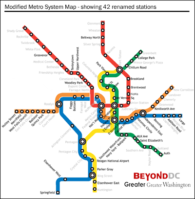
Have your own ideas? Share them in the comments.
Cross-posted to Greater Greater Washington.
Average Rating: 4.6 out of 5 based on 259 user reviews.
March 10th, 2009 | Permalink
Tags: featured post, transportation
|
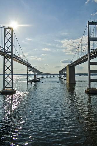
The two spans of the Chesapeake Bay Bridge |
In the summer months, Ocean City, Maryland swells from a sleepy town with a four-digit population to the state’s second largest city. At least 200, 000 visitors descend on it each summer weekend. The city spans well over 100 blocks north-to-south and boasts some of Maryland’s tallest buildings outside Baltimore. And Ocean City is just the largest of the Maryland-Delaware resorts.
And for the most part, everyone who goes to any of them drives, every time they go. So many people hit the road for OC each summer weekend that Maryland is considering adding a third span to the Chesapeake Bay Bridge.
Maybe that’s not the answer. If it were possible to get to Ocean City on transit, how many of those visitors would really need a car once there? Between the boardwalk tram and the Coastal Highway buses, it’s pretty easy to get around car-free. So given that DC-to-beach congestion is getting so bad, and given that Maryand is taking up the topic for study anyway, maybe it’s time to start thinking seriously about a Transitway To The Sea.
Such things are possible. New Jersey transit trains roll to the Jersey shore from both New York and Philadelphia, LIRR trains run to the Hamptons, Los Angeles is going to build a subway straight to Santa Monica, and just a few days ago I rode the N-Judah Muni Metro light rail line to one of San Francisco’s Pacific beaches. People use city-to-beach transit.
Unfortunately, the lack of existing rail tracks between DC and Annapolis or leading directly to Ocean City is a problem. Building a train from DC to the Atlantic would involve far more than just a new span across the Chesapeake. The money it would cost to lay new tracks would most likely be better spent on more urban projects that would serve riders year-round. But if a train is off the table, what about buses? In the BeyondDC Transit Vision the DC-Annapolis corridor was identified as ideal for BRT service. With the right bridge layout and the right investments to Route 50, Maryland might solve its holiday congestion problem (or at least give thousands the opportunity to bypass it).
Of course not everyone who crosses the Bay Bridge is going to Ocean City, nor even to Rehoboth or Bethany, but thousands and thousands of people are. Many of them are happy to ride intercity buses headed to New York, so why shouldn’t people ride a bus line to Ocean City?
Maryland should expand its study of a new span for the Bay Bridge to encompass summer holiday travel in a more general sense. If 200, 000 people are making essentially the exact same trip from the DC/Baltimore area to Ocean City every weekend in the summer, it would be far more economical, environmental and convenient to supply them with a quality transitway than expect every one of them to drive. Given that a new bridge would most likely be a billion dollar project, Maryland has a responsibility to at least consider other options.
Average Rating: 4.6 out of 5 based on 187 user reviews.
February 25th, 2009 | Permalink
Tags: featured post, transportation
|
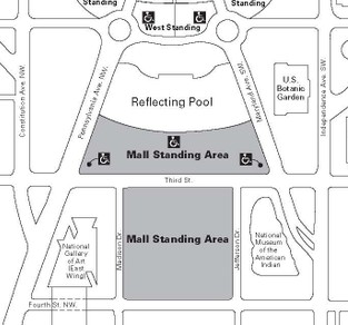
The Silver ticket area. |
There were definitely problems at Purple, and some reports are coming in that people were turned away from the Silver section. As far as I know, that is not true. I had Silver tickets and got in near the end. The section did NOT fill up. As a matter of fact, there was room at the back for at least another few thousand people. What happened, as near as I can tell, is that a lot of people with Silver tickets just turned out to be so impatient that it hurt them, and everyone around them.
The Silver section was split in half by Third Street (see map at right). If you had Silver, the entrance gate was at Third and Independence SW. Once through the gate you were supposed to get off Third Street and either go to the grassy area between Third and the Capitol reflecting pool, or go to the first section of the Mall between 3rd and 4th. The tickets, which everyone had, were very clear on this point.
What actually happened was thousands of people just stopped around Third Street and Maryland Avenue and watched from there, creating a huge bottleneck immediately inside the gate. As a result, the security people at the gate could only let people through very slowly, and in chunks. They’d let a hundred or so people through, then close the gate while those they let through forced their way back to the viewing area, through the people who had just decided to stop in the middle of the street just inside the gate. Then when there was room again, gate security would let another hundred or so through to repeat the process. Because the gate was moving slowly, and was sometimes shut for a few minutes at a time, rumor got spread around that it was closed for good, and a lot of people (believing rumor rather than any official announcement) turned around and left.
Thus some people decided the line at the gate was too long to risk, some ended up thinking the Silver gate was turning people away, and others who got through ended up thinking it was so overcrowded that you had to watch from just inside the gate at Third Street.
But anybody who waited patiently and followed the simple instructions printed on their ticket did just fine. The back of Silver (near Fourth Street) never got close to filling in completely.
Long story short: Silver probably should have been split into two sections with two different gates, but all the delays and problems were caused by folks who couldn’t follow simple instructions that they had access to well in advance. The folks who stopped at Third and Maryland (where they were not supposed to) gummed the whole thing up for everyone. The planning could have been better, but no plan will work if the public refuses to follow it. The blame for Silver’s poor performance lies with the people who stopped permanently just inside the gate, and with security for not moving them along.
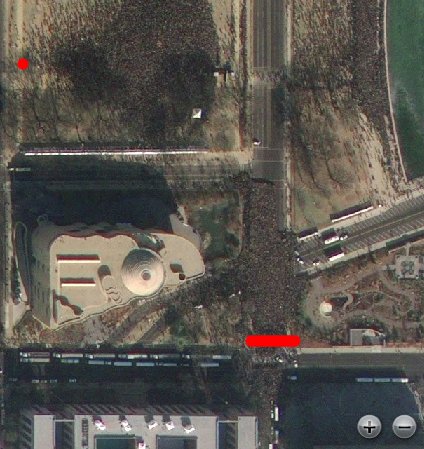
Update: This satellite image from GeoEye taken at 11:19 tells the whole story. To orient: the Capitol is off screen to the right, Independence Avenue is running along the bottom, Third Street runs from top to bottom, and the prominent building is the National Museum of the American Indian. The red line is the Silver gate. You can see a throng of people just inside it, and plenty of empty land beyond. The red dot is where I finally settled. For the high-res GeoEye image of the entire Mall, use WaPo’s viewer.
Average Rating: 4.7 out of 5 based on 232 user reviews.
January 21st, 2009 | Permalink
Tags: events, featured post, government
GGW has a post up making the case for Arlington’s Lee Highway corridor as the next Columbia Pike. GGW suggests the corridor could be transformed from a series of strip malls into a genuine urban boulevard, with a string-of-pearls of walkable neighborhood centers, connected by a streetcar.
It’s a great vision, and someday it will happen. It’s such a natural low-hanging fruit type of corridor that such redevelopment is probably inevitable. Arlington’s long range transit plan already identifies Lee Highway and Glebe Road as the most important transit corridors in the county without existing or planned rail service. In another decade or so, when the Columbia Pike and Potomac Yards transitways are finished, the county will probably turn its attention to Lee Highway.
But what about after that?
It’s long been assumed that the Route 50 corridor is hopeless. It’s too oriented for high-speed auto traffic and has no potential walkable nodes. It’s a car sewer, for better or worse.
But is it really? Living in nearby Ballston, we’ve often wondered what could be done with Route 50 if the possibility for radical change ever made it onto the table. If it were politically feasible to convert 50 from a highway into a surface street and use some of its width for a transit line, could neighborhoods be built around it? Could 50 become the new Wilson Boulevard?
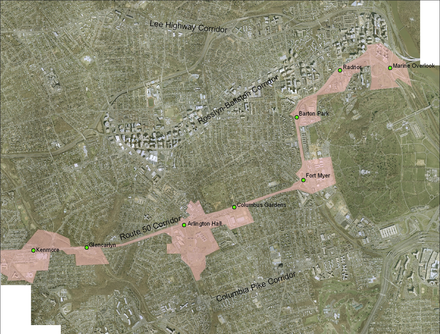
BeyondDC sat down at our computer and came up with the following plan. Pink is the Route 50 corridor, along with adjacent land that could be suitable for redevelopment. The green dots are potential transit stations.
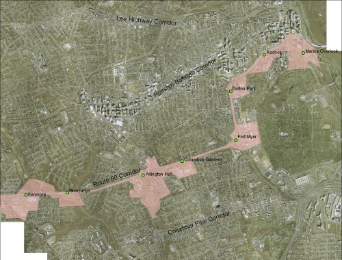
A possible Route 50 redevelopment plan for Arlington. Click to enlarge.
Surprisingly, there does seem to be room for a series of mixed-use, walkable neighborhoods along the corridor, in spaces that would leave the adjacent low-density neighborhoods in tact. It would be extremely difficult, of course. Not only would the roadway itself require an absolutely massive overhaul, but the Federal government would have to open up Fort Myer and Arlington Hall to development, which is unlikely to say the least.
So if it’s not exactly realistic to expect an urban Route 50 any time in the immediate future, it does at least seem physically possible. Maybe, when Columbia Pike and Lee Highway have met their potential, Route 50 can get some love.
We can only hope.
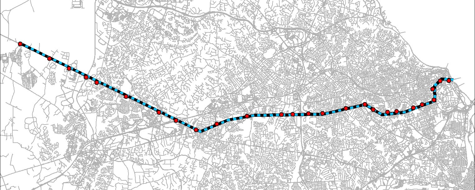
The route could be extended west, where the City of Fairfax is already talking about beefed-up transit and walkable nodes. Click the map to enlarge.
Update 12/31: To clarify, this isn’t anything that could be seriously proposed any time soon. It wouldn’t be appropriate (or feasible) for a “real” plan to suggest such drastic redevelopment on any near term time scale. The constraints are unreasonable to try to tackle while Columbia Pike and Lee Highway are still hanging out there. The point of this exercise isn’t so much to ask “should we do this now” as it is to ask “could we do this if we wanted to”. In 2008 there is no question: We don’t want to. But in 40 years when Route 29 and the Pike are nearing build-out in the manner that Rosslyn-Ballston is now, and when gas prices have had another couple of decades to creep up, it could be a place like Route 50 becomes obsolete and needs a plan like this.
Average Rating: 4.9 out of 5 based on 176 user reviews.
December 30th, 2008 | Permalink
Tags: featured post, master planning, transportation
|
Media


Site
About BeyondDC
Archive 2003-06
Contact
Category Tags:
Partners
|