|
Special Features


Image Libraries


|
|
Blog
Mayor Bowser's latest DC budget proposal includes $165 million to replace the Hopscotch Bridge. Once a new bridge is open, an eyesore will become a prime public space, and long-awaited expansions of Union Station and DC Streetcar can finally happen.

Rendering of the new Hopscotch Bridge, surrounded by new development behind Union Station. Image by Akridge.
Today, Hopscotch Bridge carries H Street over the railroad tracks behind Union Station. In order to make room for trains to pass below, the bridge rises high above H Street's normal elevation. With solid walls and the Union Station parking garage on either side, the bridge is a three block long stretch of desolation, amid an otherwise vibrant part of the city.
Replacing the bridge will change that.
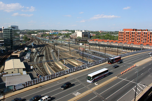
Existing Hopscotch Bridge. Image by Bossi licensed under Creative Commons.
A new bridge, designed specifically to accommodate buildings on either side, will make it possible to develop the air rights above Union Station's railyard, and to replace the parking garage with a new train hall. What was desolate will become a major new public space, with landmark architecture, a mix of uses, and a more open, European-style train hall.
That development is called Burnham Place. It's a very ambitious plan.

Proposed H Street entrance to Union Station, as part of Burnham Place. Image by Akridge.
Streetcar can go downtown
Building a new Hopscotch Bridge also opens to door to finally extending the H Street Streetcar to downtown Washington and Georgetown. The streetcar doesn't specifically need a new bridge, but timing is an issue. DDOT doesn't want to extend the streetcar now only to rip up tracks and suspend service in a couple of years when the bridge is torn down and replaced anyway.
As it is, tearing down and replacing the existing bridge will mean temporarily removing the streetcar stop atop the bridge. That's bad enough, but it would be a much worse situation with streetcars running downtown.
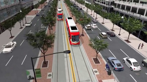
When it runs downtown, DC Streetcar will have a dedicated transitway. Image by DDOT.
Budget details
Mayor Bowser's proposal would fund $165 million in 2019 and 2020. The DC Council will have to approve the budget before it becomes law. Even if it does, another $40 million would still be needed before construction could begin. That money would either come from other sources, or a future year's budget.
Once funding is fully in place and DDOT completes the final design, construction should take about two years.
 Comment on this at the version cross-posted to Greater Greater Washington. Comment on this at the version cross-posted to Greater Greater Washington.
Average Rating: 4.8 out of 5 based on 243 user reviews.
April 4th, 2017 | Permalink
Tags: development, funding, government, master planning, roads/cars, streetcar, transportation

The St. Joseph’s Seminary in Northeast DCs’s Michigan Park neighborhood has a large eight-acre property, but the seminary only uses two acres. Rather than let the rest sit empty, they plan to add 90 new rowhouses on four acres, and turn the rest into a park.

The historic seminary building, as seen from 13th Street NE. Photo by Jonathan Neeley.
The Josephites, as the seminarians call themselves, have been working with developer EYA to build on the site. EYA’s proposal is called 12th and Allison. It focuses on the northern part of the site, preserving the southern part and its historic seminary building.

Location of St. Joseph’s Seminary. Image from EYA.
The Josephites would retain ownership of the southern part of the property, which includes both the building itself as well as a little over two acres of open space.
To the north, EYA would extend Webster Street through the block, connecting to 12th Street (Webster currently ends when it hits 13th, on the east side of the property). Surrounding the new Webster Street would be 90 rowhouses, most of them north of the new street.
Triplexes everywhere versus rowhouses and a park
Today the seminary grounds look sort of like a park. But they’re not. The seminary is private property, and if the Josephites sell part or all of it, that part can be developed according to however it’s zoned.
Almost all of Michigan Park is zoned R-2, which allows “semi-detached” housing like duplexes and triplexes. Many of the blocks surrounding the seminary are lined with the latter.
But developers rarely build triplexes these days. They require so many setbacks that it doesn’t pencil out to add in any communal open spaces like parks. But the setbacks are rarely large enough to be very good private yards. For new construction in the city, regular rowhouses are more popular with both sellers and buyers.
Thus, EYA hopes to rezone the property to R-5A, the same as Providence Hospital across the street. R-5A zoning would allow for normal rowhouses, which in turn could be clustered together, allowing for better community open spaces.
But rezoning requires city action, and that opens the door to controversy.
At a community meeting in October of last year, a number of residents made it clear that they were opposed to development of any kind. At least twice throughout the winter, opponents spread these flyers throughout the neighborhood, forewarning against the evils of building:

Opponent flyer. Photo by Jonathan Neeley.
Michigan Park is a cozy, moderate-density neighborhood. It’s fair for residents to wonder about the impact of a new development, and hope to influence it. But hyperbole like that isn’t helpful and isn’t true. Saying this project would “irrevocably damage our community” is a stretch.
90 new units on two big blocks won’t turn the place on its head. That’s only a little denser in total than the surrounding blocks of duplexes and triplexes.
By clustering the development mostly north of Webster Street and preserving more open space south of it, the northern block will be noticeably denser than triplexes, but in return the historic seminary building and much of the open space on the south will be permanently preserved, designated historic, and off-limits to future development.
That’s a good trade. Right now, if the Josephites wanted, they could sell their entire property and develop 100% of it as duplexes and triplexes by-right, whether anybody objected or not. Rather, in exchange for rezoning to allow rowhouses, the seminary and considerable open space will be saved.
Next steps
In April, EYA will present its latest plans at local ANC meetings. They’ve reduced the density of the proposal from 180 houses to 90, and promised to design the buildings in a high-quality, contextual way.
After that, they’ll submit for zoning approval, and apply to the District’s Historic Preservation Review Board to designate the seminary building as a landmark. Expect hearings on it this fall.
Comment on this at the version cross-posted to Greater Greater Washington.
Average Rating: 4.6 out of 5 based on 180 user reviews.
April 13th, 2016 | Permalink
Tags: development, land use, master planning, preservation
Rockville Pike could one day become a 252-foot-wide mega boulevard with 12 car lanes, 4 bike lanes, 2 bus lanes, and over 50 feet of landscaping. But in designing a street with more than ample room for cars, bikes, and buses, planners abandon any hope the street will be walkable.

The plan for Rockville Pike. Image from Rockville.
Everybody gets a lane!
Rockville Pike is one the most important retail strip highways in the Washington region. Like most 20th Century retail roads, it’s designed for cars, and it carries a lot of them.
Rockville wants to make it a more urban main street, so planners there are drawing up a redevelopment plan. It’s a laudable goal, and it’s not easy on a high-traffic state highway like Rockville Pike.
At first glance, this plan has all the components of a good complete street design: Tree-lined sidwalks, protected bikeways, a center-running dedicated busway. Every mode gets all the street width it could possibly want.
And why not? Why go through the political headache of forcing the community to make the difficult choice between fewer car lanes versus bikes or BRT if you can fit everything in? With a mega boulevard like this, everybody gets what they want, and nobody loses. Right?
Wrong.
Walkability loses, and it’s the most important factor
At 252 feet wide, the new Rockville Pike will be practically impossible for pedestrians to cross. It will take multiple traffic light cycles and multiple minutes for anyone to cross.
Instead of a main street, Rockville will have a barrier. And that is a big problem for the rest of the plan.
Transit oriented development doesn’t work unless it’s walkable. If Rockville Pike is too wide, development on one side of the street will be effectively cut-off from development on the other side. Riders won’t be able to easily access the BRT stations. People will drive for even short trips. The concept of a community where people don’t need to drive everywhere will break down.
If you can’t walk, other multimodal options don’t work. Pedestrians are the linchpin to the whole thing.
To be sure, some level of compromise is always needed. If walkability were the only factor that mattered, all streets would be pedestrian-only. We add in car lanes, bike lanes, and transit because we have to make longer trips possible, and that’s a good thing.
But there’s a balance, and 252 feet veers so far to accommodate long distance travel that it seriously sacrifices short distance walking. In so doing, Rockville undermines the very foundation on which its redevelopment plans rest.

Make pedestrians a priority
The Pike needs to be narrower. Assuming the sidewalks, busway, and three general car lanes each direction are sacrosanct, that still leaves a lot of potential fat to trim.
Are the service roads really necessary if the plan also includes new parallel local streets? Do we really need redundant bi-direction bikeways next to both sidewalks? Could we possibly reduce the 74 feet of various landscaping, buffer, and turn lanes?
These would be difficult trade-offs, to be sure. But there are massive negative consequences to an uncrossable mega boulevard.
If Rockville wants the new Pike to work as multimodal urban place, pedestrians need to become a priority.
Comment on this at the version cross-posted to Greater Greater Washington.
Average Rating: 4.6 out of 5 based on 205 user reviews.
March 24th, 2016 | Permalink
Tags: bike, BRT, master planning, roads/cars, transportation, urbandesign
A lot of people had awful commutes last night, thanks to snow. And a lot of people had fine ones. One explanation for the difference: Suburban roads are far more susceptible to catastrophic breakdown than urban street grids.
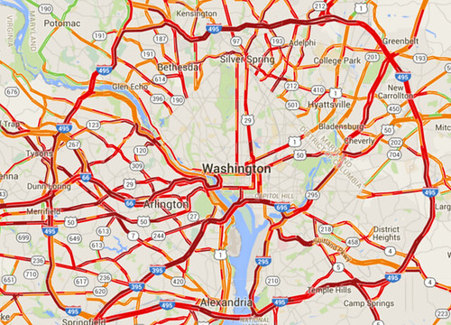
Traffic congestion on snow night. Image from Google.
Snow storms like last night’s highlight how easy it is to completely shut down suburban-style transportation systems. And conversely, how comparatively resilient are more urban systems.
Cities beat suburban areas on snow resiliency in two big ways: Multimodalism and network connectivity.
First and foremost, with transit, walking, and biking more convenient options, cities are simply much less reliant on having clear roads. Metrorail worked like a dream yesterday, and pedestrians had a lovely commute.
It simply didn’t matter how bad the roads got for a significant percentage of DC’s travelers, because they simply weren’t on the roads while they traveled.
Don’t put all your eggs in one basket
But that’s not all. Even for car drivers, urban street grids are more resilient than road systems focused around large highways, because of how they’re laid out.
The great thing about interconnected grids is that if one street becomes blocked, there’s another perfectly good street one block over. And another one block down.
If a wrecked car or fallen tree or whatever blocks the street you’re on, you just take a different street. There might be some additional turns involved; it might not be quite as direct. But for the most part 28th Street isn’t all the different from 29th Street.
Contrast that with suburban-style systems where all traffic in a particular area funnels onto one big highway. If that one highway becomes impassible, everyone in the area is stuck. Or, at best, they have to drive miles out of their way to find the next big highway.
This illustration shows how that works. If the “Collector Road” gets jammed, people in the top half of the image can still move around. People on the bottom half can’t.
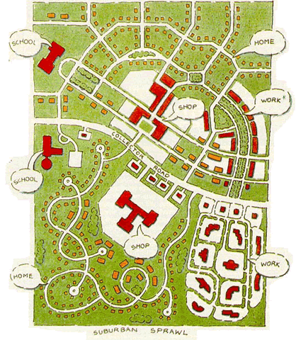
Suburban-style roads vs urban street grid. Image from USDOT.
That’s part of what happened last night. There were a lot of crashes. If they happened on arterial highways with no parallel roads, which a lot of them did, that road would succumb to gridlock.
Urban places aren’t immune, but they’re better off
To be sure, this storm was bad for roads all over the region.
Streets in Northwest DC were just as dangerous as those elsewhere, and DC’s plowing response was bad. And buses were every bit as stuck in it as cars.
But there’s no doubt that people who could travel via Metro or foot had a much better time, and there’s no doubt that drivers who could use parallel streets were able to bypass some of the congestion on arterials.
Comment on this at the version cross-posted to Greater Greater Washington.
Average Rating: 4.8 out of 5 based on 264 user reviews.
January 21st, 2016 | Permalink
Tags: environment, master planning, roads/cars, transportation
The redevelopment boom on H Street NE hasn’t yet transformed Hechinger Mall, the big suburban-style strip mall where H Street meets Bladensburg Road and Benning Road. But someday, when it inevitably does, there’s enough land for an entire neighborhood.
By superimposing a map of the Hechinger Mall area on top of other parts of DC, one can see just how great a change is on the horizon.

Hechninger Mall and surrounds by Dan Malouff using Mapfrappe and Google.
In the above image, the blue line outlines Hechinger Mall plus several surrounding properties with similar car-oriented retail. The mall and its surrounds beat as the commercial heart of multiple Northeast neighborhoods, including Trinidad, Carver-Langston, and Kingman Park.
It’s not unused land; there are plenty of stores, and they do robust business. But it’s definitely underused. Vast acres of parking sit mostly empty. Single suburban-style stores take up entire blocks. Internal streets look like highways, despite low traffic.
Someday it is going to redevelop. When that happens, it’s going to be as much a big deal as redevelopment in Columbia Heights or Union Market.
Compare the land
Let’s compare the amount of land we’re talking about.
Using a neat tool from Mapfrappe, it’s possible to superimpose that blue Hechinger Mall outline on top of other parts of DC, at the same scale.
Here’s Columbia Heights:

Columbia Heights comparison by Dan Malouff using Mapfrappe and Google.
As you can see, the blue Hechinger Mall outline is almost exactly the same size and shape of the center of Columbia Heights. You could almost pick up 14th Street and plop it down at Hechinger, and it would fit.
Now Union Market:

Union Market comparison by Dan Malouff using Mapfrappe and Google.
Again, it’s almost exactly the same size as the entire Union Market neighborhood.
Let’s keep going. NoMa next:

NoMa comparison by Dan Malouff using Mapfrappe and Google.
And now, City Center DC:

City Center comparison by Dan Malouff using Mapfrappe and Google.
NoMa is bigger. But Hechinger Mall is about the same size as the others. That’s the scale of redevelopment that could—that probably will—come to H Street.
And that’s great. There’s nothing wrong with the stores at Hechinger; DC needs shops like Safeway, Ross, and Dollar Tree. But DC also needs places to put more housing, and football field-sized parking lots a mile-and-a-half from the Capitol are exactly the right place.
Comment on this at the version cross-posted to Greater Greater Washington.
Average Rating: 5 out of 5 based on 152 user reviews.
December 1st, 2015 | Permalink
Tags: land use, master planning
As designs for the Corridor Cities Transitway BRT line solidify, officials are revising plans to try and cut costs and ease approvals. Among the changes: Smaller stations, fewer dedicated lanes, and fewer grade-separated street crossings.
 |
 |
| >Original two-bus station design (left) and smaller one-bus design (right). All images from Maryland. |
Smaller stations
According to initial designs, all transitway stations would have been 150 feet long, large enough to comfortably accommodate two articulated buses in each direction.
The revised plans reduce six of the transitway’s ten stations down to 65 feet long, and the other four stations down to 125 feet.
The 125-foot stations will still be able to squeeze in two buses at a time. The 65-foot stations will only fit a single bus. All stations will be designed so they can expand to 125 feet later if necessary.
With buses scheduled to come every six minutes at peak times, single-bus stations could cause delays if buses begin to bunch together.
Dedicated lanes at the Belward property
The Corridor Cities Transitway will be, for the most part, true BRT. It will have a dedicated running way for most of its length. But now officials are proposing that it run in mixed traffic for a 1.1 mile detour around the Belward property, aka the last farm in Gaithersburg.

Original alignment through the Belward property (left) and proposed mixed-traffic realignment around it (right).
This change isn’t to save money, nor is it to avoid upsetting car drivers. It has to do with the historic farmhouse in the middle of the property.
Under federal rules concerning historic preservation, the state cannot build the transitway through the farm unless the property is disturbed by development first. But Montgomery County’s master plan does not allow for development on the farm until after the transitway is up and running. It’s a chicken and egg problem.
Thus Maryland’s new plan: Buses will detour around Belward farm on existing roads, in mixed traffic.
It’s not clear whether the detour plan is supposed to be temporary or permanent. It could be the state will operate the detour at first, long enough to allow development at Belward, and then retrofit in the dedicated transitway once development is underway.
Or it could be the state will never correct this problem, and buses will run in mixed-traffic around Belward long after buildings have replaced the farm. Time will tell.
At-grade street crossing
Another major cost-saving change is coming where the transitway crosses MD Route 28, Key West Avenue.

Transitway crossing of Key West Avenue.
Initial plans called for an underpass below Key West Avenue. Buses never would have had to stop for a red light. New plans show a surface crossing, meaning buses will have to contend with traffic signals.
And although the state webpage does clearly say that an at-grade crossing will have minimal “effects on general traffic flow through the intersection, ” it doesn’t say anything about how this change will affect transit travel time.
Questions about cost
Montgomery County official Glenn Orlin recently revealed that costs for the transitway are climbing.
The most recent state cost estimate, from 2012, was for $545 million. Officially that’s still the estimate. But Orlin says a new estimate is forthcoming and will be “in the $700-800 million range.” If true, that’s a troubling increase, and could explain some of the state’s moves to reduce costs.
On the other hand, Orlin also indicated the new estimate is in year-of-construction dollars, while the old estimate was in 2012 dollars. If so, inflation could account for the lion’s share of the difference. Until the actual estimate comes out, it’s impossible to know.
It may not matter anyway, as the transitway remains unfunded, and prospects for funding under Maryland Governor Hogan appear slim.
Comment on this at the version cross-posted to Greater Greater Washington.
Average Rating: 4.5 out of 5 based on 286 user reviews.
July 14th, 2015 | Permalink
Tags: BRT, master planning, transportation
These stills from the four minute film Wanderers beautifully show what human civilization might look like with colonies on Mars, in the asteroid belt, and on the moons of Jupiter, Saturn, and Uranus.

Cities on Saturn’s moon Iapetus. All images from Erik Wernquist’s Wanderers.
Though stunning, these images are not mere fantasies. They’re based on real scientific ideas about what a spacegoing civilization would likely look like, given foreseeable future technology.
The film is by Swedish artist Erik Wernquist, who draws inspiration from hard sci-fi author Kim Stanley Robinson’s Red Mars trilogy, as well as his novel 2312.
The first image, above, shows a series of domed settlements on Saturn’s icy moon Iapetus. Iapetus has a giant equatorial ridge that runs around the entire moon like an actual physical equator. The views of ringed Saturn from atop Iapetus’ ridge would be among the most dazzling in the solar system.

Bird suit fliers on Titan.
This second image shows another moon of Saturn, Titan, where the human-powered transportation equivalent to bicycling would be a bird suit.
Titan is larger than the planet Mercury, has rivers and oceans of liquid methane, and an atmosphere thicker than Earth’s. Its combination of thick atmosphere and low gravity would make it possible for humans to fly using nothing but strapped-on wings.

“Terraruim” colony, from a hollowed cylindrical asteroid.
This third image shows an O’Neill cylinder colony, or what Wernquist and Robinson call a “terrarium.” It’s a cylindrical hollowed out asteroid that astronauts have filled with an atmosphere and terraformed with a habitable landscape.
That may seem like a lot of effort, but for a spacegoing civilization asteroids offer many advantages, especially for transportation purposes. Their extremely low gravity makes launches and landings much easier than any planet or moon, while they still have enough raw materials to mine and export.

Martian space elevator.
This last image shows a space elevator ferrying people and goods between orbit and a brightly lit metropolis on the surface of Mars.
Space elevators would have to be tens of thousands of miles long, but would negate the need for expensive chemical rockets, making space vastly easier and cheaper to access.
They’re exactly the sort of revolutionary transportation system that could completely change how humanity organizes itself. Prosperous port cities would be sure to form at the base of any elevators ever built, like futuristic New Yorks at the mouth of a celestial Hudson River.
Amazingly, space elevators are not that far-fetched. Scientists understand elevators’ physics well enough that they may be buildable within the next century.
Be sure to watch the four-minute film, and check out Wernquist’s gallery for more of these beautiful images.
Cross-posted at Greater Greater Washington.
Average Rating: 4.5 out of 5 based on 298 user reviews.
December 2nd, 2014 | Permalink
Tags: fun, master planning, proposal, transportation
Virginia Railway Express officials broke ground yesterday on the Potomac Shores station, an infill commuter rail station in Prince William County that will be the centerpiece of a new town center.
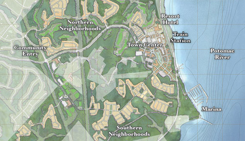
Potomac Shores site plan. Image from SunCal.
Potomac Shores is a gigantic development along Prince William’s Potomac riverfront, between Rippon and Quantico. It covers nearly 2, 000 acres and will eventually have over 3, 800 residential units.
The website boasts of “rugged beauty, ” an on-site 18-hole golf course, and miles of recreational trails. There’s no doubt that Potomac Shores is sprawl.
But it’s a new kind of sprawl. At its center, a new urbanist town center complete with a new commuter rail station.
Developer SunCal is building the station. When it opens in 2017, and if the town center has enough amenities, Potomac Shores could legitimately be a lot less car-dependent than the typical outer suburban subdivision.
That’s great news, even if it’s still true that Potomac Shores won’t be as urban, diverse, or dense as DC.
New urbanism marries TOD
For decades now, new urbanist communities have used mixed-use and good design to make for better suburbs. Nobody would call Kentlands a true city, for example, but it’s a marked improvement over most of west Gaithersburg. And since we’ll never fit all the growth in the entire metropolitan region into DC, getting suburbs right is hugely important.
By building around a VRE station, Potomac Shores takes 20th Century new urbanism to the next level. It’s not just a traditional neighborhood development; it’s a transit-oriented development.
There are other transit-oriented new urbanist communities popping up around the region. But they’re mostly in closer-in places like Montgomery County or Fairfax, and nobody has ever built a new VRE station as the centerpiece of one.
Potomac Shores is an experiment. It’s obviously sprawl, but maybe it’ll prove to be a more sustainable and livable kind of sprawl. Time will tell.
Cross-posted at Greater Greater Washington.
Average Rating: 4.4 out of 5 based on 260 user reviews.
August 5th, 2014 | Permalink
Tags: commuterrail, development, land use, master planning, transportation
The latest draft of DDOT’s citywide transportation plan, moveDC, calls for a massive expansion of transit and cycling facilities throughout the District, plus new tolls on car commuters. If the District adopts it, the plan will become one of America’s most progressive.

The moveDC plan summary map. All images from DDOT.
DDOT released the latest version of moveDC last Friday, launching a month long public comment period in anticipation of a DC Council hearing on June 27. Following that, the mayor will determine any changes based on the comment period, with final adoption anticipated this summer.
What’s in the plan
Amid the hundreds of specific recommendations in the plan, three major proposed initiatives stand out:
- A vastly improved transit network, with 69 miles of streetcars, transit lanes, and improved buses, plus a new Metrorail subway downtown.
- A massive increase in new cycling infrastructure, including the densest network of cycletracks this side of Europe.
- Congestion pricing for cars entering downtown, and traveling on some of DC’s biggest highways.
Transit

Proposed high-capacity transit network (both streetcars and bus). Blue is mixed-traffic, red is dedicated transit lanes.
The plan proposes to finish DC’s 22-mile streetcar system, then implement a further 47-mile high-capacity transit network that could use a combination of streetcars or buses. That includes 25 miles of dedicated transit lanes, including the much requested 16th Street bus lane.
Although the proposed high capacity transit corridors closely mirror the 37-mile streetcar network originally charted in 2010, there are several new corridors. In addition to 16th Street, moveDC shows routes on Wisconsin Avenue, both North and South Capitol Streets, H and I Streets downtown, and several tweaks and extensions to other corridors.
The plan endorses WMATA’s idea for a new loop subway through downtown DC, but explicitly denies that DC can fund that project alone.
MoveDC also shows a network of new high-frequency local bus routes, including Connecticut Avenue, Military Road, Alabama Avenue, and MacArthur Boulevard.
Bicycles
MoveDC also includes a huge expansion of trails and bike lanes, especially cycletracks.

Proposed bike network. The pink lines are cycletracks.
Under the plan, DC would have a whopping 72 miles of cycletracks crisscrossing all over the city. From South Dakota Avenue to Arizona Avenue to Mississippi Avenue, everybody gets a cycletrack.
Meanwhile, moveDC shows major new off-street trails along Massachusetts Avenue, New York Avenue, and the Anacostia Freeway, among others.
Tolls for cars
Congestion pricing is clearly on DDOT’s mind, with multiple proposals for new variable tolls in the plan.

Proposed downtown cordon charge zone.
The most aggressive proposal is to a declare a cordon charge to enter downtown in a car. This idea has worked in London and has been discussed in New York and San Francisco, but so far no American city has tried it.
Meanwhile, some of the major car routes into DC would also be converted to managed lanes. Like Maryland’s ICC or Virginia’s Beltway HOT lanes, managed lanes have variable tolls that rise or fall based on how busy a road is.
MoveDC proposes managed lanes on I-395, I-295, New York Avenue, and Canal Road.
What will the council think?
DDOT has produced a very strong plan, but is it going anywhere? The DC Council will discuss moveDC on June 27, at which time we’ll find out if the same people who pulled the rug out from under streetcar funding are interested in progressive policy-making, at least.
Even if DC does adopt this plan, whether the council will actually provide the funds necessary to build it is anybody’s guess.
Correction: An earlier version of this story reported the DC Council will approve or deny this plan. Authority to approve it actually rests solely with the mayor.
Cross-posted at Greater Greater Washington.
Average Rating: 4.5 out of 5 based on 261 user reviews.
June 2nd, 2014 | Permalink
Tags: bike, BRT, bus, government, lightrail, master planning, metrorail, roads/cars, streetcar, transportation
What do you get when you plot onto a single map every known light rail, streetcar, and BRT plan in the DC region? One heck of a huge transit network, is what.
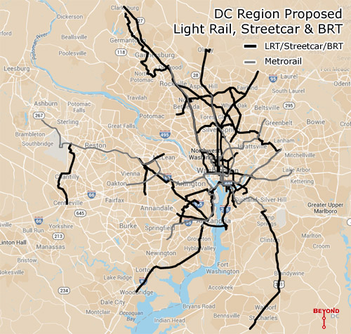
Every planned light rail, streetcar, and BRT line in the DC region. Click the map to open a zoom-able interactive version. Basemap from Google.
This map combines the DC streetcar and MoveDC bus lane plan with the Arlington streetcar plan, the Alexandria transitway plan, Montgomery’s BRT plan, and Fairfax’s transit network plan, plus the Purple Line, the Corridor Cities Transitway, the Long Bridge study, the Wilson Bridge transit corridor, and finally the Southern Maryland transit corridor.
Add the route mileage from all of them up and you get 267 miles of proposed awesomeness, not including the Silver Line or other possible Metrorail expansions.
To be sure, it will be decades before all of this is open to passengers, if ever.
The H Street Streetcar will be the first to open this year, god willing, with others like the Purple Line and Columbia Pike Streetcar hopefully coming before the end of the decade. But many of these are barely glimpses in planners’ eyes, vague lines on maps, years or decades away from even serious engineering, much less actual operation.
For example, Maryland planners have been talking about light rail extending south into Charles County since at least the late 1990s, but it’s no higher than 4th down on the state’s priority list for new transit, after the Purple Line, Corridor Cities Transitway, and Baltimore Red Line. Never mind how Montgomery’s expansive BRT network fits in.
Meanwhile in Virginia, the Gallows Road route seems to be a brand new idea. There’s yet to be even a feasibility study for it.
Even if governments in the DC region spend the next few decades building this network, there are sure to be changes between now and the day it’s all in place. Metro’s original planners didn’t know Tysons would become the behemoth it is, and contemporary planners can’t predict the future with 100% accuracy either.
Last year the Coalition for Smarter Growth published a report documenting every known route at that time, and already a lot has changed. More is sure to change over time.
Holes in the network
With a handful of exceptions these plans mostly come from individual jurisdictions. DC plans its streetcars, Montgomery County plans its BRT, and so on.
That kind of bottom-up planning is a great way to make sure land use and transit work together, but the downside is insular plans that leave gaps in the overall network.
Ideally there ought to be at least one connection between Fairfax and Montgomery, and Prince George’s ought to be as dense with lines as its neighbors.
But still, 267 miles is an awfully impressive network. Now let’s build it.
Cross-posted at Greater Greater Washington.
Average Rating: 4.5 out of 5 based on 260 user reviews.
May 6th, 2014 | Permalink
Tags: BRT, lightrail, maps, master planning, streetcar, transportation
|
Media


Site
About BeyondDC
Archive 2003-06
Contact
Category Tags:
Partners
|


