


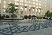
 Vermont Avenue’s new “road tattoo”. Photo by DDOT. |
Vermont Avenue between H and I Streets is an unusual place. It’s so underused as a traffic thoroughfare and such a prestigious location close to the White House that it is becoming clear it may be better suited to a life as something other than a mere street.
Not only is this block of Vermont the very last block of the street, it’s an orphan – a segment disconnected from the main stretch of the road, and therefore used very sparingly by drivers. So sparingly in fact that when it closes for a farmer’s market once a week at the height of rush hour there is no noticeable effect on congestion. Even when this block is open to traffic it is clear that there’s a surplus of available street space, given that it has pavement-hogging diagonal on-street parking, something typical in small towns but rarely available in more crowded big cities.
In fact, DDOT has even said it is considering closing the block more often for special events like concerts, in addition to the farmer’s market (link is a pdf – see bottom of page 1 under “Regulatory”).
On the other hand, Vermont’s orphan block is tucked so nicely between McPherson and Lafayette Squares that it almost feels like a park itself, especially when it’s closed for that rush hour farmer’s market. And as of this weekend, the city has installed a so-called road tattoo – an installation of pavement art that makes the space seem even less like a normal street and more a public plaza.
Given the situation, should this block even be a street? Would it make more sense to close it off and call it a park? Or maybe go halfway and continue to allow cars, but in a redesigned space? Or maybe this block is so valuable precisely because it’s a street rather than another park square, and we should leave well enough alone.
The great thing about the world of urbanist blogging is that we can ask these questions, and get an educated, insightful discussion going. So what do you think? Convert this block to a full-time park? Leave it a street but program things differently? Leave it be? If you think it ought to change, what’s the ideal solution?
 Cross-posted at Greater Greater Washington.
July 27th, 2010 | Permalink
Tags: proposal, urbandesign


