


Well, this is embarrassing.
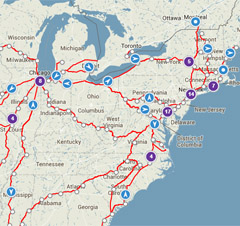
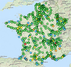
Using Amtrak’s real-time train tracker and the French equivalent, one can see the number of trains operating in each country at any given time. Putting them side-by-side isn’t a pretty sight.
 |
 |
It’s not quite as bad as it looks at first glance, because at this map scale Amtrak’s tracker clusters bunches of nearby trains into a single purple-colored dot. So there are admittedly a lot more trains in the Northeast and near Chicago than appear individually here.
On the other hand, Amtrak’s map shows all trains, while the French version is only showing regular speed ones. For high speed trains there’s a separate map.
Average Rating: 4.9 out of 5 based on 290 user reviews.
February 6th, 2014 | Permalink
Tags: intercity, maps, transportation


