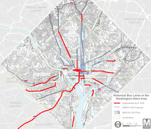
Prior to 1976 the DC region had at least 60 miles of bus-only lanes, with even more proposed. This map shows where they were.

On the map, the red lines show existing bus lanes as of 1976. Blue and black lines show proposals that never materialized. The network reached throughout DC, Northern Virginia, and into Maryland.
Unfortunately, all the bus lanes were converted to other purposes after the Metrorail system was built.
It’s no coincidence or surprise that some of the old bus lanes were on the same streets where they’re now proposed again, like 16th Street and H and I Streets downtown. Those are natural transit corridors, with great need for quality service.
Will we ever get this system back? The region is off to a good start, with moveDC’s 25 miles of proposed transit lanes, and the upcoming Crystal City Potomac Yard Transitway. But the 60-mile system from the 1970s shows we still have a lot of work to do.
 Cross-posted at Greater Greater Washington.
July 7th, 2014 | Permalink
Tags: BRT, bus, maps, transportation


