|
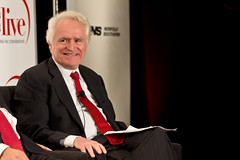
Richard Sarles. Photo by thisisbossi on Flickr. |
WMATA General Manager Richard Sarles announced at today’s Metro board meeting that he will retire, effective January, 2015.
The move comes as a surprise, since in 2013 Sarles agreed to a contract extension that would have kept him on the job until 2016. But not too much of a surprise: He’s 70 years old and has always said he didn’t intend to stay at WMATA long.
Sarles took charge of WMATA in 2010 and oversaw a significant rebuilding and safety-related overhaul of the transit system.
Metro board chairman Tom Downs says WMATA will conduct a nationwide search for Sarles’ replacement.
 Cross-posted at Greater Greater Washington.
Average Rating: 4.8 out of 5 based on 157 user reviews.
September 24th, 2014 | Permalink
Tags: government, metrorail, people, transportation
|
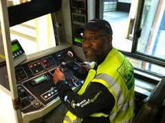
Photo by jnalexander on Flickr. |
Starting in early October, Metro will turn control of six non-peak Red Line trains over to computers. If all goes well, every Red Line train should be under computer control by March 2015.
This marks the first return to automatic train operation on Metro’s original system since WMATA switched all trains to manual control following the 2009 train crash.
Since then, WMATA has fixed the faulty electric systems responsible for the crash, but only on the Red Line. Fixing the rest of the system will take another three years.
When it works, automatic train operation runs Metrorail more efficiently and smoothly as compared to manual control. That means fewer delays, faster trips, higher passenger capacity, and more comfortable rides.
This is great news to riders who have suffered from motion sickness on manually-driven trains. And it’s an important step forward in Metro’s long, painful rebuilding process.
Cross-posted at Greater Greater Washington.
Average Rating: 4.5 out of 5 based on 298 user reviews.
September 22nd, 2014 | Permalink
Tags: metrorail, transportation
On Monday, Congress considered DC statehood. But what would DC actually look like if it became a state?
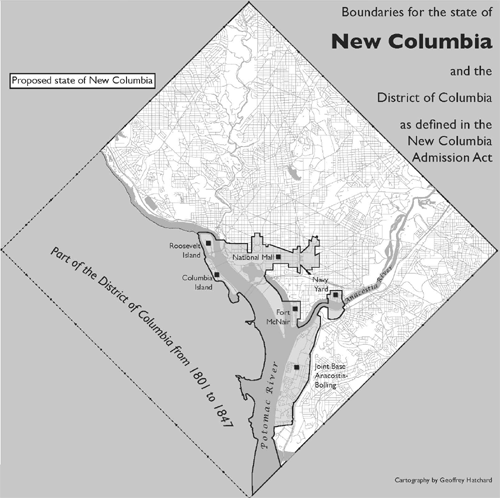
Maps by Geoffrey Hatchard for Neighbors United for Statehood.
The most likely path to statehood for the District would shrink the federal city to a tiny section surrounding the National Mall and other federal properties. That section would remain not part of any state. The rest of the city would then become the 51st state, possibly called New Columbia.
Here’s a zoom-in to what would become the remaining federal city.
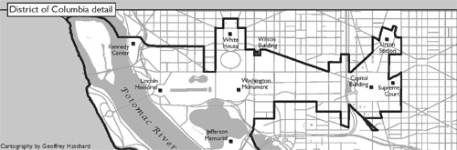
Cross-posted at Greater Greater Washington.
Average Rating: 5 out of 5 based on 210 user reviews.
September 17th, 2014 | Permalink
Tags: government, maps
Bus rapid transit will come to Richmond in 2018. The long-planned Broad Street BRT project won a federal TIGER grant this week to cover half its cost, allowing the project to move forward into final design and construction.
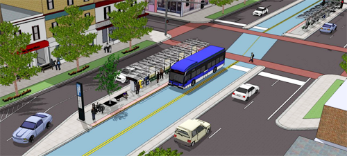
Rendering of Broad Street BRT. Image from the Greater Richmond Transit Company.
Broad Street is Richmond’s most successful transit corridor, and main bus spine. It runs through or near most of Richmond’s densest urban neighborhoods and most important central city hubs. It’s the natural place for rapid transit.
The BRT project will run from the Willow Lawn shopping center in suburban Henrico County, through Virginia Commonwealth University and downtown Richmond, all the way to Rocketts Landing on the city’s east side.
It will use a mix of dedicated curbside bus lanes and a median busway through the busiest sections of the central city, with mixed-traffic operation on either end.
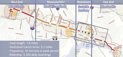
Map of Broad Street BRT. Original image from the GRTC.
Projections say the BRT line will carry about 3, 300 riders per day. That’s low compared to the standards of a transit rich metropolis like DC, but it’s huge for a place like Richmond, where there are only about 35, 000 total daily bus riders in the entire region.
Cross-posted at Greater Greater Washington.
Average Rating: 4.6 out of 5 based on 157 user reviews.
September 11th, 2014 | Permalink
Tags: BRT, bus, transportation
Earlier this year Columbus, Ohio launched CBUS, the Columbus Circulator. It’s a special overlay bus route running along the main street through the city’s densest, most urban neighborhoods. It comes every 10 minutes, has a low (actually free) fare, and limited stops. Sound familiar?
Oh, and here’s a photo:
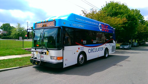
Photo by Darius Pinkston on Flickr.
Look familiar? That sweeping line, the destinations labeled on the side, “CIRCULATOR” in a modern sans-serif font right in the middle. It looks nothing like Columbus’ standard bus livery, but it is all very reminiscent of the DC Circulator.
In fact, Ohio transit advocates had the DC Circulator in mind during planning for CBUS.
Columbus isn’t alone, either. “Circulator” is spreading as an increasingly common brand choice for short-distance, high-frequency buses in mixed-use areas, especially near DC. There’s a Bethesda Circulator, a Tysons Circulator, and a Baltimore Circulator.
Just how far will this brand spread?
Cross-posted at Greater Greater Washington.
Average Rating: 4.4 out of 5 based on 291 user reviews.
September 10th, 2014 | Permalink
Tags: bus, transportation


