Special Features

Image Libraries

Blog

I was at last night’s awesome Nationals game. My upper deck first base side seats offered a great view of CityCenterDC rising.


Click for a larger version, then count the cranes.

If you’re interested, here are more pictures from the game.

Average Rating: 4.4 out of 5 based on 195 user reviews.

October 12th, 2012 | Permalink
Tags: development, fun


click to enlarge
Future Crown BRT station.

The long debated Crown Farm development in Gaithersburg officially begins construction today. The massive project will include 3, 750 residential units and 320, 000 square feet of retail, and is planned around a future station on the Corridor Cities Transitway. Impressively, it is Gaithersburg’s 5th large new urbanist neighborhood, with a 6th nearby in Rockville.

Unfortunately, construction of the transitway is still years away. But even without the transitway Crown Farm (now dubbed simply “Crown”) will be far superior to typical sprawl. And the transitway will eventually get there.

In the mean time, the first phases of the project will begin. The developers are holding off on the high rises that will be right next to the transit station until the transitway is at least closer to reality, but they’re starting phase 1 now. The plan below shows the various phases.

The pink (mixed use) and orange (residential) phases are what is beginning now. The transit station area, which will ultimately be the densest, will be in the purple phase.

For more images of the pink mixed use section, see JBG’s retail web page. Hat tip to Gaithersburg Patch for breaking the news.


Crown development phasing plan.

Update 1:13 pm 10.11.2012: Reader thisisbossi says construction started months ago. Gaithersburg Patch clarifies that today was the ceremonial groundbreaking.

Average Rating: 4.4 out of 5 based on 200 user reviews.

October 11th, 2012 | Permalink
Tags: BRT, development, transportation


The comment system BeyondDC uses is down. It will be a few days before I fix it. Sorry for any inconvenience.

Average Rating: 4.4 out of 5 based on 165 user reviews.

October 9th, 2012 | Permalink
Tags: site


click to enlarge
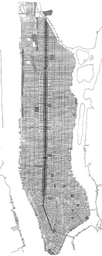
Flagg’s 1904 proposal. Image from Cornell University.

New York’s Central Park is probably the most famous urban park in America, but it might have been a very different place if a proposal in 1904 had been advanced.

Take a look at the image at right, which shows a Central Park redesign proposed by Ernest Flagg in 1904. The proposal maintains exactly the same amount of park land, but arranges it differently. It’s only 1/3 the width, but it’s 3 times as long.

The mere thought of changing Central Park so radically invokes gasps of disbelief and horror, but would this have been so bad? There would have been both positives and negatives.

Positives

One big problem with Central Park is that it’s only within walking distance of a small part of Manhattan. This redesign would have made park space more accessible to more people, by extending Central Park to be within walking distance of almost the entire island, except for the southern tip.

This Central Park might also have drawn more people to more active uses. The busiest and most-used sections of parks are usually near their edges, where they meet the city. Since this proposed redesign has more edges, it would have more edge activities, and might therefore draw more people. Imagine if Bryant Park or Washington Square Park went on for blocks.

This version of the park would also probably never have developed the night time crime problems that Central Park has sometimes had, also because of that edge effect. Or at least, crime in the park probably wouldn’t have been much worse than crime elsewhere in Manhattan. Since the entire park would always be visible from the street, criminals wouldn’t have so many places to lurk, and crimes would be more likely to be witnessed.

Negatives

The most obvious negative would be that a narrow Central Park could not offer any escape from the city. With the closest street never more than a block away, Manhattan would not have any public spaces that feel separate from the hustle and bustle. This park would be a much less natural-looking one.

Another big negative is that this park might have been destroyed during the road-building craze of the mid 20th Century, leaving Manhattan with nothing. It would have made the perfect location for a Robert Moses expressway, and even if Moses never got his hands on it, it’s still very easy to imagine such a long narrow space being re-purposed as an excessively wide avenue, like 9 de Julio Avenue in Buenos Aires. Nobody would argue that 9 de Julio is better than Central Park, but if the 1904 proposal went forward that might have been the result.

Overall, the temptation under this redesign to turn over park space for cars would have been even greater than in real life. It might have proven too much.

Thanks but no thanks

So at the end of the day, it’s probably a good thing that New York stuck with its original Central Park placement. There is a slim but legitimate chance that Flagg’s proposal might have turned out better, but the odds that it would have been worse are very strong. And in any event, New Yorkers would have lost their treasured natural escape.

Average Rating: 5 out of 5 based on 155 user reviews.

October 9th, 2012 | Permalink
Tags: urbandesign


Usually when it comes to dedicated street lanes for transit and bicycles, the more physical separation from car lanes there is, the better off you are. Better physical separation is why cycle tracks are better than regular bike lanes, and why busways are better than striped bus lanes.

Unfortunately, physical separation adds complexity and cost, so it’s not used as often as it might be.

That in mind, take a look at this picture from Guadalajara, Mexico, where a very affordable measure of physical separation has been added to a bus lane:


Photo by SoCalMetro on flickr.

This solution wouldn’t work in a lot of places for a lot of reasons, and even where it would work it isn’t as good as the expensive heavily-engineered options. But nevertheless it’s a cheap way to squeeze some separation into some bus lanes. It’s worth considering, wherever there isn’t a need for cars to cross over the bus lane, and where a more expensive solution isn’t practical.

The first cycle tracks in the US were heavily engineered and expensive, but we quickly learned that they needn’t be. Maybe it’s time to ask whether that same lesson can apply to busways.

Average Rating: 4.8 out of 5 based on 165 user reviews.

October 4th, 2012 | Permalink
Tags: BRT, bus, transportation, urbandesign


Grass track beds can make light rail systems a lot prettier, and so a lot of places use them. But check out this bit of creative thinking out of Houston, where they use water:


Main Street Square, Houston. Image by Google Street View.

Update: Apparently this doubles as a fountain. Here’s a picture with the water flowing. Hat tip to @FixWMATA.

Average Rating: 4.4 out of 5 based on 245 user reviews.

October 2nd, 2012 | Permalink
Tags: lightrail, transportation, urbandesign


click to enlarge
Buses at WMATA’s old Ballston bus yards, which has since been closed and redeveloped.

Here’s a simple fact of bus planning: You can only run as many buses during the day as you can park at night. Want to expand service but your bus parking lot is at capacity? Then sorry, too bad, can’t do it.

This simple issue drives bus operations as much as just about any other planning issue. Not only do you need big parking lots with maintenance garages attached, but they need to be geographically close to the bus routes they serve, because otherwise it costs too much to drive empty buses and drivers changing shifts back and forth from the parking depot to their routes.

In the transit supportive core of the Washington region, where bus ridership is booming and land is getting more and more expensive, the availability of bus parking is very probably the largest constraint on expansion of bus services. Multiple WMATA bus yards have been closed in recent years, claimed by high-density redevelopment near the baseball stadium and in Ballston.

So it’s a pretty big deal that last week WMATA opened a new bus storage yard, its first since 1989. The new Shepherd Parkway Metrobus Division is in Southwest DC and will house up to 250 buses, most of which will serve routes in SW and SE DC.

In the long term, improvements like this are the necessary ground work for the more interesting things that can happen later as a result, such as new bus routes, improved frequencies, and more high-capacity articulated buses. Good work, WMATA.

Average Rating: 4.4 out of 5 based on 265 user reviews.

October 1st, 2012 | Permalink
Tags: bus, development, transportation


Media


Site
About BeyondDC
Archive 2003-06
Contact

Search:

GoogleBeyondDC
Category Tags:

Partners
 
  Greater Greater Washington
 
  Washington Post All Opinions Are Local Blog
 
  Denver Urbanism
 
  Streetsblog Network


BeyondDC v. 2013d | Email | Archive of posts from 2003-2006