|
Special Features


Image Libraries


|
|
Blog
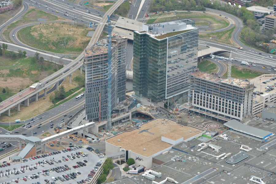
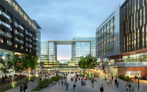
Mayor Bowser's latest DC budget proposal includes $165 million to replace the Hopscotch Bridge. Once a new bridge is open, an eyesore will become a prime public space, and long-awaited expansions of Union Station and DC Streetcar can finally happen.

Rendering of the new Hopscotch Bridge, surrounded by new development behind Union Station. Image by Akridge.
Today, Hopscotch Bridge carries H Street over the railroad tracks behind Union Station. In order to make room for trains to pass below, the bridge rises high above H Street's normal elevation. With solid walls and the Union Station parking garage on either side, the bridge is a three block long stretch of desolation, amid an otherwise vibrant part of the city.
Replacing the bridge will change that.
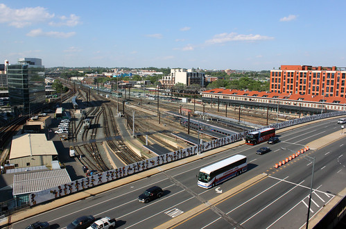
Existing Hopscotch Bridge. Image by Bossi licensed under Creative Commons.
A new bridge, designed specifically to accommodate buildings on either side, will make it possible to develop the air rights above Union Station's railyard, and to replace the parking garage with a new train hall. What was desolate will become a major new public space, with landmark architecture, a mix of uses, and a more open, European-style train hall.
That development is called Burnham Place. It's a very ambitious plan.

Proposed H Street entrance to Union Station, as part of Burnham Place. Image by Akridge.
Streetcar can go downtown
Building a new Hopscotch Bridge also opens to door to finally extending the H Street Streetcar to downtown Washington and Georgetown. The streetcar doesn't specifically need a new bridge, but timing is an issue. DDOT doesn't want to extend the streetcar now only to rip up tracks and suspend service in a couple of years when the bridge is torn down and replaced anyway.
As it is, tearing down and replacing the existing bridge will mean temporarily removing the streetcar stop atop the bridge. That's bad enough, but it would be a much worse situation with streetcars running downtown.
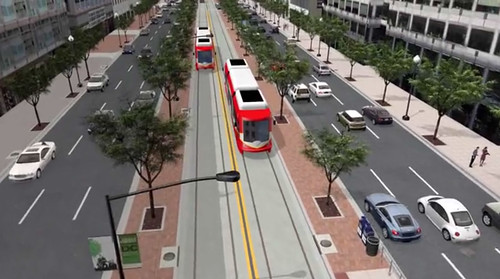
When it runs downtown, DC Streetcar will have a dedicated transitway. Image by DDOT.
Budget details
Mayor Bowser's proposal would fund $165 million in 2019 and 2020. The DC Council will have to approve the budget before it becomes law. Even if it does, another $40 million would still be needed before construction could begin. That money would either come from other sources, or a future year's budget.
Once funding is fully in place and DDOT completes the final design, construction should take about two years.
 Comment on this at the version cross-posted to Greater Greater Washington. Comment on this at the version cross-posted to Greater Greater Washington.
Average Rating: 4.4 out of 5 based on 173 user reviews.
April 4th, 2017 | Permalink
Tags: development, funding, government, master planning, roads/cars, streetcar, transportation

The St. Joseph’s Seminary in Northeast DCs’s Michigan Park neighborhood has a large eight-acre property, but the seminary only uses two acres. Rather than let the rest sit empty, they plan to add 90 new rowhouses on four acres, and turn the rest into a park.

The historic seminary building, as seen from 13th Street NE. Photo by Jonathan Neeley.
The Josephites, as the seminarians call themselves, have been working with developer EYA to build on the site. EYA’s proposal is called 12th and Allison. It focuses on the northern part of the site, preserving the southern part and its historic seminary building.

Location of St. Joseph’s Seminary. Image from EYA.
The Josephites would retain ownership of the southern part of the property, which includes both the building itself as well as a little over two acres of open space.
To the north, EYA would extend Webster Street through the block, connecting to 12th Street (Webster currently ends when it hits 13th, on the east side of the property). Surrounding the new Webster Street would be 90 rowhouses, most of them north of the new street.
Triplexes everywhere versus rowhouses and a park
Today the seminary grounds look sort of like a park. But they’re not. The seminary is private property, and if the Josephites sell part or all of it, that part can be developed according to however it’s zoned.
Almost all of Michigan Park is zoned R-2, which allows “semi-detached” housing like duplexes and triplexes. Many of the blocks surrounding the seminary are lined with the latter.
But developers rarely build triplexes these days. They require so many setbacks that it doesn’t pencil out to add in any communal open spaces like parks. But the setbacks are rarely large enough to be very good private yards. For new construction in the city, regular rowhouses are more popular with both sellers and buyers.
Thus, EYA hopes to rezone the property to R-5A, the same as Providence Hospital across the street. R-5A zoning would allow for normal rowhouses, which in turn could be clustered together, allowing for better community open spaces.
But rezoning requires city action, and that opens the door to controversy.
At a community meeting in October of last year, a number of residents made it clear that they were opposed to development of any kind. At least twice throughout the winter, opponents spread these flyers throughout the neighborhood, forewarning against the evils of building:

Opponent flyer. Photo by Jonathan Neeley.
Michigan Park is a cozy, moderate-density neighborhood. It’s fair for residents to wonder about the impact of a new development, and hope to influence it. But hyperbole like that isn’t helpful and isn’t true. Saying this project would “irrevocably damage our community” is a stretch.
90 new units on two big blocks won’t turn the place on its head. That’s only a little denser in total than the surrounding blocks of duplexes and triplexes.
By clustering the development mostly north of Webster Street and preserving more open space south of it, the northern block will be noticeably denser than triplexes, but in return the historic seminary building and much of the open space on the south will be permanently preserved, designated historic, and off-limits to future development.
That’s a good trade. Right now, if the Josephites wanted, they could sell their entire property and develop 100% of it as duplexes and triplexes by-right, whether anybody objected or not. Rather, in exchange for rezoning to allow rowhouses, the seminary and considerable open space will be saved.
Next steps
In April, EYA will present its latest plans at local ANC meetings. They’ve reduced the density of the proposal from 180 houses to 90, and promised to design the buildings in a high-quality, contextual way.
After that, they’ll submit for zoning approval, and apply to the District’s Historic Preservation Review Board to designate the seminary building as a landmark. Expect hearings on it this fall.
Comment on this at the version cross-posted to Greater Greater Washington.
Average Rating: 4.5 out of 5 based on 254 user reviews.
April 13th, 2016 | Permalink
Tags: development, land use, master planning, preservation
According to the California housing champion who’s suing communities that don’t allow enough new development, not building needed density is morally equivalent to tearing down people’s houses.
Photo by .Martin. on Flickr.
Sonja Trauss, founder of the SF Bay Area Renters’ Federation sums up the housing problem affecting nearly every growing American city today:
“Most people would be very uncomfortable tearing down 315 houses. But they don’t have a similar objection to never building them in the first place, even though I feel they’re morally equivalent. Those people show up anyway. They get born anyway. They get a job in the area anyway. What do they do? They live in an overcrowded situation, they pay too much rent, they have a commute that’s too long. Or maybe they outbid someone else, and someone else is displaced.”
Trauss hits the key points: The population is growing, and people have to live somewhere. If we refuse to allow them a place to live, that’s just like tearing down someone’s home.
Someone else is displaced
Trauss’ last sentence is particularly important. It explains how the victims of inadequate housing often are not even part of the discussion. She says “Or maybe [home buyers] outbid someone else, and someone else is displaced.”
Here’s how that works: One common argument among anti-development activists is that new development only benefits the wealthy people who can afford new homes. That’s wrong. It’s never the wealthy who are squeezed out by a lack of housing. Affluent people have options; they simply spend their money on the next best thing. Whenever there’s not enough of anything to meet demand, it’s the bottom of the market that ultimately loses out.
Stopping or reducing the density of any individual development doesn’t stop displacement or gentrification. It merely moves it, forcing some other person to live with its consequences.
Every time anti-development activists in Dupont or Georgetown or Capitol Hill reduce the density of a construction project, they take away a less-affluent person’s home East of the River, or in Maryland, or somewhere else. The wealthy person who would have lived in Capitol Hill instead moves to Kingman Park, the middle class person who would have lived in that Kingman Park home instead moves to Carver Langston, and the long-time renter in Carver Langston gets screwed.
As long as the population is growing, the only ultimate region-wide solution is to enact laws that allow enough development to accommodate demand.
Comment on this at the version cross-posted to Greater Greater Washington.
Average Rating: 4.9 out of 5 based on 185 user reviews.
January 5th, 2016 | Permalink
Tags: development, economy, environment, law, preservation
While H Street NE has boomed in recent years, nearby Benning Road has lagged. That’s about to change, with at least two big Benning Road redevelopments coming down the pipeline.

The proposal at 17th and Benning. Image from Capital City Real Estate.
Benning Road NE is, for all intents and purposes, an easterly extension of H Street. East of Starburst the name changes, but Benning more or less functions as the same road, streetcar and all. Except that while H Street has undergone a dramatic transformation in recent years, Benning Road has not.
But now it appears the H Street boom is jumping to Benning.
On December 17, developers officially filed plans to build a 180-unit multifamily building at the northeast corner of Benning Road and 17th Street NE, across 17th Street from Hechinger Mall.
It’s the first big, H Street-style proposal to see the light of day on Benning Road.
But it’s not the only one. Half a block away and across the street, near 16th and Benning, another developer is proposing a 250-unit building. There are no renderings yet, but rumor purports it will be similar to The Maryland at Maryland Avenue and 14th Street NE.
Together, these developments show how the impending Benning Road boom isn’t a matter of if, it’s a matter of when. Properties along Benning are too enticing, demand for new housing in DC is too ravenous, and the streetcar, for all its faults, is too much of a draw. Benning is about to boom, and it won’t be the same.
Comment on this at the version cross-posted to Greater Greater Washington.
Average Rating: 4.4 out of 5 based on 258 user reviews.
December 23rd, 2015 | Permalink
Tags: development
A miniature Target is now open in Rosslyn, occupying the ground floor of an office tower. At less than a sixth the size of a typical suburban Target, it shows how retailers are adapting to America’s increasingly urban reality.

Inside Rosslyn’s Target.
The store had a soft opening last week, and an official opening Sunday. At 23, 000 square feet, it’s about the size of a large Trader Joe’s, or a small Safeway. It’s minuscule compared to normal Target stores, which often top 150, 000 square feet.
And yet, it’s got a little of everything, just like a normal Target.

Inside Rosslyn’s Target.
A few years ago, when I lived in a Ballston high rise, I’d have killed to have a Target on the Orange Line. The only department stores I had easy access to were the Macy’s in Ballston and downtown DC. And, for a recent college grad spending way too much on housing, Macy’s wasn’t in my budget for housewares.
Now urban department stores are sprouting everywhere.

Rosslyn’s Target, from Wilson Boulevard.
This is, by my count, at least the Washington region’s fourth fifth urban-format Target. The first opened in the 1990s in Gaithersburg. Then came Columbia Heights in 2008 and Merrifield in 2012, then our first mini Target earlier this year in College Park.
Walmart joined the game beginning in late 2013, with urban stores downtown and on Georgia Avenue.
Smaller stores may be the new normal
It’s not just Target and Walmart looking to get in on this game. Other chains are launching a new breed of mid-size stores, like this mini Target, in a race to fill the urban retail niche.
In 2013, Walgreens opened a new “flagship” store in Chinatown. At 23, 000 square feet, it’s almost exactly the same size as the new Rosslyn Target, and twice a normal Walgreens.

The flagship Walgreens. Photo from Google.
And although their merchandise selections are a little different (the Target has more clothes and housewares, while the Walgreens has more beauty & health products), the Rosslyn Target and the Chinatown Walgreens are clearly evolving towards becoming a similar category of store: The not-quite-department-store, or the 21st Century general store.
Whatever you call it, it’s a growing retail niche.
Comment on this at the version cross-posted to Greater Greater Washington.
Average Rating: 4.5 out of 5 based on 207 user reviews.
October 12th, 2015 | Permalink
Tags: development, economy, The New America
DC’s population is rising overall. But amid that rise, hundreds of thousands of people have come or gone since the year 2000. Among those who have left, inadequate housing is by far the biggest single reason.
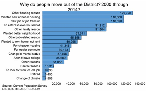
Image from the DC Office of Revenue Analysis.
According to survey data summarized in this report from the DC Office of Revenue Analysis, 937, 115 people have moved out of DC since the year 2000. 36% of them, 338, 000, cite a housing-related category as the reason why.
Some respondents say directly they needed cheaper housing. Others say they wanted newer housing, or better housing, or to own instead of rent. But the common denominator is that DC’s housing stock is inadequate, and that inadequacy is stifling the District’s population growth, as thousands who’d otherwise prefer to stay move away.
Every time some government agency restricts the housing market’s ability to meet DC’s tremendous demand, they make this problem worse. Every time the zoning commission downzones rowhouse neighborhoods, or every time a review board lowers a proposed building’s height, DC’s housing market becomes a little bit worse than necessary.
Over time as each restriction builds on the last, competition for the limited housing that’s available rises, prices shoot up, and the city’s less affluent populations are squeezed out.
It’s true that DC can never be all things to all people. For example, DC will never be able to supply as many large lot subdivisions as upper Montgomery County. But many types of housing that DC can absolutely supply are being unnaturally and unnecessarily restricted.
It’s a horrible situation.
What about schools?
DC’s inadequate schools are without a doubt also a major reason some people leave the District. According to Yesim Sayin Taylor of the Office of Revenue Analysis, we don’t know how many residents have left because of schools because the survey, which wasn’t designed specifically for DC, didn’t ask that question.
Presumably respondents who left because of schools cited something more general like “other family reason” or “wanted better neighborhood.”
Cross-posted at Greater Greater Washington.
Average Rating: 4.9 out of 5 based on 296 user reviews.
June 12th, 2015 | Permalink
Tags: demographics, development, economy, government, law, preservation
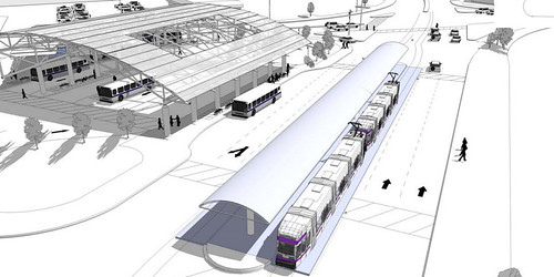
Construction is progressing rapidly at Maryland’s Takoma Langley transit center. Take a look:
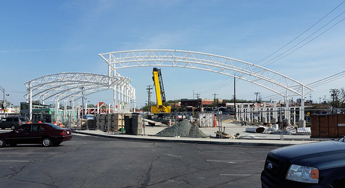
Construction progress as of Saturday, April 18, 2015.
The transit center will feature bus bays and rider amenities, covered under a great curving roof that’s sure to become a local landmark.
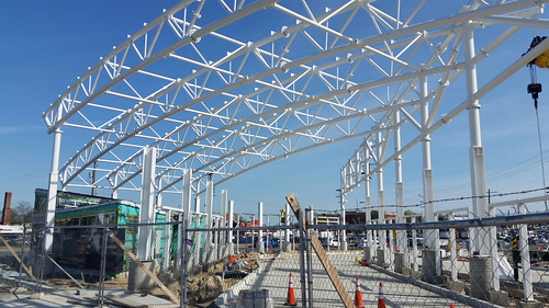
Fow now, the bright white frame looks more like something out of a sci-fi movie than a bus station.

Here’s what it will all look like once construction is done:
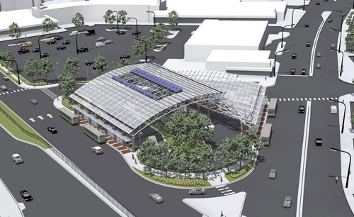
Rendering of the final station. Image from the State of Maryland.
Langley Park needs this
Langley Park, at the corner of University Boulevard and New Hampshire Avenue, is the busiest bus transfer location in the Washington region that isn’t connected to a Metro station.
Eleven bus routes stop on the side of the street at the busy crossroads, serving 12, 000 daily bus riders. That’s nearly as many bus riders per day as there are Metrorail riders at Silver Spring Metro, and it’s about double the number of Metrorail riders at Takoma station.
Corralling all those bus stops into a single transit center will make transfers vastly easier, faster, and safer for bus riders.
Heavy construction began at the transit center last year, and is scheduled to be complete around December 2015.
If the Purple Line light rail is built, Takoma Langley will become one of its stations, boosting ridership even more. The light rail transitway and station would have to be added later, and would fit snuggly in the median of University Boulevard.
How a Purple Line station would fit. Rendering from the State of Maryland.
Cross-posted at Greater Greater Washington.
Average Rating: 4.8 out of 5 based on 273 user reviews.
April 22nd, 2015 | Permalink
Tags: bus, development, lightrail, transportation
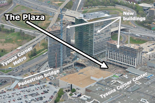
Metro’s Silver Line isn’t the only indication the transformation of Tysons Corner is clearly underway. Further undeniable evidence: The Plaza, a popular new urban-style open space at the front door to Tysons Corner Center mall.
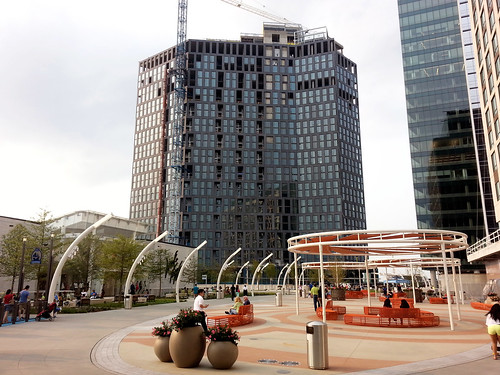
The Plaza (that’s its official name) is on the north side of the mall, near the pedestrian bridge from the Tysons Corner Metro station. Three new high-rises are under construction around the plaza, tightly enclosing the space like a genuine city square.
The Plaza and its surroundings. Original photo from Macerich.
The pedestrian bridge to the Metro station isn’t open yet, because the high-rise it connects is still under construction. But when all is said and done, The Plaza will become the main entry point to the mall from the Metro. In a very real sense it will become the center of this emerging urban neighborhood.
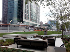
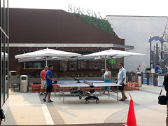
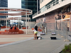
Befitting Tysons, The Plaza is a thoroughly contemporary update on the classic city square. There’s no marble statue in the middle, no grand fountain like in Dupont Circle. Instead, there are padded couches, small-scale artistic flourishes, and outdoor games.
 |
 |
| Couches (left), and sculpted birds (right). |
 |
 |
| Ping pong (left) and corn hole (right). |
The first plaza-fronting retail, a Shake Shack, opened earlier this week. More is coming soon.
One crucial difference between The Plaza and a traditional city square is who owns it. This may masquerade as civic space, but it’s clearly private property. Security guards patrol the square, and you can bet homeless people aren’t welcome to sleep on benches.
But still, The Plaza is a big step forward for Tysons. It’s a genuine gathering place, and people are using it. Even without the Metro connection, plenty of other people were hanging out nearby when I visited last weekend. It’s not the kind of place that a mere 20th Century office park would support.
Cross-posted at Greater Greater Washington.
Average Rating: 4.8 out of 5 based on 254 user reviews.
August 14th, 2014 | Permalink
Tags: development, fun, parks, urbandesign
Virginia Railway Express officials broke ground yesterday on the Potomac Shores station, an infill commuter rail station in Prince William County that will be the centerpiece of a new town center.
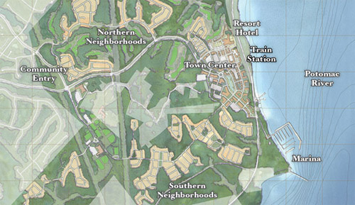
Potomac Shores site plan. Image from SunCal.
Potomac Shores is a gigantic development along Prince William’s Potomac riverfront, between Rippon and Quantico. It covers nearly 2, 000 acres and will eventually have over 3, 800 residential units.
The website boasts of “rugged beauty, ” an on-site 18-hole golf course, and miles of recreational trails. There’s no doubt that Potomac Shores is sprawl.
But it’s a new kind of sprawl. At its center, a new urbanist town center complete with a new commuter rail station.
Developer SunCal is building the station. When it opens in 2017, and if the town center has enough amenities, Potomac Shores could legitimately be a lot less car-dependent than the typical outer suburban subdivision.
That’s great news, even if it’s still true that Potomac Shores won’t be as urban, diverse, or dense as DC.
New urbanism marries TOD
For decades now, new urbanist communities have used mixed-use and good design to make for better suburbs. Nobody would call Kentlands a true city, for example, but it’s a marked improvement over most of west Gaithersburg. And since we’ll never fit all the growth in the entire metropolitan region into DC, getting suburbs right is hugely important.
By building around a VRE station, Potomac Shores takes 20th Century new urbanism to the next level. It’s not just a traditional neighborhood development; it’s a transit-oriented development.
There are other transit-oriented new urbanist communities popping up around the region. But they’re mostly in closer-in places like Montgomery County or Fairfax, and nobody has ever built a new VRE station as the centerpiece of one.
Potomac Shores is an experiment. It’s obviously sprawl, but maybe it’ll prove to be a more sustainable and livable kind of sprawl. Time will tell.
Cross-posted at Greater Greater Washington.
Average Rating: 4.8 out of 5 based on 299 user reviews.
August 5th, 2014 | Permalink
Tags: commuterrail, development, land use, master planning, transportation
The FBI is considering moving its headquarters from downtown Washington to either Greenbelt, Landover, or Springfield. If they pick Greenbelt, here’s what the development will look like:
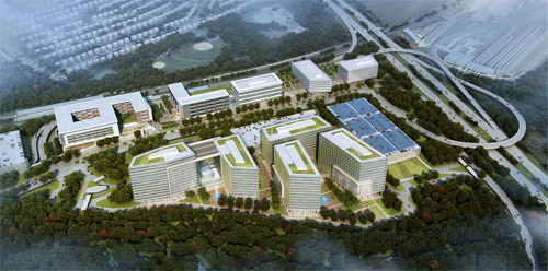
Greenbelt development rendering. Image from Renard Development/Gensler.
Under this plan, a new mixed-use transit-oriented development would replace the parking lot at the Greenbelt Metro station. The FBI would occupy the five buildings on the bottom of the rendering, with other offices, apartments, retail, and a hotel taking up the rest.
Greenbelt Metro station is located in the upper left side the rendering, immediately behind the building that looks like a “6” digit tipped on its side. To the right of that building, a central plaza would be the area’s main public space, and one of Prince George’s most urban spots.
Proposed view from the Greenbelt Metro station. Image from Renard Development/Gensler.
The Metro’s existing entrance is immediately behind the “6” building. It would be nice if a new Metro entrance would line up directly with the plaza, though it looks more like a short walkway behind the building will connect the station to the plaza.
Since Greenbelt is an end-of-line station, the development replaces all the Metro commuter parking. But instead of surface parking lots, it would go in a new parking garage shown on the far left of the overview rendering, connected to the station with a wide, suburban-style street.
Clustering mixed-use development next to the Metro station and putting the FBI buildings and park-and-rides across the street makes a lot of sense. That layout provides a parking lot for commuters and gives the FBI the space it wants for a buffer without sacrificing the walkability of the entire neighborhood.
Meanwhile, FBI workers who don’t commute via Metro would use the parking garage on the far right, next to the Beltway.
Overall, this looks like a decent plan. There are a lot of less than ideal trade-offs, but given the demands of an end-line station and the FBI, it’s not terrible.
Cross-posted at Greater Greater Washington.
Average Rating: 5 out of 5 based on 267 user reviews.
July 31st, 2014 | Permalink
Tags: development, urbandesign
|
Media


Site
About BeyondDC
Archive 2003-06
Contact
Category Tags:
Partners
|