|
Special Features


Image Libraries


|
|
Blog
I’m on vacation in Europe until the 24th. Each weekday until my return there will be a brief post about some feature of the city I’m visiting that day.
You can get anywhere on the Paris Métro. This map shows central Paris, with a 500 meter radius (roughly 1/3 mile) circle around every Métro and RER station. The entire city has subway station density comparable to downtown DC. Everywhere is within a short walk of at least one station.
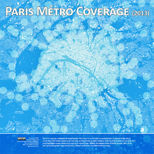
Map by mapsbynik on tumblr.
Average Rating: 4.8 out of 5 based on 209 user reviews.
March 14th, 2014 | Permalink
Tags: metrorail, transportation

I’m off for 10 days in Europe. Each weekday until my return there will be a brief post about some interesting urbanist or transportation feature of the city I’m planning to visit that day.
I’ll be spending most of time in Paris, but will also be stopping in a few other places.
Today, enjoy this view down the Avenue de la Grande-Armée, from the Arc de Triomphe.
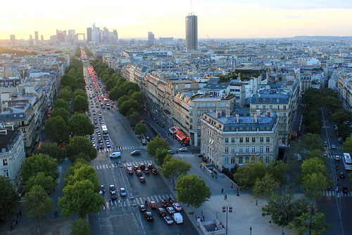
Paris. Photo by Cameron Wears on flickr.
Average Rating: 4.7 out of 5 based on 269 user reviews.
March 13th, 2014 | Permalink
Tags: urbandesign
There’s good news and bad news at the Reagan Airport Metro station. The bad news is an elevator is out of service, leaving one of the train platforms without elevator access. The good news is WMATA came up with a delightfully clever solution: Park a Metro railcar on the extra track between the two platforms, and use it as a pedestrian bridge to access the platform with the working elevator.
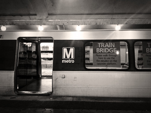
Metrorail “train bridge” at National Airport. Photo by Lily Monster on flickr.
The Metro station at Reagan National Airport has an unusual layout, with three rail tracks instead of the more normal two. There are two outside tracks, plus a third middle track. Two island platforms flank the middle track, each of them providing access to both the middle track and one of the outside tracks. West Falls Church has a similar layout.
The middle track is not actually necessary for day-to-day operations. So Metro parked a railcar on it and opened its doors, allowing passengers waiting on one of the platforms to use the railcar as a bridge to reach the other.
Thus passengers who need an elevator can access one. There’s no need to detour them to another station and make them wait for a shuttle.
WMATA is sometimes criticized for being overly bureaucratic, rigid, and slow to solve problems. But they deserve credit for this, a nimble and inexpensive solution that genuinely makes riding the system a little easier.
 Cross-posted at Greater Greater Washington. Cross-posted at Greater Greater Washington.
Average Rating: 4.6 out of 5 based on 243 user reviews.
March 12th, 2014 | Permalink
Tags: metrorail, transportation
The City of Fairfax isn’t a place that usually comes to mind when discussing cycletracks. But Fairfax does have one, and it’s bizarre. It runs 270 feet along the back side of a strip mall parking lot.
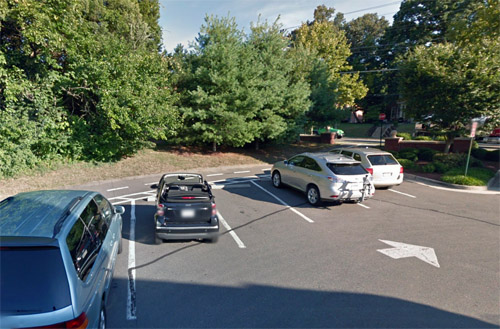
Fairfax’s cycletrack, behind the parked cars. Photo by Google.
The cycletrack is part of Fairfax’s Mason to Metro Trail, an assemblage of sharrows, sidewalks, and dedicated bikeways that runs from George Mason University to Vienna Metro station.
The cycletrack portion is just north of Fairfax Main Street. It curves around the back side of the Main Street Marketplace strip mall, using a cycletrack through the parking lot, and a simpler buffered bike lane through the loading dock.
It’s no 15th Street, but it’s something.
Cross-posted at Greater Greater Washington.
Average Rating: 4.8 out of 5 based on 162 user reviews.
March 11th, 2014 | Permalink
Tags: bike, transportation
Update: More tips & tricks are now listed at the bottom of this post! – 3.8.2014, 12:45 pm
Mini Metro is a fun browser game that simulates a transit network.
Stations representing different types of destinations pop up, and you have to connect them with metro lines that take passengers where they want to go.
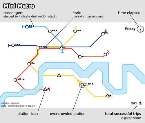
Screencap of the game, with components labeled.
The game starts off easy. You get one square station icon, one triangle, and one circle. Connect them with a single transit line and you’re all set.
But after a few moments more stations start to pop up. You have a limited number of metro lines to work with, and each line only gets one train. So the more stations appear, the longer it takes for a train to traverse the line, and the more passengers build up.
Ideally you want each transit line to cross at least one of every station type, to minimize transfers, but that soon becomes impossible when different types of stations begin to appear, like crosses and gemstones.
The game ends when too many waiting passengers build up at a station. The highest score I’ve gotten is about 500, but most of my games end in the 300s or 400s.
I’ve noticed certain types of stations seem to represent certain types of land uses.
Squares are employment centers, like downtowns. You start off with only one square, and you have to get quite deep into the game before a 2nd appears.
Circles are the most common station type, so they probably represent residential areas.
Triangles are the 2nd most common. I think of them as shopping areas, but they could be schools or parks.
Other symbols are rare, usually only appear once, and represent specialty land uses. I think of them as hospitals, airports, or universities.
How high can you score?
More tips & tricks:
- A hub and spoke layout works great in the early game, but once your score reaches about 350 you need to start moving to more of a grid.
- 6 stations is about the maximum any one line can accommodate before it gets overcrowded.
- You can pause the game by clicking on the clock.
- At key points in the game, pause the game to delete-and-redraw entire lines, along more efficient routes. Key points are typically when you add your 5th line, 3rd tunnel, and when the 2nd square appears.
- The order in which I usually use bonuses:
- Light blue line
- Longer/faster train
- Green line
- 3rd tunnel (sometimes sooner if the river is unfavorable)
- Bigger station
- Light rail (I’ve not seen this, but rumor says it appears next)
Cross-posted at Greater Greater Washington.
Average Rating: 4.5 out of 5 based on 190 user reviews.
March 7th, 2014 | Permalink
Tags: fun, transportation
Donation link
Greater Greater Washington wasn’t the first blog about urbanism or local policy-making in Washington, DC, but it’s the one that changed the discussion. It’s the one that brought arcane subjects like zoning and transit planning into the city’s mainstream.
By the time I first discovered Greater Greater Washington, I’d already been writing BeyondDC for many years. I was one of a cadre of bloggers writing about development and transportation, along with people like Richard Layman, and DCist’s Ryan Avent, .
But we were few and far between, and most of us either had other jobs or split our writing with other subject matters. DC’s online urbanist community, such as it was, had no home base and no leader. We were a niche network of geeky wonks, great at expressing opinions but not so good at building broad support.
Greater Greater Washington changed all that.
When David Alpert showed up, with his mountain of energy and dedication, that was a game-changer. David had the skills and time to do what the rest of us couldn’t. He went to public meetings, he drew maps, and he wrote, and wrote, and wrote. All of it was accessible to anybody. All of it was interesting, and exciting. All of it elevated the public discussion about what Washington could be.
And the readers poured in. Then some of the early readers started writing too, and the whole thing grew exponentially.
At first, I admit, I was a little jealous.
But it took me about 3 seconds to realize what was happening. A mere blog was becoming a community, and that was too wonderful a thing to pass up. I had to be part of that.
And become a community Greater Greater Washington did. With more writers and more readers, we started to have an impact. Not only on other policy wonks, not only on the editorial pages of other media, but on the tone of the discussion itself, and later on elected officials.
Now, everyone in town knows the practicality and benefits of car-free or car-light living. We can swing budgets, and change construction plans, .
Thanks to Greater Greater Washington, urbanists in the DC region are a political force. We’ve gone mainstream, and we’re making a difference.
Please help us keep making a difference. Please donate what you can to GGW, so our community will still have the strong voice it needs.
Cross-posted at Greater Greater Washington.
Average Rating: 4.4 out of 5 based on 290 user reviews.
March 5th, 2014 | Permalink
Tags: events, site
A startup maglev manufacturer that’s never built a functioning transit system is stirring up controversy in Virginia Beach, claiming they can build a levitating, elevated high speed maglev from Norfolk to Virginia Beach for 1/3 the cost of surface light rail.
Yeah right. And if you believe that, they can probably sell Hampton Roads a couple of bridges, too.
Unfinished maglev at Old Dominion University. Photo by withvengeance86 on flickr.
Elevated rail is more expensive than surface rail. New technologies are more expensive than proven ones, and maglev in particular (on which trains levitate above a magnetic field rather than glide on tracks) has been super expensive wherever built. And since Norfolk already has light rail, you’d be forcing a transfer unnecessarily.
Oh, and this same company tried to build a maglev at Old Dominion University in Norfolk years ago, and never finished.
This is all reminiscent of the California hyperloop proposal. They’re both completely unrealistic, almost certainly built on either faulty assumptions or outright lies, and serve no purpose but to strip support away from actually practical transit options.
I hate to be a closed minded curmudgeon. Maglev trains are cool and can work. Absent the claim that this could be done for 1/3 the cost of light rail, it might be worth exploring. But we have enough experience with other maglev proposals to know this one smells fishy.
Average Rating: 4.8 out of 5 based on 166 user reviews.
March 4th, 2014 | Permalink
Tags: lightrail, transportation
|
Media


Site
About BeyondDC
Archive 2003-06
Contact
Category Tags:
Partners
|