|
Special Features


Image Libraries


|
|
Blog
DDOT's latest plan to redesign Florida Avenue shows a high quality protected bikeway between NoMa and West Virginia Avenue.

Florida Avenue protected bikeway proposal. Image by DDOT.
This new plan came as a surprise when DDOT presented it Tuesday night. Previous plans had only called for shorter unprotected bike lanes.
But this stretch of Florida Avenue is the only practical connection for people riding bikes to NoMa Metro from the Trinidad neighborhood or much of DC's Near Northeast. Since collisions have been a problem here, and since the street is wider than the fast-moving car traffic on it warrants, a stronger bikeway makes sense.
Details of the design
The complete block-by-block plan is available online. It shows a two-way curb-protected bikeway on the south side of Florida Avenue, beginning at 3rd Street NE just east of the Red Line Metrorail tracks, and running east until 9th Street NE just shy of West Virginia Avenue.
To reach West Virginia, the key connection into Trinidad and north into Ivy City, the bikeway jumps up onto the sidewalk for one block. DDOT will widen that sidewalk so it can accommodate people on both bikes and foot. From there, a two-stage bike box will help cyclists turn left onto West Virginia.

Bikes will use the sidewalk and a two-stage bike box between 9th Street and West Virginia Avenue. Image by DDOT.
East of West Virginia Avenue, Florida Avenue narrows significantly. DDOT isn't proposing to carry the bikeway into the narrower section.
That stub ending has riled some community members, who've reached out to Ward 5 Councilmember Kenyan McDuffie to push for extending the bikeway all the way to Starburst intersection, where Florida Avenue ends. But extending the bike lanes east of West Virginia would likely mean either removing parking or making Florida Avenue one-way, both long-shot propositions.
As of now, this plan is at the 30% design level, which means engineers have a basic design for the entire length of the project, but it's not yet precise enough to actually build. The full construction-level design will take another year to prepare; DDOT says to expect it in Spring of 2018.
In the meantime, you can use the project website to learn more, and to leave comments.
 Comment on this at the version cross-posted to Greater Greater Washington. Comment on this at the version cross-posted to Greater Greater Washington.
Average Rating: 5 out of 5 based on 283 user reviews.
February 23rd, 2017 | Permalink
Tags: bike, transportation

Almost every large city in the United States now has bikeshare. Any city without it should count itself way, way behind the curve. There are at least 119 systems nationwide, covering all but two of the 20 largest urban areas.
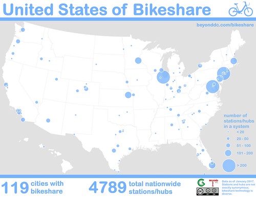
This map shows every bikeshare system in the country with at least two stations. The 119 nationwide systems together have about 4, 800 stations.
The largest networks by far are in New York, Chicago, and Washington. A second tier is led by Minneapolis, Boston, and Miami.
Of the 20 largest urban areas, only Saint Louis and Detroit still lack bikesharing. Unfortunately, Seattle’s Pronto will be the first major US bikeshare system to fail when it shuts down in March, adding a third.
Here are the ten largest systems. Or see the complete list of all 119.
Ten largest US bikeshare systems
There’s so much bikeshare, and its so diverse, that it’s hard to count
It’s been less than 10 years since the first large-scale bikesharing systems debuted in the United States. In that time, bikes have spread like wildfire across the country. This list only includes networks with at least two stations, but bikesharing has become so ubiquitous that individual buildings now offer single-station systems.
Even then, I’ve probably missed a few. It’s become virtually impossible to count them all. If you know of a missing system, mention it in the comments at GGWash.
Furthermore, it’s hard to compare the systems on an apples-to-apples basis. The older and larger bikeshare systems rely solely on stations to dock bikes. But many newer systems don’t need docks, or have simple racks instead of docks that serve as hubs. Comparing “hubs” and “stations” can exaggerate the size of hub-based systems.
That explains Topeka, which clocks in at number seven on the nationwide list with 138 hubs. But Topeka’s an unusual network; it actually has more hubs than bikes. With only about 100 actual bicycles, most of its hubs are usually empty. The network functions uniquely from any other in the country; even other hub-based systems don’t have that kind of ratio.
Topeka’s urban area is about the same population as Frederick, Maryland, so its system is remarkable no matter what. But it’s not actually larger than Philadelphia’s. If Topeka were a station-based network, it would probably have around a dozen stations.
The full 119-station list indicates hub-based systems with an asterisk, so you can spot them.
Thanks to The Bike-sharing Blog for its excellent resources on worldwide bikeshare locations.
Comment on this at the version cross-posted to at Greater Greater Washington.
Average Rating: 4.9 out of 5 based on 230 user reviews.
January 26th, 2017 | Permalink
Tags: bike, transportation
As 2017 gets underway, there are at least 23 protected bikeways in the Washington region, totaling about 8.5 miles. This map shows them all.
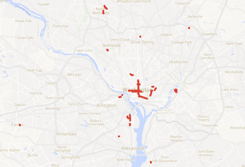
Protected bikeways in the Washington region.
Or at least, all those I know about. There are so many now that it's becoming hard to keep track.
The 23 bikeways range from lengthy to minuscule. DC's 15th Street cycletrack is both the oldest in the region and, at about 1.6 miles, the longest. On the other end of the spectrum are microscopic sections of normal unprotected bike lane where a few plastic bollards add a tiny degree of separation for a short stretch. The smallest is at the corner of New Hampshire Avenue and U Street, where a mere 60 feet of lane is protected with curb and flexposts.
The District has by far the most mileage of protected bikeway, with about 7 miles and all of the five longest individual bike lanes. After DC, Arlington and Montgomery are in a virtual dead heat for second place, each hovering with almost exactly one mile of protected bikeway, spread across four separate locations in each county.
Prince George's, Alexandria, and Fairfax City each have tiny cycletracks, combining for one-quarter mile.
For the future, DC has grand plans for a vast cycletrack network, and more jurisdictions are beginning to work on their own. Expect this map to expand in coming years.
In the meantime, if you know of an existing protected bikeway that's not on this map, leave a comment to let us know.
Update: This post has been updated to reflect additional protected bikeway segments that were missing from the original map.
Comment on this at the version cross-posted to Greater Greater Washington.
Average Rating: 4.8 out of 5 based on 191 user reviews.
January 3rd, 2017 | Permalink
Tags: bike, maps, transportation
Do you know a DC newbie who needs a primer on how to get around the city without a car? I wrote one for ApartmentGuide.com. Check it out!

DC bus map, learn to love it to unlock the city.
Average Rating: 4.7 out of 5 based on 172 user reviews.
November 29th, 2016 | Permalink
Tags: bike, bus, metrorail, pedestrians, roads/cars, streetcar, transportation
Say hello to the Rhode Island Avenue protected bikeway. It’s only 250 feet long and it only covers 1/3 of a block, but it exists.

College Park’s short protected bikeway. Photo by Matt’ Johnson.
The protected lane is part of the larger College Park Trolley Trail. For most of its length the Trolley Trail runs either off-street or as normal on-street bike lanes. But for this short segment in front of Hollywood Shopping Center, a concrete barrier makes it a legit, if short, protected bikeway.
As far as I know, it’s the first protected bikeway in Prince George’s County.
Welcome to the club, Prince George’s!
Comment on this at the version cross-posted to Greater Greater Washington.
Average Rating: 4.4 out of 5 based on 288 user reviews.
August 4th, 2016 | Permalink
Tags: bike, transportation
On June 11, Arlington closed a block of bustling Wilson Boulevard for what organizers called the Active Streets Festival. There were bike-oriented games and activities, plus a collection of temporary bikeways “built” with tape, paper, and potted plants.

Pop-up protected bikeway. Photo by BikeArlington.
The festival took place during the Air Force Association cycling race, when many Arlington streets were closed anyway. The Active Streets Festival gave Arlingtonians who weren’t racing something bike-related to take part in.
Planners “built” a series of temporary bike lanes, all on the block of Wilson Boulevard between Washington Boulevard and 10th Street North.
On one section, a row of potted plants formed the barrier for a protected bike lane. On another, a row of parked cars did the same. Elsewhere, washable homemade green “paint” and a thick roll of tape formed a green bike lane, a buffered bike lane, and sharrows.

Pop-up green lane and buffered bike lane. Photo by BikeArlington.
By using easy-to-set-up and easy-to-take-down temporary materials, Arlington planners tangibly showed residents what Wilson Boulevard might look like if its street space were allocated differently. There’s no proposal to change Wilson permanently, but the example can be instructive for future projects on other streets.

A BikeArlington worker lays down strips of tape to create the buffered bike lane. Photo by BikeArlington.
Tangible benefits aside, the whole thing was a heck of a lot of fun.

Wilson Boulevard with its pop-up bike lanes in place. Photo by BikeArlington.
Comment on this at the version cross-posted to Greater Greater Washington.
Average Rating: 4.9 out of 5 based on 173 user reviews.
June 23rd, 2016 | Permalink
Tags: bike, events, transportation
Rockville Pike could one day become a 252-foot-wide mega boulevard with 12 car lanes, 4 bike lanes, 2 bus lanes, and over 50 feet of landscaping. But in designing a street with more than ample room for cars, bikes, and buses, planners abandon any hope the street will be walkable.

The plan for Rockville Pike. Image from Rockville.
Everybody gets a lane!
Rockville Pike is one the most important retail strip highways in the Washington region. Like most 20th Century retail roads, it’s designed for cars, and it carries a lot of them.
Rockville wants to make it a more urban main street, so planners there are drawing up a redevelopment plan. It’s a laudable goal, and it’s not easy on a high-traffic state highway like Rockville Pike.
At first glance, this plan has all the components of a good complete street design: Tree-lined sidwalks, protected bikeways, a center-running dedicated busway. Every mode gets all the street width it could possibly want.
And why not? Why go through the political headache of forcing the community to make the difficult choice between fewer car lanes versus bikes or BRT if you can fit everything in? With a mega boulevard like this, everybody gets what they want, and nobody loses. Right?
Wrong.
Walkability loses, and it’s the most important factor
At 252 feet wide, the new Rockville Pike will be practically impossible for pedestrians to cross. It will take multiple traffic light cycles and multiple minutes for anyone to cross.
Instead of a main street, Rockville will have a barrier. And that is a big problem for the rest of the plan.
Transit oriented development doesn’t work unless it’s walkable. If Rockville Pike is too wide, development on one side of the street will be effectively cut-off from development on the other side. Riders won’t be able to easily access the BRT stations. People will drive for even short trips. The concept of a community where people don’t need to drive everywhere will break down.
If you can’t walk, other multimodal options don’t work. Pedestrians are the linchpin to the whole thing.
To be sure, some level of compromise is always needed. If walkability were the only factor that mattered, all streets would be pedestrian-only. We add in car lanes, bike lanes, and transit because we have to make longer trips possible, and that’s a good thing.
But there’s a balance, and 252 feet veers so far to accommodate long distance travel that it seriously sacrifices short distance walking. In so doing, Rockville undermines the very foundation on which its redevelopment plans rest.

Make pedestrians a priority
The Pike needs to be narrower. Assuming the sidewalks, busway, and three general car lanes each direction are sacrosanct, that still leaves a lot of potential fat to trim.
Are the service roads really necessary if the plan also includes new parallel local streets? Do we really need redundant bi-direction bikeways next to both sidewalks? Could we possibly reduce the 74 feet of various landscaping, buffer, and turn lanes?
These would be difficult trade-offs, to be sure. But there are massive negative consequences to an uncrossable mega boulevard.
If Rockville wants the new Pike to work as multimodal urban place, pedestrians need to become a priority.
Comment on this at the version cross-posted to Greater Greater Washington.
Average Rating: 4.6 out of 5 based on 188 user reviews.
March 24th, 2016 | Permalink
Tags: bike, BRT, master planning, roads/cars, transportation, urbandesign
Over 20% of commuters in Bloomingdale, Mount Pleasant, and Petworth get to work each day primarily using a bicycle. That doesn’t even include people who use bikes to reach Metro.
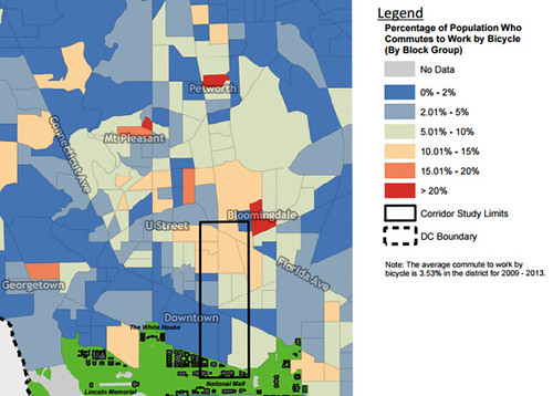
Bike mode share in central DC. Image from DDOT.
This fascinating map is part of the background data DDOT is preparing to study a possible protected bikeway on or around 6th Street NW.
It shows how hugely popular bicycling can be as a mode of transportation, even in the United States. What’s more, this data actually undercounts bicycle commuters by quite a lot.
It’s originally from the US Census’ American Community Survey, which only counts the mode someone uses for the longest segment of their commute. People who bicycle a short distance to reach a Metro station, then ride Metro for the rest of their commute, count as transit riders rather than bicyclists.
Comment on this at the version cross-posted to Greater Greater Washington.
Average Rating: 5 out of 5 based on 232 user reviews.
February 8th, 2016 | Permalink
Tags: bike, maps, transportation
What do you do if you have active freight rail tracks running down the middle of a downtown street? Add bike lanes, of course!
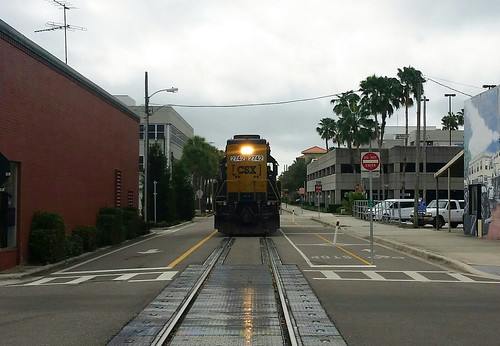
East Avenue, Clearwater, FL.
This is East Avenue in downtown Clearwater, Florida. It’s one of America’s most unusually multimodal streets.
On the left: A normal one-way general purpose lane with normal car traffic. In the middle: Freight rail tracks. On the right: A major regional two-way bikeway, the Pinellas Trail. What could go wrong?
Actually, it’s not as dangerous as it looks. Freight traffic on those tracks is relatively light, and extremely slow-moving. The train in this photo was moving maybe five miles per hour. And unlike cars, trains don’t suddenly change lanes. There’s zero danger of a CSX right hook.
In fact, the rail tracks are effectively a buffer between the bikeway and car lane. They make a bigger buffer than normal buffered bike lanes get. In a weird way, the tracks are a sort of protection.
So it’s totally bonkers. But maybe it works.
What do you think?
Comment on this at the version cross-posted to Greater Greater Washington.
Average Rating: 4.4 out of 5 based on 295 user reviews.
January 13th, 2016 | Permalink
Tags: bike, fun, transportation, urbandesign
This is Main Street on Mackinac Island, in Lake Huron, Michigan. It’s a Michigan state highway, M-185, and it’s car-free year round.

Photo from Google.
M-185 encircles Mackinac Island, and forms the main street of the island’s town.
There’s no bridge to Mackinac Island. Visitors access it via airplane or ferry. With a lot of tourists but not many cars, M-185 has been car free since 1898.
I’ve never been there, but it looks pretty impressive in photos.
Have you been to Mackinac? Tell me what you think in comments at GGW.

The density of parked bikes looks like the Netherlands. Photo by Jasperdo on Flickr.

Photo by Jasperdo on Flickr.

Photo by Jasperdo on Flickr.

Bike for rent. Photo by ellenm1 on Flickr.
Comment on this at the version cross-posted to Greater Greater Washington.
Average Rating: 4.4 out of 5 based on 212 user reviews.
October 19th, 2015 | Permalink
Tags: bike, galleries, transportation
|
Media


Site
About BeyondDC
Archive 2003-06
Contact
Category Tags:
Partners
|


