Now that MARC’s Penn Line runs on the weekend, it’s easier than ever for Washingtonians to day-trip up to Baltimore. I made use of the service over the winter, for no reason but to bum around and take some pictures. That’s the sort of thing a city nerd like me enjoys.
If you’re enough of a city nerd to look at my pictures, here they are.
Average Rating: 4.4 out of 5 based on 283 user reviews.
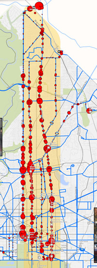
Every circle on this map is one bus stop. The larger the circle, the more riders get on or off at that stop.
The map shows where riders are going on WMATA’s busy 16th Street, 14th Street, and Georgia Avenue lines, plus a couple of smaller routes in the same part of town.
It’s a fascinating look at transit ridership patterns in DC’s densest corridor. And it correlates strongly with land use.
Georgia Avenue is a mixed-use commercial main street for its entire length. Thus, riders are relatively evenly distributed north-to-south.
16th Street, on the other hand, is lined with lower density residential neighborhoods north of Piney Branch, but is denser than Georgia Avenue south of there. It’s not surprising then that 16th Street’s riders are clustered more heavily to the south.
14th Street looks like a hybrid between the two, with big ridership peaks south of Piney Branch but also more riders further north of Columbia Heights. 14th Street also has what appears to be the biggest single cluster, Columbia Heights itself.
DDOT produced this map as part of its North-South Corridor streetcar planning. It’s easy to see why DDOT’s streetcar plans are focusing on 14th Street to the south and Georgia Avenue to the north.
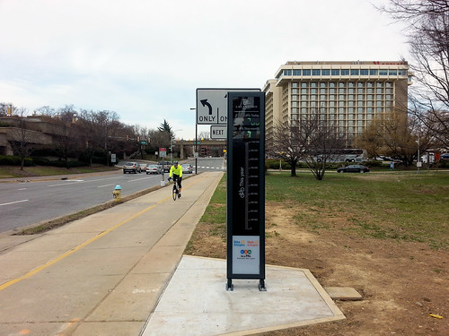
Yesterday Arlington unveiled the region’s first “bikeometer, ” a high-tech device that counts how many cyclists pass by, and displays the daily and yearly totals for anyone to see.
By publicly displaying the data, the bikeometer helps illustrate that a lot of people really do use bikes to get around.
Arlington bikeometer. The numbers aren’t visible due to the camera scanning frequency. Photo by BeyondDC.
The bikeometer is on the Custis Trail in Rosslyn, near the Key Bridge. It’s a busy crossroads for cycling traffic headed into DC from Virginia. Older bike counts have shown thousands of cyclists per day at the location.
As of about 11:30 am yesterday, after only a couple of hours running, the display already showed 768 cyclists.
The device is technically called an Eco-TOTEM. It reads an underground wire, which counts bikes rolling over the trail above and sends the data to a digital display.
Arlington’s bikeometer is the first such device in the eastern US, although they’re common on the west coast and in Europe.