|
Special Features


Image Libraries


|
|
Blog
|
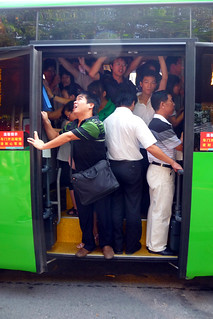
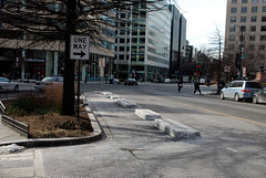
Overcrowded bus.
Photo by dcmaster on flickr. |
More and more people are riding the bus in DC. That’s great, but it’s also straining the system to its limits. Experts from DDOT and WMATA will discuss how to make buses work better for more people at a free panel on Wednesday evening.
Buses come every couple of minutes on WMATA’s busy 16th Street line. But it’s not enough. Rush hour passengers often watch bus after bus pass by, too jam packed to allow even one more person on board. Other lines face similar problems, or soon will.
What can we do? Simply adding more buses may not work, because there are so many buses already on 16th Street that they bunch together, forming long pseudo-trains where multiple buses all come at the same time. Even if the last bus is empty, bunching like that slows down the entire line for everyone; waiting passengers wait longer, and moving buses move slower.
Meanwhile, WMATA’s central DC bus storage barn doesn’t have any extra room for new or bigger buses, so even adding more articulated buses would be difficult, expensive, and take years of planning.
Streetcars could increase capacity, but they’d take even longer to implement. And they work better for shorter trips on commercial streets anyway, as opposed to the longer commute trips common on 16th Street.
Bus lanes are a possibility, but repurposing car lanes for transit takes a lot of political courage. So far leaders in DC haven’t been willing to take that leap.
What’s left? What can we do? Or can longer buses or bus lanes actually work?
Come to 1701 16th Street NW on Wednesday from 6:00 – 8:00 pm to hear experts weigh in. Panelists include DC Councilmember Mary Cheh, WMATA’s head bus planner Jim Hamre, DDOT transit planner Sam Zimbabwe, and former New York City Director of Transit Planning Joseph Barr.
RSVP with the Coalition for Smarter Growth.
Average Rating: 4.4 out of 5 based on 263 user reviews.
April 29th, 2014 | Permalink
Tags: bus, events, transportation

Well folks, the long-awaited M Street cycletrack is finally going in.
Average Rating: 4.9 out of 5 based on 258 user reviews.
April 25th, 2014 | Permalink
Tags: bike, transportation

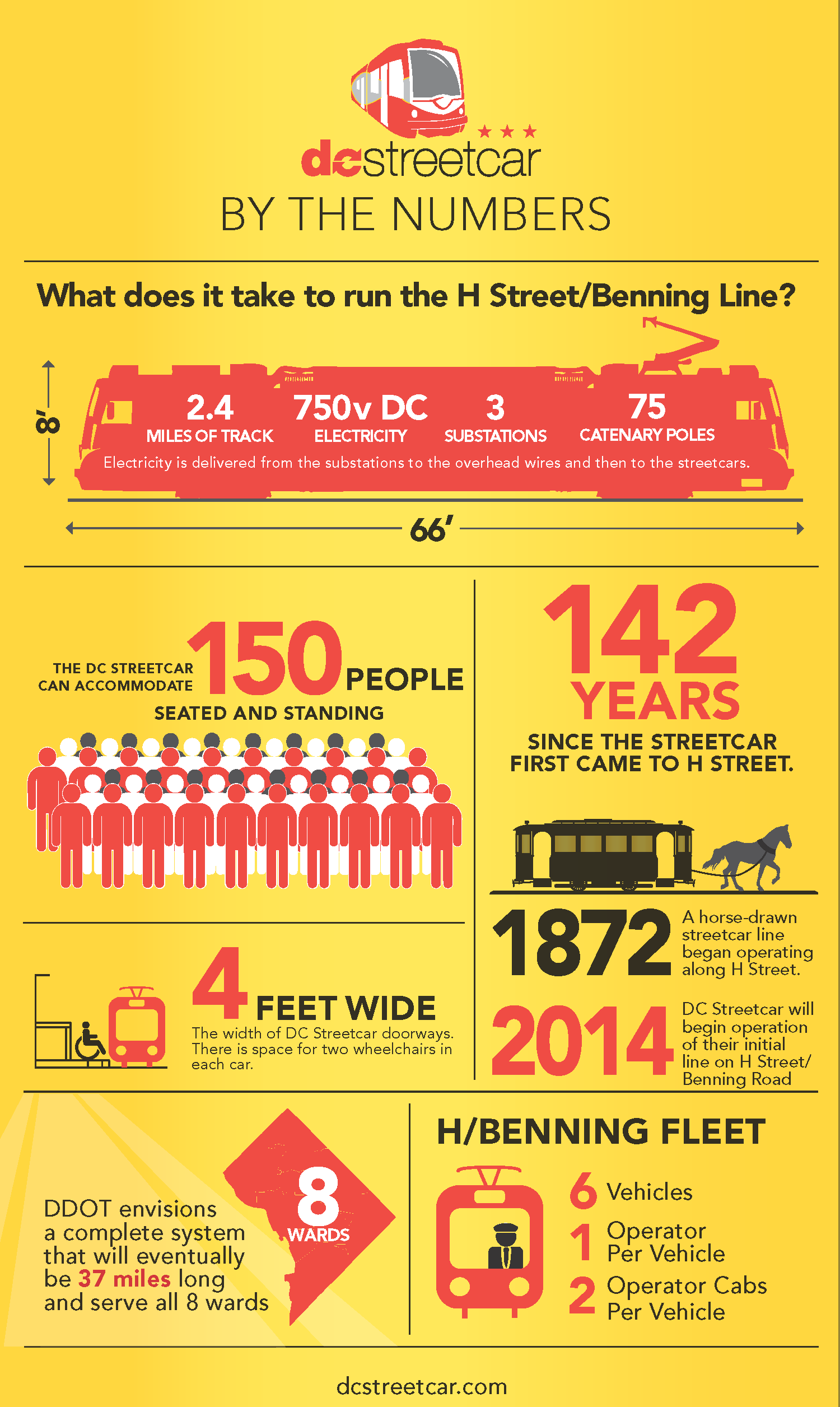
Average Rating: 4.9 out of 5 based on 264 user reviews.
April 23rd, 2014 | Permalink
Tags: streetcar, transportation
Not to be outdone by its neighbors’ aggressive plans for rail and BRT networks, Fairfax County has an impressive transit plan of its own.
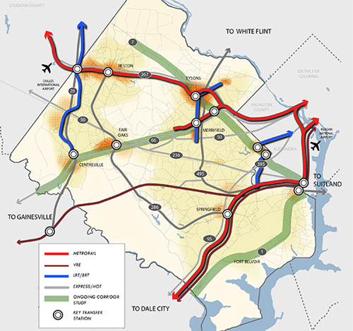
Fairfax County’s proposed high quality transit network. Image from Fairfax.
DC has its streetcar and moveDC plans, Arlington and Alexandria have streetcars and BRT, and Montgomery has its expansive BRT network, plus of course the Purple Line.
Now Fairfax has a major countrywide transit plan too, called the High Quality Transit Network.
Fairfax’s top priorities are to finish the Silver Line and the Bailey’s Crossroads portion of the Columbia Pike streetcar, but that’s not the end of their plans.
County planners are also looking at several other corridors, including Route 1, Route 7 (both east and west of Tysons), I-66, Route 28, and Gallows Road/Dolly Madison Boulevard.
Both rail and BRT are possibilities for all those corridors. Some may end up light rail or streetcar, others bus. Route 1 and I-66 could even include Metrorail extensions.
In addition to all that, Fairfax County Parkway is slated for HOT lanes, which could make express buses a more practical option there.
As the DC region continues to grow, and demand for walkable, transit-accessible communities continues to increase, these types of plans are crucial. If our major arterial highways are going to become the mixed-use main streets of tomorrow, transit on them must significantly improve.
Fairfax is undeniably still spending a lot on bigger highways. Planners’ inability to calm traffic on Routes 7 and 123 through Tysons, for example, indicates roads are still priority number one. But it takes a plan to change, and this is a strong step forward. So good on Fairfax for joining the club.
 Cross-posted at Greater Greater Washington. Cross-posted at Greater Greater Washington.
Average Rating: 4.6 out of 5 based on 182 user reviews.
April 22nd, 2014 | Permalink
Tags: BRT, land use, lightrail, master planning, metrorail, roads/cars, streetcar, transportation
The latest future population projections forecast that by 2040 the District of Columbia will have a population of 883, 600. That would far eclipse the historic high of 802, 178, from the 1950 census.

Projected population increase from 2010 to 2040, in thousands. Image by COG.
Despite that growth, DC would still rank as only the 4th most populous jurisdiction in the region, behind Fairfax, Montgomery, and Prince George’s. But the next 26 years could narrow that gap considerably. Demographers project that only Fairfax will add more people than DC. Prince George’s will add fewer than half as many.
The forecasts come from the Metropolitan Washington Council of Governments (COG), which is sort of a United Nations for local governments in the DC region.
COG’s forecast report has a treasure trove of fascinating demographic info, not only about population, but also jobs and households. For example, by 2040 COG’s demographers expect DC to have over 1 million jobs.
Of course, these are only projections. Nobody can predict the future with 100% accuracy. COG’s forecasts often fail to predict the biggest peaks during booms and lowest dips during busts. But all in all they’ve historically been reasonably accurate.
So get ready for more neighbors.
Cross-posted at Greater Greater Washington.
Average Rating: 4.8 out of 5 based on 217 user reviews.
April 17th, 2014 | Permalink
Tags: demographics
There are more than 300 million people living in the United States today, but America is such a huge country that we still have staggeringly vast areas that are completely devoid of humans. This map illustrates those places. Everything colored green is a census block with zero population.

Map by Nik Freeman of mapsbynik.com.
The eastern US is pretty well populated except for a few spots in mountains and swamps. But the west is a different story. It’s covered with enormous stretches of land that are simply empty.
And Alaska’s emptiness makes even the western contiguous states look densely populated. Those green areas near the Arctic Circle look bigger than most other states.

Map by Nik Freeman of mapsbynik.com.
Cross-posted at Greater Greater Washington.
Average Rating: 5 out of 5 based on 247 user reviews.
April 16th, 2014 | Permalink
Tags: demographics, land use, maps
Two new cycletracks will open in DC this spring, on M Street NW and 1st Street NE. Their designs are a step up from previous DC cycletracks, since they each include spots — though on M, a very brief spot — where a full concrete curb separates bikes from cars.
 |
 |
The 1st Street NE cycletrack (left), and the Rhode Island Avenue portion
of the M Street NW cycletrack (right). |
The 1st Street NE cycletrack connects the Metropolitan Branch Trail to Union Station and downtown DC. DDOT installed its curb last week, from K Street to M Street. Crews are still working on striping and signals, but the project is close to opening.
The M Street cycletrack is longer than 1st Street’s overall, but the portion with a curb is shorter. It’s less than one block, where the cycletrack briefly curves onto Rhode Island Avenue in order to approach Connecticut Avenue more safely. DDOT officials say the M Street cycletrack is a week or two from opening.
Typically DDOT uses plastic bollards instead of curbs. The bollards are less expensive, easier to install, and can be removed occasionally to perform street maintenance. But they’re less attractive and less significant as a physical barrier, compared to a curb.
Average Rating: 4.7 out of 5 based on 273 user reviews.
April 14th, 2014 | Permalink
Tags: bike, transportation
Fairfax County is considering dressing up the Silver Line’s mammoth concrete pylons with murals. The idea could help animate the otherwise bleak, gray structures.
Mock up of a possible Silver Line mural. Image from the Tysons Partnership.
Ideally the Silver Line would’ve been underground through Tysons Corner. But federal rules that have since changed prevented that, forcing the Metro line above ground, onto a huge elevated structure.
That wasn’t the end of the world, but it did condemn Tysons to some unnecessary ugly.
So why not dress it up? Murals can unquestionably make big gray structures more colorful and interesting. They’re easy to implement, don’t cost very much, and help a little. There’s not much down side.
Murals are, however, still just lipstick on a pig. They don’t solve the underlying deadening effect of bare walls. For example the Discovery building mural on Colesville Road in Silver Spring is surely better than bare concrete, but shops & cafes would’ve been better still.
And Tysons’ murals won’t be as effective as the one in Silver Spring. Colesville Road is basically urban, basically walkable. The block with the mural is the weakest link on an otherwise lively urban street.
But in Tysons, the Silver Line runs down the middle of Leesburg Pike, one of the most pedestrian-hostile highways in the region. If murals are added to the Silver Line, they may become the best and most interesting part of the streetscape, as opposed to the worst.
So by all means, Fairfax County should absolutely do this. Murals are a great tool to cover any large blank structure. But what Tysons really needs is walkable streets with lively sidewalks.
Cross-posted at Greater Greater Washington.
Average Rating: 4.4 out of 5 based on 150 user reviews.
April 11th, 2014 | Permalink
Tags: architecture, metrorail, transportation, urbandesign
What does it look like when one of Philadelphia’s most prominent skyscrapers becomes a giant Tetris game board?
It looks awesome, that’s what.

Photo by Bradley Maule for PhillySkyline.com.
Last Saturday, organizers for Philly Tech Week temporarily turned the 29-story Cira Centre into a huge game of Tetris. And it wasn’t just for looks. Actual people played actual games, with the whole city looking on.
Meanwhile, construction is wrapping up on the DC region’s new tallest skyscraper. Just sayin’.
Cross-posted at Greater Greater Washington.
Average Rating: 4.8 out of 5 based on 228 user reviews.
April 10th, 2014 | Permalink
Tags: fun
Often when a new city proposes its first rail line, opponents who don’t like spending money on transit call for BRT instead. So it’s tempting to think cities might have an easier time implementing new transit lines if they simply planned BRT from the start. Unfortunately, BRT often faces the exact same opposition.
 |
 |
| Two projects that have faced major opposition, the Nashville BRT (left) and Cincinnati streetcar (right). Images from the cities of Nashville and Cincinnati. |
Nashville is the latest city to face strong opposition to its first BRT project, called the Amp. The Tennessee state legislature recently passed a bill blocking the line.
The debate mirrors one going on a few hundred miles north, in Cincinnati. There, opponents tried to kill that city’s first streetcar line. The state government even tried to block it.
Both Nashville and Cincinnati are among America’s most car-dependent and least transit-accessible large cities. Nashville’s entire regional transit agency only carries about 31, 000 passengers per day. Cincinnati’s carries about 58, 000.
For comparison, Montgomery County’s Ride-On bus carries 87, 000, never mind WMATA.
In places like Nashville and Cincinnati, authorities have ignored transit for so long that any attempt to take it seriously is inherently controversial, regardless of the mode.
Arguments may fixate on rails, dedicated lanes, or overhead wires, but for at least some opponents those issues seem to be simply vehicles for larger ideological opposition.
That may sometimes be true even in places with stronger transit cultures. Arlington’s streetcar and Montgomery’s BRT network are both controversial themselves. Both have plenty of detractors who say the plans are unaffordable or would get in the way of cars.
Ultimately there are many reasons a city hoping to improve transit might choose BRT or rail. The two modes are both useful, and smart cities use them both based on the specific needs of the location.
But either way, expect similar tropes from opposition. It’s inescapable.
Cross-posted at Greater Greater Washington.
Average Rating: 4.6 out of 5 based on 263 user reviews.
April 9th, 2014 | Permalink
Tags: BRT, streetcar, transportation
|
Media


Site
About BeyondDC
Archive 2003-06
Contact
Category Tags:
Partners
|