|
Special Features


Image Libraries


|
|
Blog
There were few posts this past week because I’ve been busy trying to get out of town for a vacation in Montreal. I’ll be away until Labor Day, and won’t be likely to blog while gone.
When I return you can expect pictures and some discussion of the city (in particular its expansive bike-sharing system). In the mean time I’ll be tweeting regularly.
Please feel free to use the comments section of this post as an open thread. Any thoughts or questions you have about urbanism, transit, blog operation, etc are welcome.
Average Rating: 4.9 out of 5 based on 209 user reviews.
August 28th, 2009 | Permalink
Tags: open, site

Affordable housing isn’t quite the problem now that it was during the bubble, but there is still a lot of ingrained exclusivity in the system that keeps us from providing affordable housing as efficiently as we did in the past. Apartments above shops, granny flats, shared-houses, the places that served as affordable housing for most of American history are now illegal in a very large part of America.
Matt Yglesias adds an interesting twist to the story with a table comparing housing attributes in 1900 and 1990. As the table makes clear, a lot of things have gotten unquestionably better. Running water, electricity, heat, all enjoyed by virtually all homes now (or rather by 1990) and few then. But one statistic jumps out that informs the question of affordable housing: In 1990 24% of American households put up a boarder or lodger. That is to say, nearly a quarter of all American homes included at least one person who wasn’t a member of that household, but paid rent for access to a room. In 1990 that same statistic was down to 2%. What was an extremely common form of affordable housing, perhaps the country’s most common, is now effectively unheard of.
I can think of a few theories that might account for why such a common attribute so completely fell off the map: migration away from rural areas, income homogeneity in post-war suburbs, World War II itself and the GI Bill, exclusivity regulations as mentioned in the first paragraph, etc. But no matter why or how the common lodger ceased to exist, the effect has been that by removing such a sizable chunk of housing from the affordability market we have increased the demand for affordability by other means. The folks who might otherwise live in a rented-out basement are instead trying to find their own dedicated unit. That drives up demand for dedicated affordable units, which unless coupled with an equally dramatic increase in supply, inevitably drives up their cost in turn, making fewer and fewer of them affordable.
The only way out, short of hoping the economy never recovers, is probably to make it legal and much easier to provide a large number of affordable units, either as accessories to other units or on their own. Developers, after all, will build to fill any niche market they can find, provided they are permitted to do so by law.
Average Rating: 4.6 out of 5 based on 250 user reviews.
August 25th, 2009 | Permalink
Tags: economy, history
Arlington County has been leading the way on Transit Oriented Development for decades now. The County is so committed to the concept because statistic after statistic shows that it works; there is simply no better way of managing growth known to contemporary planning.
As I sat in a meeting this morning, I heard a couple of statistics that have recently come out of research by Arlington’s Department of Transportation that offer incredibly compelling evidence of the power of TOD:
1. Auto traffic counts in the Pentagon City area are level today compared with counts from 1975. Despite all the development that has occurred there in that time frame, including construction of one of the region’s largest and busiest shopping malls, there has been no measurable increase in traffic congestion.
And if you can believe it, that’s the less compelling of the statistics I heard. Sit down for the next one:
2. 1, 000 units of urban-format TOD housing generates fewer auto trips per day than a single suburban-format McDonalds or 7-11. You can build 1, 000, 000 square feet of residential TOD and generate less congestion than 2, 000 square feet of auto-oriented retail.
Holy cow.
Average Rating: 4.7 out of 5 based on 197 user reviews.
August 24th, 2009 | Permalink
Tags: urbandesign
|

Cyclists (including NYDOT boss Janette Sadik-Khan) enjoying the ciclovia on Park Avenue. Click to enlarge. |
It has been pointed out to me that the woman on the far left side of this image, which was featured on the BDC home page earlier this week is actually none other than Janette Sadik-Khan, Commissioner of the New York City Department of Transportation and the mind behind many of New York’s recent pedestrian and bicycle initiatives. Small world.
Average Rating: 4.8 out of 5 based on 287 user reviews.
August 21st, 2009 | Permalink
Tags: people
| This week’s top tweet from @BeyondDC:
@beyonddc Sitting at car-less times square. only someone who hates people could think this is a bad idea. Have the doubters SEEN IT? Unbelievable.
| This week’s top tweet from the network:
@barkway why is every car mandated to be insured but not every person? |
Average Rating: 4.9 out of 5 based on 177 user reviews.
August 21st, 2009 | Permalink
Tags: twitter summary
There is an article in the Post today about development in Lovettsville, a sleepy hamlet northwest of Leesburg. Apparently as sprawl approached the town, planners drew up plans for a traditional walkable town center to anchor new development. Then the recession hit, and the grand plans came crashing down. Planned mixed-use has been un-planned, rules requiring alleyways have been rewritten, and plots for big expensive mcmansions have been replaced by diminutive starter homes. The shift to more affordable housing is a positive one, but the rest sounds unfortunate, and highlights the difficulties developers often face when trying to build walkable communities. When the going gets tough, defaulting back to normal sprawl is easier and cheaper. It shouldn’t be, but it is. Institutional supports for sprawl guarantee it.
One of these days I’m going to have to visit Lovettsville, as well as its exurban fringe TND cousin in Montgomery County, Clarksburg.
Average Rating: 4.8 out of 5 based on 186 user reviews.
August 20th, 2009 | Permalink
Tags: development, economy
|
Cyclists enjoying the ciclovia on Park Avenue. |
Over the weekend I had the pleasure of visiting New York to see Summer Streets and the new pedestrianized Times Square. The experience was amazing. Click any of the links below for a thumbnail gallery of that topic, or catch the highlights all in one place, complete with narrative, in a SkyscraperPage photo essay thread.
Average Rating: 4.5 out of 5 based on 202 user reviews.
August 18th, 2009 | Permalink
Tags: galleries
It’s not that people want parks; it’s that they don’t want anything.
|
|
Matt Yglesias sparked a debate about parks with his post How Many Parks Do You Need?, in which he questioned the wisdom of turning every available plot of land into a park rather than developing the land with productive buildings. Richard Layman chimed in with a typically verbose explanation.
The Yglesias and Layman posts are both good reads, but they’re both overthinking the issue. It’s not that people want parks; it’s that they don’t want anything. The average American has become so disillusioned with the typical way we build cities (that is, suburbs) that not building anything has become the default best use of land in the minds of almost everybody. In the minds of the parks-everywhere crowd “greenspace” is code for “no more traffic”.
Consider this case from Fairfax. Residents agreed to create a new tax specifically for the city to purchase new park land. When the city did so and came out with a design for a new park, residents went full NIMBY. They opposed the new park, because it had fields and playgrounds that might induce people to drive there. No, what Fairfaxians wanted was for the city to buy up as much as it could and leave it empty. They didn’t want parks, they wanted a shield from development. Similar cases abound across the country.
Of course, the sort of urban thinkers likely to read this blog know that spreading development out is utterly counterproductive, because development has to go somewhere and less here means more further down the road, which in turn means more congestion for everybody. But a lot of Americans don’t get that yet, and still think that development = cars. Until that paradigm changes, there will always be people clamoring for as much of nothing as they can get.
Average Rating: 4.5 out of 5 based on 271 user reviews.
August 17th, 2009 | Permalink
Tags: development, environment
As if being an astronaut weren’t cool enough already, apparently the crew of the International Space Station is treated to spectacular views of the Earth’s cities at night. Take a look at pictures astronauts have taken. The one pictured below is Los Angeles.

Average Rating: 4.5 out of 5 based on 262 user reviews.
August 13th, 2009 | Permalink
Tags: fun
This is what Maryland was supposed to look like, had it not lost every boundary dispute it ever had:
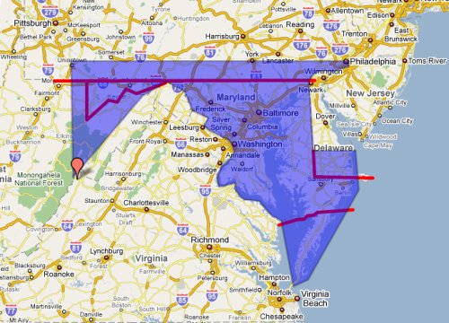
North: Maryland’s original northern boundary was supposed to be 40th parallel, however that turned out to run smack through the middle of Philadelphia, Pennsylvania’s most important city. So the boundary was negotiated south.
West: Maryland’s southern boundary has always been the Potomac River, but near Maryland’s narrowest point around the town of Hancock, the river splits into north and south branches. The south branch is bigger and so should have been the boundary, but historically the north branch served, and by the time anybody noticed the wrong branch had been picked, it was too late.
East: Delaware, small as it is, was supposed to be a lot smaller. The MD/DE boundary was intended to be the tip of Cape Henlopen, but alas, when the official map was being drawn prior to the revolution, Maryland’s Governor at the time mis-identified the cape as considerably more south, and Maryland lost Rehoboth, Bethany and Dewey.
South: Maryland was originally given control of the entire Eastern Shore south of Delaware, but by the time the Maryland colony got set up, the older Virginia colony had already granted lands to colonists on southern tip of the Eastern Shore, so Virginia succeeded in having the British crown change the boundary.
Sound interesting? You can read more about Maryland’s geographic history, and that of the other 49 states, in Mark Stein’s excellent book How The States Got Their Shapes.
Average Rating: 5 out of 5 based on 189 user reviews.
August 12th, 2009 | Permalink
Tags: history
|
Media


Site
About BeyondDC
Archive 2003-06
Contact
Category Tags:
Partners
|


