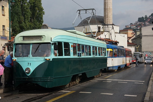
In the late 1950s and early '60s, as Washington's original streetcar system slowly converted its rail lines to buses, owners sold or gave away nearly 200 of DC's best railcars to any city that would take them. Those cars ran for decades all over the world. But time takes its toll, and today only one remains in anything like active service: Car #71 in Sarajevo, Bosnia and Herzegovina.
The last old DC Transit streetcar still in service, in Sarajevo. Image by Fototak on Flickr, used with permission.
Sarajevo took a total of 71 PCC streetcars from DC between 1958 and 1962, running most of then until the late '70s. Fascinatingly Sarajevo's transit company combined some of the streetcars into longer articulated ones, and ran them as double units. They may have been the only PCC cars to ever become articulated.
By the 1980s most of Sarajevo's DC railcars were retired. But one, car #71, has remained in service, sort of. It survived the brutal 1990s Siege of Sarajevo, and remains part of the tram fleet today, as a vintage model.
It doesn't run every day, nor even most days. But it's still brought onto the streets to carry passengers during special events.
It's the only remaining vintage DC streetcar that ever carries actual transit passengers.
For the record, San Francisco's Market Street Railway has a car painted to look like an old DC streetcar, but beneath its paint the railcar itself ran in Minneapolis and New Jersey.
What happened to the rest?
Prior to the sell-off, DC Transit, the streetcar operator of the late '50s and early '60s, owned 450 railcars.
Barcelona, Spain took 101 of them, and ran them until 1971. None of those remain in service, but four remain in museums or private collections.
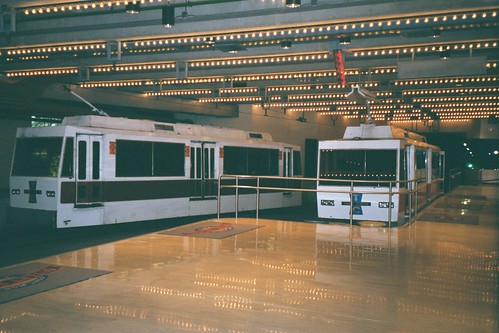
15 of them went to America's only private subway system, the Tandy Center Subway in Fort Worth, Texas. Their new owners modernized the cars and ran them until the subway ended service in 2002. One of those 15 old streetcars went to the McKinney heritage streetcar line in Dallas where it ran until 2006, when mechanical and electrical problems forced it out of service.
Three more of the Fort Worth railcars still exist. A group working to start a Texas transportation museum owns them, and hopes to use them as exhibits.
Former DC Transit streetcars running in the Tandy Center Subway in 2002. Image by Justin Smith on Flickr, licensed under Creative Commons.
Thirteen other DC Transit streetcars remain in museums around the United States.
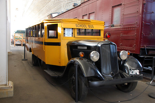
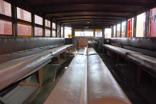
If you were an elementary school student the 1930s, this Dodge school bus might have been your ride. It carried students in Salem and Roanoke County, Virginia.
Check out the inside, with its child-sized benches and aisles. Who wouldn’t want to face the middle, or lean back against another kid?
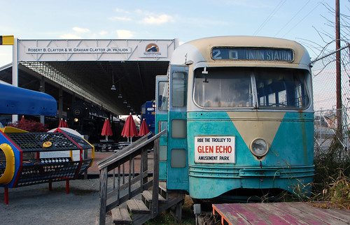
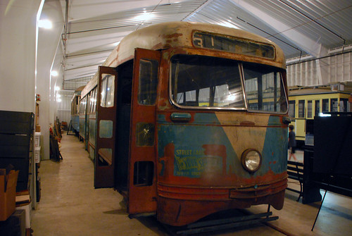
The bus is on display at the Virginia Museum of Transportation in Roanoke. The museum’s fascinating collection also includes this vintage 1945 streetcar from DC Transit. It ran on line 20, from Union Station to Glen Echo.
Jane Jacobs was born May 4, 1916, 100 years ago today. She left the world in 2006, but in her 89 years of life she revolutionized how we think about cities. Here is what GGWash contributors said about Jane, the patron saint of American urbanism.
Today’s Google Doodle honors Jane. Image from Google.
Jane’s most famous book, The Death and Life of Great American Cities, is required reading for anyone interested in the form of cities. It’s helped generations of Americans understand what makes places like Georgetown so pleasant, and places like Boston’s City Hall so repulsive.
Even 55 years after its publication, urbanists continue to obsess over Death and Life, debating obscure passages like clerics feuding over a religious text.
Ben Ross went straight to the point, then warned of the next great problem afflicting our cities:
Jane Jacobs was a true genius who developed a new paradigm of city planning. Our best city neighborhoods now suffer from the “curse of success” that she foresaw as the consequence of a scarcity of urbanism. How to overcome that scarcity is a problem that she left to us.
Canaan Merchant summarized two big lessons Jane taught him:
Look at what is actually happening rather than relying on what is “supposed” to happen. A city’s beauty lies in its people rather than its buildings. Bring the people out and the buildings will take care of themselves.
Former contributor Abigail Zenner focused on how Jane successfully communicated ideas:
She introduced many people to the world of planning and gave us words to describe what we see every day in cities but have a hard time explaining in simple language. She was able to make a case that stirred peoples’ hearts.
Nick Finio took a contrarian position, quoting a 1998 critique of Death and Life from UC Berkeley professor Roger Montgomery:
Let’s not glorify her too much. Montgomery’s critique ends with this zinger: “Taken together, these themes do add up. Anti-government and anti-regulation beliefs, confidence in the existence of a nearly perfect competitive market, inattention to corporate power, denial of social class and race as determinative categories, taken together look mighty like the core belief system of liberatarian conservatism.”
But other contributors were quick to jump to Jacobs’ defense. They pointed out that while her views may not be a perfect guide to urban issues today, her work helped surface notions that needed to come to the fore, like defending the idea of the city against car-oriented places, and eyes on the street maintaining safety.
Jonathan Krall added:
Just because Jacobs had a healthy mistrust for government and for large projects doesn’t mean she was espousing neo-conservatism. I agree with Montgomery that Jacobs’ excellent and helpful descriptions of healthy city life and associated planning issues skip over some very challenging social and political issues. However, I disagree with his implication that Jacobs is suggesting her readers should ignore those challenges.
Payton Chung opined on Jacobs’ motivations:
Just like any “bible, ” there are bound to be contrary readings. There’s a fine line between libertarianism and anarchism, and I’d argue Jacobs’ overall oeuvre points to a mistrust of all large institutions, whether corporate or governmental.
When all was said and done, it may have been Brendan Casey who summed Jane up best:
The force was strong with that one.
What do you think of Jane, and of her impact on cities?
This amazing map from 1861 shows a federal government proposal to redraw the borders of Maryland, Virginia, Delaware, and DC. The reason: To spite Virginia for the Civil War and better-protect the capital from attack.
1861 proposal to redraw the borders of Maryland, Virginia, Delaware, and DC. Image by Harper’s Weekly.
This arrangement would reduce the size of the State of Virginia at least one-half, leaving the name of Virginia to that part only which is now mainly loyal.
The disloyal section, comprising all the great cities of Virginia—Richmond, Norfolk, Fredericksburg, Lynchburg, etc.—and all the sea-coast, would be annexed to Maryland, while Delaware would rise, by spreading over the whole peninsula between the Chesapeake and the ocean, to be a State of considerable magnitude.
Under this reconstruction Maryland would become one of the three great States of the Union. We need hardly direct attention to the clause in the Secretary’s report which hints that emancipation in Maryland must be the price paid for this acquisition of territory.
Alexandria and Arlington would have returned to DC, which would have remained independent of any state.
When Cameron came up with his idea, the Civil War was less than a year old. The western more rural portions of Virginia had hoped to remain in the Union, while the more urban eastern portions had voted overwhelmingly to secede. In theory, this proposal therefore would have accomplished several goals. It would have:
1. Separated off the loyalist western parts of Virginia, allowing them to be reintroduced to the Union as a northern state.
2. Punished eastern Virginia, the intellectual and economic heart of the Confederacy, by taking away its independence as a state.
3. Rewarded Maryland and Delaware for remaining in the Union.
4. Protected Washington from having a hostile territory directly across the Potomac.
It’s not as crazy as it seems
In 1861, as Cameron was making this proposal, West Virginia was already in the process of splitting off from Virginia to become its own state. How exactly to draw its borders and what to call it was a perfectly reasonable question.
The most doubtful part of this idea is the notion that new-and-bigger Maryland would be a safe northern state. Although Maryland never seceded, it was a slave state and its loyalty to the Union during the Civil War was tenuous at best.
Adding the wealthy and populous parts of Virginia to Maryland seems more likely to have drawn Maryland towards the south than vice versa. Presumably that’s why the deal would have required Maryland to free its slaves.
Of course as we all know, this proposal didn’t work out. West Virginia’s boundaries and name became official in 1863 when it was admitted to the Union as its own state, and Virginia was itself readmitted in 1870 following four brutal years of Civil War.
But it’s interesting to look back and see what could have happened, had history turned out just a little bit differently.
In 1912 Baltimore’s city leaders hoped to annex this large chunk of Baltimore County. Had that happened, the city limits would have extended from just shy of downtown Towson to just shy of Ellicott City.
Image from the State of Maryland.
Baltimore annexed big chunks of land in three successive waves: One in 1817 that took the city as far as North Avenue, a second in 1888 up to about 40th Street, and a third in the early years of the 20th Century.
Like other US cities, Baltimore was expanding rapidly in the early 20th Century amidst a wave of streetcar-induced sprawl. Suburban areas lacked city services like sewers, parks, and police, so central cities often annexed surrounding land.
By about 1910, Baltimore was ready for another round of annexation. Exactly how much land the city should annex became a major hot-button issue of the day, with proposals ranging from no expansion to the aggressive, far-ranging one pictured above.
In 1918 a compromise plan eventually won out, settling Baltimore’s boundaries at their current extents.
By the time America’s post-World War II suburbanization boom happened, the national mood had shifted against central cities. A 1948 amendment to Maryland’s state constitution outlawed any further expansion of Baltimore city, and thus the borders haven’t changed since.
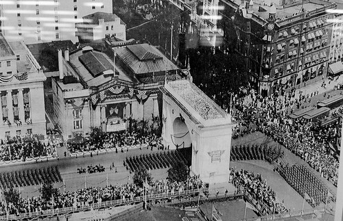
Paris’s Arc de Triomphe is world famous, but did you know DC once had its own version?
Photo from the DC Public Library.
The Washington, DC Victory Arch sat on Pennsylvania Avenue, at the corner of New York Avenue and 15th Street NW.
It was a temporary structure built to commemorate the end of World War I. This photo, from 1919, shows the US Army on parade following the end of the war. Presumably the arch was made of plaster, like the White City of Chicago, and thus never intended to be permanent.
In the mid 1970s, Metro’s first stations were under construction and on track for their 1976 opening day. This historic photo shows Metro Center station while it was under construction, circa 1975.
Metro Center circa 1975. Photo source unknown.
In the photo, the basic form of the station is in place. The vault is done, the track bed looks good, and the station’s lights are on. But there’s clearly a lot of work left to do, including most of the finishing touches.
It’s an interesting 40-year-old look at one of our region’s most important transit hubs.
On December 5, 1951, the world’s first “park-o-mat” driverless parking garage opened on K Street NW, between 14th and 15th Streets. The building doesn’t exist anymore, but this newsreel is a neat look into one of history’s previous attempts at driverless transportation.
The original park-o-mat buildling was just 25 feet by 40 feet, but at 16 floors and with two elevators, it had room for 72 cars.
As downtown DC developed and the city’s height limit began to limit land availability, property values eventually made it impractical to keep using this building as parking. Today, a a normal building full of people replaces it.
But automated parking does still exist. At least one apartment building in DC, the Camden Grand Parc, has an automated garage. And New York’s first “robotic” parking garage opened in 2007.
WMATA adopted its initial plan for the Metrorail system in 1968. Between then and the beginning of construction in 1969, the agency published this brochure, to teach people about the coming system.
WMATA 1968 brochure. All photos from Reddit user Globalwrath.
Reddit user Globalwrath discovered the brochure, and it’s a fascinating trove of historic thinking.
The last benefit on this page sounds suspiciously like sprawl.
Note future options for suburban extensions in virtually every direction, and a subway under Columbia Pike in Arlington.
“The Metro will be among the best in the world.” And it was, when it was new.
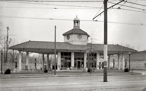
Most gas stations these days are pretty garish, but gas stations weren’t always so. Check out this vintage 1924 station, from Connecticut Avenue in Woodley Park.
Lord Baltimore Filling Station. Photo by the National Photo Company, via the Library of Congress.
This is the Lord Baltimore Filling Station, at the corner of Connecticut Avenue and Ordway Street NW. It may not be truly typical of the era, but it’s hard to imagine seeing as sharp-looking a gas station today.
It’s not only the nice architecture that make this notable. It’s also the urban design. This isn’t as great for sidewalk life as a row of main street-style shops, but it’s a building that fronts on the sidewalk. It could be a lot worse.
Do you know of any unusually good-looking gas stations? What makes them interesting?


 Comment on this at the version cross-posted to Greater Greater Washington.