Sochi’s main Olympic Village is 20 miles southeast from downtown Sochi, near the city’s airport. It’s home to the athlete residences, stadiums for the indoor sports, a theme park, and a huge rail station. The venues for mountain sports are 35 miles inland, near Krasnaya Polyana.
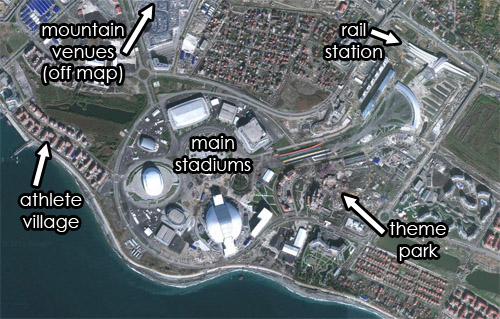
Satellite view of Sochi’s Olympic Village. Original image from Google.
Average Rating: 4.4 out of 5 based on 272 user reviews.
February 10th, 2014 | Permalink
Tags: land use, maps, parks
Well, this is embarrassing.
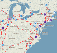
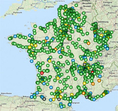
Using Amtrak’s real-time train tracker and the French equivalent, one can see the number of trains operating in each country at any given time. Putting them side-by-side isn’t a pretty sight.
It’s not quite as bad as it looks at first glance, because at this map scale Amtrak’s tracker clusters bunches of nearby trains into a single purple-colored dot. So there are admittedly a lot more trains in the Northeast and near Chicago than appear individually here.
On the other hand, Amtrak’s map shows all trains, while the French version is only showing regular speed ones. For high speed trains there’s a separate map.
Average Rating: 4.6 out of 5 based on 194 user reviews.
February 6th, 2014 | Permalink
Tags: intercity, maps, transportation
Should potential future streetcars on Georgia Avenue have dedicated lanes? DDOT is hosting a series of public meetings this month to help plan that route. The meetings will be a good opportunity to voice support for dedicating street space to transit.

The North-South Corridor, including 16th Street, 14th Street, and Georgia Avenue.
Image from DDOT.
DDOT’s North-South Corridor will run from somewhere near the baseball stadium north to either Takoma or Silver Spring, right through the heart of Mid City DC. Planners are still working on the exact route, but the line will probably run on some combination of Georgia Avenue and 14th Street. It could also be a bus or a streetcar.
One big question is whether it will have any dedicated lanes. If you think it should, it’s important to attend one of the meetings and communicate that to DDOT.
The meetings are:
- Tuesday, Feburary 18
3:30-8:00 pm (presentations at 4:00 and 7:00 pm)
DCRA, 1100 4th Street SW
- Wednesday, February 19
10:00 am – 12:00 pm
MLK Library, 901 G Street NW
- Wednesday, February 19
3:30-8:00 pm (presentations at 4:00 and 7:00 pm)
Banneker Rec Center, 2500 Georgia Avenue NW
- Thursday, Feburary 20
3:30-8:00 pm (presentations at 4:00 and 7:00 pm)
Emery Rec Center, 5701 Georgia Avenue NW
There are many benefits to streetcars regardless of whether they have dedicated lanes or not. But giving them lanes absolutely increases their usefulness, especially in a corridor with such high transit demand.
As part of any good corridor planning, it’s important to figure out where dedicating space makes the most sense. It’s also a good time to advocate for terminating the line at Silver Spring, where there are more potential riders than at Takoma. This is exactly the time and place for transit activists to show up.
 Cross-posted at Greater Greater Washington.
Average Rating: 4.4 out of 5 based on 277 user reviews.
February 5th, 2014 | Permalink
Tags: streetcar, transportation
|

Photo from thisisbossi on flickr. |
Harriet Tregoning, Director of the DC Office of Planning, is resigning to take a job in the Obama administration as the Director of the HUD Office of Sustainable Housing and Communities.
The nation’s gain is DC’s loss. Tregoning has been one of the strongest regional voices for urbanism, transit, and smart growth.
With Arlington’s Chris Zimmerman also leaving local government this month, DC-area urbanists have big shoes to fill indeed.
Average Rating: 4.9 out of 5 based on 168 user reviews.
February 4th, 2014 | Permalink
Tags: government, people
This map, from the American Intercity Bus Riders Association, attempts to show all the major intercity transit routes in America. It includes Amtrak, Greyhound, and several other bus carriers.
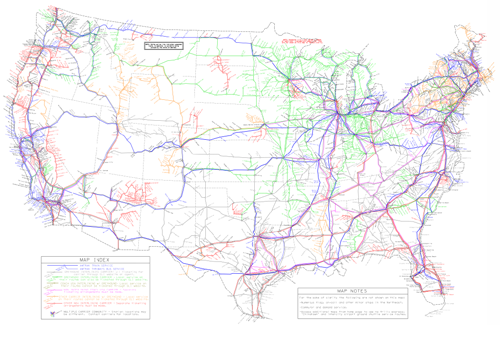
Map of Amtrak and intercity bus lines, from AIBRA.
It’s probably impossible for this kind of map to be 100% accurate all the time. In all likelihood there are some missing links, and missing carriers. But it’s still quite an impressive undertaking, and a useful tool to bookmark.
Cross-posted at Greater Greater Washington.
Average Rating: 4.9 out of 5 based on 270 user reviews.
February 3rd, 2014 | Permalink
Tags: intercity, maps, transportation