|
Special Features


Image Libraries


|
|
Blog
Ryan Avent offers this thought experiment:
“Divide the District into two areas: the [downtown] zones (CBD, NoMa, Ballpark), and the rest. In each area, all limits on height will be eliminated. In their place, the city will level a “floor tax”; a developer can build as high as he or she likes, but must pay a one-time fee for each floor-equivalent (say, for each 10′ of height) above the currently existing development limits. This is not in lieu of other city taxes, which would still be paid; the city would basically be selling height permits. So downtown, a developer could tear down a 13-floor building and replace it with a 20-floor building, provided that it paid the floor tax for each of the 7 floors above the previous height. In Brookland, a developer could build an 8-floor building on land currently zoned for 2-story construction, provided it paid the floor tax on the 6 additional floors.”
“My question is: where would you, urbanists and District residents, set the two tax rates (one for the office zones, one for the rest of the city)? You’re not allowed to reject the system out of hand; given that this policy will be put in place, but given the freedom to set the tax rates however you like, which rates would you choose?”
I’m not opposed to talking in terms of this kind of model, provided we adequately price things that aren’t usually adequately priced, but the model Ryan proposes is too simple in at least three ways:
- Metro stations matter. Two geographic zones is not enough. At least three are needed: One for downtown, a second for outer areas near Metro stations, and a third for the rest. Really even more than that are probably necessary, but I can’t see taking this discussion at all seriously without at least those three.
- Land use matters. Ryan doesn’t care if new construction is residential or commercial, but I do. I want to incentivize different land uses in different areas, so I want a model that takes land use into account. There should be options to apply a different tax rate to different land uses.
- Other buildings matter. Cities without height limits (or with limited ones) often see a handful of very tall buildings surrounded by empty or dramatically underused lots. Any model to allow taller buildings in Washington should be structured in a manner that reduces the likelihood of this happening. This would be possible (but cumbersome) to do under Ryan’s proposed model by adjusting the extra floor tax rate based on the height of buildings on all properties with a certain radius, say 3 blocks. For example, the tax rate to build extra floors would be much higher if there’s a parking lot across the street than if there’s a bunch of 12 story buildings, because we really don’t want that empty lot to stay empty.
So with a more sophisticated model in hand, what’s our goal for the city? The purpose of any regulatory tool is to produce results, so let’s identify the desired results. My vision for the city is that it be filled with mixed-use neighborhoods (of which downtown is one) that are active 18 hours a day, rather than being single-use ghettos for offices or bedroom communities. I want the most intense uses to be within walking distance of Metro stations and closer to the regional core. Within the more intense areas, I want bustling sidewalks that are pedestrian friendly and devoid of empty spaces. I want a variety of old and new architecture, and do not want large areas to be visually banal or identical. I want to guarantee that our special national symbols are not overwhelmed by common buildings, and that we enhance our public spaces.
So how can we structure Ryan’s model (with my additions) to result in the city I want? Here’s one possibility, structured to encourage residential development downtown, both residential and office development in the outer Metro station areas, and neither in the outer non-Metro areas:
| |
Downtown |
Outer Metro |
Outer Non-Metro |
| Office |
High tax rate |
Low tax rate |
High tax rate |
| Residential |
Low tax rate |
Low tax rate |
High tax rate |
Concern number 3 from above would still be an issue, so this table would only be the base tax rate, which would have to be adjusted according to the height of buildings on nearby properties. I want to minimize the number of empty lots all over the city, so any time there are empty lots nearby (or perhaps even lots with particularly short buildings) the tax rate would climb, to disincentivize land banking. The adjustment formula would also vary depending on the zone, because I have unique goals for each area. For example, in downtown I want to preserve views of some of the monuments, so proximity to those monuments would trigger a much higher tax rate.
Where to actually set the numbers is a question that would require a lot more study. I’m not comfortable making specific suggestions without knowing just how much of an incentive or disincentive certain rates would be to potential developers. What rate do I need to make adding a few residential floors to new buildings downtown too good to pass up? What rate do I need to allow a handful of 50-story downtown skyscrapers for the people who really feel they need them, but not so many that it saps demand away for office development in Tenleytown and Silver Spring? Until we have answers to those questions, we can’t be expected to set rates. But I do think Ryan’s model – or a much more sophisticated version of it – could potentially be a happy compromise to the height limit issue.
Average Rating: 4.6 out of 5 based on 210 user reviews.
April 6th, 2011 | Permalink
Tags: proposal, urbandesign

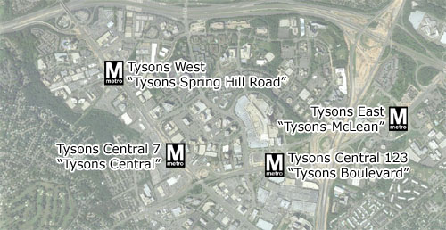
What do Gallery Place, Van Ness, and White Flint all have in common? Originally they were mere Metro station names, but since being introduced they have all transcended to become the names of entire neighborhoods.
What do Tysons-McLean, Tysons I & II, Tysons Central, and Tysons-Spring Hill Road have in common? They are proposed Metro station names that will never, ever do the same. Maybe if people drop the “Tysons” part of each name and just use the second half colloquially, but even then it’s hard to imagine anyone calling a neighborhood “I&II”.
Yesterday, Fairfax County’s Board of Supervisors approved its recommendations for the 8 new Metro stations that will open in Fairfax as part of the Silver Line. The names are, in a word, terrible. The four stations in Tysons Corner are particularly unfortunate, because the county is engaged in a long term plan to remake Tysons as an urban center. Suburban park and rides might not need distinctive names, but urban neighborhoods do, and in this way Fairfax is utterly failing its own agenda for Tysons Corner.
I’ve discussed this before, as has GGW, but the proposed names for Tysons are so mind-bogglingly bad that they really do merit response.
What sort of names might better define the urban neighborhoods Fairfax hopes to create in Tysons Corner? How about any of the following, all named after neighborhoods, parks, or roads in the vicinity of the proposed stations:
| Fairfax Proposal |
Better Option 1 |
Better Option 2 |
Better Option 3 |
| Tysons-McLean |
Scott Run |
Dolly Madison |
Pimmit Hills |
| Tysons I&II |
Galleria Center |
Tysons Market |
International Center |
| Tysons Central |
Westpark |
Solutions Center |
Gosnell |
| Tysons-Spring Hill Road |
Spring Hill |
Raglan Park |
Ash Grove |
The good news is the WMATA Board has ultimate say over what these stations will be called, so there is still hope that they will ignore Fairfax’s recommendations in favor of station names that will convey some sense of place to the neighborhoods that are sure to grow around them.
But how likely is WMATA to overturn a local decision? And really, why should they? It’s not the Metro Board’s job to fix Tysons Corner.
Average Rating: 4.7 out of 5 based on 277 user reviews.
March 30th, 2011 | Permalink
Tags: government, metrorail, proposal, transportation
Arlington is moving forward with streetcar plans for Columbia Pike and Route 1. How might the trains be branded once they start running?
It seems unlikely they’ll be branded as Metro. What are the options? I created some potential concepts in Photoshop. These are not official branding proposals, just my own ideas for discussion.
DC has a unified Circulator/streetcar branding scheme. What about the same for Arlington Transit? ART’s wavy green livery is clean and unique. Extended to a streetcar, it might look like this:
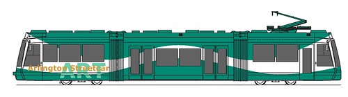
Click all streetcar images to enlarge.
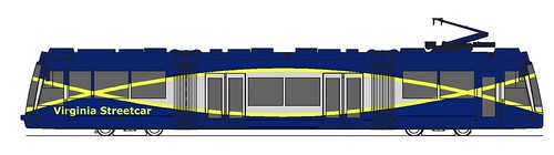
Pretty nice, but it probably won’t happen that way. After all, both the Columbia Pike and Route 1 lines will extend into other jurisdictions. Fairfax and Alexandria might not like their streetcars branded as part of ART.
How about mimicking the DC streetcar, so as to give the impression of a unified regional system. Starting with that paint scheme but substituting the red from DC’s flag with blue from Virginia’s, a streetcar might look like this:
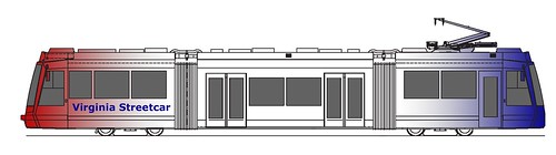
That could work, but it’s certainly not the only option. There’s no reason Virginia streetcars need to be branded like anything currently out there. There are endless permutations. Here’s another:
In fact, streetcars don’t necessarily need special branding at all. The mere fact that they’re streetcars may be branding enough. Portland and Seattle each use a variety of solid colors, and it works just fine. Applied to Virginia, that might look something like this:
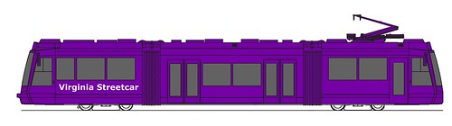
So there are a ton of options. What do you think the powers that be should consider?
 Cross-posted at Greater Greater Washington. Cross-posted at Greater Greater Washington.
Average Rating: 4.6 out of 5 based on 266 user reviews.
February 22nd, 2011 | Permalink
Tags: fun, galleries, proposal, streetcar, transportation
|
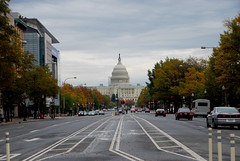
Should Pennsylvania Avenue be renamed? |
Now here is a ballsy idea, courtesy DC at-large council member Michael Brown:
The D.C. Council is considering a name change for the stretch of Pennsylvania Avenue between the 1300 and 1400 block. The change would reflect the city’s ongoing quest for statehood.
This is too hilarious to pass up. Reasonable compromise has failed us, so why not try the crazy approach? Let’s use what tools the city has at its disposal to draw attention to the shame on democracy that is DC’s lack of representation.
My only complaint is that we’re limiting the proposal to the 1300 block. If we really wanted to stick it to the feds we’d rename the whole stretch between the White House and Capitol, or at least the 1600 block (the White House is at 1600 Pennsylvania).
Here are some naming ideas:
- Taxation Without Representation Avenue
- Embarrassment To Democracy Avenue
- Partisanship Before Values Avenue
- Second Class Citizens Avenue
- 600, 000 Americans Who Don’t Count Avenue
Who can think of something better?
Average Rating: 5 out of 5 based on 269 user reviews.
January 13th, 2011 | Permalink
Tags: fun, government, proposal, roads/cars, transportation
|

Matt’s proposal for three-letter station codes. |
Matt Johnson has an interesting post up at Greater Greater Washington proposing three-letter abbreviations for Metro stations, in the tradition of airport codes. The idea is that instead of writing out “U Street/African-Amer Civil War Memorial/Cardozo”, you’d just go with “UST” and everyone would know what you meant. The post was in response to a suggestion that he and I consider such a code system, so I may as well share my thoughts too.
Matt and I talked about it a bit on Twitter and then went separate ways. He wanted to try three-letter codes and I wanted to try two-letter ones. I never got around to putting my codes onto a map, but they’re available in spreadsheet form. Like Matt, I developed some guidelines. They were:
- If the station name is two words, use the first letter of each word.
- If the station name is one word, use either the first and last letter, the first letters of each syllable, the first and second letter, or (in rare cases) the first letter plus a vowel or consonant that stands out for some reason.
- Focus on the common names for the stations, not the long official names.
- No duplication of codes. When duplicates appear, change both of them to avoid confusion (so no one wonders if CH is Court House, Columbia Heights, Congress Heights, or Capitol Heights).
Ultimately, that last ‘no duplication’ rule proved the biggest problem, and the biggest reason why I think Matt’s three-letter system is superior. It isn’t just that there are four CH stations. BR, CP, MC, and US all show up more than once, requiring more than ten stations to have non-intuitive codes. That just won’t do when there’s a perfectly good three-letter alternative available.
Having come around to Matt’s point of view on the number of letters, what about his specific proposals? I think most of them are spot on, but there are a handful I’d change, generally because I think they could be more intuitive with regards to which consonant sounds are dominant. For example: RVL for Rockville, GVR for Grosvenor, FSH for Friendship Heights, and GLN for Glenmont.
But really, nitpicks aside, I like it.
Average Rating: 4.8 out of 5 based on 251 user reviews.
January 12th, 2011 | Permalink
Tags: fun, metrorail, proposal, transportation
Throughout the planning stages of the Silver Line, the four Metro stations in Tysons Corner have been designated by purely descriptive names. Now that construction is well under way, it’s time to consider what those stations should permanently be called. Metro station names have a way of defining their neighborhoods, so it’s an important question.
The Fairfax County Department of Transportation proposes this:
Original descriptive names on top, proposed new names on bottom in quotes.
Tysons East would become “Tysons-McLean”, Central 123 would become “Tysons Boulevard”, Central 7 would be “Tysons Central”, and Tysons West would be “Tysons Spring Hill”.
As the Washington Post notes, the new proposed names are certainly better than the originals, but they lack a certain catchiness. They’re headed in the right direction, but attaching the word “Tysons” in front of every single one makes them all seem overly contrived. These still seem more like manufactured descriptive terms than the names of real places.
Can we do better? The new names won’t be officially adopted until some time in 2011, so there’s plenty of time to influence the process.
One option might be to simplify Fairfax’s suggestions so they roll off the tongue a little easier: “McLean”, “Tysons Boulevard”, “Tysons Central”, and “Spring Hill Road”. Another option might be to take my suggestions from 2008 and go with “Scott Run”, “Galleria Center”, “Westpark”, and “Spring Hill”.
Or maybe there are even better ideas floating out there. What do you think?
Cross-posted at Greater Greater Washington.
Average Rating: 4.5 out of 5 based on 293 user reviews.
October 21st, 2010 | Permalink
Tags: metrorail, proposal, transportation
Rumor has it that the owner of the Washington Wizards is considering changing the name of the team back to the Bullets. As long as we’re thinking about new names anyway, how about this:
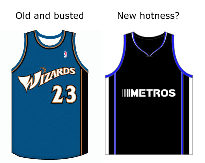
I’m only sort of serious.
“Metros” (or should it be “Metroes”?) uniform created using JerseyRack.com.
Average Rating: 4.5 out of 5 based on 208 user reviews.
October 14th, 2010 | Permalink
Tags: fun, proposal
Scott Circle is the worst of downtown’s five main roundabouts. The roads are a hostile mess that pedestrians avoid at all costs, and the green spaces are chopped into such small and disconnected fragments that there’s not a useful park among them. There isn’t even a single marked crosswalk leading in to the circle itself.
In it’s current form Scott Circle is essentially a piece of highway infrastructure plopped in the middle of a walking city. It’s got to go. Luckily, there’s a workable model for what to do with it just a short way down the street.
Mount Vernon Square Lincoln Park in Capitol Hill offers a potential solution. Rather than allowing all the converging streets to cut through the park, auto traffic is routed around the square, as if the whole thing were a rectangular-shaped roundabout.
Theoretically, the same could be accomplished at Scott Circle like so:
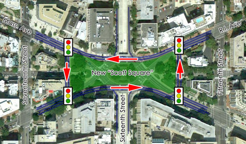
Arrows indicate direction of traffic.
DDOT would need to introduce new stop lights, and yes, auto traffic might be slowed somewhat. But in return the city would receive a new park space that could potentially be larger than any of the circles. At the very least, Scott Circle should not be so dangerous and inhospitable for pedestrians. At best, with the right programming and a little luck, we might construct a space as elegant and loved as Dupont Circle.
Cross-posted at Greater Greater Washington.
Average Rating: 4.8 out of 5 based on 260 user reviews.
October 13th, 2010 | Permalink
Tags: proposal, roads/cars, transportation, urbandesign
Imagine this: A driver in his car approaches a traffic light in downtown Washington. The light is green, so the driver crosses into the intersection but can’t make it all the way across before being forced to stop behind a line of other cars. Before the driver can move through the intersection, the light changes to red. Now he is blocking cross traffic from moving through the intersection in the perpendicular direction.
Anyone who has ever driven, bicycled or walked around downtown Washington at rush hour knows that the scenario described above is replayed in real life thousands of times a day. Drivers routinely “block the box” by inching into a crowded intersection when they have a green light, and then staying there once their light turns red, blocking cross traffic. The practice is tantamount to running a red light, and it is a major contributor to auto and bus gridlock downtown during rush hour.
But it doesn’t have to be that way. We already have red light cameras at multiple locations throughout the city. Why not roll out a hundred more downtown? Block a box? Snap! Picture taken, your ticket is in the mail. Once ticketing became common, it’s logical that blocking the box would not be such a widespread crime.
Any time someone suggests anything that reduces drivers’ sense of entitlement, such as ticketing drivers who break the law, apologists come out of the woodwork to fight the proposal. But in this case, increased ticketing of drivers who block the box would serve to directly improve traffic flow. Unlike cameras aimed at reducing speed or generating income, cameras aimed to primarily ticket box blockers would benefit all other drivers in the city by virtue of reducing congestion. Bus riders, cyclists and pedestrians would benefit as well, since they suffer as much from gridlock and blocked cross walks as anyone.
Increased red light cameras downtown aimed at ticketing box blockers seems like it would benefit everyone, including the majority of drivers, without harming anyone except those who choose to break the law and make congestion worse. Why not do it?
Cross-posted at Greater Greater Washington.
Average Rating: 4.4 out of 5 based on 159 user reviews.
September 8th, 2010 | Permalink
Tags: proposal, roads/cars, transportation
|
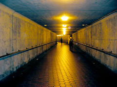
Why not add murals to this tunnel at Court House Metro? |
One of the most basic tenets of good urban design is that walkways should be lined with things to look at. Blank walls discourage walking because they make a walk seem boring and therefore longer, and because empty and lightly maintained spaces feel less safe. Detailed, colorful places are inherently more pedestrian friendly than dismal, blank spaces, and therefore urbanistically superior.
So, given that, why do we accept so many blank spaces in our cities?
Take a look at the photo at right. It shows a walkway under Wilson Boulevard leading to Court House Metro station. The walkway isn’t much longer than the street is wide, but walking through it is a pretty dismal experience. It feels like such a long and dangerous walk that few people use the tunnel. Sprucing it up would almost certainly increase usage, and could potentially lead to higher Metro ridership. Better lighting and some mirrors would help, of course, but what about a little art? Why not cover each wall with a series of colorful murals?
There is no need for any such project to be expensive or logistically challenging. Every high school in America is filled with art students who would love a chance to show off their skills publicly. Metro could work out a deal with a local school: Give each art student one concrete panel and let them go wild, as part of a class project. Coordinate with teachers to make sure murals turn out appropriate to the public (and if one doesn’t, 10 minutes and a bucket of white paint solve that problem). For practically no cost, Metro would dramatically improve the user experience at this station. If it leads to even a modest rider increase, the project would pay for itself.
How many other places around the region would benefit from a similar project? Any city resident can probably think of 10 blank walls somewhere in their neighborhood. It seems the only reason they can’t be improved is that nobody bothers to do so.
Of course it is true that Metro and the city at large have bigger problems than a few blank walls, but this is low-hanging fruit. It will take long, hard work to solve Metro’s systemic maintenance and safety problems, but this is something that would positively influence the system and could be accomplished with nothing but a few hours of coordination and the cost of paint.
Let’s do it.
Cross-posted at Greater Greater Washington.
Average Rating: 5 out of 5 based on 159 user reviews.
August 17th, 2010 | Permalink
Tags: proposal, urbandesign
|
Media


Site
About BeyondDC
Archive 2003-06
Contact
Category Tags:
Partners
|


