Mayor Bowser's latest DC budget proposal includes $165 million to replace the Hopscotch Bridge. Once a new bridge is open, an eyesore will become a prime public space, and long-awaited expansions of Union Station and DC Streetcar can finally happen.
Rendering of the new Hopscotch Bridge, surrounded by new development behind Union Station. Image by Akridge.
Today, Hopscotch Bridge carries H Street over the railroad tracks behind Union Station. In order to make room for trains to pass below, the bridge rises high above H Street's normal elevation. With solid walls and the Union Station parking garage on either side, the bridge is a three block long stretch of desolation, amid an otherwise vibrant part of the city.
Replacing the bridge will change that.
Existing Hopscotch Bridge. Image by Bossi licensed under Creative Commons.
A new bridge, designed specifically to accommodate buildings on either side, will make it possible to develop the air rights above Union Station's railyard, and to replace the parking garage with a new train hall. What was desolate will become a major new public space, with landmark architecture, a mix of uses, and a more open, European-style train hall.
Proposed H Street entrance to Union Station, as part of Burnham Place. Image by Akridge.
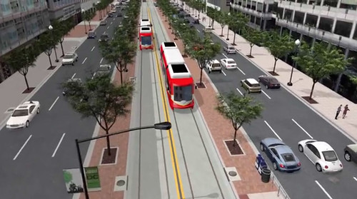
Streetcar can go downtown
Building a new Hopscotch Bridge also opens to door to finally extending the H Street Streetcar to downtown Washington and Georgetown. The streetcar doesn't specifically need a new bridge, but timing is an issue. DDOT doesn't want to extend the streetcar now only to rip up tracks and suspend service in a couple of years when the bridge is torn down and replaced anyway.
As it is, tearing down and replacing the existing bridge will mean temporarily removing the streetcar stop atop the bridge. That's bad enough, but it would be a much worse situation with streetcars running downtown.
When it runs downtown, DC Streetcar will have a dedicated transitway. Image by DDOT.
Budget details
Mayor Bowser's proposal would fund $165 million in 2019 and 2020. The DC Council will have to approve the budget before it becomes law. Even if it does, another $40 million would still be needed before construction could begin. That money would either come from other sources, or a future year's budget.
Once funding is fully in place and DDOT completes the final design, construction should take about two years.
Decade after decade, American metropolitan areas continue to widen their highways in order to reduce congestion. And decade after decade, congestion just keeps getting worse. That may be counterintuitive, but it’s because of a phenomenon called induced demand. This simple gif illustrates how it works:
Surely one more lane will finally solve our congestion problem, right? (Slightly better GIFF. Feel free to copy) pic.twitter.com/uDJwqVT3WI
Of course, it’s a little more complicated than this gif. Congestion keeps increasing not only because more people drive, but also because more people drive farther. And because the more highways we build, the less walkable and transit-accessible our cities usually become. And because the more desperate our congestion situation becomes, the more some groups attack using money for anything other than more highway widenings.
Highway congestion is a negative feedback loop. The only way to really solve it, besides economic calamity, is to break out of the loop by attacking its root causes. Rather than applying highway-widening band-aids that only work for a few years, build urban communities with multimodal infrastructure, in which it’s just as convenient (or more so!) for most residents to get around without a car than with one.
That doesn’t mean no new roads are ever needed. New communities and densifying ones need streets, after all. But it does mean we should be skeptical of plans to make highways bigger. In the long term, that money is usually better spent elsewhere.
Rockville Pike could one day become a 252-foot-wide mega boulevard with 12 car lanes, 4 bike lanes, 2 bus lanes, and over 50 feet of landscaping. But in designing a street with more than ample room for cars, bikes, and buses, planners abandon any hope the street will be walkable.
The plan for Rockville Pike. Image from Rockville.
Everybody gets a lane!
Rockville Pike is one the most important retail strip highways in the Washington region. Like most 20th Century retail roads, it’s designed for cars, and it carries a lot of them.
Rockville wants to make it a more urban main street, so planners there are drawing up a redevelopment plan. It’s a laudable goal, and it’s not easy on a high-traffic state highway like Rockville Pike.
At first glance, this plan has all the components of a good complete street design: Tree-lined sidwalks, protected bikeways, a center-running dedicated busway. Every mode gets all the street width it could possibly want.
And why not? Why go through the political headache of forcing the community to make the difficult choice between fewer car lanes versus bikes or BRT if you can fit everything in? With a mega boulevard like this, everybody gets what they want, and nobody loses. Right?
Wrong.
Walkability loses, and it’s the most important factor
At 252 feet wide, the new Rockville Pike will be practically impossible for pedestrians to cross. It will take multiple traffic light cycles and multiple minutes for anyone to cross.
Instead of a main street, Rockville will have a barrier. And that is a big problem for the rest of the plan.
Transit oriented development doesn’t work unless it’s walkable. If Rockville Pike is too wide, development on one side of the street will be effectively cut-off from development on the other side. Riders won’t be able to easily access the BRT stations. People will drive for even short trips. The concept of a community where people don’t need to drive everywhere will break down.
If you can’t walk, other multimodal options don’t work. Pedestrians are the linchpin to the whole thing.
To be sure, some level of compromise is always needed. If walkability were the only factor that mattered, all streets would be pedestrian-only. We add in car lanes, bike lanes, and transit because we have to make longer trips possible, and that’s a good thing.
But there’s a balance, and 252 feet veers so far to accommodate long distance travel that it seriously sacrifices short distance walking. In so doing, Rockville undermines the very foundation on which its redevelopment plans rest.
Make pedestrians a priority
The Pike needs to be narrower. Assuming the sidewalks, busway, and three general car lanes each direction are sacrosanct, that still leaves a lot of potential fat to trim.
Are the service roads really necessary if the plan also includes new parallel local streets? Do we really need redundant bi-direction bikeways next to both sidewalks? Could we possibly reduce the 74 feet of various landscaping, buffer, and turn lanes?
These would be difficult trade-offs, to be sure. But there are massive negative consequences to an uncrossable mega boulevard.
If Rockville wants the new Pike to work as multimodal urban place, pedestrians need to become a priority.
Traffic wasn’t nearly as bad as it could have been during Wednesday’s Metro shutdown. Telecommuters were a big reason why. That’s fine for a one-time event, but it won’t work every day.
Photo by Elvert Barnes on Flickr.
We don’t know exactly how many people telecommuted during the Metro shutdown, but the number was surely gigantic. Anecdotal evidence suggests there could have been hundreds of thousands of normal commuters who simply didn’t travel into their offices.
Obviously when you remove tens or hundreds of thousands of commuters from the daily rush, that helps a lot with traffic.
But it’s one thing for so many people to telecommute all at once because of a freak one-time event. It would be quite another to see those levels of telecommuting over and over, work day after work day.
When it’s just one day, you can reschedule your meetings, live without your physical files, and put off working with specialized equipment. For just one day it’s easy to focus on email and other things you can do from home.
But at some point, office workers have to go in to their offices. As technology improves, the day-to-day telecommuting rate may well increase, but at least for now it’s not going to be possible for so many people to make telecommuting an everyday option.
Workers can avoid rush hour travel in large numbers for a freak event, but not everyday. If our city didn’t have Metro, the daily commute would rapidly become much worse than what happened on Wednesday.
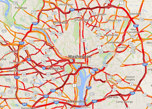
A lot of people had awful commutes last night, thanks to snow. And a lot of people had fine ones. One explanation for the difference: Suburban roads are far more susceptible to catastrophic breakdown than urban street grids.
Traffic congestion on snow night. Image from Google.
Snow storms like last night’s highlight how easy it is to completely shut down suburban-style transportation systems. And conversely, how comparatively resilient are more urban systems.
Cities beat suburban areas on snow resiliency in two big ways: Multimodalism and network connectivity.
First and foremost, with transit, walking, and biking more convenient options, cities are simply much less reliant on having clear roads. Metrorail worked like a dream yesterday, and pedestrians had a lovely commute.
It simply didn’t matter how bad the roads got for a significant percentage of DC’s travelers, because they simply weren’t on the roads while they traveled.
Don’t put all your eggs in one basket
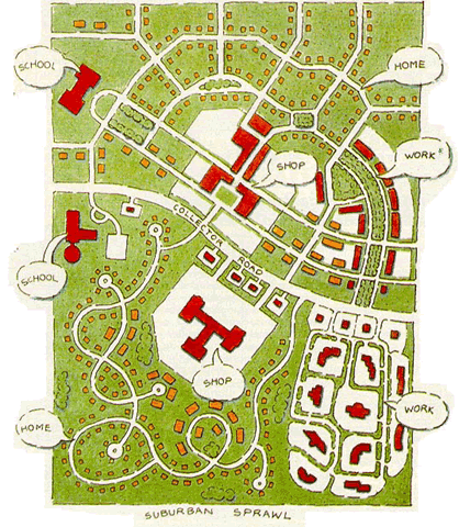
But that’s not all. Even for car drivers, urban street grids are more resilient than road systems focused around large highways, because of how they’re laid out.
The great thing about interconnected grids is that if one street becomes blocked, there’s another perfectly good street one block over. And another one block down.
If a wrecked car or fallen tree or whatever blocks the street you’re on, you just take a different street. There might be some additional turns involved; it might not be quite as direct. But for the most part 28th Street isn’t all the different from 29th Street.
Contrast that with suburban-style systems where all traffic in a particular area funnels onto one big highway. If that one highway becomes impassible, everyone in the area is stuck. Or, at best, they have to drive miles out of their way to find the next big highway.
This illustration shows how that works. If the “Collector Road” gets jammed, people in the top half of the image can still move around. People on the bottom half can’t.
Suburban-style roads vs urban street grid. Image from USDOT.
That’s part of what happened last night. There were a lot of crashes. If they happened on arterial highways with no parallel roads, which a lot of them did, that road would succumb to gridlock.
Urban places aren’t immune, but they’re better off
To be sure, this storm was bad for roads all over the region.
Streets in Northwest DC were just as dangerous as those elsewhere, and DC’s plowing response was bad. And buses were every bit as stuck in it as cars.
But there’s no doubt that people who could travel via Metro or foot had a much better time, and there’s no doubt that drivers who could use parallel streets were able to bypass some of the congestion on arterials.
On December 5, 1951, the world’s first “park-o-mat” driverless parking garage opened on K Street NW, between 14th and 15th Streets. The building doesn’t exist anymore, but this newsreel is a neat look into one of history’s previous attempts at driverless transportation.
The original park-o-mat buildling was just 25 feet by 40 feet, but at 16 floors and with two elevators, it had room for 72 cars.
As downtown DC developed and the city’s height limit began to limit land availability, property values eventually made it impractical to keep using this building as parking. Today, a a normal building full of people replaces it.
But automated parking does still exist. At least one apartment building in DC, the Camden Grand Parc, has an automated garage. And New York’s first “robotic” parking garage opened in 2007.
Have you ever seen a traffic safety campaign that reprimands you for not wearing bright colors every time you cross the street? Of course you have. Here’s video proof that’s a load of bollocks.
In this viral video, a careless SUV driver rolls into a neon-clad police officer. There’s no ambiguity as to who’s at fault. The officer was stopped still, in broad daylight, and wearing the holy grail of bright clothes: a reflective vest. The SUV driver simply didn’t stop when he or she should have. Thankfully it all happens at slow speed, so it doesn’t appear the officer was hurt.
But this is a clear illustration of why it’s wrong to lecture pedestrians about wearing bright colors. It’s not reasonable to demand that everyone wear bright yellow every time they’re outside a car. But it is absolutely reasonable to demand that drivers not carelessly drive into people, no matter what anyone is wearing.
A sporty coupe glides joyfully along a seaside highway, all by itself. It’s heaven for the anonymous driver. That’s the standard, ridiculous car commercial.
This video shows what car commercials would look like if they were actually honest.
Do you know of a safety problem on a DC street? If so, tell DDOT about it using the interactive Vision Zero map. It allows residents to click a location and type in notes to describe problems.
Image from DDOT.
This new map is part of DC’s Vision Zero Initiative, which aims to eliminate all fatalities and serious injuries in the transportation system.
The map lets you add notations for a wide variety of safety problems. There are separate categories for driver, pedestrian, and cyclist problems, with several options available for each. You can also scroll around DC to see what your neighbors have submitted.
It’s a neat tool. I’ve already submitted a handful of problems.


 Comment on this at the version cross-posted to Greater Greater Washington.