|
Special Features


Image Libraries


|
|
Blog
|
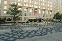
Vermont Avenue’s new “road tattoo”. Photo by DDOT. |
Vermont Avenue between H and I Streets is an unusual place. It’s so underused as a traffic thoroughfare and such a prestigious location close to the White House that it is becoming clear it may be better suited to a life as something other than a mere street.
Not only is this block of Vermont the very last block of the street, it’s an orphan – a segment disconnected from the main stretch of the road, and therefore used very sparingly by drivers. So sparingly in fact that when it closes for a farmer’s market once a week at the height of rush hour there is no noticeable effect on congestion. Even when this block is open to traffic it is clear that there’s a surplus of available street space, given that it has pavement-hogging diagonal on-street parking, something typical in small towns but rarely available in more crowded big cities.
In fact, DDOT has even said it is considering closing the block more often for special events like concerts, in addition to the farmer’s market (link is a pdf – see bottom of page 1 under “Regulatory”).
On the other hand, Vermont’s orphan block is tucked so nicely between McPherson and Lafayette Squares that it almost feels like a park itself, especially when it’s closed for that rush hour farmer’s market. And as of this weekend, the city has installed a so-called road tattoo – an installation of pavement art that makes the space seem even less like a normal street and more a public plaza.
Given the situation, should this block even be a street? Would it make more sense to close it off and call it a park? Or maybe go halfway and continue to allow cars, but in a redesigned space? Or maybe this block is so valuable precisely because it’s a street rather than another park square, and we should leave well enough alone.
The great thing about the world of urbanist blogging is that we can ask these questions, and get an educated, insightful discussion going. So what do you think? Convert this block to a full-time park? Leave it a street but program things differently? Leave it be? If you think it ought to change, what’s the ideal solution?
 Cross-posted at Greater Greater Washington. Cross-posted at Greater Greater Washington.
Average Rating: 5 out of 5 based on 232 user reviews.
July 27th, 2010 | Permalink
Tags: proposal, urbandesign

As Arlington County prepares a redevelopment plan for East Falls Church, the City of Falls Church is considering its own options. One possibility is to use Four Mile Run as the centerpiece of an East Falls Church Waterfront District.
Yes that’s right, a waterfront district. Falls Church may be 6 miles from the Potomac, but why let that stop them?
The waterfront plan was prepared by Virginia Tech students as an academic exercise, but the idea so intrigued Falls Church city leaders that they are seriously considering it as a vision for future planning.
The idea is to redevelop the low-density industrial block between West Jefferson Street and Four Mile Run (see map) as a series of mid-rise mixed-use buildings, with a park along the side of the creek.
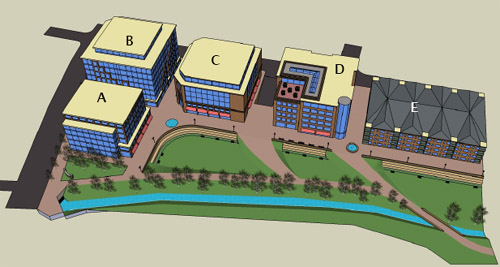
Rendering of a possible East Falls Church waterfront at Four Mile Run
In truth, it will take years for the City of agree to a plan, convince the landowners, find a developer, get financing, and construct the project. This is an idea, not an action proposal. But it’s a really good idea that seems to have legs. It meshes well with other likely redevelopment around the East Falls Church Metro, and could in the long term be a real winner.
It’s definitely something to keep an eye on.
Cross-posted at Greater Greater Washington.
Average Rating: 4.4 out of 5 based on 167 user reviews.
June 11th, 2010 | Permalink
Tags: master planning, proposal
|
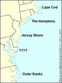
Beaches of the Northeast and Mid-Atlantic. |
From the founding fathers’ decision to name their federal city after George Washington, to WMATA’s neighborhood-defining station names such as Gallery Place and Virginia Square, to developer schemes like Penn Quarter, Washingtonians have never been shy about inventing names for places they deem important. BeyondDC certainly has not been shy, with proposals for Orangeington and Steeple Square.
In that vein, I think it is long past time that Washington’s summer playground get a name. If New England has Cape Cod, New York has The Hamptons, and Carolina has the Outer Banks, why shouldn’t our local collection of beaches have a single identifying moniker? In today’s installment at the Washington Post Local Blogging Network, I ask that question, and suggest that we adopt “Delmarva Shore” as a single name to describe the string of beaches from Cape Henlopen south to Toms Cove, including Ocean City.
Average Rating: 4.6 out of 5 based on 272 user reviews.
June 2nd, 2010 | Permalink
Tags: proposal, washpostblog
Every so often the question of Washington’s height limit comes up. Someone suggests we raise it, and a debate ensues. I’m on record opposing raising the height limit in downtown Washington, but supporting much taller buildings in secondary nodes like Rosslyn.
I have opposed raising the limit downtown because:
- I don’t think concentrating any more office space downtown is necessarily in the region’s best interests. I’d rather we have a bunch of mixed-use neighborhoods than an office ghetto surrounded by bedroom communities.
- There’s so much available land near downtown in places like Southwest and NoMa that we have ample room to expand the central office district without needing to raise the height limit.
- I fear that eliminating the height limit downtown would result in a push to tear down and redevelop too many historic buildings that are culturally valuable.
However, there is one good reason why raising the height limit downtown could be beneficial: It could make downtown a better neighborhood.
Downtown Washington may be the most intensely built part of the region, but it is almost completely commercial. There are so few residential units that vast swaths of downtown are almost completely devoid of people outside the hours of 9-5. If I want Washington to be a city of mixed-use neighborhoods, then downtown is failing. Even the downtown BID thinks this is a problem.
Getting more residents downtown is hard, however. For one, the parts of downtown that are most in need of it are already built out with office buildings. For two, commercial square footage generally rents at a higher rate than residential square footage, so any developer that can build office is more likely to do so than residential. Even if we change the zoning to require new buildings be residential, developers won’t be likely to tear down older office buildings in order to replace them with lower-renting residential ones.
The only answer is probably to up the density for residential projects, but not commercial ones.
But by how much? We need there to be some redevelopment of existing buildings, just not too much.
We could simply allow residential skyscrapers at unlimited height, but that would defeat the aesthetic reasons for having any height limit at all, and it might lead to the sort of land rush from point number 3, above.
What about a smaller rise?
The height limit is currently defined as the width of the street plus 20 feet. It would be possible to rewrite the regulation to provide a height bonus in exchange for incorporating residential square footage, say 20 additional feet of height in exchange for three floors of residential.
For example, let’s say you own a piece of land on a 90 foot wide street. You would currently have the right to build a 110 foot tall building with 10 floors of office space. With my suggested bonus option, you’d instead have the right to build a 130 foot tall building with nine floors of office and three floors of residential.
That would be enough of a windfall for most developers of new buildings to take advantage, but it wouldn’t be so much that redeveloping existing buildlings would be worth the cost to do so, unless you were going to redevelop anyway. We wouldn’t see wholesale demolition of historic properties, but we would see a substantial residential component anywhere a new building went up for other reasons, which happens often enough (as the empty lot at the corner of K Street and Connecticut illustrates).
I still don’t think there is any reason to allow skyscrapers downtown, or to raise the limit for more offices, but a modest height bonus for residential development along these lines would add people to downtown’s streets without significantly altering the city’s midrise character. It would incrementally improve downtown as a neighborhood, while allowing it to retain its role as regional commercial center.
I think the idea is a winner.
Cross-posted at Greater Greater Washington.
Average Rating: 4.7 out of 5 based on 257 user reviews.
April 28th, 2010 | Permalink
Tags: proposal, urbandesign
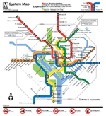
In 2007 graphic design firm KICK famously proposed redrawing the New York subway map. The new map they produced was more straightforward and intuitive than the official subway map, but also more diagrammatic. MTA eventually dismissed the proposal, but not before considerable internet buzz. Graphic designers and transit nerds still talk about it to this day.
And now graphic designer Cameron Booth has done the same for Washington. WMATA’s existing map is one of the world’s more iconic, but it has its faults, and as Booth notes, once the Silver Line is up and running there simply won’t be room on the page to continue the current scheme. His proposal is worth discussing.
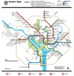
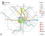
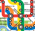
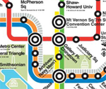
Three versions of the DC Metro map
Click each to enlarge.
| |
Existing WMATA map |
Future WMATA map
with narrower lines |
Booth map |
Full map |
 |
 |
 |
| Downtown |
 |
 |
 |
The Booth map has some real advantages. Instead of relying on clumsy call-out boxes for special notes, it graphically integrates all levels of peak and non-peak service. It shows MARC routes. Labels are more well-placed. It looks more up-to-date and professional.
On the other hand, Booth’s map has some real disadvantages too. First and foremost, it suffers from that most cardinal sin of transit maps: it’s too spaced out on the periphery and too crowded downtown. The whole point of using diagrams for transit maps instead of real geography is to avoid this problem, and Booth’s map is inferior to both WMATA entries in this regard. Lesser disadvantages are that the Beltway is too prominent, and that the smaller text and lines are harder to read at small scale.
Booth claims his map is more geographically accurate with regard to jurisdiction boundaries, but at best accuracy is a wash, as the lines themselves are more distorted. Shady Grove looks awfully close to the Beltway, there’s no curve at Tysons Corner, and Ballston is way too far west.
Overall, I think the Booth map is a great exercise, and offers some lessons that Metro definitely ought to adopt with its next redesign. I don’t, however, think the map is better overall, and would not suggest wholesale replacement.
What do you think?
Cross-posted at Greater Greater Washington.
Average Rating: 4.9 out of 5 based on 256 user reviews.
February 18th, 2010 | Permalink
Tags: metrorail, proposal, transportation
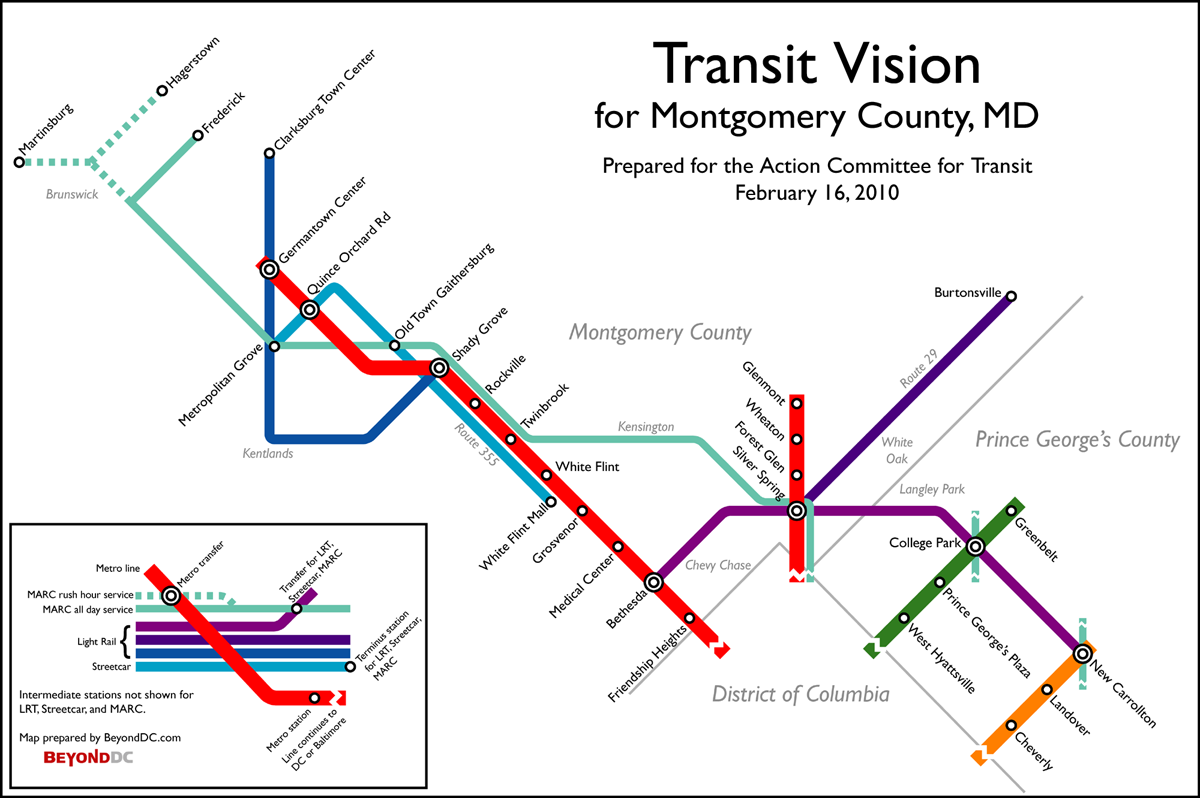
Last July, Montgomery County’s Action Committee for Transit worked with Greater Greater Washington to produce a transit vision for the I-270 corridor. Rather than spending billions of dollars on widening I-270 as the State of Maryland proposes, ACT and GGW argued that it would be better and more affordable to invest in a vigorous integrated transit network.
That was all well and good. BeyondDC agrees. But why stop with the I-270 corridor? There’s more to Montgomery County than Gaithersburg.
That in mind, ACT asked me to produce for them the following map, which expands their original 270 vision to encompass the entirety of Montgomery County.

ACT vision for Montgomery County. Click the map to enlarge.
The proposal includes:
- Extension of the Metrorail Red Line from Shady Grove north along I-370 and I-270 to MD Route 118, where it would end at Germantown Town Center. There would be one intermediate station at Quince Orchard Road, where the line crosses the CSX rail tracks.
- MARC improvements resulting in more frequent, all-day, bi-directional service to Frederick.
- A new spur of the MARC Martinsburg branch to reach Hagerstown.
- The completed Corridor Cities Transitway as light rail, with slight modifications to the route at Crown Farm and Kentlands, and a one-station extension to Clarksburg Town Center.
- The completed Purple Line, using the adopted Locally Preferred Alternative alignment.
- A new light rail line beginning at Silver Spring Metro and extending north along US-29 to Burtonsville.
- A new streetcar line beginning at White Flint Mall and running north along MD Route 355 through Rockville and Gaithersburg, ending at an expanded multi-modal Metropolitan Grove station.
- (Not shown on the map) Various bus priority and/or BRT improvements throughout the county, such as on Veirs Mill Road.
For more about their vision for Montgomery County, visit ACTfortransit.org.
Cross-posted at Greater Greater Washington.
Average Rating: 4.9 out of 5 based on 153 user reviews.
February 16th, 2010 | Permalink
Tags: commuterrail, lightrail, metrorail, proposal, roads/cars, streetcar, transportation
Norfolk’s 7.4 mile light rail starter line, The Tide, is currently under construction and due to open in 2011, and already Virginia Beach is looking to extend it. At the same time the Commonwealth of Virginia is studying increased passenger rail from Richmond to Hampton Roads, and just today President Obama awarded federal funds for high speed rail improvements south from DC.
With increased passenger rail such a hot topic in Tidewater Virginia, it seems a good time to consider what the future of rail transit there might look like. Assuming light rail is a success, as it is virtually everywhere it’s built, where might it go next? That Virginia Beach extension is the obvious next direction, but it’s far from the only option.
BeyondDC has extremely limited personal experience in Hampton Roads, but with satellite imagery from Google Maps available to anyone with a computer, it’s easy enough to get a pretty good sense of land use and density. Using that information it’s possible to make reasonably accurate assumptions about where transit might work best. Of course Google Maps is no substitute for real on-the-ground experience, but at the very least it’s enough to start a discussion. So here goes.
What a larger light rail system in Hampton Roads might look like:

Diagrammatic map.
Click to enlarge.

Geographic map, for context.
The red line is light rail currently under construction.
The orange lines are potential extensions.
Click to see it in Google Maps.
In total there are about 48.5 miles of light rail on these maps; 7.4 miles of under-construction-starter-line, plus a little over 41 miles of new proposal. The existing starter line is costing $288 million, or $39 million per mile. At that same per mile cost it would be another $1.6 billion to complete the entire system. That’s comparable to the cost of the DC streetcar system, for a much larger population. Obviously it is much less than the $5.1 billion Metrorail Silver Line.
Obviously there’s some weird stuff going on here. Those trips from downtown Portsmouth or Virginia Beach’s oceanfront to downtown Norfolk would take such a long time that I can’t imagine very many people would be interested in making them via rail. Nonetheless, those lines could be good corridors if you think of them as primarily serving downtown Portsmouth and the oceanfront, with the connections to the larger system merely a bonus. Hampton Roads is such a polycentric region that the normal of rail may not apply.
One last thing. There are probably critics who suggest that the Hampton Roads region is too small for such an ambitious system. That claim would ignore the experience of other mid-sized American metropoli, most particularly Salt Lake City, which is smaller and more suburban than Hampton Roads by just about every metric, yet has a successful system of 20 miles of light rail and 44 miles of commuter rail already in operation, with significant expansions to both planned.
So, what do folks think?
Average Rating: 4.9 out of 5 based on 152 user reviews.
January 28th, 2010 | Permalink
Tags: lightrail, proposal, transportation
|

Why aren’t DC cabs this iconic?
Photo by flickr user Ian Muttoo. |
One of New York’s most iconic images is the yellow taxicab. The image you see at right is as instantly recognizable as the Statue of Liberty or Empire State Building. In London the black cab is just as iconic. In Berlin they are all white, in downtown Hong Kong they are red, and in Mexico City they are green and white. In all those cases, the taxicab livery is as much a symbol of the city as any building or institution.
But not in Washington. In Washington every taxi company has a unique paint scheme. We have Red Top and Blue Top and Yellow Cab (which is often orange) and a hundred other varieties. Are we missing an opportunity?
In most American cities there aren’t enough taxicabs for this to even be an issue. If you’ve got to call ahead to get a ride, taxis are not going to be part of your city’s brand recognition no matter what. But Washington, it turns out, has a ton of cabs. By some measures we have even more than New York (go to the 8th page of this report). When I step outside my Dupont-area home there are often more taxis on the street than private vehicles. Clearly DC *could* have an iconic taxi design if the city so choose.
Why don’t we? It seems like a great way to improve the city’s brand, while at the same time making taxis easier to identify and therefore hail. If any livery-defining regulation grandfathered existing cabs and simply resolved that new ones be uniform, operators wouldn’t have to sink money into repainting, and would likely save money on the painting of new vehicles thanks to economics of scale. Eventually turnover would result in a uniform fleet. Everybody wins.
What’s the down side? Why aren’t we doing this?
Average Rating: 4.7 out of 5 based on 190 user reviews.
December 14th, 2009 | Permalink
Tags: proposal, transportation
Greater Greater Washington has recently been hosting a debate about the need for a more direct rail connection to Dulles Airport. Spencer Lepler has argued that Virginia should convert the W&OD trail to an interurban rail line providing express non-stop service to downtown Washington. In rebuttal, Matt Johnson has argued that the Silver Line is enough of an investment in the Dulles corridor, and that converting the W&OD trail would be impractical.
What if they’re both right?
There is a solution out there that would provide faster service to Dulles without requiring much new infrastructure: A skip-stop express. It would be possible for Metro to run express trains along the (soon to be) existing Silver Line route by simply not stopping at every station, as potentially illustrated here:

A potential skip-stop express to Dulles Airport. East of Rosslyn all trains would serve all stops, but west of Rosslyn the express would only stop at the highest-ridership stations.
True, there will be no express tracks on the Silver Line, but while that makes a skip-stop service more operationally difficult, it doesn’t necessarily preclude the option entirely. If cross-over tracks are provided at every station, local trains can pull onto the opposite track at any station in order to let express trains pass by. Doing so requires careful coordination and alert train operators, but it’s completely possible. The downside is that trains going in the non-peak direction may have to stop and wait between stations if a local has crossed over onto the opposite track, but it could be that the added peak-direction efficiency is worth the trade-off.
If such operational difficulties can be overcome, a skip-stop express would be a true win-win for both Spencer and Matt. It would provide a quick connection to the airport and a faster ride downtown for outer suburbanites (freeing up seats on local trains for closer-in passengers in the process), but wouldn’t require the kind of massive new investment that a whole second rail line would need. In fact, such a train would in all likelihood be even faster than a W&OD route, since it wouldn’t have to travel all the way south to Alexandria before crossing the Potomac.
If Metro can do this the region would get all the benefits of an express line without any of the headaches associated with the W&OD route. It would be a cheaper, faster, better alternative. There would be little downside.
Cross-posted to Greater Greater Washington.
Average Rating: 4.6 out of 5 based on 288 user reviews.
October 13th, 2009 | Permalink
Tags: featured post, proposal, transportation
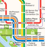
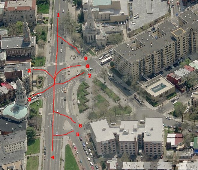
The intersection of 16th Street, Columbia Road, Harvard Street and Mount Pleasant Street is one of the most important in Mid-City. It’s where Adams Morgan, Mount Pleasant, and Columbia Heights come together at a single point. The steeples of its three famous churches make it one of the most prominent points in Mid-City’s skyline. Along with the next intersection to the north where 15th and Irving meet 16th, it’s a major stop for Metrobus S routes and the 14th Street Circulator.
But what do people call it?
Since it’s such an important part of the city’s geography, residents naturally refer to the intersection from time to time. However, unlike other important intersections such as Dupont Circle, there doesn’t seem to be any easy name for the place; no easy way to indentify it that everyone understands. Or at least, BeyondDC isn’t aware of one.
So, two questions:
- Does anyone know of a name for this intersection? Maybe there’s an obscure one floating out there that I’ve never heard. Does the little park next to it have a name?
- If there isn’t a name right now, what might be a good one? Steeple Square? Nine Points? Mount AdMo Heights?
What do you think?
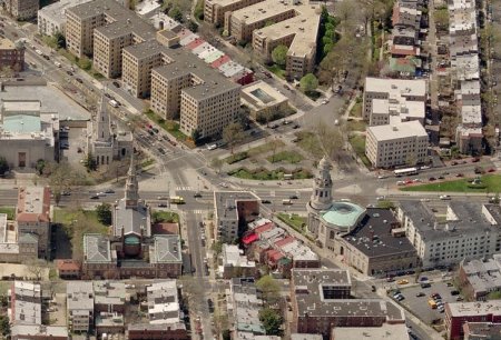
16th and Columbia, better known as ???
Average Rating: 4.4 out of 5 based on 173 user reviews.
August 3rd, 2009 | Permalink
Tags: proposal
|
Media


Site
About BeyondDC
Archive 2003-06
Contact
Category Tags:
Partners
|


