|
Special Features


Image Libraries


|
|
Blog
As marijuana legalization took effect in the District of Columbia, Mayor Muriel Bowser said DC would “not become like Amsterdam.” We talked about the differences yesterday, including on bicycling and transit, but the Embassy of the Netherlands has playfully responded with this infographic comparing our two capital cities.
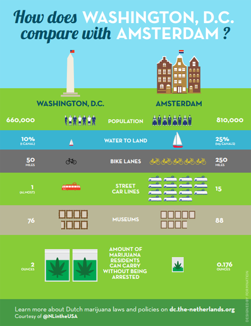
Image from the Dutch government. Really.
The embassy also created a Q&A comparing marijuana laws in the two cities. But bicycling and transit supporters might focus more on the bike lane and streetcar disparities.
That “(almost)” hurts. Low blow, Netherlands.
 Cross-posted at Greater Greater Washington. Cross-posted at Greater Greater Washington.
Average Rating: 4.7 out of 5 based on 291 user reviews.
February 27th, 2015 | Permalink
Tags: bike, fun, streetcar, transportation

According to yesterday’s Express, DC is starting to look a lot like Amsterdam, and not just because of marijuana. That’s fantastic if true.
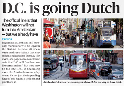
The top of yesterday’s Express story.
Among the reasons the Express cites for DC’s Amsterdamization are increasing bicycle use, the appearance of streetcars, and Georgetown’s improving C&O Canal.
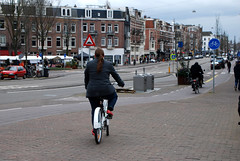
Amsterdam is one of the world’s great bicycling and streetcar cities. It’s a joy to travel along its extensive bikeways, and even lanes where cars are allowed are amazingly bike friendly. And Amsterdam’s huge streetcar network (with streetcars in both dedicated lanes and mixed traffic) is a case study in successful urban transit.
DC’s nascent bikeway and streetcar networks pale in comparison, but Amsterdam is a superb model for us to aspire towards.
And if it’s true that we can never hope to have as many canals (short of a disastrous global warming-induced flood), we can at least ponder what might have been had the history of Constitution Avenue turned out differently.
Even more similarities
Transportation and canals aside, Amsterdam’s overall urban design is actually incredibly similar to DC’s. We’re both predominantly rowhouse cities, with plenty of brick. Even our street grids are similar: Amsterdam has a relatively small core with twisty medieval streets, but for the most part it’s a city of straight streets and radial avenues just like DC.
These scenes from Amsterdam wouldn’t look all that out of place in Dupont Circle, U Street, or Adams Morgan, apart from how little street space goes to cars..
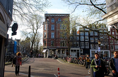 
Amsterdam, but could be DC.
Admittedly, Amsterdam beats DC in a lot of ways. But it’s not Paris or Hong Kong, not so thoroughly alien. And DC is not Las Vegas. Amsterdam and DC aren’t identical, but we’re the same species of city, which means Amsterdam is better in ways that DC can practically emulate.
Plus, we’ve got Amsterdam Falafelshop.
Cross-posted at Greater Greater Washington.
Average Rating: 4.9 out of 5 based on 221 user reviews.
February 26th, 2015 | Permalink
Tags: architecture, bike, streetcar, transportation, urbandesign
DDOT has released a list of new bikeways it will add in 2015. Although most of the additions this year will be short, they’re important. This year’s work will specifically focus on closing gaps in the network, in order to make existing bike lanes more useful.
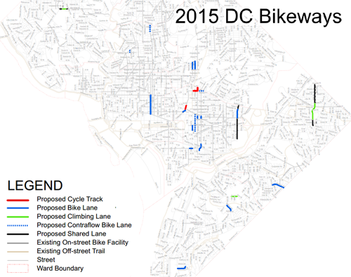
Planned bike lanes in 2015. Image from DDOT.
In total there are about seven miles of new bikeways on the list, including three short protected bikeways, about four miles of striped bike lanes, and two miles of sharrows.
According to DDOT’s Darren Buck, “We’re hoping to address several short but valuable network connection links that are easy to overlook on a map, but people have been requesting for years.”
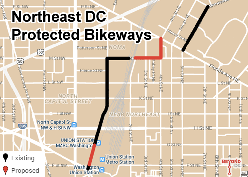
The new protected bikeways are all in Northeast, on M Street, 4th Street, and 1st Street. Collectively they’ll begin to stitch together Northeast’s existing patchwork of disconnected cycletracks into a more useful and cohesive network. An unprotected contraflow lane continuing along M Street will help that effort too.
Basemap from Google.
Besides the Northeast protected bikeways, other notable additions include a normal bike lane on 12th Street NW downtown, along with several east of the Anacostia and in Capitol Hill, and short but important connections on 11th Street NW, Ontario Road NW, 2nd and 3rd Streets NE, and crossing I-695.
This project list is separate from the list of ten car lane to bike lane conversions that came out in January. The bike lanes in January’s list are still in planning, and will likely happen in future years.
Here’s the complete street by street list of DDOT bike lane additions for 2015.
Cross-posted at Greater Greater Washington.
Average Rating: 4.8 out of 5 based on 249 user reviews.
February 20th, 2015 | Permalink
Tags: bike, transportation
As US bikesharing continues to boom, it’s fun to look back each year and see how systems have grown. Now that we’re into the grind of 2015, let’s look back on 2014 and see what changed.
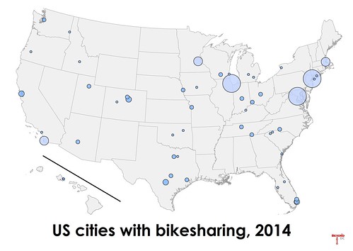
2014 was a modest year for US bikesharing expansion, compared to the incredible boom of 2013. Overall, the number of bikeshare stations nationwide increased about 20%, from 1, 925 in 2013 to 2, 345 in 2014. San Diego launched the largest new system, with 117 stations.
Washington’s Capital Bikeshare regained its crown as largest overall network, growing from 305 stations to 347 stations. Last year’s champ, New York’s Citibike, actually lost two stations and dropped from 330 to 328. Chicago rounds out the top tier, with the same number of stations it had last year: 300 exactly. No other system tops 200 stations.
14 new bikesharing systems opened nationwide, and four small existing ones closed, bringing the US total up to 50 active systems.
The west coast began to catch up to the rest of the country. In addition to San Diego, Seattle opened the next largest new system of 2014, with 49 stations.
Here’s the complete list of all US systems. New ones are marked in bold. Previous years are available for comparison.
| Rank |
City |
2013 Stations |
2014 Stations |
| 1 |
Washington (regional) |
305 |
347 |
| 2 |
New York |
330 |
328 |
| 3 |
Chicago |
300 |
300 |
| 4 |
Minneapolis (regional) |
170 |
169 |
| 5 |
Boston (regional) |
132 |
140 |
| 6 |
San Diego |
0 |
117 |
| 7 |
Miami Beach |
97 |
94 |
| 8 |
Denver |
81 |
83 |
| 9 |
San Francisco (regional) |
67 |
70 |
| 10 |
San Antonio |
51 |
53 |
| 11 |
Seattle |
0 |
49 |
| 12 |
Austin |
11 |
45 |
| 13 |
Boulder |
22 |
38 |
| 14(t) |
Fort Worth |
34 |
34 |
| 14(t) |
Miami |
0 |
34 |
| 16 |
Chattanooga |
33 |
33 |
| 17 |
Columbus |
30 |
30 |
| 18(t) |
Madison |
32 |
29 |
| 18(t) |
Cincinnati |
0 |
29 |
| 20 |
Houston |
29 |
28 |
| 21 |
Indianapolis |
0 |
26 |
| 22 |
Omaha |
8 |
25 |
| 23(t) |
Nashville |
22 |
24 |
| 23(t) |
Charlotte |
21 |
24 |
| 23(t) |
Phoenix |
0 |
~24 |
| 26 |
Ft Lauderdale (regional) |
25 |
21 |
| 27(t) |
Kansas City |
12 |
20 |
| 27(t) |
Salt Lake City |
12 |
20 |
| 29 |
Aspen |
12 |
15 |
| 30 |
Long Beach, NY |
13 |
14 |
| 31 |
Washington State Univ (Pullman, WA) |
9 |
11 |
| 32 |
Milwaukee |
0 |
10 |
| 33 |
Greenville, SC |
6 |
8 |
| 34(t) |
Oklahoma City |
7 |
7 |
| 34(t) |
Tampa |
0 |
~7 |
| 36(t) |
Des Moines |
6 |
6 |
| 36(t) |
Ann Arbor |
0 |
6 |
| 38 |
Univ of Buffalo (Buffalo, NY) |
4 |
5 |
| 39(t) |
California Univ – Irvine (Irvine, CA) |
4 |
4 |
| 39(t) |
Spartanburg, SC |
4 |
4 |
| 41(t) |
Tulsa |
4 |
3 |
| 41(t) |
Louisville |
3 |
3 |
| 41(t) |
Stony Brook Univ (Stony Brook, NY) |
3 |
3 |
| 44(t) |
Kailua, HI |
2 |
2 |
| 44(t) |
Roseburg VA Hospital (Roseburg, OR) |
2 |
2 |
| 44(t) |
Hailey, ID |
2 |
~2 |
| 44(t) |
Rapid City |
0 |
2 |
| 44(t) |
Savannah |
0 |
2 |
| 44(t) |
Dallas |
0 |
2 |
| 44(t) |
Orlando |
0 |
~2 |
|
Fullerton, CA (closed) |
10 |
0 |
|
Georgia Tech (Atlanta, Ga) (closed) |
9 |
0 |
|
George Mason Univ (Fairfax, VA) (closed) |
7 |
0 |
|
Lansing (closed) |
4 |
0 |
Systems marked with a ~ are stationless bikeshare networks, in which each bike contains a lock and can be docked anywhere. The number of “stations” reported for three of these four systems (Phoenix, Tampa, and Orlando) is approximate and is was calculated by dividing the overall number of bicycles by 8. The fourth system, Hailey, has only six bikes but they’re located in two distinct clusters, so it seems most appropriate to report two stations.
Counting the number of bikes rather than stations would be a more accurate way to rank systems, but that information is more difficult and time-consuming to obtain.
Cross-posted at Greater Greater Washington.
Average Rating: 4.5 out of 5 based on 150 user reviews.
February 12th, 2015 | Permalink
Tags: bike, transportation
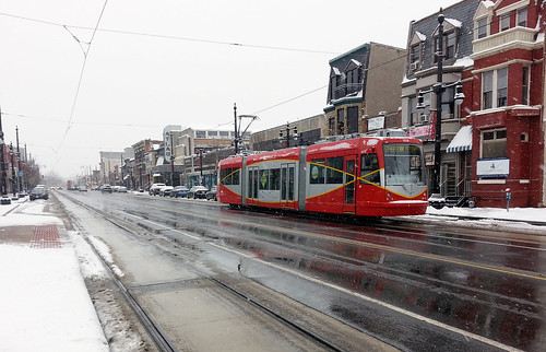
Now that DC’s oft-delayed H Street streetcar is hopefully near opening, DDOT officials are planning the next wave of lines. One of the biggest emerging questions (besides the role of dedicated lanes) is where the streetcars should run without wires.
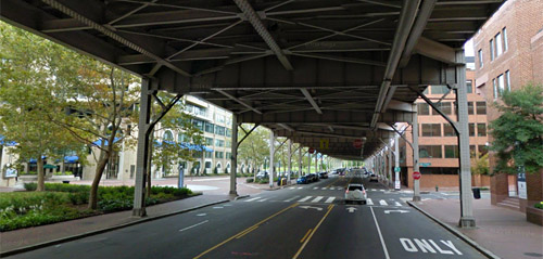
Current law prohibits wires under the Whitehurst Freeway. Should that change? Image from Google.
DC has important monumental views that wires could impact. Therefore, DDOT has been promising hybrid streetcars that can run off-wire for part of their route since 2009. It could mean wires along some roads but not at major intersections, crossing state avenues, or across the National Mall, for example.
DC Councilmember Mary Cheh is convening a public hearing today to discuss the question with District Department of Transportation (DDOT) officials including new director Leif Dormsjo.
Where wires are legal
Current DC law prohibits overhead wires in the central L’Enfant city (basically everything between Florida Avenue and the Anacostia River) and Georgetown, except on H Street. In 2010, the council exempted H Street from the law, specifically to permit streetcars there.
But only exempting H Street was never a permanent solution. It was a stopgap to let H Street move forward while giving DDOT time to study wire-free planning in more detail. Now it’s time for a broader plan.
Wires on H Street.
Is wireless technology ready?
The 2010 law also required DDOT to study wireless streetcar technology before building any other lines, so leaders could make an informed decision about other exemptions.
DDOT completed that study in mid-2014, and in it concluded that off-wire technology is still only practical for short distances. Batteries, ground-based power supplies, and various other wire-free systems do exist, but they’re vastly more expensive and vastly less reliable than traditional overhead wires. Hybrid streetcars that operate on-wire part of the time, and off-wire at other times, remain by far the best option.
Moving forward, the DC Council could opt to change the wire law in one of four ways: 1) Keep the existing law allowing wires only outside the core; 2) Prohibit wires everywhere; 3) Allow wires everywhere; or 4) Allow wires in certain additional locations, but not others.
DDOT’s report proposes an approach in line with option 4:
In the near term, proven overhead contact system (OCS)-based technologies will form the basis of the system, with limited application of off-wire technologies in the most sensitive areas to the extent possible. As technologies advance, the amount of off-wire operations will be gradually increased.
This option makes sense. Most people agree that the north-south streetcar line should be wireless when it crosses the National Mall, but it would be absurd to demand the K Street line be wire-free when it runs under the Whitehurst Freeway.
Others worry that DDOT will not actually “gradually increase the amount of off-wire operations” once wires are in the ground. If DC buys streetcars that can handle only limited off-wire operation, it would cost money to upgrade, and that might not happen for a long time.
But wire-free technology still only works for short distances, so a hybrid is still the way to go. Modern streetcar wires can be relatively unobtrusive and won’t mar the streetscape. Allowing overhead wires in some other areas while prohibiting them in the most sensitive spots is the rational solution.
Cross-posted at Greater Greater Washington.
Average Rating: 4.4 out of 5 based on 213 user reviews.
February 4th, 2015 | Permalink
Tags: events, preservation, streetcar, transportation
|
Media


Site
About BeyondDC
Archive 2003-06
Contact
Category Tags:
Partners
|


