One common criticism of bicycling is that it’s all well and good for dense core cities, but isn’t a serious transportation option in suburban areas. Suburbs in other countries prove that’s wrong.
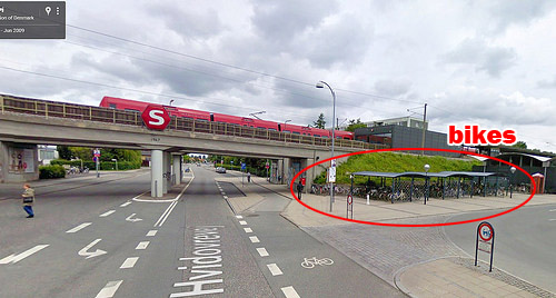
Bike parking at Friheden Street transit stop in suburban Copenhagen. Photo from Google.
The photo above is from Friheden Street station, in suburban Copenhagen. And look at all those beautiful bike racks. How did they get there?
One of the most important uses for bicycles is as a last mile tool, to get from one’s home to a transit station, or from a transit station to one’s final destination.
Anywhere you have a transit station with a lot of other buildings a mile or two away, bikes can help connect one to the other. That includes suburbs.
If you provide the necessary infrastructure, and treat bicycling like a serious option, people will use it.
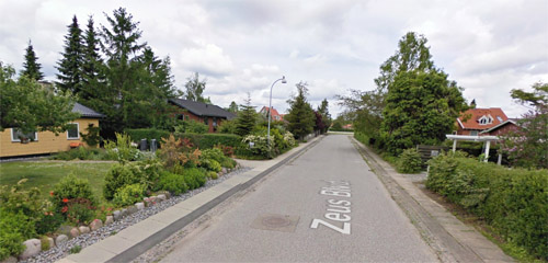
Yes, that’s a suburb
Unlike central Copenhagen, which is dense and difficult to drive a car through, the area around Friheden Street is suburban and relatively low density. Actually it looks a lot communities around the Washington Beltway.
Residential Friheden. Photo from Google.
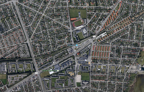
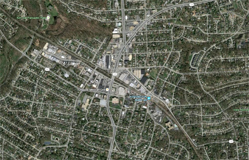
Compare these two aerial photos, taken at about the same scale. The first image shows the area around Friheden Street station. The second shows Kensington, in suburban Washington.
Suburban Copenhagen. Photo from Google.
Suburban Washington. Photo from Google.
They look pretty analogous. Not exactly the same, to be sure; Friheden has a few apartment buildings sprinkled in, and its S-train station offers better service than Kensington’s MARC station. But they’re not so dissimilar as to be completely alien. They’re siblings, if not quite twins.
I admit I’ve never been to Friheden Street. I’ve never even been to Denmark. Frankly I have no idea if it’s a pleasant community, or what the less desirable things about it may be. I’m sure there are trade-offs to it, compared to an American suburb.
But I happened to be on Google Earth looking at Copenhagen, which is famously a bike paradise, and wondered what its suburbs look like. I turned on Google’s transit layer and started looking at the areas around suburban stations. Friheden Street just happens to be one I zoomed in on.
A sporty coupe glides joyfully along a seaside highway, all by itself. It’s heaven for the anonymous driver. That’s the standard, ridiculous car commercial.
This video shows what car commercials would look like if they were actually honest.
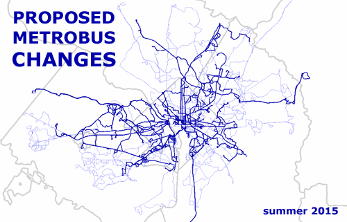
Metrobus planners are proposing to change bus service on almost 100 routes, all over the Washington region. If the changes happen, many routes will see better service, others will face cuts, and some will go away completely, including the popular 5A bus to Dulles Airport.
Every WMATA bus route. Thick blue lines are route families that will change. Thin blue lines are families that will not. Sketch map from the author.
WMATA’s proposal generally aims to increase service on routes with a lot of riders, and decrease it on ones with fewer riders. According to WMATA, the changes will “improve overall on-time performance and customer satisfaction, increase ridership, and improve cost recovery.”
To get feedback on the idea, Metro has an online survey and will run a series of public meetings. If the WMATA board approves the changes this October, they’ll take effect in stages beginning in December 2015 and rolling out through mid 2016.
Greater Greater Washington hopes to analyze these changes and report back in a future post. For now here’s a list of every proposed change. For more details, including route maps and more detailed descriptions of changes, see Metro’s page for the project.
Changes to routes in DC:
5A: Eliminate all service.
34: Eliminate route 34 on evenings and weekends.
54: Shorten route by eliminating segment between McPherson Square and L’Enfant Plaza. Improve frequency between 14th & Colorado and Takoma Station.
63: Add one AM peak trip.
64: Add one AM peak trip and one PM peak trip, and increase scheduled running time.
79: Add four AM peak trips and four PM peak trips.
80: Shorten route by eliminating service between McPherson Square and Kennedy Center. See D4 below for replacement service.
81, 83: Eliminate route 81 and convert its trips to route 83 (contingent upon adding Sunday service on the revised C2 line).
82: Eliminate two AM and three PM trips.
90, 92, 93, 94: Eliminate route 93. Add trips on routes 90, 92 and 94 to compensate.
97: Add one AM peak trip
A2, A6, A8, A42, A46, A48, P6: Eliminate routes A42, A46, A48. Replace with additional trips on routes A2, A6, A8, and P6.
B8, B9: Eliminate routes.
D1: Shorten route by eliminating segment between Franklin Square and Federal Triangle. Reduce service hours.
D3: Eliminate entire D3 route.
D4: Extend route D4 from Franklin Square to the Kennedy Center to replace cut segment of route 80.
E2: Increase scheduled running time.
E4: Increase scheduled running time.
G8: Shorten some AM peak trips to start at Brookland Station. Add three AM peak trips. Add some PM peak trips between Brookland Station and Avondale. Increase scheduled running time.
H6: Reroute in Fort Lincoln via Costco.
N3: Eliminate entire N3 route.
S9: Add two AM peak trips and one PM peak trip.
U8, W4: Extend some peak U8 trips to Congress Heights. Reduce peak trips on the W4 route. Improve combined U8/W4 frequency between East Capitol & Benning and Congress Heights from 10 minutes to 7.5 minutes. Increase scheduled running time for the W4.
X1, X3: Shorten X3 route to end at Duke Ellington Bridge. Increase scheduled running time.
X8: Add one AM and PM weekday round trip; add one PM Saturday and one PM Sunday round trip.
X9: Add two AM peak trips and two PM peak trips. Increase scheduled running time.
Changes to routes in Maryland:
81, 83: Eliminate route 81 and convert its trips to route 83 (contingent upon adding Sunday service on the revised C2 line).
B29, B31: Eliminate route B31. Convert existing B31 trips to B29 short trips between New Carrollton Station and Bowie Park and Ride.
C2, C4: Restructure service. Turn around half of C4 trips at Wheaton rather than running all trips to Twinbrook. Operate C2 at reduced frequency between Greenbelt station and Takoma Langley. Add additional C4 trips. Add Sunday service on route C2 between Greenbelt and Takoma Langley.
F4: Improve Saturday schedule reliability.
G12, G13, G14, G16: Eliminate routes G13 and G16, and convert their trips to G14. Shorten G14 to eliminate service on Aerospace Road. Add Sunday service to G12 and G14.
K11, K12: Eliminate route K11, and convert its trips to run as K12.
J12, J13: Eliminate route J13, and convert its trips to run as J12.
Q1, Q2, Q4: Discontinue route segment between Wheaton and Silver Spring stations during Metrorail operating hours. Add special rail fare discount between Wheaton, Forest Glen and Silver Spring Stations to reduce the number of bus trips needed on this segment.
Q9: Add new route: Limited‐stop Metro Extra on Veirs Mill Road between Rockville and Wheaton stations. Service would operate on weekdays only, every 15 minutes between 7:00 a.m. and 8:00 p.m.
R3: Eliminate entire line.
V14, V15: Eliminate route V15 and convert its trips to run as V14. Improve Sunday service by running the full V14 route and expanding service hours to match Saturday service.
W19: Transfer route operations to MTA Commuter bus. Eliminate service south of Bryans Road. Reduce service frequency to every 30 minutes. Reduce hours to being later in the morning and/or end earlier in the evening.
Z6, Z8: Add Z6 Saturday service between Silver Spring Station and Castle Blvd. Reduce Z8 Saturday frequency to coordinate with new Saturday Z6.
Z9, Z11, Z13, Z29: Restructure service to combine routes.
Changes to routes in Virginia:
1A, 1B, 1E, 1Z: Eliminate 1E and replace with ART service in Dominion Hills. Eliminate route 1Z and convert its trips to 1B. Restructure route 1B to bypass Seven Corners Shopping Center and eliminate 1B service on certain holidays.
1C: Improve schedule reliability.
2B: Add hourly Sunday service.
3T: Shorten route by eliminating service between West Falls Church Station and East Falls Church Station. Eliminate
supplemental trips on certain holidays.
4A, 4B: Eliminate all Saturday service on route 4A. Eliminate supplemental trips operated on route 4B on certain holidays.
5A: Eliminate all service.
7A: Eliminate all trips after 1 AM on Friday and Saturday nights
7H, 7X: Eliminate route 7H. Shorten route 7X by eliminating service between Lincolnia Road and Arbor Park.
7Y: Terminate alternating trips in the District, bypassing the Pentagon. Terminate remaining trips at the Pentagon without service into the District. For trips entering the District, re‐route using 14th Street Bridge to access the District, and eliminate service between 18th and I Streets NW and the Convention Center.
9A: Eliminate entire line. See 10A restructure to replace missing coverage.
9A, 10A, 10R, 10S: Eliminate 9A, 10R, and 10S completely. Convert some trips to 10A to compensate. Restructure 10A service to provide coverage to Powhatan Street and Huntington Station lost by eliminating the 9A line. Would eliminate service connecting Alexandria and Crystal City to Rosslyn.
10B: Improve weekday peak frequency from every 30 minutes to every 15 minutes, and Sunday frequency from every 60 minutes to every 30 minutes.
15K, 15L: Improve weekday schedule reliability.
15M: Eliminate entire line.
16H: Shorten 16H route by eliminating segment between Crystal City and Pentagon City.
16X: Extend 1 AM and 3 PM weekday peak‐period trips to Culmore.
18E, 18F, 21A, 21D: Eliminate entire 18E and 18F line. Restructure 21A and 21D to cover Bren Mar Park, and transfer route operation to Alexandria DASH.
23A, 23B, 23T: Split off‐peak and weekend service to match weekday peak‐period route pattern, to improve frequency between Shirlington and Ballston.
26A: Improve weekday peak frequency from every 60 minutes to every 30 minutes.
28X: Reduce frequency from 15 minutes to 30 minutes, OR reroute to terminate at East Falls Church, thereby not serving West Falls Church or Tysons.
29N: Improve weekend service frequency from every 60 minutes to every 30 minutes.
38B: Eliminate supplemental trips on certain holidays.
Maryland’s MARC train and Virginia’s VRE are very similar regional rail systems. This map shows what they might look like as a single integrated regional network.
Map from Peter Dovak at Transit Oriented.
Although MARC and VRE are so similar, they operate totally independently of each other. Riders on one may not even be aware the other exists. This map would help solve that.
The two agencies will probably never merge, but it might someday be possible to integrate their operations to work more like a single system. MARC trains might run across the Potomac into Virginia, and VRE trains might one day continue north into Maryland. It would be difficult but possible.
In the meantime, this map from Peter Dovak at Transit Oriented is a nice unofficial first step. And it’s easier on the eyes than the current official MARC or VRE maps.
Boston has backed out of its bid to host the 2024 Olympics, and officials are begging DC and other cities to try and host the games. But fewer and fewer cities want to. What if, instead of picking one host city, the entire country pitched in, with venues spread out in several cities coast to coast.
Don’t pick one. Pick them all. And add 10 more. Image by the USOC.
The Olympics have a big problem. Virtually no democratic cities anywhere in the world want to host them anymore. The combination of sky-high costs for new facilities, and the inconveniences put upon the populace by way of construction and tourist traffic, have made the Olympics too much for one city to bear.
But why should one city have to?
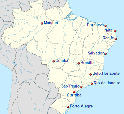
To save the Olympics, the FIFA World Cup offers a compelling alternate in which countries host instead of cities.
Brazilian host cities for the 2014 FIFA World Cup. Image from Wikipedia.
Different events would take place in different locations, hundreds or even thousands of miles apart. No single city would have to shoulder the burdens of more than one or two events.
With a whole country to choose from, organizers could find existing facilities for virtually every event. Much less new construction would be necessary. Many fewer one-time-use buildings would become abandoned after the games end.
And with fewer athletes and visitors in any one location, existing infrastructure and hotels could accommodate more of the influx of guests, with less disruption to residents. Hosting a single Olympic event would be more like hosting a college football bowl game, or the baseball All Star game.
In short, everything would become easier.
And although it’s true that some World Cups suffer from overspending too, certainly the problem is less acute when it’s spread over an entire nation.
The downside
This would admittedly be a drastic change to the culture of the games. It would be difficult for anyone to attend more than one event in person. Athletes would no longer live and socialize in a single Olympic Village. Something about the in-person experience of being in a city dedicated completely to the Olympics would be lost.
But that overwhelming experience is part of why so many cities don’t want to host the Olympics anymore. For residents whose lives are put on hold, it’s a bug, not a feature.
Meanwhile, the opening and closing ceremonies would still provide glimpses of that invigorating everyone’s-here feeling. It would be a trade-off, but perhaps a worthwhile one.
What role would DC play?
If Olympic officials spread the wealth/burden, what events might DC be fit to host?
A look at the possible venues for DC’s 2014 bid shows what facilities already exist, and therefore might be a good fit.
We probably wouldn’t get the opening ceremony. That needs an NFL-sized stadium, and our only options are either too old or too isolated. They’d work in a pinch, but some other US city can probably offer something more appealing.
Weightlifting could occur at Constitution Hall. The convention center could host table tennis, handball, or badminton.
The marathon could follow the path of the Marine Corps marathon. Rowers could set off from Georgetown.
And of course, the Verizon Center would be a killer spot for basketball. Or really any gym sport. How about gymnastics?
How would this change your opinion of the games? Would readers who oppose a DC Olympiad support a US games, with only one or two venues in DC?
Pershing Park is one of DC’s most unique and potentially pleasant public spaces. Unfortunately, few people have ever enjoyed it, because the park’s best elements are hidden from view behind an uninviting raised embankment.
Pershing Park as seen from Pennsylvania Avenue. Photo by Google.
It’s nice on the inside
I like Pershing Park, at Pennsylvania and 15th Street NW. I wish it worked better.
The inside of the park is a terraced wetland garden that, when it’s in good condition, is absolutely lovely.
The pleasant interior. Photo by pcouture on Flickr.
There are ample shady seats, a duck pond to dip your feet in, and climbable concrete terraces that make the park feel like an adult-size jungle gym.
It’s fun, and pretty, and unlike anything else in DC.
Or at least, it was fun and pretty a few years ago. The park has fallen into disrepair lately. The pond is dry. Orange cones litter the open plaza. It’s abandoned and depressing.
Part of Pershing Park’s problems are simply neglect. Better maintenance could fix the pond and the concrete.
But there’s one big problem, and it may well be unfixable.
People can’t see it
Most people don’t know the park is there. You can’t see it from the street. From three sides, the only thing visible is a grassy embankment straight out of a suburban McDonalds parking lot. The fourth side is literally a parking lot.
Pershing Park from above. Image from Google.
Good urban parks draw pedestrians in from the surrounding sidewalk. When you’re standing outside Dupont Circle, you can see and hear interesting things happening inside the park there. The activity and people inside Dupont make you want to enter it yourself.
Pershing Park is the absolute opposite. It’s plain and boring from the sidewalk. There are interesting things there, but you can’t see them so they don’t draw you in.
Most people just ignore it; the park blends into the background and they don’t give it a second thought.
Those who do look closely see a bunker, a hostile sloping hill with few entry points. From busy Pennsylvania Avenue, Pershing Park more closely resembles an 18th Century military stockade than an inviting civic space.
Until that problem is solved, Pershing will never be a good park, no matter how pleasant it is on the inside. Until that’s solved, Pershing will always be an afterthought.
Let’s fix it
What to do with Pershing Park is increasingly becoming a hot-button issue. One group wants to redevelop it as a national World War I memorial. Kriston Capps at CityLab takes a preservationist bent and says we should restore it.
Either way, the park is falling apart and needs work.
Would it be possible to save the pleasant interior and radically change the bunker exterior? Maybe, maybe not. The park occupies sloping terrain that any design will have to work around. Unfortunately, there’s no way to avoid a retaining wall somewhere. At least not if we want to keep the terraces.
But retaining walls don’t have to be so plain or uninviting. There are betterexamples elsewhere in the city.
It would be a shame to lose such a unique space. If designers can find a way to restore Pershing Park’s terraces and pond while altering the park’s exterior to be more inviting, that would be an ideal solution.
But if not, tear the sucker out. A downtown park that nobody uses isn’t a useful downtown park.


 Comment on this at the version cross-posted to Greater Greater Washington.


