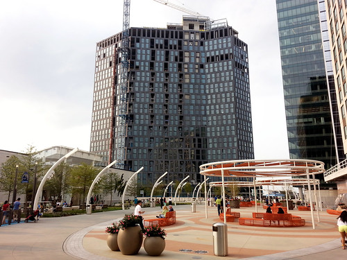
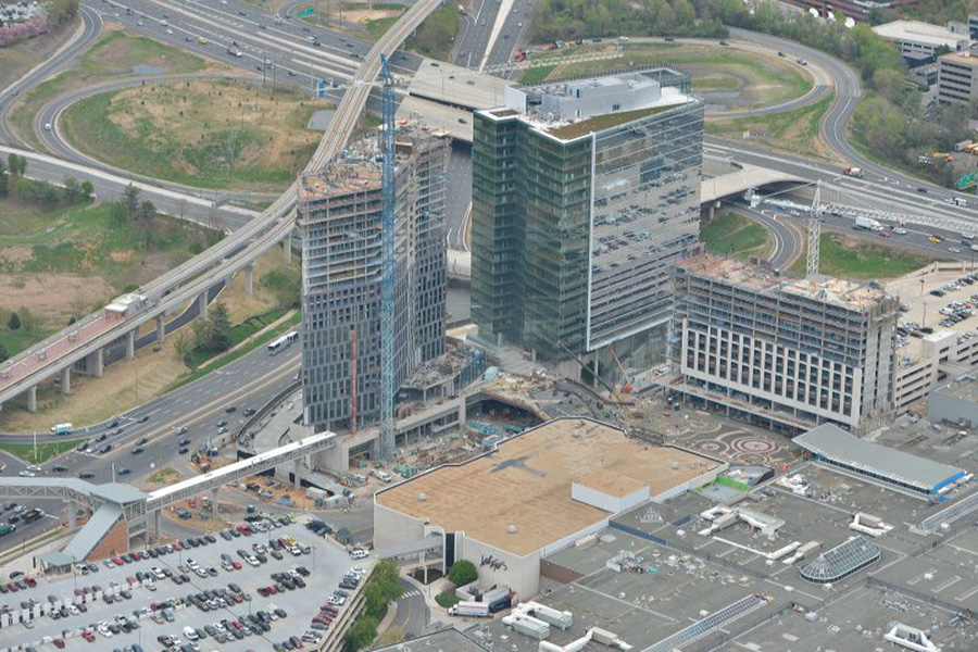
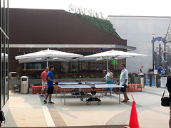
Metro’s Silver Line isn’t the only indication the transformation of Tysons Corner is clearly underway. Further undeniable evidence: The Plaza, a popular new urban-style open space at the front door to Tysons Corner Center mall.
The Plaza (that’s its official name) is on the north side of the mall, near the pedestrian bridge from the Tysons Corner Metro station. Three new high-rises are under construction around the plaza, tightly enclosing the space like a genuine city square.
The Plaza and its surroundings. Original photo from Macerich.
The pedestrian bridge to the Metro station isn’t open yet, because the high-rise it connects is still under construction. But when all is said and done, The Plaza will become the main entry point to the mall from the Metro. In a very real sense it will become the center of this emerging urban neighborhood.
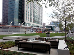
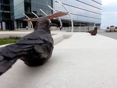
Befitting Tysons, The Plaza is a thoroughly contemporary update on the classic city square. There’s no marble statue in the middle, no grand fountain like in Dupont Circle. Instead, there are padded couches, small-scale artistic flourishes, and outdoor games.
One crucial difference between The Plaza and a traditional city square is who owns it. This may masquerade as civic space, but it’s clearly private property. Security guards patrol the square, and you can bet homeless people aren’t welcome to sleep on benches.
But still, The Plaza is a big step forward for Tysons. It’s a genuine gathering place, and people are using it. Even without the Metro connection, plenty of other people were hanging out nearby when I visited last weekend. It’s not the kind of place that a mere 20th Century office park would support.
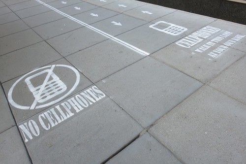
A curious thing appeared on a downtown DC sidewalk this week: Dedicated lanes for pedestrians talking on cellphones, with an express lane to the side for everyone else.
National Geographic workers added the sidewalk lanes, with permission from DDOT, to film people’s reactions for an upcoming TV show about human behavior.
Film crews recorded pedestrians’ reactions for several hours yesterday. The most common reaction seemed to be curiosity, but according to Yahoo! Tech columnist Rob Pegoraro, the new lanes did inspire many people to move to one side or the other.
The sidewalk lanes are marked on the 1000 block of 18th Street NW, between K Street and L Street.
This might have drawn inspiration from a “tourist lane” New York-based group Improv Everywhere painted on a Manhattan sidewalk in 2010.
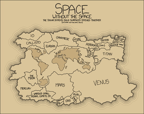
Someday, unless humanity descends into a dark age, we’ll colonize space. Here’s how much land we’ve got to work with, within our solar system.
Image from xkcd.
This chart (it’s not really a map) is to scale for area but obviously not shape. Except Earth’s continents, the shape of the borders are fully the creative license of the illustrator. This simply shows how large each solid planet & moon in our solar system would be, if they were all combined into a single huge continent.
Average Rating: 4.4 out of 5 based on 161 user reviews.
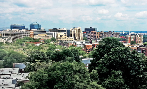
I Wish I’d had a better-quality camera last week when I got to enjoy this fantastic view of Rosslyn, the US Capitol, and the Washington Monument. Alas, a cell phone snap is as good as it gets.
Average Rating: 4.5 out of 5 based on 246 user reviews.
The European Space Agency recently began broadcasting a real time feed from its Earth-facing camera onboard the International Space Station. You can follow it here, or use the tracker for geographic orientation.
Real-time view from the International Space Station. Live streaming video from Ustream.
Average Rating: 5 out of 5 based on 263 user reviews.
What does it look like when one of Philadelphia’s most prominent skyscrapers becomes a giant Tetris game board?
It looks awesome, that’s what.
Photo by Bradley Maule for PhillySkyline.com.
Last Saturday, organizers for Philly Tech Week temporarily turned the 29-story Cira Centre into a huge game of Tetris. And it wasn’t just for looks. Actual people played actual games, with the whole city looking on.
Update: More tips & tricks are now listed at the bottom of this post! – 3.8.2014, 12:45 pm
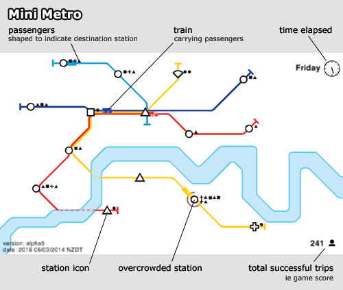
Mini Metro is a fun browser game that simulates a transit network.
Stations representing different types of destinations pop up, and you have to connect them with metro lines that take passengers where they want to go.
Screencap of the game, with components labeled.
The game starts off easy. You get one square station icon, one triangle, and one circle. Connect them with a single transit line and you’re all set.
But after a few moments more stations start to pop up. You have a limited number of metro lines to work with, and each line only gets one train. So the more stations appear, the longer it takes for a train to traverse the line, and the more passengers build up.
Ideally you want each transit line to cross at least one of every station type, to minimize transfers, but that soon becomes impossible when different types of stations begin to appear, like crosses and gemstones.
The game ends when too many waiting passengers build up at a station. The highest score I’ve gotten is about 500, but most of my games end in the 300s or 400s.
I’ve noticed certain types of stations seem to represent certain types of land uses.
Squares are employment centers, like downtowns. You start off with only one square, and you have to get quite deep into the game before a 2nd appears.
Circles are the most common station type, so they probably represent residential areas.
Triangles are the 2nd most common. I think of them as shopping areas, but they could be schools or parks.
Other symbols are rare, usually only appear once, and represent specialty land uses. I think of them as hospitals, airports, or universities.
A hub and spoke layout works great in the early game, but once your score reaches about 350 you need to start moving to more of a grid.
6 stations is about the maximum any one line can accommodate before it gets overcrowded.
You can pause the game by clicking on the clock.
At key points in the game, pause the game to delete-and-redraw entire lines, along more efficient routes. Key points are typically when you add your 5th line, 3rd tunnel, and when the 2nd square appears.
The order in which I usually use bonuses:
Light blue line
Longer/faster train
Green line
3rd tunnel (sometimes sooner if the river is unfavorable)
Bigger station
Light rail (I’ve not seen this, but rumor says it appears next)
There was no mass snowball fight in Dupont Circle yesterday. Instead, Washingtonians celebrated the snow day by filling Dupont with dozens of snowmen and other snow sculptures.
There were two Washington Monuments, a US Capitol, snowman Barack Obama (aka Snowbama), a woman giving birth, a sphinx, and more. Enjoy these photos.


 Cross-posted at Greater Greater Washington.