|
Special Features


Image Libraries


|
|
Blog
In the ongoing debate about where and when to build streetcars, the topic of whether they should run in mixed-traffic or dedicated lanes is a major point of contention. But outside the ivory tower of the blogosphere, it’s not an ideological question so much as a contextual one.

Like many cities, Portland builds both.
Virtually all transit advocates agree that both rail and buses run better when you give them a dedicated right of way. But since real life isn’t SimCity, cities only dedicate space to transit where the geographic and political context allows.
For most cities, that means dedicated transitways sometimes, and mixed-traffic others.
But Stephen Smith, who blogs at Next City and Market Urbanism, has made it a point to categorically attack mixed-traffic streetcars:
Smith admits that Europe does build mixed-traffic streetcars, but argues theirs usually have fewer and shorter mixed-traffic segments.
While the lines Malouff mentioned do at times travel in lanes with cars, these segments are, with one exception, very short.
That’s true. It’s because European cities are starting from a stronger transit context than most US cities. Many of them still run their original mixed-traffic trolley networks, so they don’t need to build those now. Meanwhile, with such convenient transit networks already in place, taking lanes from cars is more politically palatable.
Yet still, Stephen admits that European cities use mixed-traffic when the context is appropriate.
Of course that’s what they do. That’s what US cities do too. That’s what everyone does.
That’s why DC’s east-west streetcar runs in mixed-traffic on H Street but will have a dedicated transitway downtown, why Arlington’s streetcar runs in mixed-traffic on Columbia Pike but in a transitway in Potomac Yard, and why Seattle’s South Lake Union streetcar runs in mixed-traffic on Westlake Avenue but in a transitway on Valley Street.
Context is why Tacoma and Houston have transitway streetcars, while Tucson and Atlanta will have the exact same vehicle models running in mixed-traffic. It’s why Salt Lake City’s “light rail” sometimes runs in the street, while its “streetcar” runs in an old freight corridor. And it’s why Portland runs a mixed-traffic streetcar line and a dedicated-lane light rail one on perpendicular streets through the same intersection.
And it’s why half the cities in Europe run a combination of mixed and dedicated trams.
That isn’t an argument for or against mixed-traffic streetcars, nor for or against BRT, nor for or against anything. It’s an admission that everyone builds the best thing they can based on the circumstances of where they are, who they are, and what they’re trying to accomplish.
It’s an admission that context matters, and we all make decisions based on real world constraints and opportunities rather than black and white dogma.
Don’t use hypothetical perfects to ruin real life goods
Smith is right that every streetcar line in America that’s planned to run in mixed-traffic would be better if it had a transitway. Every one. In the places where dedicated lanes aren’t proposed, it’s totally appropriate to ask why not, and advocate for their inclusion. Transit advocates should absolutely be doing that.
But if we don’t get everything we want, we need not take our ball and go home. There are plenty of benefits to streetcars besides where they run, plenty of room for meaningful transit improvements even without a lane.
Sometimes there’s a good reason for running in mixed-traffic. Probably not as often as it actually happens, but sometimes. For example on Columbia Pike, where Arlington is prohibited from taking lanes.
Even if the only reason is political, as it seems to be in Cincinnati, some places face such a monumental uphill battle to get anything transit-related done, even a single mixed-traffic streetcar can raise regional transit ridership by almost 10%. That’s a huge victory in a place where holding out for something perfect would likely kill the project completely.
What transit advocates shouldn’t be doing is falsely claiming that nobody except misguided Americans builds streetcars. It’s not true and it’s not helpful. Broad brush attacks lead others to pen bogus anti-rail screeds with misleading information.
So by all means, let’s do more to fight for transitways. But in our attempts to do so, let’s not tear down the places that for whatever reason are merely capable of making good investments instead of perfect ones.
For the record, the same argument is true for BRT. Sometimes it’s the right answer, even though BRT creep, where costly transit features are stripped away to save money, is often a problem.
 Cross-posted at Greater Greater Washington. Cross-posted at Greater Greater Washington.
Average Rating: 4.4 out of 5 based on 219 user reviews.
January 29th, 2014 | Permalink
Tags: lightrail, streetcar, transportation

Yesterday, the first of three new US-built streetcar vehicles arrived in DC. It joins the three Czech-built streetcars DDOT has had in possession since 2009.
Since the US-built versions were designed using the plans from the Czech version, the two streetcar models are very, very similar. But for the transitphiles out there who want to tell the difference, here’s a side by side comparison:
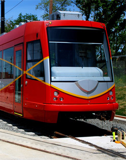
Czech-built version. |
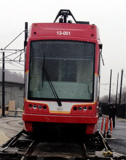
US-built version. Photo from DDOT. |
Clearly, the fronts are a noticeably different. The Czech streetcar has a V-shaped yellow & gray stripe and 3 front-facing lights on each side. The US version has a boxy yellow & gray stripe and 4 front-facing lights per side. Also, the US version has a shell covering the mechanical fixtures on the top, while the Czech version doesn’t.
There are other minor differences to the mechanical systems, and maybe the interior layout. But the easiest way to tell the difference, by far, is the paint job on the front.
Average Rating: 4.9 out of 5 based on 204 user reviews.
January 22nd, 2014 | Permalink
Tags: streetcar, transportation
In an attempt to discredit the concept of streetcars, some opponents erroneously claim that other first-world countries don’t build mixed-traffic rail. So let’s set the record straight: Yes they do. Plenty.

Mixed-traffic tram in Manchester, UK, opened in 2013.
Photo by Howard Pulling on flickr, used with permission.
I’m not an expert on European transit, but it takes about 5 minutes on Google to find numerous examples of recently-built mixed-traffic European trams.
Here’s a (most likely partial) list. The dates in parentheses are either the year trams were reintroduced to the city in question, or the year the specific mixed-traffic segment pictured in the link was built.
That’s actually longer than the list of US cities currently running newly-built mixed-traffic streetcars. As of this writing, that list is exactly two cities long: Portland and Seattle. Granted, it is about to explode, but over the past decade Europe has unquestionably built more mixed-traffic streetcars than the US.
Of course, all transit functions better in dedicated lanes. It’s completely true that many mixed-traffic streetcars in the US would benefit greatly from dedicated lanes, and will only lack them for political will. It’s also completely true that Europe is better at providing transitways for their streetcars more often than the US. None of that is in dispute.
But the fact is, many European cities have indeed recently added new mixed-traffic lines, because whether streetcar opponents care to admit it or not, there are many benefits to rail transit aside from where it runs.
But wait, there’s more
In addition to the true mixed-traffic streetcars listed above, Europe also has an entire category of trams that often run in mixed-traffic that’s completely absent from the US.
Guided tire trams run on rubber tires like a bus, but have a single in-ground track to guide them, as well as overhead wires. They’re a middle ground between buses and streetcars, and are present in mixed-traffic arrangements in multiple cities in France and Italy, at least.
It’s not exactly fair to call guided tire trams streetcars, but neither is it fair to exclude them from a discussion of mixed-traffic European trams.
If a US city wants to prove it’s serious about providing a rail-like BRT experience, they might experiment with one of these. So far, none have done so.
Cross-posted at Greater Greater Washington.
Average Rating: 4.5 out of 5 based on 222 user reviews.
January 13th, 2014 | Permalink
Tags: BRT, streetcar, transportation
Three other American cities in addition to DC will open new streetcar lines this year, and at least 12 more cities are expected to advance construction on lines that will open later.
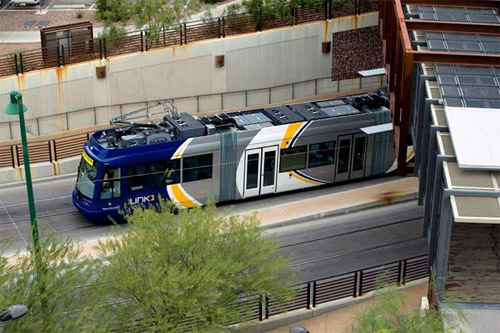
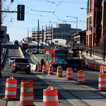
Streetcar undergoing on-street testing in Tucson, Arizona. Photo from the City of Tucson.
The four lines expected to open in 2014 are in DC, Tucson, Seattle, and Atlanta.
Tucson’s Sun Link streetcar will be the first modern rail transit to open in that city.
Seattle’s First Hill streetcar will run next to a cycletrack for much of its length, in an impressive multimodal layout.
Atlanta’s downtown streetcar will be the first modern streetcar to open in the US that doesn’t use the ubiquitous 66′ long streetcar model first popularized in Portland. Instead, Atlanta will use a 79′ long tram similar to the light rail cars in Norfolk.
North of the border, Toronto will shortly begin to use new 99′ long trams on its expansive streetcar network, the largest in North America.
Even more cities will begin construction or continue construction on new lines that won’t open until 2015 or later. They include Charlotte, Cincinnati, Dallas, Detroit, Fort Lauderdale, Kansas City, Milwaukee, New Orleans, Oklahoma City, Tempe, San Antonio, and Saint Louis.
Many other cities, including Arlington, have streetcars that aren’t expected to begin construction yet, but aren’t far behind.
Cross-posted at Greater Greater Washington.
Average Rating: 4.5 out of 5 based on 300 user reviews.
January 9th, 2014 | Permalink
Tags: streetcar, The New America, transportation
In anticipation of the upcoming H Street streetcar, DDOT created this safety video that illustrates how drivers, cyclists, and pedestrians should act once the streetcar begins running.
Cross-posted at Greater Greater Washington.
Average Rating: 4.5 out of 5 based on 232 user reviews.
December 20th, 2013 | Permalink
Tags: streetcar, transportation
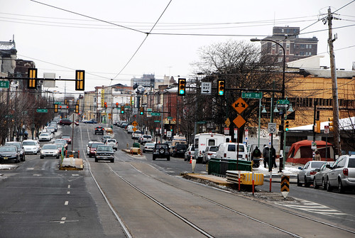
Philadelphia’s streetcar network is the largest and busiest in the mid-Atlantic. It has several interesting features, some of which can help inform the planning for DC’s growing system.
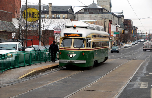
Philadelphia’s Girard Avenue trolley, with island platform.
Philadelphia calls its system trolleys instead of streetcars, because it’s vintage from the original trolley era. While Philadelphia did discontinue many of its original trolley routes, unlike DC they also kept many.
The Girard Avenue trolley line even uses vintage trolley vehicles, originally built in 1947. It also runs in a unique on-street arrangement, with tracks down the center of wide Girard Avenue, and stations in narrow floating medians.
The Girard Avenue trolley’s floating platforms.
The Girard Avenue arrangement is totally different than DC’s H Street layout, which uses a mixture of curbside and full median tracks.
Philadelphia’s center-running tracks result in fewer conflicts with parked or turning cars, which speeds the trolleys down their route. It’s almost-but-not-quite like a dedicated transitway.
Unfortunately, the platforms are too narrow to meet modern disability-accessible design guidelines. If DC were to use a similar arrangement, we’d need wider platforms and thus more street width.
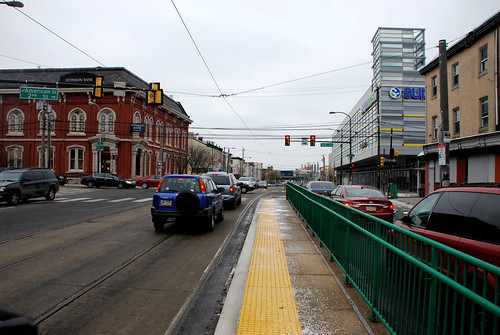
Narrow platform on the Girard Avenue trolley line.
On narrower streets in West Philadelphia, trolleys still run in the center, with bike lanes between the tracks and a row of parked cars.
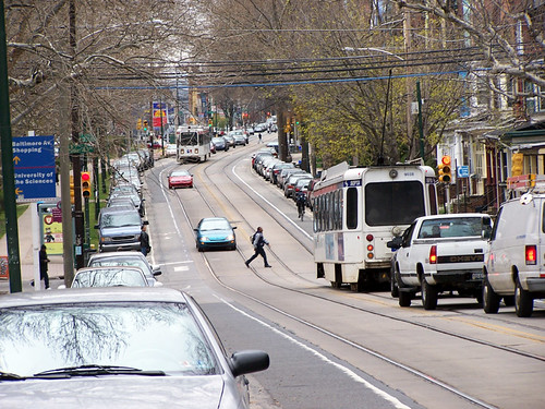
West Philadelphia trolley line.
The trolley subway
Five trolley routes that run on-street in West Philadelphia combine and then move into a dedicated trolley subway to speed through Center City. It’s a great way to maximize the efficiency of the system through its most dense and congested section, while still taking advantage of the flexibility of on-street operations further out.
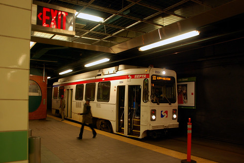
13th Street trolley subway station.
DC once had a short trolley subway too, under Dupont Circle. Today, DC’s reborn streetcar plan doesn’t call for any. They’re hugely expensive, after all. But with the specter of Metrorail capacity constraints looming, and new DC subway lines under consideration, perhaps someday a streetcar subway could again be appropriate in DC.
What else is there?
I’ve never personally lived in Philadelphia, so my experience with its trolley network is fairly limited. I’m sure there are other interesting features. What did I miss?
Cross-posted at Greater Greater Washington.
Average Rating: 4.6 out of 5 based on 156 user reviews.
December 17th, 2013 | Permalink
Tags: galleries, streetcar, transportation, Uncategorized
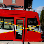
On Friday night, DDOT crews moved the first streetcar to H Street.
The last time streetcars ran on DC streets was January, 1962, just shy of 52 years ago. But don’t expect to catch a ride just yet. The streetcars must now undergo a series of on-street tests before passenger service can begin sometime in 2014.
Many city residents stopped by over the weekend to snap their own pictures. If you haven’t had a chance yet, it’s right there. You can go anytime.
Cross-posted at Greater Greater Washington.
Average Rating: 4.8 out of 5 based on 162 user reviews.
December 16th, 2013 | Permalink
Tags: events, streetcar, transportation
Simply put, the H Street streetcar goes from Union Station to the Anacostia River. But really its route is more complex.
This unofficial schematic shows the line in much more detail, including where it runs in the curb lane versus the middle lane, where there are track crossovers, and the layout of the railyard.
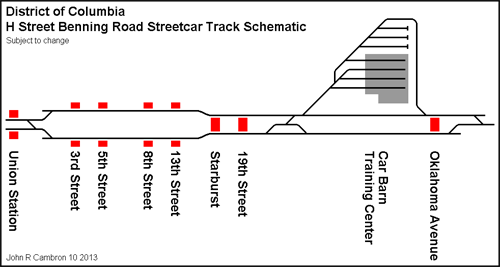
Schematic by John R. Cambron AKA Sand Box John.
Cross-posted at Greater Greater Washington.
Average Rating: 4.4 out of 5 based on 192 user reviews.
November 27th, 2013 | Permalink
Tags: streetcar, transportation
For streetcars to move through traffic, rail tracks have to be free of parked cars. To keep them that way, the rules of the road must be crystal clear for drivers.
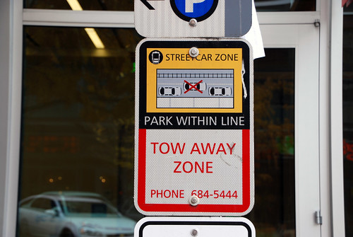
Streetcar parking zone sign, Seattle.
Last week DDOT used a truck for a test-run of the H Street streetcar route, and because of illegally parked cars, the going was slow. But other cities with similar streetcar layouts, like Seattle and Portland, have had a lot of success keeping their lanes clear. How do they do it?
With constant and clear communication to drivers, like the sign pictured here, and with strong enforcement.
Any time you take pavement away from cars, there’s a learning curve. Drivers accustomed to doing as they please have to change behavior. That’s to be expected, and it doesn’t happen on the first day you run your first test truck. But most drivers do fall in line, once they understand what’s changed. That’s how streetcars have worked in other cities.
And if all else fails, ticketing cameras mounted on streetcars, like in San Francisco, would solve any remaining problem in a hurry.
Cross-posted at Greater Greater Washington.
Average Rating: 4.9 out of 5 based on 232 user reviews.
November 25th, 2013 | Permalink
Tags: roads/cars, streetcar, transportation
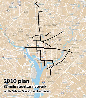
In the latest draft of DDOT’s MoveDC plan, the 37-mile streetcar network originally planned in 2010 becomes a 69-mile “high capacity transit” network.
The new 69-mile network would include DC’s initial 22-mile streetcar system, plus 47 more miles of either streetcar or BRT.
 |
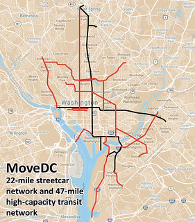 |
| 37-mile network from 2010, and latest MoveDC 69-mile proposal. Base maps from Google. |
The 47-mile network, shown in red on the map, would include 25-miles of dedicated transit lanes, regardless of whether those lines are eventually built as bus or rail. The dedicated lanes would be on 16th Street, North Capitol Street, I-295, M Street SE & SW, and I and H Streets downtown.
Curiously, the proposed streetcar line on Rhode Island Avenue from the 2010 plan isn’t carried forward into MoveDC.
The new plan shows the 14th Street streetcar shifting over to 7th Street, although the details of that line are still in flux. It could still end up on 14th.
Finally, MoveDC also notes several potential extensions to Maryland and Virginia, anywhere a proposed DDOT line approaches the District boundary. Perhaps most notably, there are potential connections across Long Bridge into Arlington, down I-295 to National Harbor, and to Silver Spring.
For Metrorail, MoveDC includes WMATA’s proposal for a new loop subway line through DC, connecting Rosslyn on one end and the Yellow Line bridge on the other.

Map from BeyondDC, using base map from Google.
Overall this is a progressive and ambitious proposal, although the removal of Rhode Island Avenue raises questions. It’s still a draft, so you can comment via the WeMoveDC website.
Cross-posted at Greater Greater Washington.
Average Rating: 5 out of 5 based on 184 user reviews.
November 22nd, 2013 | Permalink
Tags: BRT, master planning, streetcar, transportation
|
Media


Site
About BeyondDC
Archive 2003-06
Contact
Category Tags:
Partners
|


