|
Special Features


Image Libraries


|
|
Blog
Here we are. Donald Trump is America's president. The largest protest in American history greeted his first day. Welcome to Washington and the USA in 2017.

Saturday’s Women’s March. Image from Mobilus In Mobili on Flickr.
Our weekend was momentous
Two days, two gigantic events.
As inaugurations go, Friday's was noticably small. But even a small inauguration is big enough to change the tone of city life.
Security fences partitioned blocks of downtown, and an army of police forces dominated the streets. Many locals stayed away to avoid the logistical and emotional headaches. Parts of the city became eerily dead, while others burst with unusual life, as Trump supporters descended to hotels and tourist areas around the White House.
Washington became a foreign city, its own residents outsiders to a security and tourist project to which we didn't belong, nor feel healthy within.
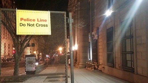
Security barriers in an empty downtown.
During the inauguration itself, Metro ran smoothly. Trump presented a bleak picture of America. Protests raged, mostly peacefully, sometimes not. GGWash's own David Whitehead proved that deescalation works.
The new administration erased climate change from presidential priorities, and disciplined the National Park Service for reporting meager crowds. Joe Biden took Acela home to Delaware.
We went to bed, unsure the country we would wake to find.
And then, on Saturday, three times more people attended the Women's March than Friday's inauguration. Nationwide, at least three million took to the streets.
There was grief and humor and defiance. Mayor Bowser chanted "Leave us alone!, " DC police donned pink hats, and Metro had its second busiest day ever.
In contrast to Friday, Saturday's Washington felt more ours than ever. The city became strangely joyous, as march-goers spread over downtown and the National Mall to reclaim our public spaces, replacing the inauguration's fenced-off security apparatus with revelry lasting well into the evening.
We went to bed with renewed determination.

Image from Andrew Aliferis on Flickr.
Meanwhile, Donald Trump's press secretary brazenly lied, and his counselor hoped to replace the truth with "alternative facts" intended to sow uncertainty and estrange the media.
The policy fights are just beginning
Trump may be the most urban president in history, but his party and his base are vehemently anti-urban. Administration policy seems to be largely under the purview of Vice President Pence, whose small town Indiana roots are decidedly not urban.
They plan dramatic cuts to many federal departments, including the Department of Transportation, where multimodal infrastructure spending will likely decline in favor of tax breaks for construction firms. The Environmental Protection Agency is likely to be gutted, enabling a new round of urban pollution and ending the fight against climate change. HUD raised prices for first-time homebuyers within an hour of Trump's swearing-in. The Department of Justice will no longer pressure police departments over civil rights.

What will the EPA look like in four years? Image from Paul Fagan on Flickr.
Locally, such massive cuts and a proposal to strip benefits from government employees could throw Washington's economy into recession, as jobs bleed out of the city. Or security and military spending could lead to a new boom. Either way, Congress' small government Republicans will override local decision-making in DC.
Nationally, the right is emboldened, while the left is beginning to act like a true opposition.
So, here we are. Donald Trump is America's president. The future of our city and our country is uncertain. We face colossal challenges. But GGWash's mission and values are still worthwhile, and our community is as strong as ever. We'll be here.
 Comment on this at the version cross-posted to Greater Greater Washington. Comment on this at the version cross-posted to Greater Greater Washington.
Average Rating: 4.7 out of 5 based on 201 user reviews.
January 23rd, 2017 | Permalink
Tags: economy, environment, events, government, in general, metrorail, The New America, transportation

A miniature Target is now open in Rosslyn, occupying the ground floor of an office tower. At less than a sixth the size of a typical suburban Target, it shows how retailers are adapting to America’s increasingly urban reality.

Inside Rosslyn’s Target.
The store had a soft opening last week, and an official opening Sunday. At 23, 000 square feet, it’s about the size of a large Trader Joe’s, or a small Safeway. It’s minuscule compared to normal Target stores, which often top 150, 000 square feet.
And yet, it’s got a little of everything, just like a normal Target.

Inside Rosslyn’s Target.
A few years ago, when I lived in a Ballston high rise, I’d have killed to have a Target on the Orange Line. The only department stores I had easy access to were the Macy’s in Ballston and downtown DC. And, for a recent college grad spending way too much on housing, Macy’s wasn’t in my budget for housewares.
Now urban department stores are sprouting everywhere.

Rosslyn’s Target, from Wilson Boulevard.
This is, by my count, at least the Washington region’s fourth fifth urban-format Target. The first opened in the 1990s in Gaithersburg. Then came Columbia Heights in 2008 and Merrifield in 2012, then our first mini Target earlier this year in College Park.
Walmart joined the game beginning in late 2013, with urban stores downtown and on Georgia Avenue.
Smaller stores may be the new normal
It’s not just Target and Walmart looking to get in on this game. Other chains are launching a new breed of mid-size stores, like this mini Target, in a race to fill the urban retail niche.
In 2013, Walgreens opened a new “flagship” store in Chinatown. At 23, 000 square feet, it’s almost exactly the same size as the new Rosslyn Target, and twice a normal Walgreens.

The flagship Walgreens. Photo from Google.
And although their merchandise selections are a little different (the Target has more clothes and housewares, while the Walgreens has more beauty & health products), the Rosslyn Target and the Chinatown Walgreens are clearly evolving towards becoming a similar category of store: The not-quite-department-store, or the 21st Century general store.
Whatever you call it, it’s a growing retail niche.
Comment on this at the version cross-posted to Greater Greater Washington.
Average Rating: 4.4 out of 5 based on 230 user reviews.
October 12th, 2015 | Permalink
Tags: development, economy, The New America
The US Census’ newest county-level population estimates show that between 2012 and 2013, the District of Columbia population grew more than any other metro area county.
Loudoun County grew slightly faster by percentage. But even according to that measure, DC is 2nd.
| County |
2012
population |
2013
population |
Raw
growth |
Percent
growth |
| District of Columbia |
633, 427 |
646, 449 |
13, 022 |
2.1 |
| Loudoun VA |
337, 248 |
349, 679 |
12, 431 |
3.7 |
| Fairfax Co VA |
1, 118, 683 |
1, 130, 924 |
12, 241 |
1.1 |
| Montgomery MD |
1, 004, 476 |
1, 016, 677 |
12, 201 |
1.2 |
| Prince George’s MD |
881, 419 |
890, 081 |
8, 662 |
1.0 |
| Prince William VA |
430, 100 |
438, 580 |
8, 480 |
2.0 |
| Anne Arundel MD |
550, 175 |
555, 743 |
5, 568 |
1.0 |
| Baltimore Co MD |
817, 682 |
823, 015 |
5, 333 |
0.7 |
| Howard MD |
299, 356 |
304, 580 |
5, 224 |
1.7 |
| Arlington VA |
221, 275 |
224, 906 |
3, 631 |
1.6 |
| Stafford VA |
134, 251 |
136, 788 |
2, 537 |
1.9 |
| Charles MD |
150, 710 |
152, 864 |
2, 154 |
1.4 |
| Alexandria VA |
146, 839 |
148, 892 |
2, 053 |
1.4 |
| Frederick MD |
239, 520 |
241, 409 |
1, 889 |
0.8 |
| Spotsylvania VA |
125, 772 |
127, 348 |
1, 576 |
1.3 |
| Fauquier VA |
66, 526 |
67, 207 |
681 |
1.0 |
| Baltimore city MD |
622, 417 |
622, 104 |
-313 |
-0.1 |
Cross-posted at Greater Greater Washington.
Average Rating: 4.4 out of 5 based on 231 user reviews.
March 27th, 2014 | Permalink
Tags: demographics, The New America
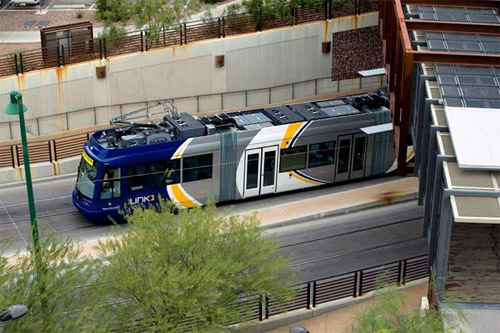
Three other American cities in addition to DC will open new streetcar lines this year, and at least 12 more cities are expected to advance construction on lines that will open later.
Streetcar undergoing on-street testing in Tucson, Arizona. Photo from the City of Tucson.
The four lines expected to open in 2014 are in DC, Tucson, Seattle, and Atlanta.
Tucson’s Sun Link streetcar will be the first modern rail transit to open in that city.
Seattle’s First Hill streetcar will run next to a cycletrack for much of its length, in an impressive multimodal layout.
Atlanta’s downtown streetcar will be the first modern streetcar to open in the US that doesn’t use the ubiquitous 66′ long streetcar model first popularized in Portland. Instead, Atlanta will use a 79′ long tram similar to the light rail cars in Norfolk.
North of the border, Toronto will shortly begin to use new 99′ long trams on its expansive streetcar network, the largest in North America.
Even more cities will begin construction or continue construction on new lines that won’t open until 2015 or later. They include Charlotte, Cincinnati, Dallas, Detroit, Fort Lauderdale, Kansas City, Milwaukee, New Orleans, Oklahoma City, Tempe, San Antonio, and Saint Louis.
Many other cities, including Arlington, have streetcars that aren’t expected to begin construction yet, but aren’t far behind.
Cross-posted at Greater Greater Washington.
Average Rating: 4.9 out of 5 based on 280 user reviews.
January 9th, 2014 | Permalink
Tags: streetcar, The New America, transportation
Having recently added new rail service to Norfolk and Lynchburg, Amtrak is now beginning planning to extend service to Roanoke.
The plan is simply to extend the highly successful Lynchburg train a few miles further southwest. But since Roanoke hasn’t had rail service in decades, it will take 3-4 years to get everything ready.
Even if progress is slow, it’s exciting to see American intercity rail become popular again.

Amtrak’s route to Roanoke.
Cross-posted at Greater Greater Washington.
Average Rating: 4.7 out of 5 based on 282 user reviews.
August 22nd, 2013 | Permalink
Tags: intercity, maps, The New America, transportation
|
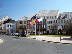
Main Street, Kentlands |
It’s been 25 years since development started at Gaithersburg’s Kentlands, America’s first year-round new urbanist community. With a quarter century of experience under our belt, not to mention a major shift in American development patterns, what have we learned?
When new urbanism hit the big time in the late ’80s and early ’90s, central cities were still declining, and suburbs were still focused around enclosed shopping malls. Generations of Americans had grown up driving around the suburbs, thinking of urban places as crime-ridden ghettos.
New urbanism changed all that. Wherever a new urbanist neighborhood opened, a nice-looking and safe walkable urban place suddenly became accessible to the suburban masses, many of whom had never had one before.
New urbanism reintroduced Americans to the concept of urban living. And as recent history tells us, once we learned urban living was an option, people flocked to it.
New urbanism’s strength is its weakness
But all walkable communities aren’t created equal, and the very thing that made new urbanism initially successful also became its most limiting weakness.
In older urban areas, new urbanist development is indistinguishable from well-designed regular infill. So although new urbanism has many infill projects to its name, the term is more strongly associated with suburban development like Kentlands, where it’s more distinct.
Those suburban new urbanist communities have usually turned out to be internally walkable, but poorly connected to their auto-oriented surroundings. Without the critical mass of a huge walkable city surrounding them, they hit a ceiling. Residents can walk to a corner store and a few cafes, but most of them still need cars to get to work, or really to go anywhere more than a half mile away.
So new urbanism boomed, but those who bought into the concept of urban living quickly deduced that larger and older urban communities offer a superior experience. Kentlands is nice, but compared to places like DC, Arlington, or Silver Spring it’s still relatively isolated, homogeneous, and car-dependent.
Thus, in a twist of fate, new urbanism’s main lasting benefit may be that it’s a gateway for suburbanites to become urbanites — a baby step towards regular urbanism. A necessary step, to be sure, but one quickly passed by.
We do still need new urbanism
Despite the fact that regular urbanism is back, and that new urbanism is no longer the progressive cutting edge of city planning, we still need it in the suburbs.
New growth at the suburban fringe will continue to happen, after all. It always has and it always will; even Dupont Circle was once rural. So we will need a steady stream of new suburban places that are more walkable, more mixed-use, less dependent on the 20th century highway paradigm that has failed so badly. New urbanism remains ideally suited for that purpose.
Regardless of whether or not it’s true that we still need new urbanism to build good cities, we clearly still need it to build better suburbs.
Cross-posted at Greater Greater Washington.
Average Rating: 4.4 out of 5 based on 203 user reviews.
August 21st, 2013 | Permalink
Tags: history, The New America
|
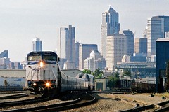
An Amtrak Cascades train leaves Seattle. Photo by KurtClark on flickr. |
Rail use in America continues to climb ever higher. In July, Amtrak posted its busiest ridership month ever. But what are the busiest individual routes?
Let’s take a look. Here are the 10 highest ridership Amtrak routes, as of July, 2013:
Number 1: Northeast Regional
July, 2013 ridership: 687, 331
Number 2: Acela Express
July, 2013 ridership: 276, 477
Number 3: Pacific Surfliner (Southern California)
July, 2013 ridership: 271, 517
Number 4: Capitol Corridor (Northern California)
July, 2013 ridership: 140, 533
Number 5: Keystone Service (NY to Harrisburg, PA)
July, 2013 ridership: 123, 874
Number 6: San Joaquin (Central California)
July, 2013 ridership: 117, 348
Number 7: Empire Service (Upstate New York)
July, 2013 ridership: 99, 801
Number 8: Cascades (Pacific Northwest)
July, 2013 ridership: 85, 565
Number 9: Hiawatha (Chicago to Milwaukee)
July, 2013 ridership: 79, 423
Number 10: Lincoln Service (Chicago to Saint Louis)
July, 2013 ridership: 66, 461
Correction: An earlier version of this story listed ridership data as being for the full fiscal 2013 year. Data is for July, 2013 only.
Cross-posted at Greater Greater Washington.
Average Rating: 4.7 out of 5 based on 162 user reviews.
August 16th, 2013 | Permalink
Tags: intercity, The New America, top10, transportation
Here are two pictures of the same block of H Street, taken 10 years apart.
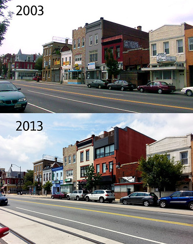
H Street NE between 5th and 6th streets.
Average Rating: 4.4 out of 5 based on 185 user reviews.
July 29th, 2013 | Permalink
Tags: galleries, The New America
Almost 4 in 10 DC households are car-free, and even more are car-light. That’s not because DC is full of car-hating zealots; it’s because life is simply more convenient that way, when the conditions are right.
When 5 minutes of walking, along a pleasant and safe sidewalk, can get you to most of your daily needs, and cycling or high-frequency transit can get to the rest, driving is more of pain than convenience. Especially when you factor in battling for parking and road rage, not to mention cost.
So when the Coalition for Smarter Growth started putting together Walkable Living Stories, about how and why so many DC residents go car-free or car-light, I wanted to participate. Here’s my story:
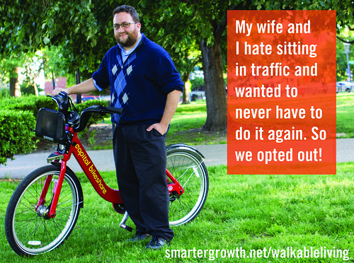
Photo from CSG.
“My wife and I hate sitting in traffic and wanted to never have to do it again. So we opted out! When we selected our apartment, we intentionally picked one in the densest part of DC. Within two blocks of our apartment we have a grocery store, convenience mart, dry-cleaner, hardware store, and several cafes. So almost all our daily errands are on foot, or Capital Bikeshare. My commute is on the 16th St. bus line, where buses come every few minutes (more often than Metro trains!), so we never have to wait long. And we never have to look for parking, because we don’t need any! Our apartment costs more than one in the suburbs would, but we don’t have a car payment, nor an insurance payment, nor any gasoline bills. We do occasionally rent cars for out-of-town trips, but that’s much less hassle and cost than car ownership.”
For more about CSG’s Walkable Living Stories project, visit their website, or see today’s big GGW post.
Average Rating: 4.7 out of 5 based on 258 user reviews.
June 19th, 2013 | Permalink
Tags: people, The New America, transportation
|
Arlington, urbanizing. |
Salon.com recently interviewed me for a story about emerging suburban downtowns. Here are some snippets:
Fact: People want to live in walkable urban places. Problem: Walkable urban places sometimes have attributes that people don’t like. Solution: Build new walkable urban places out in the suburbs. Result: A whole new type of place that offers the city experience without the actual city…
Some of them are in places like Rosslyn and Bethesda — close-in suburbs that developed an organic urban physicality over time… But the newer ones are in towns as far away as Reston and Tysons Corner in Virginia…
Daniel Malouff, editor of the blog BeyondDC, sees these WalkUPs as more like “starter cities” for suburbanites. “A place like Reston can introduce people who have grown up with suburbia to the idea of urbanism, ” he says…
But does density and walkability alone make something urban? Though these outer-ring WalkUPs display many of the technical metrics of a city, most have an unmistakable suburban flavor…
But if WalkUPs promise an urban experience, it’s fair to ask what kind of urban experience they’re offering. “Any definition of urban you can think of, these places would qualify, ” says Malouff. “But there’s clearly a difference.”…
The discussion about the authenticity of newly-built urban places has been going on since at least the late 1980s, when New Urbanism started to become a thing. On the one hand, new-built town centers are usually a touch sterile (especially if they’re built by a single developer all at once), and often disconnected from other urban places. On the other hand, they get better with age, and even Adams Morgan was a new place once upon a time.
I agree with the criticism that these places can sometimes feel forced, especially the ones like Bowie Town Center that are basically malls without a roof. But given the reality that our metropolitan areas jumped the suburban shark decades ago, and that millions of suburbanites cannot be expected to convert to Jane Jacobs urbanists all at once, whatcha gonna do? What other solution is there at the regional scale, except for incremental change in the right direction?
Our metropolitan areas aren’t going to change overnight, and we wouldn’t want them to anyway (it wouldn’t feel “real”). If our regions are going to change, it will be an incremental change.
That’s what’s so ironic about these town centers. Individually some of them lack the organic progression that would make them feel real. But taken in the regional context they are a legitimate step in precisely that sort of progression, part of a decades-long evolution of our metropolitan areas.
So whatever legitimate and true criticism of them is leveled, they’re still a good and necessary thing. The challenge for urban planners in the 21st Century will not be how to fight against these town centers, but rather will be how to improve them, and how to incorporate them in to a working, interconnected region.
Average Rating: 4.9 out of 5 based on 237 user reviews.
September 24th, 2012 | Permalink
Tags: master planning, The New America
|
Media


Site
About BeyondDC
Archive 2003-06
Contact
Category Tags:
Partners
|


