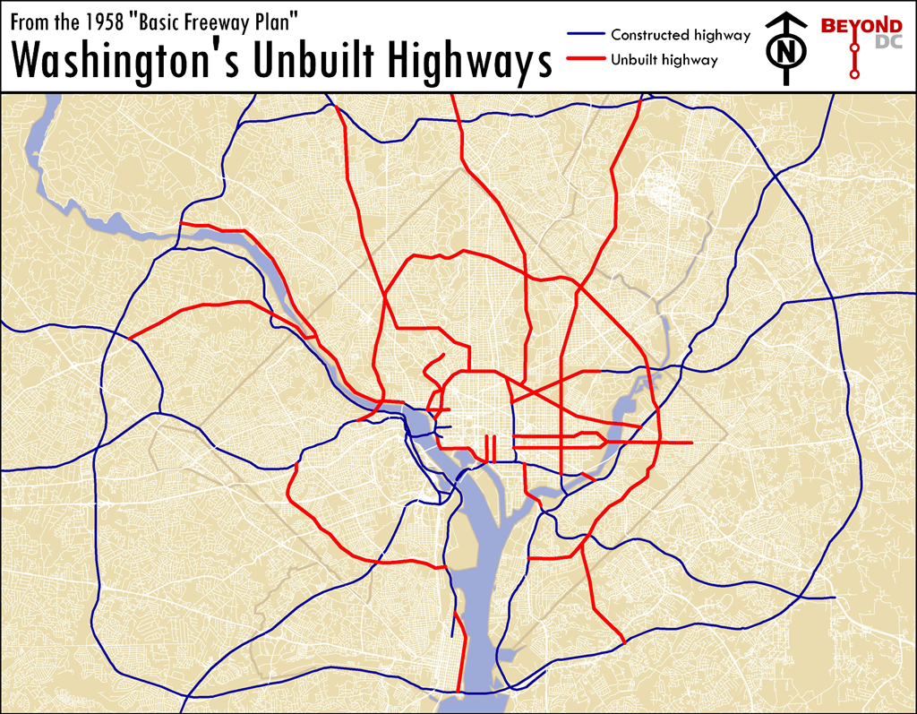
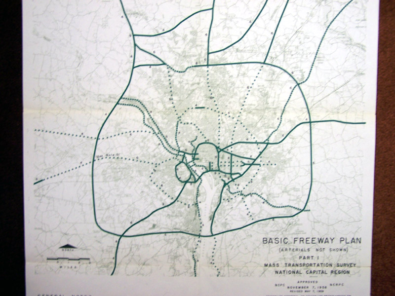
This is a map of the Washington that almost was. If mid-century planners, dedicated as they were to driving and the clearance of historic neighborhoods, had their way. It is a map of the highway network proposed for Washington during initial planning of the Eisenhower Interstate System, in 1958.
Each of these canceled highways, shown in red on the map, has its own story. Some were canceled due to civic activism, others because later proposals in the 70s preempted them, and others due to good ol’ fashioned sanity. Because they were never built, entire neighborhoods that might have been wiped out were saved, downtown was never physically cut off from its surroundings (except to the south), and millions of dollars were reallocated to construction of the Metro. Because these highways were canceled, Washington is the beautiful, walkable, vital city that we know and love today.
The problem with Washingtonian magazine is that it really should be called Suburbia Magazine. As far back as I remember, Washingtonian has primarily covered suburban topics, and done so with a suburban outlook. The latest example dropped this morning, with a story about the cost of commuting by Metro versus driving, in which it was assumed that everyone already owns a car, that the only way anyone accesses Metro is to drive to stations, and that the only stations anybody ever uses are end-line park-and-rides.
To Washingtonian’s credit, they redacted that particular story after universally negative comments tore Fairfax County-sized holes in their logic, but the basic problem remains, and it is obvious that this will not be the last time they approach a story with a clear suburban bias.
Not there’s anything necessarily wrong with a magazine focusing on the suburbs, just that, y’know, don’t call it Washingtonian, and don’t claim to represent the entire region. If the same story had appeared in Loudoun Magazine, nobody would have objected.
Average Rating: 4.4 out of 5 based on 230 user reviews.
At approximately 2:25 this afternoon, the WMATA board approved next year’s budget, including the assortment of fare hikes that were proposed in May and designed to maintain the system and avoid cuts to service. In today’s entry at the Washington Post Local Blogging Network, I describe why fare hikes were Metro’s best option.
Average Rating: 4.5 out of 5 based on 201 user reviews.
The Washington Post Local Blogging Network features a post today co-written by Catherine Hudgins and Chris Zimmerman, WMATA Board representatives from Fairfax and Arlington Counties. In the letter they respond to Virginia transportation secretary Sean Connaughton’s demand that Northern Virginia elected officials relinquish two WMATA Board seats to instead be appointed by the administration in Richmond.
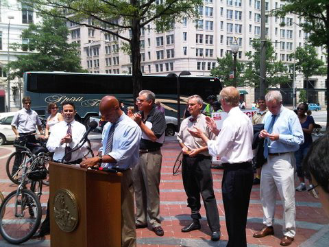
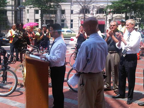
At 2:00 p.m. today, the District of Columbia officially opened the new Pennsylvania Avenue bike lanes. All the cool kids attended the opening ceremony, including Mayor Fenty, US DOT Secretary Ray LaHood, Congressmen Blumenauer and Oberstar, and DDOT Director Gabe Klein, among others.
Friend of BeyondDC David Patton swung by and snapped these pictures:
From left to right: DDOT Bicycle Program Coordinator Jim Sebastian, DDOT Director Gabe Klein, DC Mayor Adrian Fenty (speaking), USDOT Secretary Ray LaHood, Congressman Earl Blumenauer (D-OR), DC Councilman Jack Evans, DC Councilman Tommy Wells.
DDOT Director Gabe Klein introduces a Bixi bike-sharing bicycle, to the applause of USDOT Secretary Ray LaHood.
Thanks a million, David!
Update: DDOT has additional photos in a Facebook gallery. – June 23
Average Rating: 4.4 out of 5 based on 212 user reviews.
This evening the Fairfax County Board of Supervisors will hopefully approve a long range redevelopment plan for Tysons Corner. In a post at the Washington Post Local Blogging Network, I argue that the only sensible action is to raise density in Tysons to the point where it can begin to function like a genuine city, where walking and transit are as easy or easier than driving.
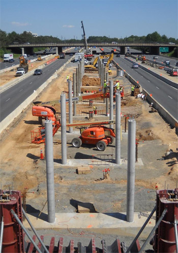
This month’s Silver Line construction newsletter is out. It includes this picture by project engineer John Odorisio of the Wiehle Avenue station, under construction in the median of the Dulles access road.
Average Rating: 4.6 out of 5 based on 224 user reviews.
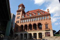
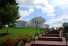
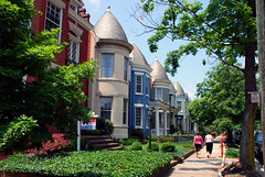
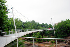
Last month I found myself in Richmond, VA, Charlotte, NC, and Greenville, SC. My photos and thoughts about each city are available in threads at the SkyscraperPage photography discussion forum (links below) or via flickr.
All three are interesting cities. Richmond may have been the capital of the Confederacy, but structurally it’s a mid-Atlantic city and feels much like a smaller version of Washington (or rather, Washington 10-15 years ago pre-gentrification). Charlotte has gorgeous skyscrapers and a nifty new light rail line, and although Greenville is smaller, it has one of America’s coolest downtown parks.
Here are a few samples:
Main Street Station, Richmond
Virginia State House, Richmond
Rowhouses in The Fan neighborhood, Richmond
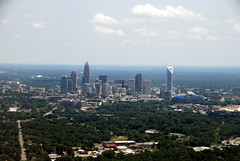
Charlotte’s skyline, from airplane
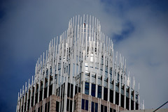
Bank of America skyscraper crown, Charlotte
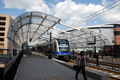
Light rail station, Charlotte
Public art, Greenville
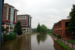
Downtown riverwalk, Greenville
Reedy River bridge, Greenville
Average Rating: 4.8 out of 5 based on 258 user reviews.


