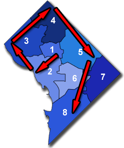
Local DC politics revolve around eight unique wards, but remembering which ward is which can sometimes be difficult. It might be easier if wards were named for neighborhoods rather than numbered, but we play the hand we’re dealt.
I use the trick in the image at right to keep track of wards. It’s simple: Starting with Ward One in the center of the city, drawing a clockwise spiral results in a line that goes through the wards in ascending order.
If you can remember the spiral, you can remember which ward is which.
Average Rating: 4.4 out of 5 based on 258 user reviews.
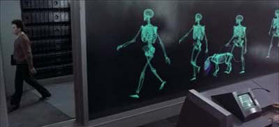
After I heard about the terrorist plot to bomb Metrorail, it wasn’t long before I remembered the movie Total Recall. Specifically the scene where Our Hero, Arnold Schwarzenegger, walks through a security x-ray while entering a subway station.
Just to be clear, there is no real-life proposal to do this. But it’s not hard to imagine the rush to add security that would likely follow a successful attack. Can you imagine a future with a set of these at Metro Center? Would you still ride if so?
Average Rating: 4.8 out of 5 based on 236 user reviews.
Construction of CityCenter DC, the massive mixed-use complex slated to replace the parking lot where the old convention center used to stand, will finally – finally – start construction in April, reports Washington Post.
When CityCenter opens it will bring about 225, 000 square feet of new retail with it. For comparison, the Gallery Place development has about 250, 000 square feet, including the movie theater and bowling alley. Clearly, CityCenter will be a big deal.
The key question, I think, is whether or not CityCenter and Gallery Place will compete as individual destinations, or form a single cohesive downtown shopping district. Can these two massive retail anchors be leveraged to draw shoppers onto the intervening blocks, making them equally vibrant? The city would benefit greatly if so. Not only in the strictest sense of increased sales tax revenue, but also in a more cultural sense: People might start to think of the whole of downtown DC as a destination, as opposed to thinking that way of just a few specific places downtown.
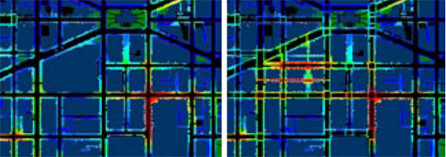
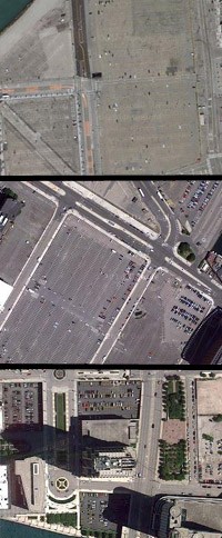
Consider this interesting pair of maps, produced as part of the CityCenter design guidelines (pdf):
Retail visibility near Gallery Place and CityCenter. Brighter colors indicate higher levels of visibility.
The maps show the same section downtown before (left) and after (right) completion of CityCenter. Mount Vernon Square is at the top, Gallery Place is at bottom right, and CityCenter occupies the large block in the left image that’s broken up into several smaller blocks in the right image. The colors indicate the number of entrances to retail establishments visible from that location on the sidewalk, with brighter colors being more. Essentially, the brighter the color, the more retail is on that street.
Unfortunately, it appears that the heaviest concentrations of retail along 7th and I Streets won’t be well connected, mainly because the intersections at H and 8th and I and 7th are too sparsely retailed. There are already large, contemporary buildings at both those intersections, so it’s unlikely the solution will be full redevelopment.
What might work? Complementary signage would help, but probably wouldn’t be enough on its own. Outdoor sidewalk vendors might do the job, but both I and H have sidewalks that are too narrow; the city would have to rebuild the streets to accommodate booths.
One idea I’m fond of would be to take the signage idea a few steps further and install a series of matching public art displays along all the streets in the area, connecting the two nodes. If the art installation were large and visible enough (ceramic pandas probably wouldn’t do the trick), shoppers would soon get the message that seeing that art display meant “shops and entertainment are here, ” which might be enough to persuade more people to walk between CityCenter and Gallery Place.
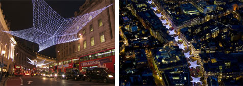
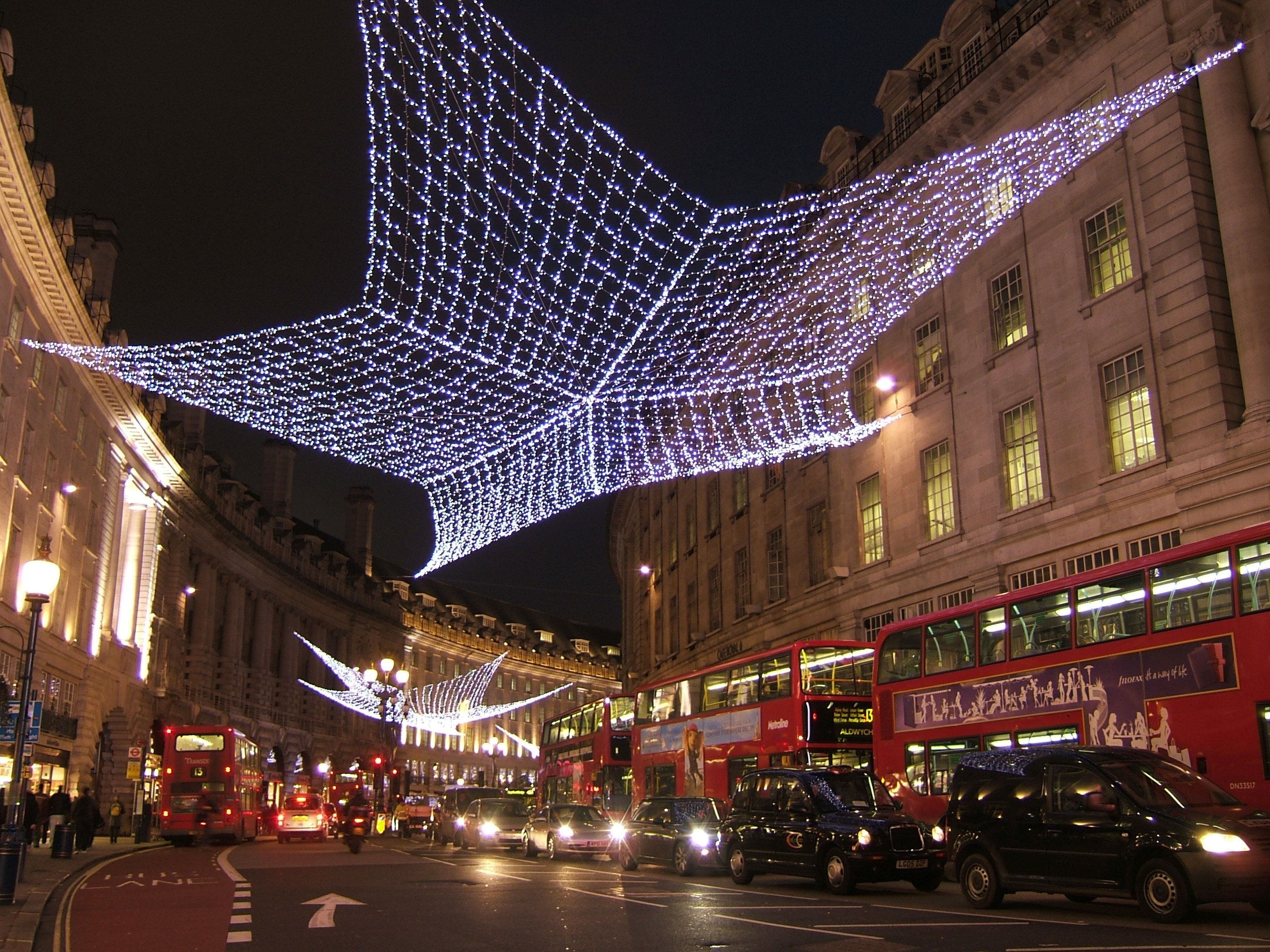
London’s Regent Street uses this strategy to great effect. As the photos below show, anyone who sees the light installation knows exactly where they are and what to expect.
Regent Street, London. Left image from wiki, right image from Jason Hawkes.
Even that may not be enough, though. There’s really no substitute for providing people with a real destination between CityCenter and Gallery Place.
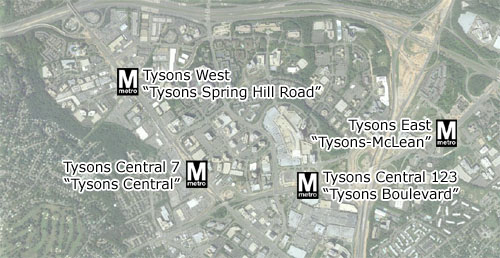
Throughout the planning stages of the Silver Line, the four Metro stations in Tysons Corner have been designated by purely descriptive names. Now that construction is well under way, it’s time to consider what those stations should permanently be called. Metro station names have a way of defining their neighborhoods, so it’s an important question.
The Fairfax County Department of Transportation proposes this:
Original descriptive names on top, proposed new names on bottom in quotes.
Tysons East would become “Tysons-McLean”, Central 123 would become “Tysons Boulevard”, Central 7 would be “Tysons Central”, and Tysons West would be “Tysons Spring Hill”.
As the Washington Post notes, the new proposed names are certainly better than the originals, but they lack a certain catchiness. They’re headed in the right direction, but attaching the word “Tysons” in front of every single one makes them all seem overly contrived. These still seem more like manufactured descriptive terms than the names of real places.
Can we do better? The new names won’t be officially adopted until some time in 2011, so there’s plenty of time to influence the process.
One option might be to simplify Fairfax’s suggestions so they roll off the tongue a little easier: “McLean”, “Tysons Boulevard”, “Tysons Central”, and “Spring Hill Road”. Another option might be to take my suggestions from 2008 and go with “Scott Run”, “Galleria Center”, “Westpark”, and “Spring Hill”.
Or maybe there are even better ideas floating out there. What do you think?
“Dan changes the subject and suggests that scrapping the height limit is entirely unworkable for political reasons. That’s obviously true; I have no illusions about the likelihood of this happening. And undoubtedly, if some allowance were made for taller buildings, it would involve all kinds of compromises and decidedly non-economic negotiations.”
So when it comes down to discussing actual policy prescriptions, we come to the same conclusion. Ryan thinks practical considerations are “changing the subject” and I think they’re “holistic thinking”, but that’s just semantics. True, our biases for what we perceive as most important influence how many and what sort of trade-offs we’re willing to make in an ideal situation, but after cutting through both our bullshit, we find that we’re largely on the same side regarding what the city should actually be trying to do.
So how do we get there?
Average Rating: 4.6 out of 5 based on 161 user reviews.
Parking lots on the fringes of downtown San Francisco, Boston and Chicago.
Ryan Avent says he has a hard time taking my views on the height limit seriously until I honestly grapple with the trade-offs the limit involves.
Ironic, as I might say the same about him. His response to my suggestion that the height limit may have value that his strictly numbers-based approach doesn’t take into account was to repeat the same economic argument over again, as if the non-economic trade-offs don’t matter.
When I say we should raise the height limit in some places but not others, I’m balancing economic, urbanist and political needs. When Ryan says we should raise it wholesale, he’s thinking in one dimension.
Further, there are real holes in his theories about urban development. In response to my claim that the height limit induces development in areas that would otherwise be underdeveloped such as NoMa, Ryan claims that eliminating the height limit would actually lead to increased development there because it would free up marginal areas for less expensive building types.
On paper that theory might make sense, but in reality it never happens that way.
What actually happens in cities with unlimited vertical development potential is that they end up with a lot of tall towers surrounded by surface parking lots. Eliminating the height limit raises the potential land value of every parcel in a given area, so that developers can’t justify building short buildings. Instead of filling in underdeveloped parcels with whatever development fits or whatever the market calls for, builders “bank” land by leaving it undeveloped until they can justify a skyscraper. The result is that every large city in America except New York and Washington is scattered with parking lots.
If we raise the height limit, on the ground experience from every other city in the country tells us that NoMa won’t develop at all until land owners think it’s ready for skyscrapers.
This may not fit academic models of how urban economics should work, and perhaps it is illogical, but it is absolutely how things do work, like it or not.
But the biggest problem with Avent’s position is practical: Getting Washingtonians to agree to something as radical as changing the defining regulation of our city will take a more holistic approach than he seems willing to accept.
There are real trade-offs to raising the height limit that a strictly economic model doesn’t address. Trade-offs like the quality of the pedestrian experience, like how we develop the city’s neighborhoods, or like the emotional value many perceive in having a capital city where economic speculation is specifically checked in order to maintain a distinct monumental civic core. These issues matter to a great number of Washingtonians, though it may be hard to attach monetary values to them.
Ryan talks very intelligently about economics, but at its root this is not an economic question. It’s a political one, and it is not likely that Ryan’s proposals will be taken seriously by decision makers unless he grapples with the non-economic trade-offs that raising the limit involves.
I think that’s too bad, because we could be moving this discussion forward based on the common ground we do have, and figuring out how to make strategic changes to the limit actually happen. Instead we’re stuck in ivory towers on the ideological fringe, arguing in circles and hoping for a Hail Mary.
Average Rating: 4.4 out of 5 based on 150 user reviews.
Washington’s height limit has always been a subject of much debate. The question of whether or not we should keep it or allow taller buildings seems to come up in the local blogosphere about once per year. So I was not surprised to find Matt Yglesias saying:
“Office rents in downtown Washington, DC are now higher than in Manhattan. Normally what happens when you get high rents is that people respond with bigger buildings. Which is why Manhattan has such big office buildings. DC office buildings, by contrast, are quite short. So are developers working on responding to the high demand by building taller buildings? Of course not! Taller buildings are illegal in Washington DC. Consequently, instead of building up real estate developers in the DC area build “out, ” putting more and more jobs in the suburbs.”
A few points:
Actually, developers are working on responding to the high demand by building taller buildings. What will become the tallest building in the Washington region is under construction right now in Rosslyn, and the second and third tallest are planned nearby. Two of those three are office buildings.
While true that Rosslyn is not technically part of “downtown Washington”, it is hardly a suburb in the traditional sense. It’s as close to the White House as Capitol Hill, and is fully urban. Functionally speaking it is part of the regional core in every way that matters, regardless of which side of a map’s line it sits on. Ballston, Crystal City, Alexandria, Bethesda and Silver Spring are much the same, although you might call them “uptowns” since they are a little more distant.
The sort of businesses likely to pick genuinely suburban locations such as Reston or Gaithersburg over the region’s myriad urban options would likely do so even if Washington had no height limit. Even New York and Chicago have expansive suburban office centers.
While it may be true that Farragut Square is built out, there are large areas of downtown Washington that are not. The NoMa Triangle and what you might call the greater Ballpark area are woefully underbuilt, and are capable of accommodating scores of millions of square feet of new development, if only developers would build. It is not the height limit that keeps these areas underbuilt.
“But the bigger cost is in terms of dynamism. Industry towns are dull places, especially when the industry in question is as dull as government. Washington’s height limit means that there is room in the city for little other than the rich corporate interests and the kinds of cultural amenities favored by rich corporate interests. With the height limit in place, there is little risk of Washington becoming as vibrant or as innovative as rival cities to which it so regularly compares itself.”
Interesting point. I don’t think adding office workers from slightly different industries in somewhat taller buildings would have much effect on downtown’s vibrancy. After all, downtown is already plenty vibrant from nine to five. I do however think downtown’s lack of residents is a big problem, and is why it empties out after five p.m. That’s why I support the idea of a height bonus for residential uses downtown, which I think would do more for downtown’s vibrancy than filling it with even more people who leave at 5:00.
But since we’re talking about vibrancy, I want to bring up another point I’ve discussed before: That spreading office growth around the city’s neighborhoods would increase their vibrancy. If it is true that mixed land uses create urban vibrancy, and certainly that is true, then it works both ways. Residential uses add vibrancy to commercial areas AND commercial uses add vibrancy to residential areas. If indeed increased vibrancy and local diversity is a goal for our city, and I think it should be, that argues very strongly for not concentrating all of our office growth downtown, and for instead establishing a regulatory environment that spreads office uses around to create the maximum number of mixed-use neighborhoods.
If that means more people can live and work in the same neighborhood without lengthy and costly commutes, then hey, bonus.
Raising Washington’s height limit is a favorite topic of area economists, and a top fear of preservationists. I count myself as a moderate on the issue. I see real value in keeping the height limit that is not necessarily reflected in the numbers approach Yglesias and Avent favor. On the other hand, I think tall buildings can be an important part of the built environment, and are completely appropriate for many urban contexts.
I think the issue calls for a scalpel rather than a hatchet. Yes, let’s allow taller buildings, but rather than applying a one-size fits all solution to the whole downtown, let’s raise the limit carefully in the places where and the ways in which it will do us the most good. Use a height bonus to increase residential diversity downtown, or to encourage investment in Anacostia, or to find a developer who will build air rights buildings over I-395. Let’s absolutely do those things. But let’s not needlessly erase one of the most unique and interesting things about Washington in a misguided quest to make sure all office space is located within a single two-mile diameter circle.
Average Rating: 4.6 out of 5 based on 227 user reviews.
It seems our message was received. The Post published a follow-up piece on Sunday with quotes from 11 individuals. Out of the 11 total responses, 8 mentioned pedestrian or cyclist issues. The piece closed with the quote I submitted personally:
“Any intersection where pedestrians are treated as second-class citizens. Street design is not all about getting cars through quickly.”
It’s important that proponents of multi-modalism not allow the windshield perspective to dominate public discourse about transportation. If we don’t speak up, we won’t be heard. To those of you who responded: Good work getting the word out. To the Post and Mr. Halsey: Thanks for hearing us.
The Autumn Streets series offers a once-a-week photographic tour of a major street in DC. Last week was 16th Street. Today’s installment: 14th Street, from Columbia Heights to Pennsylvania Avenue.
View the photos in the flickr slideshow below, or with picture-by-picture narration in a thread at SkyscraperPage forum.
Average Rating: 4.6 out of 5 based on 292 user reviews.


