|
Special Features


Image Libraries


|
|
Blog
Longfellow Triangle is one of many lightly used leftover spaces on the L’Enfant grid. With some creative thinking, the city could turn it into a more useful and enjoyable public space.
The triangle is bounded by Connecticut Avenue, Rhode Island Avenue, 18th Street, and M Street. While it would make sense to have a circle there, one never developed, likely because Rhode Island Avenue doesn’t carry through, but rather ends at the intersection. The triangle’s mirror image on the grid, where Massachusetts Avenue meets Vermont Avenue, is Thomas Circle.
Currently, Longfellow Triangle is too small to be a useful park, and too isolated by traffic to be a good plaza. But it doesn’t have to be so. Putting a circle there now is impossible, but with a little bit of street reconfiguration it would be possible to make it a bigger and better triangle park.
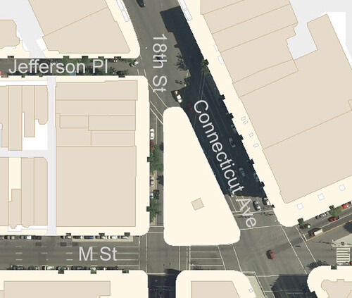
This is a map of the existing conditions at Longfellow Triangle:
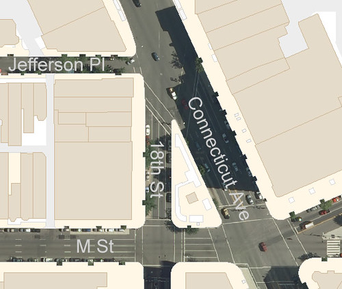
Existing conditions.
Look at how wide the streets are that surround the triangle. Connecticut Avenue is 6 lanes, not counting its generous median. 18th Street is 4 lanes. M Street is 5. All of them have on-street parking, although the parking lanes are used as through lanes at peak periods.
If the city re-purposed the parking lanes on each surrounding block and used that width to add to the triangle, the park space could be dramatically enlarged with little reduction in street capacity. On Connecticut Avenue the median could be re-purposed as well, or it could substitute for one of the parking lanes.
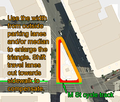
These images show how that might work. In the left image, parking lanes and the Connecticut Avenue median are identified in red and orange. In the right image, the orange spaces are shifted towards the triangle, and the travel lanes are correspondingly shifted outward.
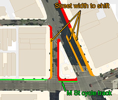 
Shifting the parking lanes towards the triangle would increase usable park space.
The end result would be a considerably larger triangle, one with enough space to begin to take on some of the functions of a true city park. Instead of containing just a row of benches and some shurbs, the space would be large enough for tables, flower beds, and possibly a small lawn. Today’s underused leftover could become tomorrow’s Dupont Circle or Farragut Square.
The down side is that around 30 on-street parking spaces would be lost, and peak period street capacity would drop slightly. This seems a very reasonable price to pay for a greatly enhanced public space.
Other potential complications include the final placement of DDOT’s proposed M Street cycle track and the National Park Service, which is notoriously hard to work with. Neither of these hurdles appears to be a deal breaker, however. The cycle track will only take up a few feet, and if NPS reconfigured Thomas Circle in 2005 they might be willing to reconfigure Longfellow Triangle now.
Obviously this idea would require a considerable amount of additional study before it could be deemed practical. But if it is practical, the upside for urban livability might be tremendous.
Final result: An enlarged park.
 Cross-posted at Greater Greater Washington. Cross-posted at Greater Greater Washington.
Average Rating: 4.6 out of 5 based on 199 user reviews.
August 31st, 2011 | Permalink
Tags: proposal

Spend enough time in Arlington and you will eventually hear reference to something called “Clarendon Circle, ” but take a look at map and it is obvious that there is no circle in Clarendon.
You can’t see it because it’s not there anymore. What used to be the circle, at the intersection of Wilson, Washington, and Clarendon Boulevards, is now a gigantic intersection.
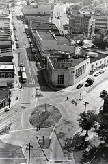
But thanks to the Arlington public library there are plenty of records, including the picture shown at right. The picture shows Clarendon in the early/mid 20th Century, prior to the elimination of the circle or the urban renewal that accompanied construction of the Metro system.
The circle isn’t the only thing in the picture that you won’t find in Clarendon today. The entire block of buildings shown in the center of the photo is gone, replaced by the linear park that tops the Metro station.
Average Rating: 4.7 out of 5 based on 278 user reviews.
August 30th, 2011 | Permalink
Tags: galleries, history
Last week the DC Office of Planning completed its review of two out of the four Walmarts proposed in the city. The Brightwood and New York Avenue stores are by-right developments, meaning the zoning code allows them by law and so the planning department’s review was limited. Large Tract Review (LTR) developments, meaning they comply with the zoning code but for other reasons are required to go through a multi-agency review process. Having passed the OP portion of the review, it’s now very likely that these stores will be built in the forms shown in the images below. Additional details are available for both stores.
Brightwood store:


New York Avenue store:
Average Rating: 5 out of 5 based on 265 user reviews.
August 29th, 2011 | Permalink
Tags: development
Hurricane Irene is expected to be a big deal. The New York subway is already planning to suspend service on Saturday. The hurricane isn’t expected to be as bad in DC as in NY, so WMATA’s plans are correspondingly less severe.
So far WMATA says they are not planning any suspensions of service. However, *if* things become worse than expected, Metro’s contingency plan will be to operate under its blizzard plan and suspend above-ground service. In the event that happens, the service map will look like this:

Average Rating: 4.7 out of 5 based on 275 user reviews.
August 26th, 2011 | Permalink
Tags: events, metrorail, transportation
One of the most basic rules of urban design is that pedestrians need things to look at. Good walking cities are by definition visually messy cities. For this reason, many urbanists are hesitant to support strong sign control regulations. Signs provide things to look at, after all.
When Greater Greater Washington discussed illegal signs at the Uline Area earlier this month, many of the comments suggested that the signs should be allowed, or that the city shouldn’t waste time enforcing sign rules.
I do think there is something to be said for a colorful streetscape, but it’s easy to say that from the vantage point of an already heavily-regulated environment. A handful of illegal signs might very well improve the visual diversity of a street, but if we eliminated sign regulations entirely is a “handful” what we would get?
In a previous job I worked in the zoning division of a local planning office. Part of my job was to process certain types of sign applications. Whenever I started to feel like I was wasting my time, I looked over to this image, which I kept tacked to my wall. It was, and is, a healthy reminder that seemingly mundane regulations do make a positive difference to our built environment.
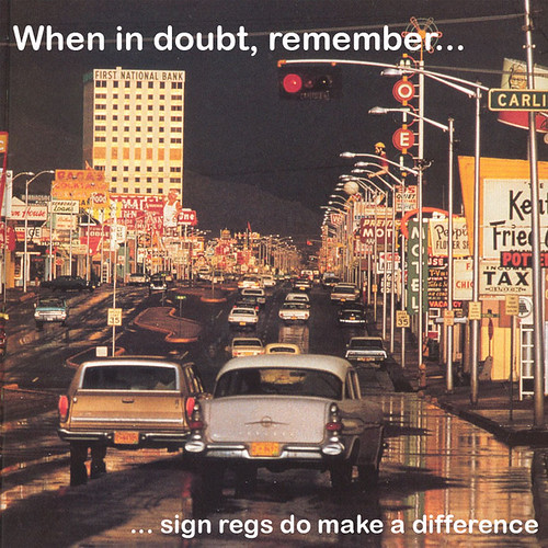
Route 66, Albuquerque, mid 20th century. Photo by Ernst Haas.
Cross-posted at Greater Greater Washington.
Average Rating: 4.4 out of 5 based on 270 user reviews.
August 26th, 2011 | Permalink
Tags: law, urbandesign
Check out the Railplane, a wacky proposal from the 1930s for a high speed rail system of elevated trains powered by airplane propellers.
From Wikipedia:
“The Bennie Railplane was a form of rail transport invented by George Bennie (1891–1957), which moved along an overhead rail by way of propellers. Despite superficial appearances, it was not a monorail, as it used both an overhead running rail and a guide rail below. It was intended to run above conventional railways, separating faster passenger traffic from slower freight traffic. A prototype ran over a 130-yard (120 m) line at Milngavie near Glasgow in the 1930s, but Bennie was never able to secure funding for further development and went bankrupt in 1937. The line was demolished for scrap in the 1950s.”

Average Rating: 5 out of 5 based on 228 user reviews.
August 22nd, 2011 | Permalink
Tags: fun, intercity, transportation
Congratulations to Norfolk for today’s opening of The Tide, Virginia’s first modern light rail line.
Flickr user parnelk63 has a nice collection of pictures from the opening day festivities, including the one below. The Hampton Roads Virginia-Pilot newspaper also has a great collection.

Average Rating: 4.4 out of 5 based on 239 user reviews.
August 19th, 2011 | Permalink
Tags: galleries, lightrail, transportation
Cycle tracks provide bikers with a high degree of separation from both automobiles and pedestrians. They are, by and large, very safe pieces of infrastructure. The one weakness of cycle tracks is at intersections, where car drivers turning out of the main roadway lanes parallel to the cycle track and onto cross streets may not always remember to watch for cyclists.
The 15th Street cycle track addresses this problem cleverly, with a pair of treatments intended to help drivers remember to watch for cyclists. The bike lane shifts over as it approaches an intersection so that car drivers can see if there are any bikes approaching in it, and the intersection itself is covered with sharrows and dashed lines. But can DDOT do more?
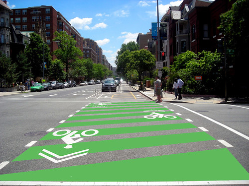
One addition to the cycle track that would surely be welcomed by cyclists would be green zebra striping. Zebra striped pedestrian crossings are extremely common all over DC, and the city has recently experimented with green bike lanes. It seems like common sense to combine two successful ideas in order to improve the safety of our facilities.
Here is a quick rendering of what this idea might look like:
Average Rating: 4.4 out of 5 based on 290 user reviews.
August 18th, 2011 | Permalink
Tags: bike, proposal, transportation
As urban cycling becomes more common, new terms are entering the lexicon that people may not be completely familiar with. This post will provide a guide to the most common types of urban bikeways.
There are seven basic types of bicycle travelways. In increasing order of separation quality, they are:
Mixed traffic
 |
|
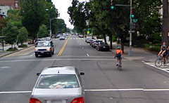
Mixed traffic bikeways are simply regular streets on which bikes are permitted to mix with cars. Almost every street in existence qualifies, except those with dedicated bike facilities, or the few where bikes are specifically outlawed. Many jurisdictions designate some streets as “suggested bike routes, ” which are mixed traffic streets that are deemed to be inherently bike-friendly, but where no (or limited) special treatments have been applied. Arlington’s bike map provides a good example: white-colored streets are normal roads, while blue-colored streets are suggested bike routes. Both white and blue qualify as mixed-traffic bikeways. Some cyclists prefer to ride in mixed traffic rather than on dedicated facilities. Photo by Google. |
Sharrow street
 |
|
Sharrow streets are mixed traffic roads on which graphics have been applied to the roadway indicating that cars and bikes should share the full lane as equals. Sharrows notify cars that they should expect bicycles on a street, and indicate to bicyclists that is safe to ride in the center of the street rather than on the sidewalk or in the door zone. They are the minimum bike-specific infrastructure for streets. Photo by Eric Gilliland. |
Bike lane
 |
|
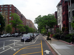
Bike lanes are the most common type of bike-specific infrastructure in most cities. They are lanes painted onto a street that are designated for use by bicycles, but which are not physically protected from lanes used by cars. Most bike lanes are located on the extreme right of the through part of the street, but to the left of the parking lane or right-turn lane (if they are present). The most common type of bike lane is designated with white paint as shown in the picture, however some jurisdictions take the extra step of painting them green or blue at key locations in order to increase visibility. Another modification to the standard bike line is to add a painted buffer that increases the separation between bikes and cars. Painted or buffered bike lanes may be considered “enhanced.” On high-speed roadways shoulders are often used as minimal bike lanes. Photo by Google. |
Bike boulevard
 |
|
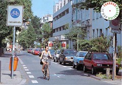
Bike boulevards are streets specifically optimized for bikes through a variety of techniques, but on which cars are also permitted (though sometimes discouraged) to operate in mixed traffic. Optimization techniques are not standardized, but may include lane markings, chicanes (and other traffic calming measures), car access restrictions, bike-optimized intersection treatments, and any number of other potential enhancements. Although bike boulevards are technically mixed traffic streets, the degree of extra bike-specific infrastructure is considerably greater than on sharrow streets. As far as BeyondDC is aware, there are not currently any bike boulevards in the DC area, although Arlington is considering two parallel to Columbia Pike. Photo by “Fahrradstrasse – Radfaher sind hier tonangebend”. |
Sidepath
 |
|
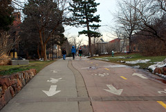
Sidepaths are off-street bikeways that are built as extensions of the sidewalk. They provide complete physical separation from cars except at intersections with cross streets. Some sidepaths are shared with pedestrians, while others designate separation from pedestrians using paint or unique paving materials. Those that do are sometimes referred to as a subset of cycle tracks since they are intended to be exclusive to bikes, but they have a lesser degree of separation from pedestrians than true cycle tracks. Photo by BeyondDC. |
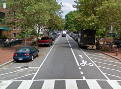
Cycle track
 |
|
In North American usage, cycle tracks are bikeways that are completely exclusive to bikes, physically separated from all other modes. The most common form is as an on-street bike lane placed between the curb and row of parked cars, but separation can also be obtained through other means such as bollards or additional curbs. Cycle tracks can come in many shapes and sizes, and are generally considered to be the pinnacle of street-adjacent bikeways. In Europe the term is more general and can be synonymous with bike lane. Photo by BeyondDC. |
Trail / shared-use path
 |
|
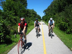
Trails are dedicated car-free travelways that follow their own unique route. They are intended to be not only off-street, but to be completely free of any interaction with cars at all. Even street crossings are intended to be extremely rare, and ideally are grade separated. Most trails are technically shared-use paths, which means pedestrians are permitted to use them as well. Nevertheless the degree of separation from cars is so desirable that trails are generally considered to be superior to cycle tracks and all other forms of bike infrastructure. Photo by TouringCyclist. |
Of course the full gamut of bicycle infrastructure includes many other types of enhancements, such as bike boxes and bike stations, but these are the seven basic types of bicycle travelways available.
Cross-posted at Greater Greater Washington.
Average Rating: 4.9 out of 5 based on 272 user reviews.
August 17th, 2011 | Permalink
Tags: bike, featured post, transportation
I am a fan of wrapping trains and buses in advertisements. It adds color and interest to city life. Here are a couple of creative bus wraps that put WMATA’s old Go Green campaign to shame.

Bus in Copenhagen advertising their zoo. Photo source unknown.
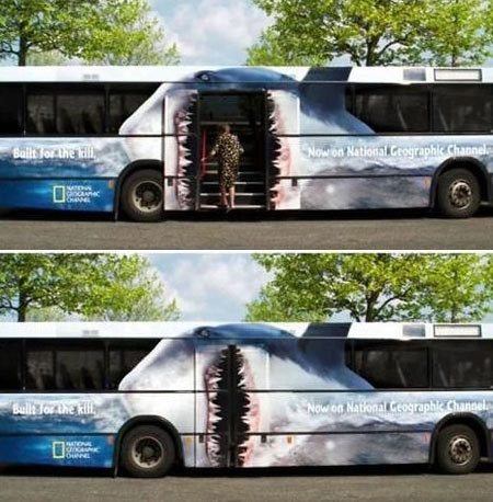
Bus with shark mouth doorway. Photo location and source unknown.
Average Rating: 4.4 out of 5 based on 218 user reviews.
August 12th, 2011 | Permalink
Tags: bus, fun, galleries, transportation
|
Media


Site
About BeyondDC
Archive 2003-06
Contact
Category Tags:
Partners
|